深圳东部海堤重建工程(三期),深圳,中国
2022-01-28KCAP建筑与规划事务所FELIXX景观建筑与规划事务所
KCAP 建筑与规划事务所,FELIXX景观建筑与规划事务所
客户:深圳市水务局 · 深圳市水务工程建设管理中心
设计团队:
总体规划+景观设计:KCAP Architects & Planners | Ruurd Gietema,Ya-Hsin Chen,Danli Sheng,Jiabiao Lin,Gaia Dal Cero,Gabriella Georgakaki,Emmanouil Prinianakis,Kallirroi Taroudaki,Pieter Theuws;FELIXX Landscape Architects & Planners | Michiel Van Driessche,Maria E.Castrillo,Eduardo Marin Salinas,Fangfei Liu,Ilva Mishtaku,Ramona Stiehl,Natalia Andreeva,Klaudio Ruci,Zamira Abazi,Naya Tzika-Kostopoulou,Shuangyun Chen,Nancy Smolka
设计总包:中交水运规划设计院有限公司 | FANG Aidong,ZHU Jiankang,LI Yongye,ZHANG Mingming,LI Jiangwen,GUO Lei;深圳翰博设计股份有限公司 | QIN Cao,GAN Haitao,HUANG Junyong,WAN Hao,CHEN Youyou,YANG Yong,XIAO Yuling,GAN Haitao,HUANG Junyong,WAN Hao,CHEN Youyou,YANG Yong,XIAO Yuling,LIU Xiaoming,SUN Feilong,WANG Hewen,XIAO Fengpin,LI Peng,MO Bingguang,GUO Zi,CAI Shengjie,LIN Hua
Structural Design:CCCC Water Transportation Consultants Co.,Ltd.Construction Drawing:Shenzhen Hope Design Co.,Ltd.
Consultant:Deltares (NbS Consulting) General Contractor:China Resources Land Urban Operation Management (Shenzhen) Co.,Ltd.
Structural System:Gravity retaining wall structure:The structure is based on shore and beach morphology,wind and wave conditions,material composition,and sediment movement.The foundation depth of the sea wall,the reinforcement method of the footing and the form of the superstructure are set to ensure the safety and stability of the sea wall.
Material:Nature stone,reinforced concrete,fair-faced concrete,colored concrete,exposed aggregate concrete,granite,stainless steel,etc.
Site Area:Masterplan for coast
protection and restoration:130 km;
detailed elaboration of coastline:18 km;including Yangmeikeng Demonstration Zone:520 m
Design Period:2019– present
Construction Period:2019– present Completion Time of Yangmeikeng
Demonstration Zone:2020.05
Completion of the Whole Project:2023 expected
Drawings:KCAP+FELIXX
Photos:DUO Architectural Photography |ZHUO Hongduo;China Resources Group | ZHANG Xingzhong+CCCC First Harbour | CUI Hao
Client:Water resource bureau of Shenzhen Municipality
Design Lead:KCAP Architects & Planners |Ruurd Gietema,Ya-Hsin Chen,Danli Sheng,Jiabiao Lin,Gaia Dal Cero,Gabriella Georgakaki,Emmanouil Prinianakis,Kallirroi Taroudaki,Pieter Theuws;FELIXX Landscape Architects & Planners | Michiel Van Driessche,Maria E.Castrillo,Eduardo Marin Salinas,Fangfei Liu,Ilva Mishtaku,Ramona Stiehl,Natalia Andreeva,Klaudio Ruci,Zamira Abazi,Naya Tzika-Kostopoulou,Shuangyun Chen,Nancy Smolka
Design Contractor:CCCC Water Transportation Consultants Co.,Ltd.| FANG Aidong,ZHU Jiankang,LI Yongye,ZHANG Mingming,LI Jiangwen,GUO Lei;Shenzhen Hope Design Co.,Ltd.| QIN Cao,LIU Xiaoming,SUN Feilong,WANG Hewen,XIAO Fengpin,LI Peng,MO Bingguang,GUO Zi,CAI Shengjie,LIN Hua
结构设计:中交水运规划设计院有限公司
施工图设计:深圳翰博设计股份有限公司
顾问咨询:三角洲实验室(基于自然的解决方案)
总承建:华润置地城市运营管理(深圳)有限公司
结构体系:重力式海墙结构:基于岸滩形态、风浪条件、物质组成、泥沙运动,设置海墙的基础深度、堤脚的加固方式和上部面层结构形式,保证海墙安全稳定
材料:自然礁石、钢筋混凝土、清水混凝土、彩色混凝土、露骨料混凝土、花岗岩、不锈钢等
场地面积:130km海岸线修复和保护
规划设计;18km海岸线详细设计:包括520m的杨梅坑示范段
设计时间:2019至今
施工时间:2019至今
杨梅坑示范段竣工时间:2020.05
整体完成时间:2023
绘图:KCAP+FELIXX
摄影:DUO Architectural Photography |
ZHUO Hongduo;华润置地 | ZHANG Xingzhong+中交水运规划设计院 | CUI Hao
恢复海岸线的总体规划,提高对极端天气的保护标准
东堤位于大鹏新区,该新区是一个多山的半岛,紧邻香港和深圳,植被非常茂盛。2018年,台风“孟古特”对大鹏半岛的海岸线造成了不同程度的破坏。2019 年,KCAP+FELIXX团队中选,负责制定恢复海岸线和提高保护标准的规划。该团队制定了“三重海岸防线战略”,这是一个对130km 长的海岸线进行气候适应性重组的综合设计,将水上安全战略与生态海岸线恢复、海堤建设、景观和公共空间改造相结合。它重新塑造了大鹏的旅游身份,并促进了当地的经济发展。在生态和安全的前提下,它将当地文化与地理环境相结合,展现了海岸线的美丽和多样性。
三重海岸防线没有采用沿海地区通常由当地居民自己建造的常见保护墙,而是创建了3个开发区域,将它们精心嵌入项目地形,并回应每个区域的特定未来需求。该项目建立了一个“200 年回归期标准堤坝”,以保证对当地社区的生活和经济的安全保护。第一重“外堤”坝区通过波浪衰减、减少侵蚀和加强沉淀来增加抗灾能力。第二重“中堤”是加高的堤坝,以阻挡风暴潮和被海浪推高的水。我们并没有简单地把第二重提防视为一堵单一的防洪墙,而是将它设计成一个多功能区:一个令人兴奋的丘陵公园、一个带有城市长廊的高架海滨、一个潮汐公园,甚至一座公共建筑。第三重“内堤”是一个混合结构,按照海绵城市的方式管理雨水。这层提防实现了将邻近村庄和山区的所有径流缓冲、延迟并临时存放在雨林公园、雨林、森林、湿地和绿道中。在结构强度方面,设计遵循了当地的地质和土壤条件。一个双重排水系统负责处理极端天气条件下过多的山地径流和海浪,从而降低了堤坝的高度以获得更好的空间质量。天然岩石(重新)用以加固堤坝。许多当地的资源(如岩石和土壤)得以循环使用并替换回现场,加强海岸线应对侵蚀和未来的气候挑战的能力。海岸线附近现有的珊瑚礁和红树林将得到保护,以提高生态价值,并作为长期增长的保护线,成为抵御海浪的第一道防线,减少台风的影响。这种“低影响设计与开发”原则可以维持并确保项目前后场地的水文特征一致。
Masterplan to Restore Coastline and Raise Protection Standards Against Extreme Weather
East Dike is located in Dapeng,a mountainous peninsula in the direct proximity of Hong Kong and Shenzhen with an extraordinary lush and green environment.In 2018,the typhoon Mangkhut damaged the coastline of the Dapeng peninsula to various degrees.In 2019,team KCAP+FELIXX was selected to develop plans to restore the coastline and increase protection standards.The team developed the "Triple Dike Strategy",an integrated approach towards the climate adaptive reorganisation of the 130 km long shore.The project integrates water safety strategies with ecological shoreline restoration,seawall construction,landscape,and public space remodelling.It recreates the tourism identity of Dapeng and promotes local economic development.On the premise of ecology and safety,it combines local culture with the geographical environment and shows the coastline's beauty and diversity.

1 杨梅坑示范区Yangmeikeng Demonstration Zone

2-4 杨梅坑海洋大道Yangmeikeng Sea boulevard

5 杨梅坑在现有范围内的开发项目Yangmeikeng developments within footprint of existing structure
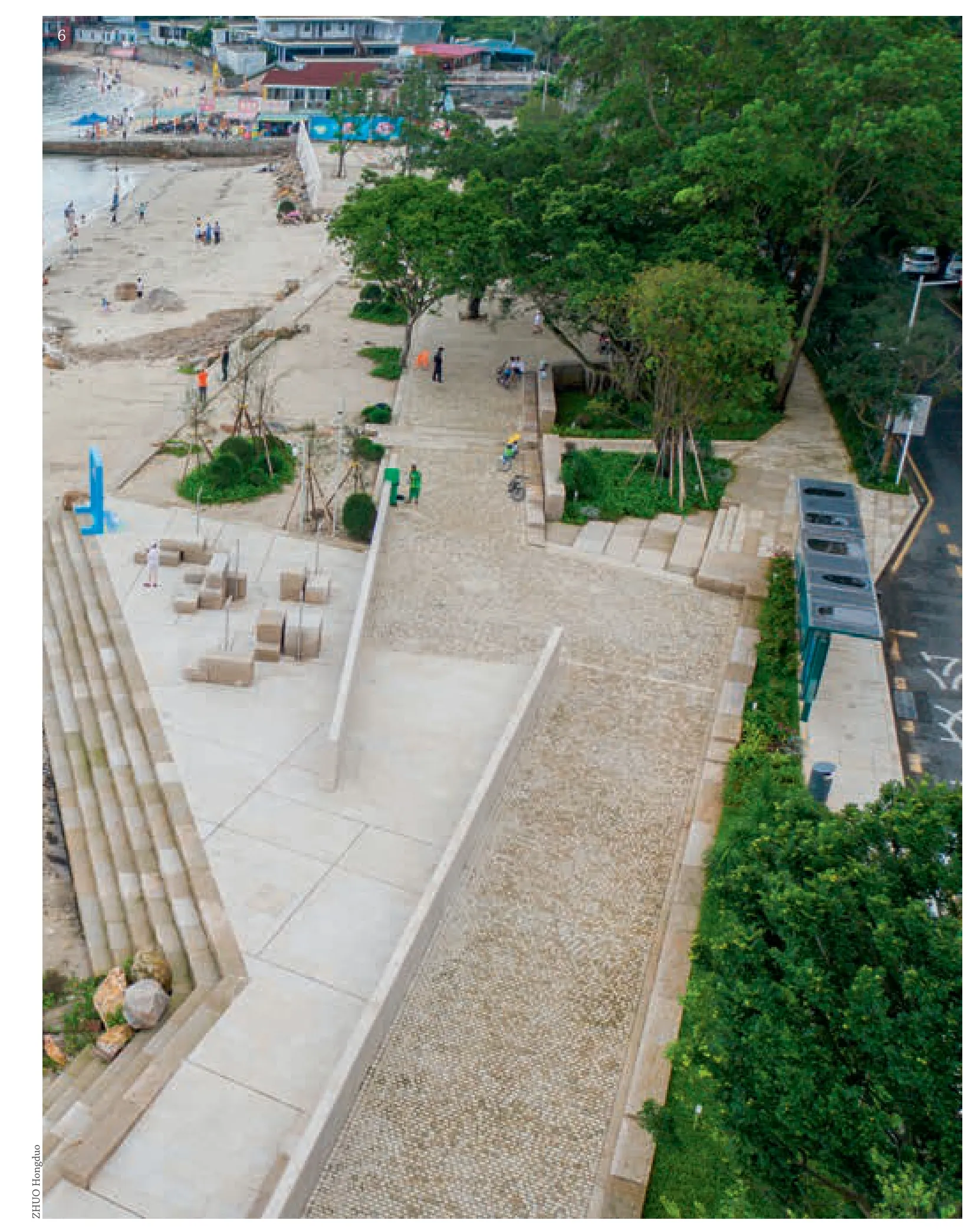
6 空中看杨梅坑示范区Yangmeikeng Demonstration Zone from the air
2020 年,杨梅坑500m 长的海上大道示范区已经完工。最近,两个台风“狮子山”和“康帕斯”(本季第17 个和第18 个)在中国南方岛屿登陆时,这一以自然条件为基础的三重海岸防线的表现得到了检验。多层面的防洪系统已经能够保护海滩和居民社区。该示范区是18km 长的堤坝建设的第一个里程碑,预计将在2023 年完工。该示范区以杨梅坑本身为基础,具有山与海之间的堡垒的特征。它提高了公共场所和服务的质量,提升了村庄的档次,使其符合旅游发展和居民的需求。自2020 年5 月完工以来,它已经为整个杨梅坑带来了比原来多30%左右的游客,为当地企业带来了20%的利润增长。东堤三堤策略保护了社区,是该村复兴的重要推动力,确保其在气候变化时期的复原力。
东堤与当地的3 个区——奎冲、大鹏、南澳,两个流域和9 个沿海旅游区进行协调,刺激了该村和整个地区的资源整合。它还与深圳正在进行的其他项目相互结合。□(钱芳 译)
评审评语
该重建项目的建筑师没有采用为130km长的海岸线修筑保护墙的传统方法,而是将海岸保护计划转变为对海岸的重组,同时为社会提供重要的附加价值。项目在海陆之间设置了3 个堤坝区,中间的多功能区则包括公园、长廊和公共建筑。该项目为气候问题——这一当今最紧迫的问题之一——提供了一个与众不同的答案:对极端天气和洪水进行控制,并将工程项目与极具价值的建筑空间和公共设施相结合。
The "Triple Dike Strategy" moves away from a generic protection wall along the coast,often built by the local population itself,towards the creation of three development zones,carefully embedded in current conditions and responding to the specific future needs of every single area.The project builds a "200-year return period standard dike" to ensure safety protection to protect the livelihood and economy of the local community.The first "outer" dike zone increases the resilience through wave attenuation,erosion reduction and the enhancement of sedimentation.The second "middle" dike is an elevated embankment,to stop the storm surge and the water pushed up by the waves.It is conceived not as a big wall but as a multifunctional zone:an exciting hilly park,an elevated waterfront with urban promenades,a tidal park or even a public building.The third "inner" dike is a hybrid structure which manages the rainwater following the principle of a sponge city.All runoff from adjacent villages and mountains is buffered,delayed and temporarily stored in rain-parks,raingardens,wet forests,wetlands and green streets.For the structural strength,the design follows the local geological and soil conditions.A double drainage system handles excessive mountain runoff and waves under extreme weather events.That allows reducing the dike height for better spatial quality.The natural rocks are (re)used to reinforce the embankment.Many local resources (like rocks and soil) were (re)cycled and replaced back onsite,to strengthen the shoreline against erosion and future climate challenges.Existing Coral reefs and mangroves near the shoreline will be maintained to increase the ecological value and function as a growing protection line in the long term,a first defence against the waves reducing the effect of typhoons.This "Low Impact Design & Development" principle maintains and ensures the same hydrological characteristics of the site before and after the project.
In 2020 the 500 m long sea boulevard,the demonstration zone,in the village of Yangmeikeng has already been completed.The performance of the proposed nature-based strategies for the "Triple Dike Strategy" here have already been tested when recently two typhoons Lionrock and Kompasu (the 17th and 18th of this season) made landfall in the South of China islands.The multifaceted flood protection system was already able to protect the beaches and residential communities.The demonstration zone is the first milestone in the construction of 18 km of embankment that is expected to be finished by 2023.The demonstration zone is based on the village Yangmeikeng itself with its characteristic identity of a fortress between mountains and sea.It improves the quality of public places and services,upgrading the village to match tourism development and residents' needs.Since its realization in May 2020,it has already brought the whole Yangmeikeng village around 30% more visitors and a 20% profit increase for local businesses.The East Dike Triple Dike Strategy protects the community and is a valuable driver for the village's regeneration,ensuring its resilience in times of climate change.
East Dike coordinates with three local districts:Kuichong,Dapeng,Nanao;two river basins,and nine coastal tourism zone,stimulating the integration of resources in the village and the whole region.It also combines with the other projects ongoing in Shenzhen.□
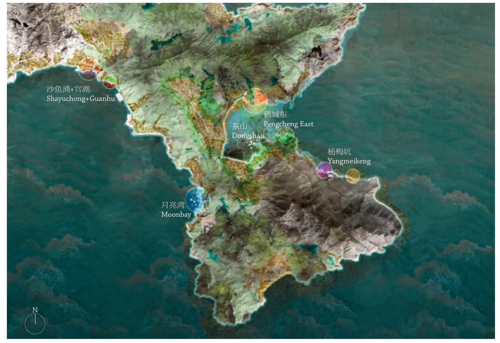
7 大鹏半岛总体规划Masterplan of Dapeng Peninsula

8 杨梅坑总体规划Masterplan of Yangmeikeng
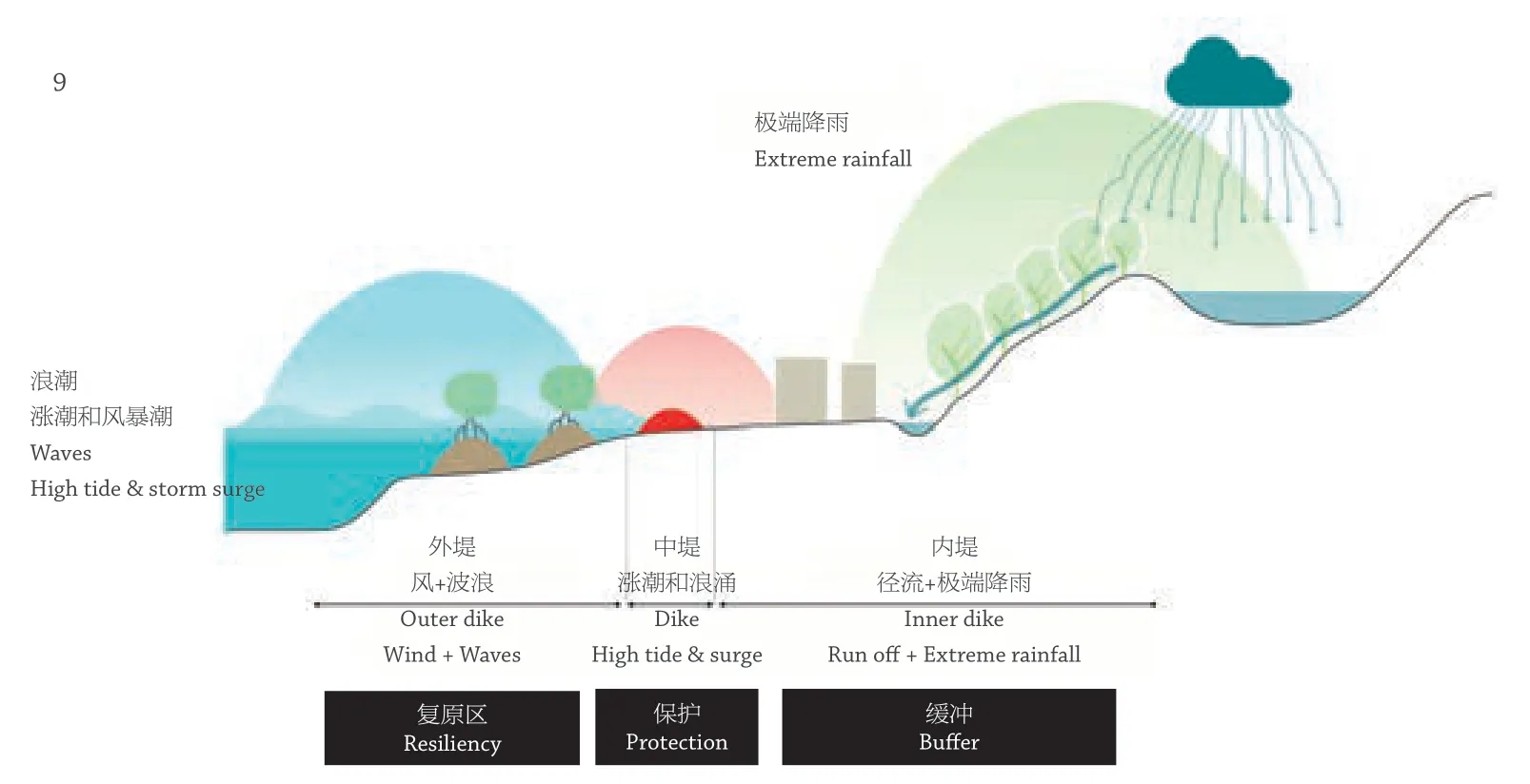
9 三重海岸防线Triple Dike Strategy
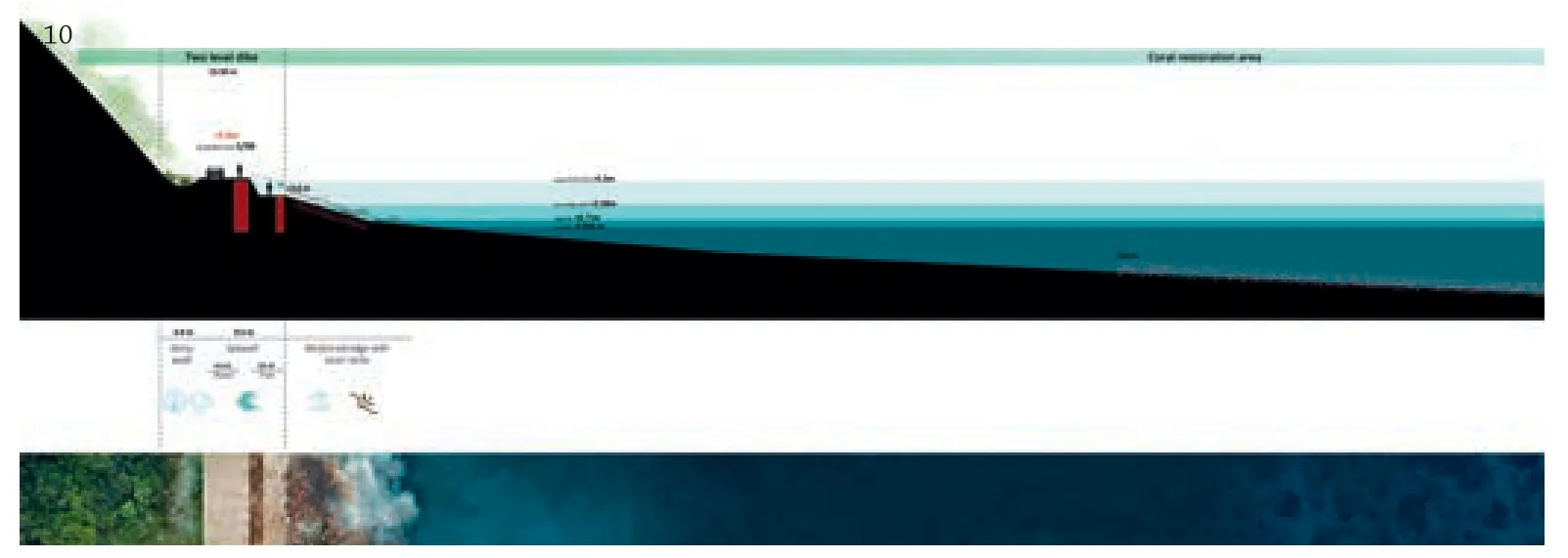
10 杨梅坑道路剖面Section of Yangmeikeng Road
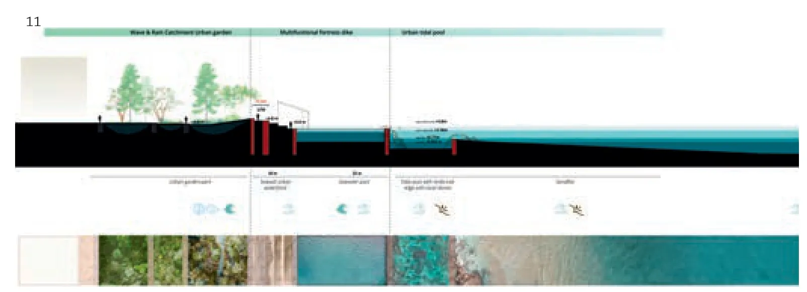
11 杨梅坑城镇剖面Section of Yangmeikeng Town
Jury Statement
Instead of furnishing the 130 km long coastline with a traditional protection wall,the architects turned the protection program into a reorganisation of the shore with significant additional value for the public.Three dike zones between water and land have been developed,the middle multifunctional zone making space for parks,promenades and public buildings.The project gives a differentiated answer to one of the most pressing problems today:severe weather phenomena and flood control and combines civil engineering with valuable architectural space and public amenity.
