瑶台失手玉杯空
2021-08-04张彝
张彝


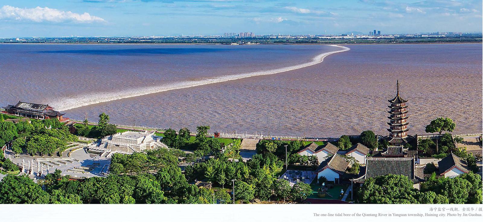
站在钱塘江边海宁古海塘上,面对眼前奔腾而过、万马齐喑的钱塘江涌潮,不禁生出“何以海宁潮”的感叹!在这颗蓝色的星球上,入海河流以数万计,何以独独钱塘江有此景象?北宋陈师道有诗《十七日观潮》,满足了我们无穷的好奇之心:“漫漫平沙走白虹,瑶台失手玉杯空。晴天摇动清江底,晚日浮沉急浪中。”我宁愿相信诗中充满无边暇想的演绎,就是眼前一切的答案,钱江潮就是那碧空之上神仙居住的瑶台边,仙女玉手偶失洒落的玉液琼浆。人间胜景绝景也不过如此了吧。
百尺楼前越王愁
在今天杭州萧山国际机场的西北面,有三座小山。吴越争霸之时,越王勾践于此修筑有楼,楼名“百尺”。南宋《咸淳临安志》记载:“盐官县百尺浦,在县西四十里。《舆地志》云:‘越王起百尺楼于浦上,望海,因以为名今废。”
公元前489年,战败入吴忍辱三年回国的勾践,时刻不忘复仇于吴,召计倪问伐吴之事。《越绝书》录勾践之言:“西则迫江,东则薄海,水属苍天,下不知所止。交错相过,波涛浚流,沈而復起,因复相还。浩浩之水,朝夕既有时,动作若惊骇,声音若雷霆。波涛缘而起,船失不能救,不知命之所维。”勾践为伐吴之事什么都愁,愁山、愁林、愁江、愁海、愁水、愁涛、愁船,愁吴有备,愁越粮道不通,愁谋不成或致不能胜。尽管当年的越国水上航运技术已经非常发达,跨越钱塘江已不是难事,但仍对喜怒无常的涌潮心有余悸。这是历史上第一次有关钱塘江涌潮的文字记载。
今天的钱塘江涌潮是闻名天下的自然奇观,是浙江最珍贵的旅游景观资源。但是,历史上,它曾经就是一个“祸害”,给沿海地区带来了诸多洪潮灾害,造成巨大损失。
《宋史·五行》记载较为详细:“嘉定十二年(1219),盐官县海失故道,潮汐冲平野二十余里,至是侵县治。芦洲港渎及上下管、黄湾黄冈等盐场皆圯,蜀山沦入海中。聚落田畴失其半,坏四郡田,后六年始平。”宋嘉定十五年(1222),专任盐官海塘事的浙西提举刘垕上书都省:“大海元与县治相去四十余里,数年以来水失故道,早晚两潮奔冲向北,遂致县南四十余里尽沦为海。近县之南元有捍海古塘亘二十里,今东西两段并已沦毁,侵入县两旁又各三、四里,止存中间古塘十余里。”
元泰定元年(1324)十二月,海水大溢,坏堤堑,侵城郭;二年(1325)八月,大风海溢,捍海堤崩广三十余里,徙民居千二百五十余家避之;四年(1327)正月,海潮大溢,捍海塘崩二十余步,四月复崩十九里。
明代自永乐至万历时期(1403-1620),海宁发生了五次较大的潮灾,造成大量房屋田地冲毁,居民大规模向北迁徙,史称“海凡五变”。清代顺治二年(1645)至乾隆二十三年(1758),钱塘江主槽在宽达20多公里南北岸线之间的“南大亹”“中小亹”和“北大亹”三条江槽通道上反复摆动,史称“三亹变迁”。不仅造成新的灾害,还引发了海宁与萧山行政区域的调整,江走“北大亹”安流后,江南原属海宁的土地于清嘉庆十八年(1813)转隶萧山。
江底沙坎催潮生
潮汐,是海水在月球和太阳引力作用下发生的周期性运动,地球上凡是海洋与陆地的交界处都存在这一现象。
涌潮,是潮差较大的喇叭形入海河口或者海湾出现的一种潮水暴涨的现象。如果没有其他特定的条件,按理说,全世界4万多条入海河流河口都会出现涌潮。实际情况却不是这样的,全世界只有16个国家、60余处河口和海湾存在或出现过涌潮,绝大多数的入海河口没有涌潮。其中最为著名的巴西亚马逊河、印度胡格利河、英国塞文河、加拿大芬迪湾等处,它们有和钱塘江河口一样的喇叭形状入海口,有比钱塘江更高的潮差,但是在涌潮的绝对高度、潮流速度、治理难度和观赏度等方面综合对比,唯钱塘江涌潮居首位。
钱塘江是浙江省最大河流,以北源新安江起算,河长588.73千米;以南源衢江上游马金溪起算,河长522.22千米。自源头起,流经今安徽省南部和浙江省,流域面积55058平方公里,经杭州湾注入东海。
钱塘江河口形状为喇叭型。其外口段杭州湾,上海南汇与浙江宁波镇海之间的湾口宽98.3千米,向内85千米至浙江海盐县澉浦与余姚、慈溪交界之间的湾顶宽仅19.4千米,东海潮波从台湾海峡北上经过舟山群岛进入杭州湾,随着江面迅速缩小,潮波能量集聚,潮差增大。
钱塘江河口属强潮型河口。平均潮差4米以上的河口为强潮型河口,实测钱塘江澉浦多年平均潮差5.57米,最大记录8.93米,比外口增加一倍。每潮进潮量35-50亿立方米。潮流流速强劲,最大流速12米/秒。高潮差、大潮量和强流速,加剧泥沙上下搬运运动,由于河口段泥沙主要由分选良好的细粉沙组成,极易淤积。
钱塘江水下有巨大的沙坎。钱塘江上游来沙少,年输沙量600-800万吨,比每潮进出河口的沙量(1000万吨)还少。在海宁段观测到,潮差3.6米时,一次全潮内,涨潮输沙量180万吨,落潮输沙量仅90万吨,净输入90万吨。大量泥沙随潮流行进而淤积,日积月累,自平湖乍浦至萧山闻家堰,形成长130千米、体积达425亿立方米、与河流同向的“沙坎”。“沙坎”使河床迅速抬升,水深变浅,潮流前锋受阻远较波峰为大,速度为慢,前坡逐渐变陡,到一定程度潮波破裂,于是钱塘江涌潮就出现了。(见林炳尧《钱塘江涌潮的特性》)
早在1964年,中国工程院院士、国内外著名河口海岸学家陈吉余在《钱塘江河口沙坎的形成及其历史演变》一文发表其研究结论 :“沙坎的形成以漏斗状河口为基本条件,涌潮形成又以沙坎为根据。”巨型沙坎,就是钱塘江涌潮产生的特殊条件。
潮起海宁越千年
海宁人称钱塘江涌潮为“海宁潮”,是因为它的起潮点在海宁,最佳观潮地在海宁。
南宋《咸淳临安志》记载 :“今观浙江之口,起自纂风亭,北望嘉兴大山,水阔二百余里。”与绍兴纂风亭相对的位置大概在今天海宁大、小尖山处。
1888年9月,英国皇家海军“逍遥者号”(RAMBLER)舰艇指挥官摩尔(MORRE)中校主持钱塘江涌潮的观测和沿江访问,在《钱塘江(杭州湾)涌潮》报告中,他认为,“完全可以得出下列一般结论:月圆和月相转变时,10时0分至10时30分之间,钱塘江涌潮形成于海宁东南方向12海里处的一个突出岬角尖山附近”。
1920年,上海开浚黄浦河道局在钱塘江北岸海宁段高阳山至盐官县城之间设置6个涌潮观测点,每分钟记录一次潮位,从各站潮位过程线的变化情况,判断大潮期间,涌潮大致在盐官以东21千米的小尖山附近形成。
20世纪60年代以前,钱塘江涌潮的起潮点基本没有变化,都在海宁尖山附近。60年代以后,随着大规模治江围涂,钱塘江江道缩窄,起潮点、观潮点和涌潮形态都发生了变化。从20世纪80年代中期开始,起潮点往东移至高阳山一线。此后钱塘江的治理同时落实保护涌潮的理念,治理措施所致的江道岸线变化,给自唐宋以来盛行的钱塘江观潮增添了意外的惊喜,海宁更是呈现出“全线可观潮、处处有潮景”的状态,最佳观潮点远不止“一潮三看赏四景”,自东向西依次如下:
嘉绍大桥。江道开阔,潮流速度快,因江中沙洲影响,形成东、南两股潮,大潮汛期间有“波纹潮”“两股潮”或“交叉潮”出现。
塔山坝。清代修建的塔山坝,坝顶伸向江心。西向潮流先折北至此,再折西而行,大潮汛时可见东潮、南潮、交叉潮和碰头潮等多种潮景,坝頂则有乱潮环绕景象。
大缺口。观看“碰头潮”的传统最佳景点。潮流至此被江中中沙截成两段,北段沿海塘继续西进,南段冲向南岸撞击海塘后北返,与东潮在江面上汇合碰撞,形成“碰头潮”或“交叉潮”。
八堡。观看“交叉潮”的最佳景点。若南潮速度快会冲上海塘,速度慢会形成“二度潮”。
盐官景区。观看“一线潮”的最佳地段。潮流至此融合西进,呈现齐头并进景象,称为“一线潮”。
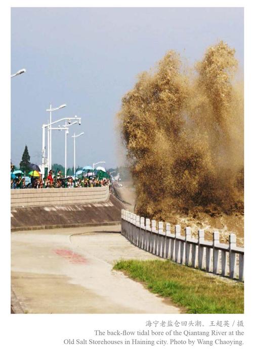
老盐仓。观看“回头潮”“冲天潮”的最佳景点。潮流至此撞击长650米的南北向丁字坝,潮头腾空而起形成水墙,折身返回与西涌潮流相互激荡着一路向东,在东面约600米处的海塘凹口处冲天而起,潮头高达10余米。
自标准海塘建成后,海宁海塘全线交通方便,设施完备,视线良好。农历每月初一至初五、十五至二十日大潮汛期间,每天白天、夜间均“两潮”可观,全线皆可观潮。
筑塘护城终安澜
对抗破坏力巨大的涌潮,最有效的手段是修筑海塘。海宁地处太湖流域最南端,海塘修筑关乎整个流域的安危,故历代均极其重视。因生产力水平所限,千年以来,人们与涌潮的斗争经历了从潮进人退到潮止塘下,从攻守相当到驯服涌潮、人潮共生的过程。
自唐至宋、元、明各代,古代海塘修筑的状况是屡筑屡毁,不断后退,以空间换取防御效能。
海宁古代海塘的修筑是从唐代开始的。《新唐书·地理志》记载:“盐官……有捍海塘堤,长百二十四里,开元元年(713)重筑。”此后各代史书、方志多有述及大海、海塘与县治的距离:
“海水,在县南七里。”(唐《元和郡县图志》)
“大海元与县治相去四十余里。”(元《宋史》)
“县南去海一里余。”(元《宋史》)
“在县东南一十里。”(南宋《咸淳临安志》)
“盐官州去海岸三十里,旧有捍海塘二。”(明《元史》)
“海在县治南一十里。”(明《成化杭州府志》)
“大海在县治南一十里。”(明《嘉靖海宁县志》)
“县治南即海,海之上即塘。”(明谈迁《海昌外志》)
海宁古代海塘的塘型,也经历了从土塘、柴塘、竹笼石塘、斜坡式石塘到直立式石塘的演变过程。
唐开元元年重筑的捍海塘即为土塘。宋代未见有石塘的修筑记载,宋仁宗延祐年间,有议筑石塘,却并未实施,应仍为土塘。南宋《咸淳临安志》中有《盐官县境图》一幅,图上县治与大海之间有“捍海塘”“范蠡塘”各一条。元代改进五代十国时期吴越王钱镠修筑杭州捍海塘使用的“竹笼石塘”,用石囤木柜抢险抵御涌潮。天历元年(1328)潮患渐息,石囤木柜基本完好,于是改“盐官州”为“海宁州”。明代仍沿用石囤木柜救急,未修筑石塘。清代,钱塘江江槽发生重大改变,康熙五十九年(1720)江槽走“北大亹”,浙江巡抚朱轼改进明代嘉靖年间浙江佥事黄光升发明的“五纵五横鱼鳞石塘”,主持修筑老盐仓鱼鳞大石塘500丈,这是海宁历史上首次修筑石塘。此后雍正、乾隆两朝,全力修筑海宁石塘,至乾隆四十九年,海宁海塘均已建成鱼鳞大石塘。自此,潮水终于止步于塘下,钱塘江涌潮的治理进入攻守相当的阶段。
清代乾隆以后,海宁海塘基本处于修损补缺的状态。民国时期,采用混凝土等新技术修筑海塘的工程量很小,一线抵御钱塘江涌潮的重任仍由清代古海塘支撑,加上战乱失修,工程老化,塘顶偏低,难以抗御洪水强潮的侵袭。
新中国成立以后,钱塘江河口进入了系统化治理的新时代,特别是海宁标准海塘工程建设,按抗御一百年一遇洪潮高水位和12级台风标准,自1996年11月至2005年底,55.66公里全线完成建设。钱塘江涌潮第一次听从我们的指挥,成为今天人们喜闻乐见的旅游景观资源。
今天的人们,若想重睹钱江潮走龛赭两山间的景象已不可能,唯有诗文画作或想象可聊作寄托。清代盐官城北白马寺僧达受观《潘松墅月夜观潮图》,触景生情,遂题诗曰:
赭龛两点影朦胧,卷起银涛浴碧空。
惟有月轮推不去,定光还在浪花中。
Haining Tidal Bore: Past and Present
By Zhang Yi
Standing on the ancient seawall in Zhejiangs Haining city along the Qiantang River, and facing the surging tidal waves of the river, one cant help but wonder: why Haining tidal bore? Tens of thousands of rivers are flowing into the sea on this blue planet, but why is it only in Qiangtang River that this specular scene can be found? Some clues might be discovered in “Watching the Tidal Bore on the Seventeenth Day of the Lunar Month”, a poem written by the Song (960-1279) poet Chen Shidao (1052-1102):
On the endless beach, come up the tides like a white rainbow.
The nectar from the fairies jade cup they are, accidentally poured to this mortal world.
The blue sky is swinging in the bottom of river,
and the setting sun is bobbing in the rapid waterflow.
Imaginations aside, the Haining tidal bore goes back a long way. “On the west lies the big river, and on the east lies the great sea…when the tides surge up, they are so horrifying that they sound like thunders, and once the ships are lost in the tides, there is no way to recover them as well as the lives,” said Gou Jian (ca. 520-465 BC) in 489 BC, when the king of the State of Yue (2032-222 BC) asked one of his advisors for the possibility of military campaign on Yues archenemy, the neighboring State of Wu (ca. 12th century-473 BC) to the north. Back then, Goujian just returned to Yue after being imprisoned for three years in Wu. Among Goujians many concerns for possible defeat in his revenge, the unpredictable tidal waves weighed heavily on him, despite the fact that Yue had already been leading the way in water transport technologies and there was no difficulty in crossing the Qiantang River.
Goujians concern, documented in the Yuejueshu, or the Glory of Yue, is believed to be the first written record of the Qiantang River tidal bore, which is now one of the most stunning natural wonders in the world. While it is undoubtedly Haining citys most valuable tourism resource, the tidal bore was once considered a major scourge, causing much damage.
“In 1219, the tidal waves flooded into Yanguan county [in present-day Haining] for over 20 li [10 kilometers]…destroying half of the fields along the way, the recovery of which took six years,” according to the History of Song. In 1222, a local official reported: “The county seat was originally 40 li away from the sea, but the changing water course and the tidal bore have flooded the area, with sea water now running 40 li to the south. The seawall, which was originally 20-li long, has only the middle section of about 10 li left, while the other parts are all breached and destroyed.”
In the 12th lunar month of 1324, seawater ran over the embankment and went all the way to the city walls; in the eighth lunar month of 1325, heavy winds and overflown seawater breached the embankment for over 30 li, more than 1,250 households had to relocate; and in the first lunar month of 1327, some 20 li of embankment was destroyed by the rising seawater and another 19 li was destroyed in the fourth month.
From 1403 to 1620, five major tidal disasters hit Haining, shattering houses and damaging fields, and a large number of residents had to migrate to the north. In the 23 years between 1645 and 1758, the course of the Qiantang River oscillated repeatedly along a section that was 20 kilometers wide from north to the south, which brought not only fresh destruction but also administrative redrawing between Haining and Xiaoshan.
Tides are the periodic movement of sea water caused by the combined effects of the gravitational forces of the Moon and the Sun, and the rotation of the Earth. Wherever the sea meets the land, tides can be seen.
A tidal bore, on the other hand, is a tidal surge occurring in a horn-shaped estuary or bay with a large tidal range. Theoretically, the estuaries of more than 40,000 rivers entering the sea around the world should have tidal surges. In fact, that is not the case: tidal bores can only be seen in 60 estuaries and bays in 16 countries. Among the most well-known are the Amazon River in Brazil, Hooghly River in India, River Severn in the UK and Bay of Fundy in Canada. While they all share a similar horn shape as the Qiantang River estuary, have larger tidal ranges, their tidal bores are dwarfed by the Qiantang tidal bore in terms of absolute tidal height, tidal speed and spectacle.
As the largest river in Zhejiang province, the Qiantang River runs a total length of 688 kilometers and covers an area of 55,558 square kilometers. The formation of the tidal bore results from the unique features of the Qiantang River. For one thing, its mouth is horn-shaped: at the inward side where the river mouth starts, the width stands at 19.4 kilometers while, flowing for 85 kilometers, at the outward end where it meets the Hangzhou Bay, the width increases to 98.3 kilometers. When the sea waves crash down from the East Sea into the Hangzhou Bay, the tidal energy builds up and the tidal range increases rapidly as the Qiantang River shrinks as quickly.
Although widely known as the Qiantang River tidal bore across the world, the tidal wave is called the “Haining tidal bore” by Haining people, as it is from Haining where the tidal bore starts. For example, Annals of Linan during the Reign of Xianchun, written in the Southern Song (1127-1279) period, put the forming of the tidal bore at somewhere near Hainings big and small Jianshan Mountains. “…I feel justified in submitting to you the following general conclusions. At full and change of the moon the Bore of the Tsien-tang Kiang originates between X. h. and X. h. 30 m. in the neighbourhood of the meridian of Chi-san [Jianshan], a conspicuous hill 12 miles E. by S. 1/2 S. from Haining,” wrote Captain William Moore (1849-1918) in Report on the Bore of the Tsien-tang Kiang, the first detailed description of the Qiantang River bore by a Western observer. Indeed, successive surveys and investigations before the 1960s all put the area near Jianshan Mountain as the place where the tidal bore originated, before it moved eastwards to Gaoyang Mountain when extensive management and reclamation measures on Qiantang River were instituted.
While Haining has historically boasted the best watching spots for the tidal bore, visitors now can appreciate the tide even more conveniently, thanks to the construction of a “standard seawall”. Throughout centuries, Haining people have built all sorts of embankments, causeways and dams to try to tame the waves, with varying degrees of success. The founding of the Peoples Republic of China has ushered in a new era of systematic governance for the Qiantang River estuary. Of particular note is the Haining Standard Seawall, running 55.66 kilometers and built between November 1996 and the end of 2005, which can withstand not only strong waves but Category 12 typhoons.
Now, rather than an affliction to be avoided, Haining tidal bore has become a veritable tourist spectacle. From the first day to the fifth day, from the 15th to the 20th day of every lunar month, when sea waves are most active, people are able to watch the tidal bore along the Standard Seawall twice, once at daytime and once at night, with a wide range of facilities and amenities provided.
