Effect of mangrove forest on coastal hazards reduction
2020-08-12LIUZhaoyangHUANGHaiyanZHANGYujiaZUOGuochengLIUChangPANSongLIXiao
LIU Zhaoyang,HUANG Haiyan,ZHANG Yujia,ZUO Guocheng,LIU Chang,PAN Song,LIXiao
National Marine Data and Information Service,Tianjin 300171,China
Abstract:In recent years,natural disasters in coastal areas have become more frequent due to sea level rise and other impact factors under the scenario of global warming,causing great losses to human society.Mangrove forest,an important shelterbelt in coastal areas,plays an extremely important role in reducing the coastal hazards risk.In this paper,the effects of mangrove ecosystem on coastal hazards reduction are reviewed from the aspects of wind prevention,wave attenuation,sedimentation acceleration,tsunamis mitigation,and provide theoretical support and technical guidance for the protection and cultivation of mangrove forests.
Keywords:mangroves,coastal hazards reduction,wind prevention,wave attenuation,sedimentation acceleration,tsunamis mitigation
With the effect of climate change and human activities,the global mean sea level is increasing year by year[1].High sea level has intensified the occurrence of natural disasters,such as storm surges,coastal erosion,saltwater intrusion and flooding in coastal areas,bringing a series of ecological and socio-economic pressure to coastal areas.An extreme example was the tropical cyclones called Mangkhut which crossed the north of Philippines and landed in Guangdong,China in September 2018.The storm surge affected more than 2.4 million people and 550 000 hectares of agriculture land.There have been growing calls for the consideration of the role of natural coastal ecosystems in coastal disaster reduction[2].
Mangrove is a kind of woody community of tidal beach wetland growing in the mouths of rivers,in tidal swamps,and along coastlines in tropical and sub-tropical regions[3,4].It is mainly composed of evergreen shrubs,arbor,liana and grass dominated by mangrove plants.Mangrove forests have iconic status as natural ecosystems that provide services to humans,and play important roles in wind prevention,wave attenuation,sedimentation acceleration and tsunamis mitigation[5].For example,the Indian Ocean tsunami of 26 December in 2004,one of the worst events in the recorded history of natural disasters,was responsible for the loss of 225 000 lives and millions of US dollars of property damage.However,the magnitude of the tsunami waves was less in places with healthy mangrove or coastal forests,such as in Ranong in Thailand,Andaman Islands and some parts of Tamil Nadu state in India[6].While it is clear that mangrove forest can significantly reduce wind and swell waves over a few hundred meters[7].There still remains a pressing need to better understand the roles that mangroves can play in safeguarding coasts against natural disaster.
Based on a large number of researches,this study focuses on mangrove forests and the roles they can play in the coastal hazards reduction from the aspects of wind prevention,wave attenuation,sedimentation acceleration,tsunamis mitigation.It is aimed to provide the theoretical support and technical guidance for protecting of the mangrove ecological system.
1 Wind prevention effect
As the first barrier of shelter forests in coastal areas,wind prevention effect is one of the main manifestations of mangrove forests.Studying the wind prevention effect of mangroves can provide basic information for quantifying the value of mangroves in disaster reduction and the later construction of the coastal ecological protection system.Considering the frequent tourism and fishing activities in the mangroves,the study also serves the need in the ecological security of coastal communities.
Researches on the wind prevention effect of mangroves have mainly focused on observations by ground-based instruments.Reports showed that the mangroves on the Queensland coast of Australia have greatly protected the port vessels in Hurricane"Larry",but the specific measurement data and simulation experiments of windproof performance have rarely been studied.Observation data showed that the wind speed was significantly reduced after its passing through the forest[8].The research did by Shenzhen Mangrove Nature Reserve showed that mangrove forests can resistant to the grade 11-12 largest wind[9].
On this basis,some scholars studied the impact factors of mangroves'wind prevention effect.Qiu et al.[10]did a field measurement analysis of the Dongzhaigang mangroves after the typhoon“Weimason”.The results showed that the wind prevention effect of shrubs is better than that of fast-growing trees because of their high density and good toughness.Chen et al.[11]found that structural characteristics such as forest density and foliage also have a certain effect on the wind prevention effect of mangrove forests.
Most of researches on the wind prevention effect of mangrove forests focused on the analysis of their influencing factors.From a qualitative point wind-attenuation through mangroves is expected to depend on a number of factors including species composition,mangrove density,vegetative morphology,structural complexity(roots,stems,branches and foliage)of the dominant species,forest width and storm characteristics(such as the size and forward speed of the cyclone).Research methods mostly use the combination of field investigation and theoretical models.
2 Wave attenuation effect
Mangrove forests are thought to play important roles in wave energy reduction[12,13].Researches showed that tsunami wave flow pressure was significantly reduced when the mangrove forest was 100 m wide[14]and mangroves appears to reduce surge from 5 cm/km(observed reduction rates)up to 50 cm/km(well-validated numericalmodels)[15,16].That’s mainly due to the trunks and overground roots of mangrove forests,which have considerable influence on the hydrodynamics and sediment transport within forests[17].
The current research on the wave attenuation effect of mangroves is carried out mainly in Southeast Asia,with research methods of direct observations[18-20]and models[22-25].
Direct observations are mainly for the mangrove forests in coastal area.Instrumented tripods(e.g.pressure-type stage sensor)for continuous observation were installed to collect data of wave characteristics such as wave height,wave spectrum,and so on[10,18].Then,the correlation between wave attenuation effect of mangroves and their characteristics for both vegetation and hydrological could be analyzed.By studyingSonneratia CaseolarisandSonneratia Apetalain Dongzhai Port of Hainan Island,Wang et al.[26]found that meteorological conditions could affect the wave attenuation effect of mangroves and proved that there was a certain correlation between the wave attenuation effect of mangroves and their stand height,tree belt width,density,tree species structure,tree age and tree flooding degree.The quantitative study conducted by Chen et al.[27]on the wave attenuation effect ofKandelia Candeland Sonneratia Apetalain the Dongzhai Port has once again proved that mangroves had a significant effect as wave attenuation and it was positively correlated with basal sectional area of forest stand,wave height,wave propagation distance,and negatively correlated with water depth.
The relationship between single factor and wave attenuation effect of mangroves is mainly established on simulation research due to complex and variable water depth,wave height,wind speed and wind direction in the natural environment together with heavy workload of field observation.At present,there are mainly two kinds of simulation methods of wave attenuation effect generally accepted domestically and internationally:an indoor flume experiment and a hydrological dynamic model.
In 1996,Zhang Jiachang[28]conducted an indoor flume experiment,took the trunk radius(r),the plant spacing(b),the crown radius(R),the forest belt width(B)and the incoming wave length(2L)as variables,and established a formula for calculating the wave attenuation coefficient K:
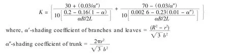
The application range of the formula was 0≤α′≤1.00 and 0.000 6≤α″≤0.009 1 for quantitatively calculating the wave attenuation effects of mangroves.This formula was then widely used for calculating the wave attenuation coefficients of mangroves under different conditions.
SWAN developed by the Delft University of Technology in the Netherlands is a widely recognized hydrological dynamic model.SWAN uses resistance parameters,vegetation density,height and diameter as vegetation characteristics to calculate the simulation parameters combining with hydrological data and simulate the wave attenuation effect at different levels(crown,trunk and root).The wave attenuation equation is further obtained by integration.SWAN is mainly suitable for the simulation in the neritic regions[29].
The current research on the wave attenuation effect of mangroves has become mature compared with wind prevention effect.Observation data were combined with theoretical models to found the wave attenuation effect of mangroves in different regions and types,which have provided theoretical support for storm surges in coastal areas.However,the observation data are limited for extreme weather condition such as strong typhoons,thus it is necessary to carry out further comprehensive and in-depth research through monitoring the wave attenuation effect of mangroves during the typhoons.
3 Sedimentation acceleration
The rise of sea level leads to the increase of tidal energy,which will aggravate coastal erosion,and compound the difficulty in restoring the eroded coasts.
Studies found that mangroves could keep up with sea level rise.In 1994,the core research plan under International Geosphere-Biosphere Programme(IGBP)listed the mangrove geoform process as the key research content.The growth zone of mangroves will be stable or expanding when the deposition rate of mangroves is greater than or equal to the rate of sea level rise;meanwhile the mangroves will retreat landward and threaten coastal level when the rate of sea level rise exceeds the deposition rate of mangroves.
A series of studies on the mechanism of siltation promotion of mangroves had been carried out.By studying mangroves in different countries,scientists found that mangroves had higher productivity.And the falling matters are the main organic matters and the important components in coastal sediment deposition[30].Zhang Qiaomin et al.[31]studied the sedimentation rates of mangrove tidal flats over the past 100 years,based on stakes and 210Pb dating,and found that the deposition rate had little to do with tree height and coverage but was mainly affected by sediment source,coastal dynamic background and beach face elevation.The siltation promotion of mangroves is also related to their biological types.Debasis pore divided the mangroves into hard substrate,soft substrate and transitional type.Later,it is found that the biogeomorphologic function of mangroves with hard substrate was weaker than that with soft substrate[32].
The study on the siltation promotion and land creation of mangroves shows that mangroves have complex surface and underground roots which can bond soil and promote tidal flat siltation[33],and their biogeomorphologic process is closely related to developed root system,high productivity,biological type,coastal background,and beach face elevation.However,most of them relied on field observations,rather than model analyses.The mechanism of biogeomorphologic process deserves further study so as to provide theoretical bases for better exerting the sedimentation acceleration function of mangroves and alleviating the coastal erosion process.
4 Tsunamis mitigation
Tsunamis are deadly natural disasters,which caused by earthquakes and landslides disturbing large masses of water.When tsunami waves approach land,they increase in height,sometimes become several meters high at the shore.Tsunamis can result in massive destruction and loss of life,as seen during the 2004 South Asian Tsunami(Indian Ocean Tsunami of 2004).While the water depths in both storm surges and tsunamis can be similar,tsunamis arrive more quickly as one or a series of waves that may appear and flood an area in seconds or minutes[33].From 1700 to 1930,the frequency of tsunamis had increased significantly,especially in Italy,India and Portugal,posing a serious threat to the safety of human life and property[34].There is growing evidence,particularly from the devastating Indian Ocean Tsunami of 2004 that mangroves reduced tsunamiimpacts by reducing the destructive energy of water flowing inland.
A series of investigations and studies on the interaction between mangroves and tsunami waves was done.Wang et al.[35]studied the transmission of tsunami waves through mangrove forest,and found that the height of transmitted solitary waves increases with increasing incident wave height and decreases with increasing density of mangrove forest.Hiraishi T and Dahdouh-Guebas[36]found that high-quality mangroves could effectively reduce damage caused by tsunamis meanwhile the atypical mangrove communities had a very weak defense against tsunamis,which proved that there was a certain relationship between buffer capacity of mangroves to tsunami waves and stand quality.
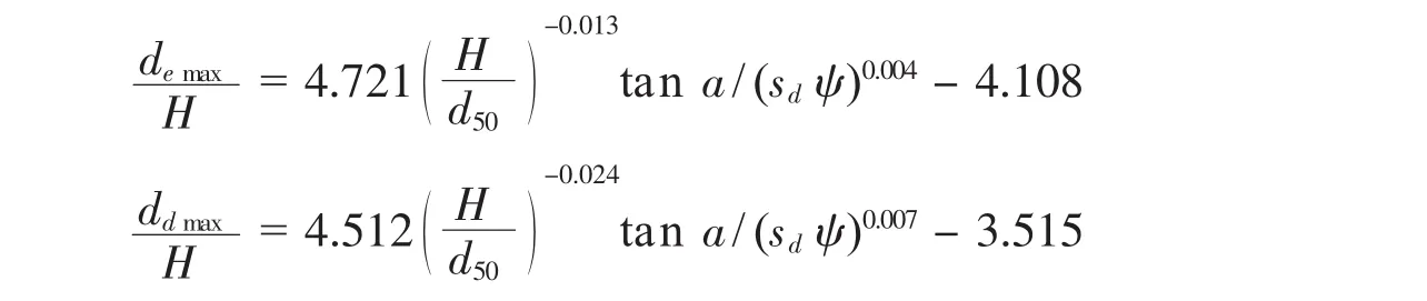
Mangroves can also effectively mitigate the damage to beaches caused by tsunamis.Chen’s[37]experiments were conducted to investigation the changes of cross-shore beach profiles by the tsunami wave sunder the influence of mangroves,and obtained the relationship between maximum of deposition/erosion depths(ddmax/demax),vegetationdistribution density,tsunami wave height(H/d50),beach slope(tan a)and sediment ratio(sd):
As it is difficult to study the relationship between mangroves and tsunamis quantitatively,there are also a lot of work need to be done.
5 Discussion
A large number of studies have proved that,as“ocean guardians”,mangroves can effectively prevent wind,attenuate waves,promote sedimentation,and mitigate tsunamis,which have made great contributions to coastal hazards reduction.
Unfortunately,these natural shields are declining day by day because of natural processes and increasing global demand for land,food and forest products.It is difficult to recover because of the changing environment and human interactions.According to a 2003 report of the Food and Agriculture Organization of the United Nations[38],there are less than 15 million hectares of mangrove forest[39]across 60 000 square miles of warm water areas of tropical oceans worldwide.As can be seen from Fig.1,the most extensive area of mangroves is found in Asia,followed by Africa and South America[40];approximately 41%of the world’s mangrove forests are in Australia,Brazil,Indonesia and Nigeria;60%of the total mangrove areas are situated in just 10 countries.Using an online forest monitoring platform,Global Forest Watch(GFW),found that the world lost 192 000 hectares(474 000 acres)of mangroves from 2001 to 2012,a total loss of 1.38%since 2000(or 0.13%annually)(Fig.2)[41].
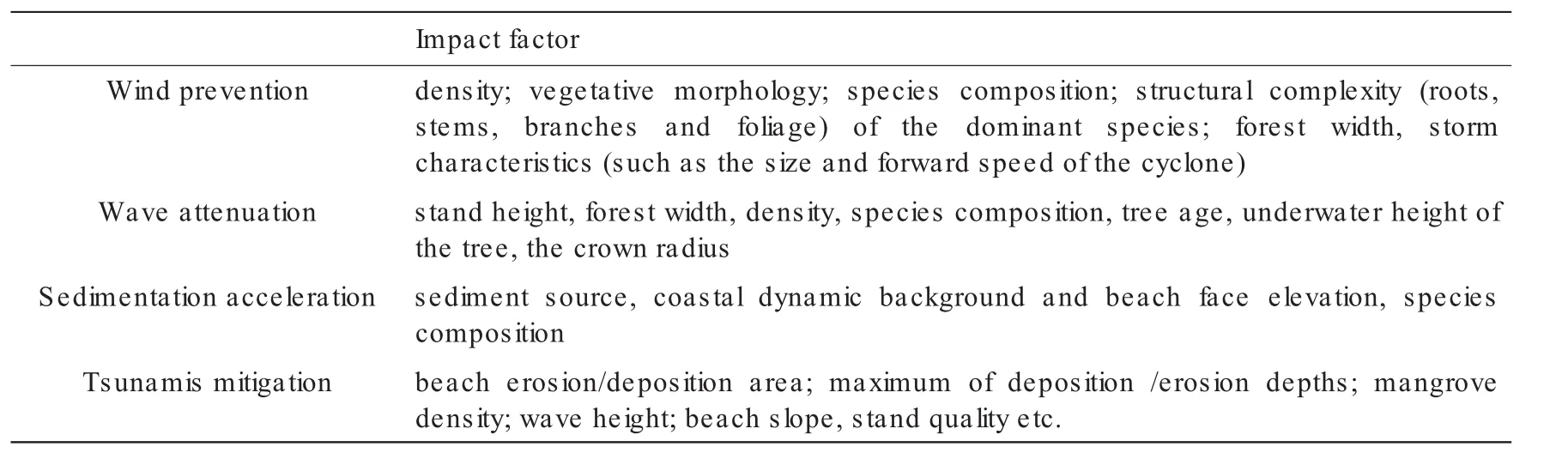
Tab.1 Impact factors of mangrove coastal hazards reduction effects
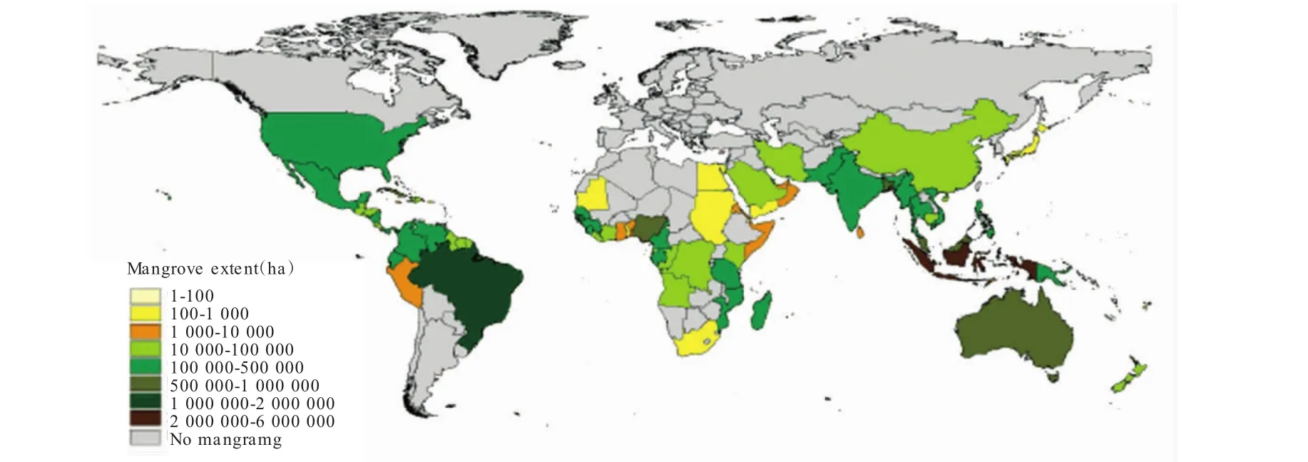
Fig.1 Mangrove extent per country(hectares)(source:Global Forest Watch(GFW)available at http://data.globalforestwatch.org)
The break of the mangrove destruction cycle is possible by prescribing appropriate strategies and the following implementation.Some measures and proposals are put forward as followed:
(a)Legislations at national and local levels should be enacted to protect mangroves from direct human damage.For example,the Florida Department of Environmental Protection(FDEP)implemented the Mangrove Trimming and Preservation Act.This Act regulates the trimming and alteration of mangroves while also banning the use of herbicides and other chemicals used to defoliate mangroves.Mangroves cannot be removed,trimmed,or disturbed without a permit from the FDEP.
(b)Government could also publish a series of incentive policies to encourage local mangrove planting,for example,reward construction land to local governments.
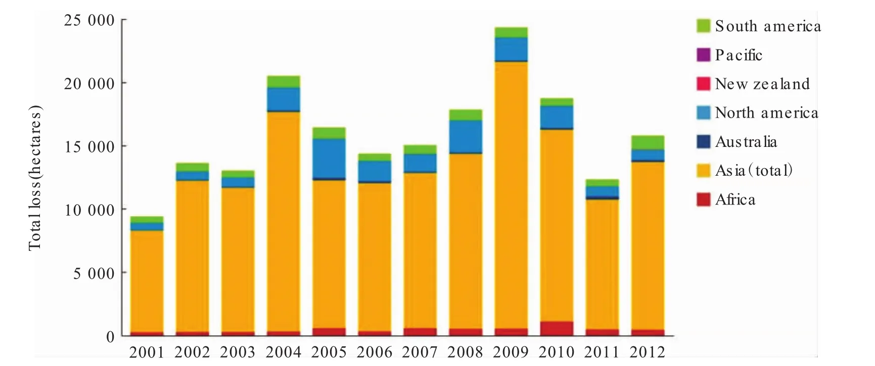
Fig.2 Tree cover loss in mangroves by year,2000-2012(source:World Resoures Institute,available at http://bit.ly/1ztb5ZI)
(c)Mangrove monitoring should be incorporated into the operational monitoring system of local ocean management authority,and monitoring indicators should include stand height,forest width,density,species composition,etc.
(d)Other efforts could be included into mangrove replenishment initiatives.This consists of the determination of the causes of mangrove loss followed by the removal of those causes.Within 15-30 years,mangrove habitat can once again become well-established if conditions are suitable.However,if seeds or propagules cannot reach the site,mangroves may be successfully established through replanting seedlings.
杂志排行

Marine Science Bulletin的其它文章
- Research progress of micro(nano)plastics in marine survey in China
- Bibliometric analysis of Ecopath model in different ecosystem in China
- The benthic diatom community of Xiangshan Bay
- An overview of studies on marine macrobenthic community structure and biodiversity in the Bohai Sea
- Introduction to marine emergency forecasting and early-warning system(MEFES)
- Estimating shoreline response to sea level rise:the equilibrium model