Multi-temporal InSAR for Urban Deformation Monitoring:Progress and Challenges
2020-05-18WUSongboLEYongyaoZHANGLeiDINGXiaoli
WU Songbo LE Yongyao ZHANG Lei DING Xiaoli*
①( Department of Land Surveying and Geo-Informatics,The Hong Kong Polytechnic University,Hung Hom,KLN,Hong Kong 999077, China)
②( Xi’an Engineering Investigation and Design Research Institute of China National Nonferrous Metals Industry Co.Ltd.,Xi’an 710000, China)
Abstract:Multi-temporal Interferometric Synthetic Aperture Radar (MT-InSAR)is one of the most powerful Earth observation techniques,especially useful for measuring highly detailed ground deformation over large ground areas.Much research has been carried out to apply MT-InSAR to monitor ground and infrastructure deformation in urban areas related to land reclamation,underground construction and groundwater extraction.This paper reviews the progress in the research and identifies challenges in applying the technology,including the inconsistency in coherent point identification when different approaches are used,the reliability issue in parameter estimation,difficulty in accurate geolocation of measured points,the one-dimensional line-of-sight nature of InSAR measurements,the inability of making complete measurements over an area due to geometric distortions,especially the shadowing effects,the challenges in processing large SAR datasets,the decrease of the number of coherent points with the increase of the length of SAR time series,and the difficulty in quality control of MT-InSAR results.
Key words:Urban deformation;Monitoring;Multi-temporal InSAR
1 Introduction
Urban areas often undergo various forms of ground deformation due to,e.g.,underground construction[1,2],land subsidence[3,4]and groundwater exploitation[5].Ground deformation can cause hazards such as flooding and damages to urban infrastructures,both above and below the ground surface,including buildings,roads,railway systems and water supply and sewage systems.It is critically important to study urban deformation,including deformation of both ground and infrastructures,to understand the spatial and temporal features of the deformation,to detect impending hazards or risks so that prompt remedial actions can be taken in time[6,7].Conventional geodetic techniques such as levelling and Global Navigation Satellite Systems (GNSS)have been widely used to monitor ground deformation.The technologies are accurate and reliable.They are however inefficient,labor-intensive and costly for large area measurements.
Space borne Interferometric Synthetic Aperture Radar (InSAR)has been developed into one of the most powerful geodetic technologies for large-area high-resolution deformation measurements mainly since the launch of the first civilian Synthetic Aperture Radar (SAR)satellite,SEASAT in 1987[8-11].Multi-Temporal InSAR (MT-In-SAR)techniques have been developed since about 2000 to overcome effects of decorrelation and atmospheric artifacts that affect significantly the accuracy and reliability of the conventional In-SAR technique[12,13].MT-InSAR has been widely used in various geoscience applications such as monitoring urban deformation[14-21].Tomographic SAR (TomoSAR)techniques have been proposed to further extend the capacity of SAR remote sensing into 3D or 4D measurements[22,23].We will however limit the scope of this review to not cover TomoSAR.
Research on InSAR has been increasingly popular over the past three decades as seen in Fig.1 where the number of publications with keywords InSAR and MT-InSAR (left y-axis)and the number of citations (right y-axis)included inWeb of Scienceeach year between 1990 and 2019 are shown.It can be seen that the numbers of publications and citations have shown general increasing trends although the number of MT-In-SAR related publications showed a big spike in 2014 and has flattened since then.The total number of InSAR related publications over the 30 years is 11,722 and the total number of InSAR related citations is 195,512,while MT-InSAR related total number of publications is 4,059 and the total number of citations is 38,260.
We will review the capacity and applications of MT-InSAR techniques in monitoring urban deformation.MT-InSAR algorithms and applications will first be outlined in Section 2,followed by a discussion of the challenges in such applications and conclusions in Sections 3 and 4,respectively.
2 MT-InSAR Algorithms and Applications
2.1 Development of InSAR and MT-InSAR
InSAR technique was initially developed for extracting ground surface elevation.It was then possible to extract ground deformation based on the Differential InSAR (D-InSAR)approach[8,9].Two SAR images over the same area are obtained at timeT1andT2with a repeat-pass SAR sensor (Fig.2).The differential phase along the line-of-sight direction,i.e.,Dr,is a sum of the contributions from the projected ground deformation,Dd,over the time interval,reference surface,topography,and the atmospheric artifacts,etc.The ground deformation is retrieved by removing the unwanted phase components as much as possible.Interested readers are referred to review papers[9-11,24,25]for a detailed description of the In-SAR principle.
MT-InSAR was first proposed in around 2000 to overcome some of the limitations of the D-In-SAR technique such as the atmospheric artifacts and decorrelation effect.MT-InSAR technique extracts the deformation of the so-called permanent or Persistent Scatterers (PS)based on a time series of SAR data over an area[12,13].Various versions of MT-InSAR techniques have subsequently developed including,e.g.,Small BAseline Subset(SBAS)[26],Interferometric Point Target Analysis(IPTA)[27],Spatio-Temporal Unwrapping Network (STUN)[28],Stanford Method for Persistent Scatterers (StaMPS)[29],SqueeSAR[30],Coherent Pixels Technique (CPT)[31],Persistent Scatterer Pair (PSP)[32],Temporarily Coherent Point In-SAR (TCP-InSAR)[33],and Coherent Scatterer In-SAR (CSI)[34].The key characteristics of some of the MT-InSAR approaches are given in Tab.1.The efforts of these developments have been in optimizing coherent point selection,observation model derivation,phase unwrapping,modeling various errors,quality control and computation efficiency.

Fig.2 Illustration of principles of differential SAR interferometry
Both Persistent Scatterers (PS)and Distributed Scatterers (DS)are used in MT-InSAR[12,26,30].The PS are pixels that have stable backscattering properties over time (e.g.,building objects)while DS represent pixels with homogeneous backscattering characters (e.g.,rural area)[26].Point selection can be carried out by various criteria,e.g.,phase stability[16],amplitude dispersion[31],coherence map[26],spectral diversity[27],offset deviation[21],and a posterior coherence[30,35].
A spatial network is normally used to link the selected points in the process of estimating the interested parameters.A temporal deformation model is typically assumed to detrend the phase ramp on an arc of the network[13,28].Certain points are removed in the process when they do not fit the deformation model with,e.g.,adaptive and hierarchical modeling approaches[36-39].Several phase filters and estimators have been proposed to enhance the phase quality in phase unwrapping,including statistic filtering[30,40]and temporal coherence optimization[35].In order to enhance the quality of MT-InSAR results,much efforts have been spent on modeling and mitigating the errors including satellite orbital errors[41-43],atmospheric delays[44,45],ionospheric effects[46-48],and DEM errors[49-51].
2.2 Applications of MT-InSAR in urban deformation monitoring
It is essential to monitor ground deformation in urban areas to better mitigate hazards related to the deformation,including,e.g.,flooding and damages to infrastructures.InSAR,especially MT-InSAR has been increasingly applied to study urban ground deformation and the related hazards.
2.2.1 Ground subsidence
Coastal cities such as Hong Kong,Macau and Shenzhen often reclaim land from the sea due to shortage of usable land.Reclaimed land normally undergoes a long period of settlement.The settlement rate varies from hundreds of centimeters to a few millimeters per year depending on the type of materials used for reclamation and the depth of the materials.In addition,underground mining such as water or oil extraction can also cause significant ground subsidence.MT-InSAR technique has become the most useful technology for studying ground subsidence due to its wide coverage and high spatial resolution.For example,ground deformation related to groundwater exploitation in northern China plain has been studied with MT-InSAR technique for better water resources management[52].Similarly,ground deformation of Beijing and Mexico City related to underground water usage has also been measured with the technique to better manage water resources[53-57].Fig.3 gives examples of ground deformation of Zhanghua-Yunlin,Taiwan and Beijing related to underground water exploitation.
Studies have been carried out to investigate ground settlement of the Hong Kong International Airport (HKIA)using both D-InSAR and MTInSAR techniques[3,4,58].Fig.4(a)shows an example of the surface settlement of HKIA and Fig.4(b)is a subsidence map of a landfill site in west New Territories in Hong Kong,all measured with MT-InSAR technique.MT-InSAR technique has also been applied to study land settlement of reclaimed land and landfill sites in Shanghai[59,60]and Shenzhen[61-63].Such settlement results from MT-InSAR technique can be validated by crosscomparison between multiple SAR datasets of the same ground area and by using ground survey results,e.g.,from leveling measurements.Ground changes due to rapid urbanization and urban redevelopments can cause decorrelation effect and reduce the number of points that can be further measured with advanced MT-InSAR[64].In addition,geometric distortions due to high-rise buildings can leave many parts of the ground surface unobservable.It is also important to carefully analyze the deformation results to separate points on buildings and on the ground as they reflect different kinds of deformation.
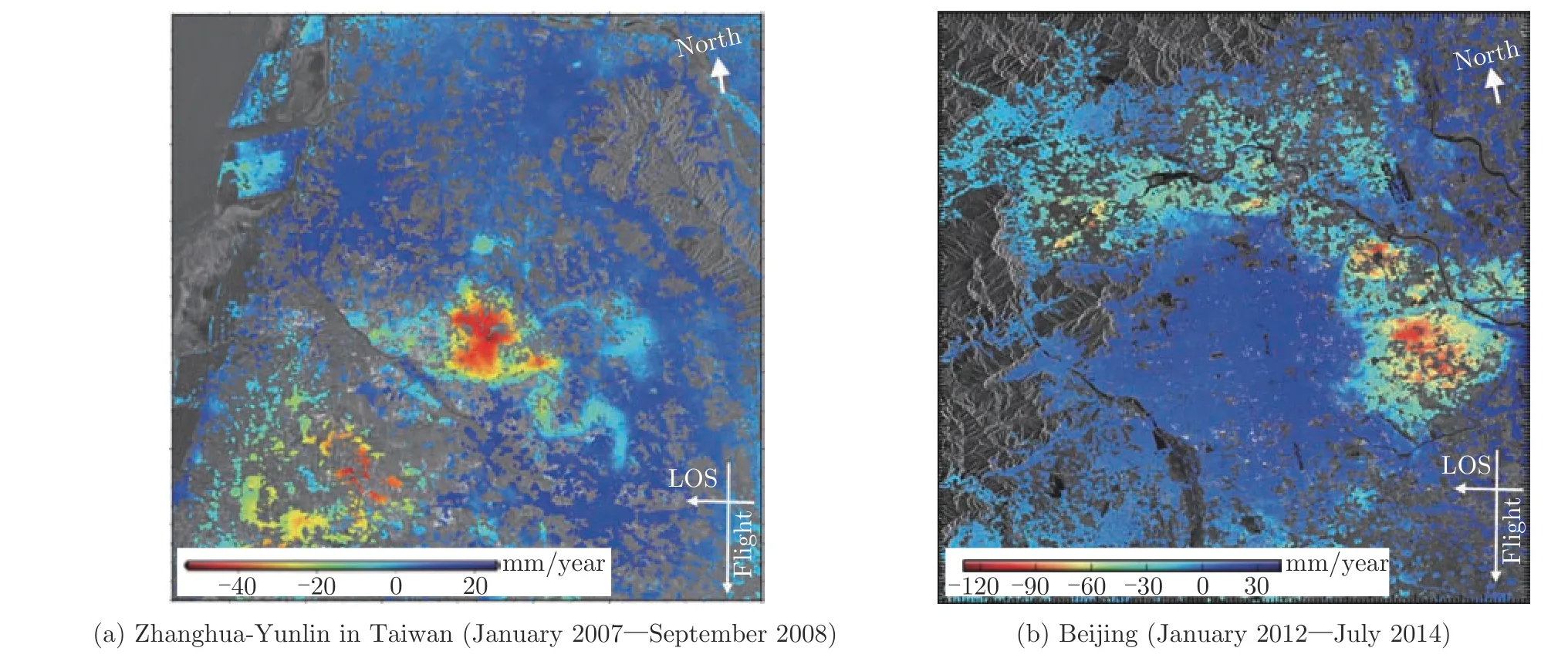
Fig.3 Deformation velocity map along line-of-sight directions
With the availability of abundant SAR images and the powerful computation capabilities,it has been possible now to monitor ground deformation on a national or regional scale to detect abnormal deformation hotspots.For example,national scale deformation monitoring has been carried out for Italy[65,66],the United Kingdom[67],and the entire railway network of the Netherlands[68].Fig.5 gives a ground deformation example of a majority part of Macao determined from a TerraSAR-X dataset.A challenge for large-scale ground deformation monitoring is how to process a large number of SAR images efficiently to derive and update the measurement results in real time or near real time so that prompt remedial actions can be taken promptly when needed[66].
2.2.2 Deformation due to underground construction
Underground construction such as subway projects can often cause ground deformation.MTInSAR technique has been used to map the temporal evolution of such ground deformation to better understand and manage the risks caused by the construction activities.For example,Fig.6 shows the deformation along some subway lines in Shenzhen city determined with the MT-InSAR technique and an ASAR dataset.The deformation along subway lines was clear and reached a rate of up to 20 mm per year.Similarly,the deformation due to subway tunneling in Beijing[69,70],Guangzhou[71],London[72,73]and Shanghai[1]have been studied,where the evolution of the deformation and subway construction activities can often be correlated.
2.2.3 Deformation of infrastructures

Fig.4 Subsidence velocity maps
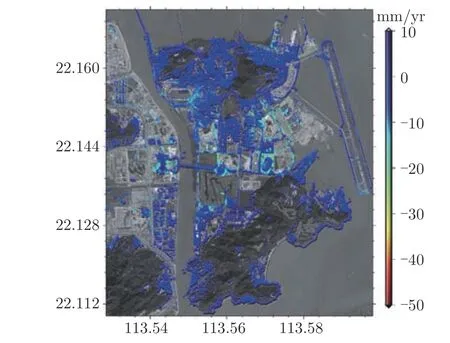
Fig.5 Ground deformation of Taipa and Coloane islands of Macao

Fig.6 Ground surface deformation related to subway lines in Shenzhen,China
Monitoring the deformation of urban infrastructures such as buildings and bridges can help to detect abnormal health conditions of the infrastructures.The wide coverage and high-resolution measurements of MT-InSAR technique can enable a large number of infrastructures to be monitored simultaneously.The technique has been widely used to monitor the stability of buildings[6,74-76].For example,deformation and thermal dilation of buildings have been extracted with MT-InSAR to assess structure stability of the buildings[77].Fig.7 gives an example of deformation rates of some buildings in part of the Kowloon Peninsula retrieved with MT-InSAR technique[78].The measured points are overlaid onto a Google Earth building model.The deformation of two points (i.e.,Point A and Point B)on a building shows periodical thermal dilation and is highly correlated with the temperature.Point A is on the top of the building and shows a much larger deformation than Point B that is on the bottom of the building.Deformation characteristics of railways and bridges have been studied extensively with MT-InSAR[79,80].For example,Fig.8 shows an example of the annual deformation rates of four main bridges in Hong Kong retrieved with MT-InSAR technique and TerraSAR-X data.Apparently,all the bridges suffered from some deformation and the most significant deformation normally occurred at the mid span.
It is understandable that it is difficult to monitor individual buildings or other structures in dense urban areas where geometric distortions and signal multi-path effects are rather common in the urban jungles.Therefore,combining data from multiple SAR platforms and other technologies such as GNSS and leveling may become necessary[81].
3 Challenges in Urban Deformation Monitoring
Despite the great success in advancing MTInSAR technique and applying it to urban deformation monitoring,there are still many challenges to be overcome.We will in this section discuss the main challenges in applying MT-InSAR to urban deformation monitoring and some possible solutions.
3.1 Inconsistency in PS point selection
Different criteria have been developed for selecting PS points in MT-InSAR data processing.The choice of a criterion and the associated threshold value depends largely on an operator’s experience[82].Therefore,different operators may use very different PS points and produce very different MT-InSAR results[78].For example,the PS points of an area in Shenzhen selected from 79 TerraSAR-X SAR images with different criteria and threshold values are shown in Fig.9.The area highlighted with the rectangle is a road.The number of points selected on the road is comparatively small due to the specular effect.Therefore,balancing the number of measurable points and the measurement quality for such areas is important.In addition,it will be useful to explore the relationship between the accuracy of MT-InSAR measurements and characteristics of the ground targets.
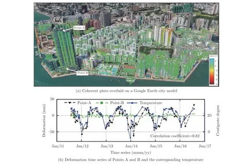
Fig.7 An example of deformation rates of the buildings[78]
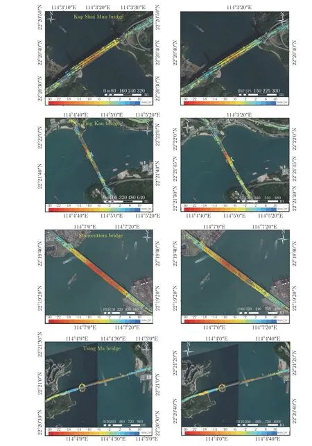
Fig.8 Annual deformation rates of four major bridges in Hong Kong.The first and second columns are the deformation rates over 2011~2012 and 2013~2014,respectively
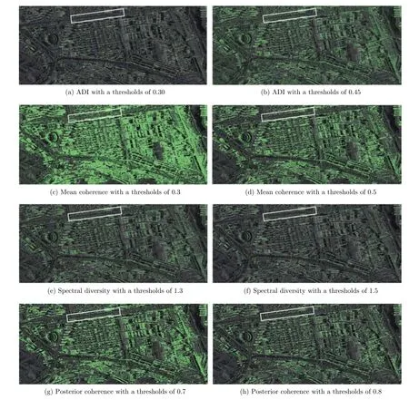
Fig.9 Examples of PS point selection with different criteria
3.2 Reliability of parameter estimation
During temporal phase unwrapping,the residual phase dispersion with respect to the assumed model,namely the ensemble phase coherence[13]or temporal coherence[83],is normally used to examine the correctness of parameter estimation on an arc.The research in Ref.[84]and Ref.[85]analyzed the advantages and limitations of temporal coherence as a reliability measure.The measure may help to achieve better temporal unwrapping but cannot identify errors in spatial unwrapping.The assumption of the phase residuals on an arc are smaller than π is only valid in high coherence areas with a moderate fringe rate.Urban structures generally remain highly coherent in SAR images and the high fringe rates related to the high buildings may not satisfy the assumption.
Efforts have been devoted to extracting correct deformation information in the presence of noisy observations with robust estimation algorithms,e.g.,L1norm estimator[86].It is also useful to develop approaches to detect and correct phase-unwrapping errors[87-92].For example,unwrapped phase closure of a triplet network in an interferometric network has been used to detect phase unwrapping errors since theoretically the closure should be 0[18,93,94].Unwrapping errors have been corrected based on the phase closure constraint[85,95].An example of an unwrapping error detection and correction on a road in Hong Kong is shown in Fig.10.Fig.10(a)and Fig.10(b)indicate the phase closure of wrapped and unwrapped interferogram triplets,respectively while Fig.10(c)shows the phase closure after the error correction.
3.3 Geolocation of PS points
In urban deformation monitoring,accurately geolocating the measured deformation is critically important,yet challenging due to the existence of many high-rise buildings.Several papers have devoted to analyzing the errors in geocoding[96-99]and found that it is more difficult to precisely retrieve the geolocation of measured points with the presence of atmospheric delays[100],orbital errors[41,101]and DEM errors[96].For example,the strong atmospheric delays in coastal areas and the small baseline variation of modern SAR images (e.g.,Sentinel-1)can result in large errors in building height estimation[102,103].Fig.11 shows an example of geolocating PS points with Sentinel-1 images in Hong Kong with scatterer heights retrieved from different estimators.Accurate geolocation is realized in Fig.11(a),while less accurate geolocation is achieved in the results shown in Fig.11(b).External data such as optical images and LiDAR datasets can also be used to help improve geolocation of measurement points and interpreting the results.
3.4 Line-of-sight measurements
InSAR deformation measurements are 1D essentially,reflecting deformation along the Line-Of-Sight (LOS)direction of the radar.In interpreting the measurement results from InSAR,assumption is often made.For example,in monitoring ground subsidence[20,104],it is often assumed that the observed deformation in the LOS direction is mainly due to vertical deformation.If the actual deformation is different from the assumed,incorrect conclusions may be derived.It is particularly important when monitoring deformation of infrastructures that often deform in 3D.When both ascending and descending SAR data are available,independent processing of the datasets and then analyzing the results jointly can offer 2D measurement results[105].There are also approaches for 3D deformation measurements with InSAR when the relevant data is available[106].Fig.12 shows the deformation near To Kwa Wan Subway Station in Hong Kong measured with TerraSAR-X (ascending)and COSMO-SkyMed(descending)datasets.The two sets of results have very different patterns,indicating that there is significant horizontal deformation in addition to the vertical deformation.
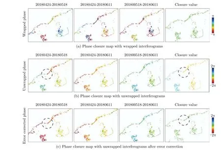
Fig.10 Phase closure of an interferogram triplet.The circle indicates where the unwrapping error occurred

Fig.11 Geolocation of PS points on a Google Earth image with height information estimated with different approaches

Fig.12 Deformation of To Kwa Wan Subway Station in Hong Kong estimated from TerraSAR-X and COSMO-SkyMed datasets
3.5 Areas in shadow
Many cities,especially those in Asia are constructing higher and higher buildings to accommodate the ever increasing population.For example,Hong Kong is one of the most densely populated cities in the World.When applying In-SAR techniques in such areas,the high-rise buildings can generate significant geometric distortions,e.g.,shadows that are unobservable by SAR sensors.Fig.13 shows a part of the Kowloon Peninsula in Hong Kong measured with TerraSARX.It can be seen from the SAR amplitude image in Fig.13(c)that many of the ground areas along the streets and many buildings are in the shadows of the tall buildings.Using data from multiple SAR platforms and multiple incidence angles may help to overcome the problem to certain extent but not completely.Therefore,when applying InSAR to study urban deformation,it is important to understand what is being observed.For example,if ground subsidence is to be monitored,simply monitoring the deformation of tall buildings may offer misleading information.
3.6 Processing of large SAR datasets
With the increasing number of operational SAR satellites and the abundant SAR images available,processing the large amount of SAR data sometimes becomes a bottle neck problem.For example,if all the available SAR data for a whole province in China,or even whole China is routinely processed to detect hazardous areas,then the hardware,software and data processing algorithms all need to be redesigned and optimized.This is particularly true if Near-Real-Time(NRT)results[107-109]are required.For example,distributed computing methods may become necessary[66].Sequential data processing models may be needed to handle the large volume of data[108-112].
3.7 Long time series of SAR images

Fig.13 An area in Kowloon Peninsula,Hong Kong
In general,the longer a time series of SAR images is used,the fewer coherent points there will be.This is understandable as the longer the data series becomes,the more chances there will be for a ground area to be disturbed.For example,Fig.14 shows three SAR images over the Hong Kong International Airport,acquired in 2007,2015 and 2018,respectively.The area in the dashed rectangle apparently has changed significantly over the time period.Therefore,unless a technique that allows temporarily coherent points[21,113]to be used,it would be very difficult to identify any coherent points in the area.
3.8 Quality control
Quality control of InSAR results has always been an important issue in InSAR applications although verification of InSAR results has been carried out many times[114,115].For example,there is a need to carry out more cross-comparison between the various existing MT-InSAR techniques(e.g.,[116])and develop better quality measures for MT-InSAR results and application standards so that InSAR results can be more standardized and uniform.

Fig.14 SAR images over Hong Kong International Airport acquired in 2007,2015,and 2018,respectively
4 Conclusions
MT-InSAR is one of the most powerful remote sensing technologies for measuring high-resolution ground deformation over large ground areas.There have been increasing research efforts on developing the capabilities of MT-InSAR over the past two decades as evidenced by the numbers of relevant publications and citations.MTInSAR techniques have been successfully applied to monitor various types of urban deformation,including ground subsidence,deformation of urban infrastructures,and deformation due to underground construction.MT-InSAR has become a mature technology that can be applied routinely to measure the deformation of single or groups of structures,part of a city,a whole city,part of a nation or a whole nation to identify areas that are unstable and potentially geohazardous.
Despite the great success in developing the MT-InSAR technology,there are still many challenges to overcome,including the inconsistency in the identified coherent points when different approaches or criteria are used,the reliability issues in parameter estimation,difficulties in accurate geolocation of measured points,the 1D line-ofsight nature of InSAR measurements of the technology,the effects of geometric distortions,the challenges in processing large SAR datasets,the decrease of coherent points with the increase of the length of a SAR time series,and the difficulty in quality control of MT-InSAR results.Apparently,these challenges all may impede to certain extent the widespread application of MT-In-SAR technology.Therefore,further research is required to overcome the issues.
