Analysis of the Land Use Structure in Alpine Valley Area of Jinsha River: Taking Xueshan Township, Luquan County, Yunnan Province as an Example
2019-12-17JiaWANGZishengYANG
Jia WANG, Zisheng YANG
Institute of Land & Resources and Sustainable Development, Yunnan University of Finance and Economics, Kunming 650221, China
Abstract Oriented by ecological, production and living functions of land, this paper analyzes the status of land use in Xueshan Township, Luquan County, Yunnan Province using the method of assignment. The land is classified into general production land, production and ecological land, general living land, living and production land, living and ecological land, general ecological land and ecological and production land. The result is compared with the classification system of the second national land survey. In theory, the classification system of ecological land, living land and production land is constructed. Taking Xueshan Township, Luquan County, a typical alpine valley area of Jinsha River as an example, based on the survey data on the changes of land use in Xueshan Township in Luquan County in 2016, this paper analyzes the distribution of ecological land, living land and production land in Xueshan Township. The results show that in Xueshan Township, ecological land (including general ecological land and ecological and production land) has the largest proportion (54.84%) in area, followed by production land (including general production land and production and ecological land) (44.41%), and living land (including general living land and living and production land) has the lowest proportion (only 0.75%). In overall, the distribution of production land and ecological land in Xueshan Township is not reasonable enough. For example, the proportion of dry land with a slope bigger than 15° and serious oil erosion in the township is currently 79.23%, among which, the dry land with a slope bigger than 25° and particularly serious soil erosion accounts for 52.88%. Therefore, it is necessary to gradually take measures to convert cultivated land into forests and further optimize the structure and spatial configuration of ecological land, living land and production land.
Key words Land use structure, Classification system, Land use classification, Alpine valley area of Jinsha River, Xueshan Township, Luquan County
1 Introduction
As China’s economic development enters a new phase, it objectively brings new opportunities and challenges to the land use discipline. The report of the 18th National Congress of the Communist Party of China proposes to build a space with intensive and efficient production space, livable and moderate living space, and beautiful ecological space[1], and puts forward the goals and principles of land space optimization. In China’s current classification system, land used is divided into three categories: agricultural land, construction land and unused land. This classification system pays full attention to the production and living functions of the land, pays attention to the contradiction between the protection of cultivated land and the allocation of construction land, but rarely consider ecological functions of land, thus neglecting the ecological imbalance that may be caused by land use[2]. In recent years, with the rapid development of population, economy and society, land use patterns, land use structure and spatial patterns have changed. As a result, the land use functions have undergone corresponding changes and successions, evolving from the initial production and living functions into production, living and ecological functions. The emergence of the land use classification system of production land, living land and ecological land is both an adjustment and a challenge. In recent years, the academic circles have formed three kinds of ideas for the classification study of production land, living land and ecological land[3]. First, based on the subjective land use intention of the behavioral subject, the leading function of land use is highlighted. The land used is divided into single functional types such as production land, living land, and ecological land[4-5]. Second, the leading and secondary functions of land use are both taken into account, and the land used is divided into composite land use types such as ecological land, ecological and production land, production and ecological land, living and production[6-8]. Third, based on the differences in primary and secondary strengths of land use functions, the land used is classified into total 12 categories,i.e., ecological land, semi-ecological land, vulnerable ecological land, non-ecological land, production land, semi-production land, vulnerable production land, non-production land, living land, semi-living land, vulnerable living land and non-living land[9]. The construction and use of the production land-living land-ecological land classification system can effectively coordinate ecological construction and farmland protection, make overall considerations for rational construction projects, agricultural production and residential land use, guide the ecological utilization of land, and coordinate production, life and ecological space.
Xueshan Township in Luquan Yi and Miao Autonomous County (referred to as Luquan County) in the typical alpine valley area of Jinsha River is taken as an example in this paper. The township has the geomorphological features of the alpine valley of Jinsha River. High mountains, steep slopes, deep valleys, more bends and difficult roads are the basic portrayal. The natural conditions here are poor, the land is barren, the ecology is fragile, the economy is backward, and the scale of construction land is small. Using the survey data about the changes in the land use of Luquan County in 2016, based on production, living and ecological space, this paper analyzes the land use structure of Xueshan Township, in order to provide a basic reference for the rational layout of land use in Xueshan Township.
2 Construction of classification systems for ecological land, living land and production land
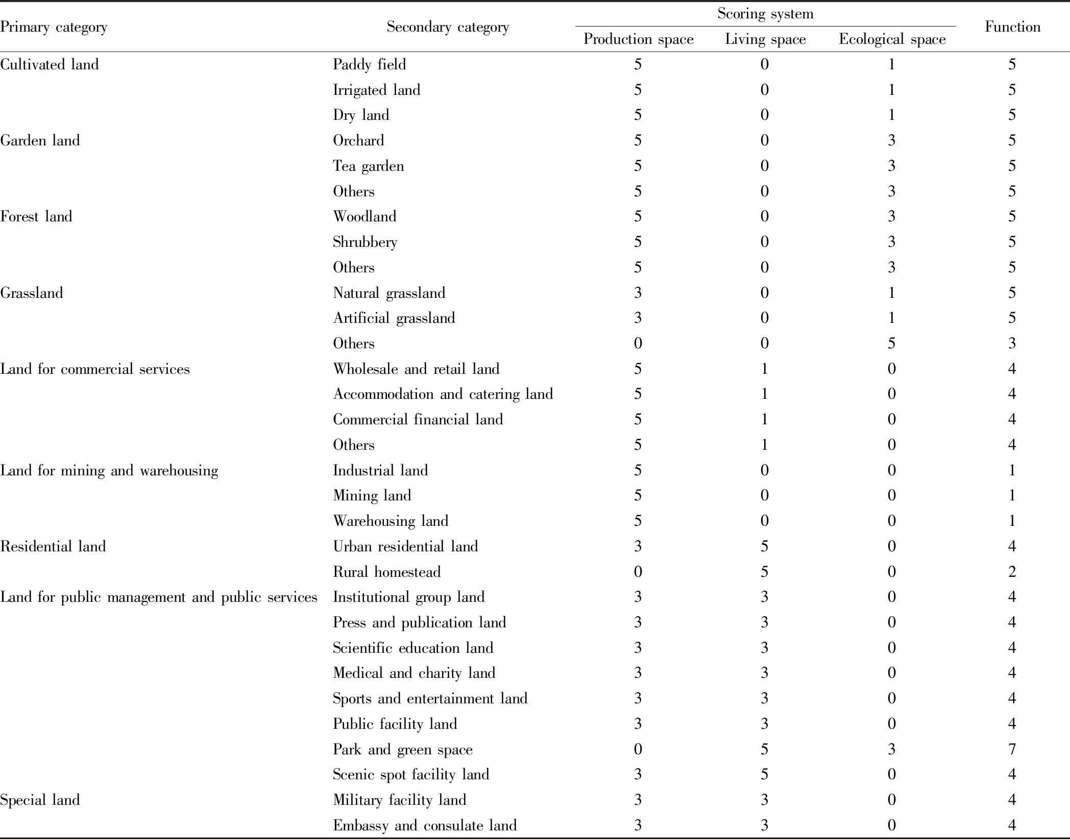
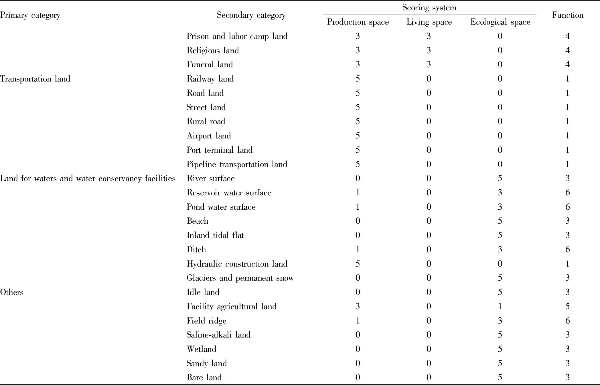
2.1 Construction methodThis paper adopts the assignment method proposed inClassificationevaluationandspatial-temporalanalysisofproduction-living-ecologicalspacesinChinaby Liu Jilaietal[9]. According to the second national survey of land use classification table, from the perspective of production-living-ecological land, the value of each land use type is assigned, and their functions are determined and classified. Versatility is the basic attribute of land resources. A piece of land can have multiple land use functions at the same time. When a piece of land is used as a type of land use, its function strength will also show differences. According to the differences in land function, Liu Jilaietal.[9]proposed a three-level assignment system to develop a production-living-ecological spatial evaluation system for land use types across China. Taking the land for living as an example, the values of living land, semi-living land, vulnerable living land and non-living land (lack of functions) are assigned as 5, 3, 1 and 0 point, respectively. Drawing on the classification method, the existing land use types are assigned one by one and divided into production land, living land, ecological land, production and living land, production and ecological land, living and ecological land and living and ecological land (Table 1).
Table 1 Classification, scoring system and functions of production land-living land-ecological land[9]
PrimarycategorySecondarycategoryScoringsystemProductionspaceLivingspaceEcologicalspaceFunctionCultivatedlandPaddyfield5015Irrigatedland5015Dryland5015GardenlandOrchard5035Teagarden5035Others5035ForestlandWoodland5035Shrubbery5035Others5035GrasslandNaturalgrassland3015Artificialgrassland3015Others0053LandforcommercialservicesWholesaleandretailland5104Accommodationandcateringland5104Commercialfinancialland5104Others5104LandforminingandwarehousingIndustrialland5001Miningland5001Warehousingland5001ResidentiallandUrbanresidentialland3504Ruralhomestead0502LandforpublicmanagementandpublicservicesInstitutionalgroupland3304Pressandpublicationland3304Scientificeducationland3304Medicalandcharityland3304Sportsandentertainmentland3304Publicfacilityland3304Parkandgreenspace0537Scenicspotfacilityland3504SpeciallandMilitaryfacilityland3304Embassyandconsulateland3304
(To be continued)
(Continued)
Note: In the column of "Function", "1" represents production land, "2" represents living land, "3" represents ecological land, "4" represents production and living land, "5" represents production and ecological land, "6" represents ecological and production land, and "7" represents living and ecological land.
2.2 Classification systems for ecological land, living land and production landBased on the above-mentioned assignment method of Liu Jilaietal, combined with the classification of land use status of the second national land survey, the production land-living land-ecological land classification system is established in this paper. First of all, according to the three main functions in the land use process, it is divided into production land, living land and ecological land. Second, in accordance with coordinating the leading and secondary functions of land use, the production land, living land and ecological land is further divided.
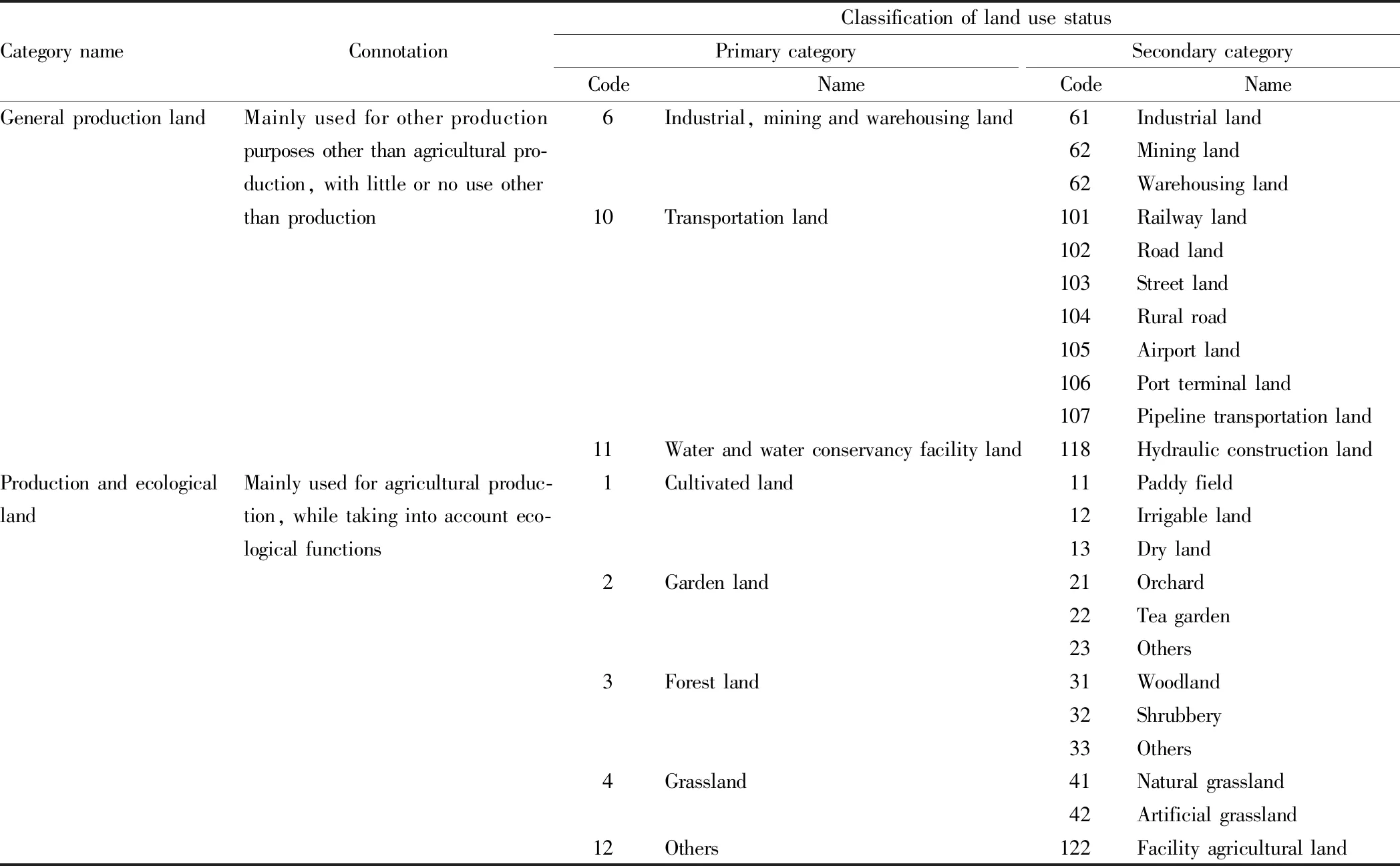
2.2.1Classification system for production land. Production land refers to the land directly or indirectly used for social production for people’s pursuit of various products and services[10]. Under the premise of considering the versatility of land use and highlighting the main function of land, the production land is further subdivided into general production land and production and ecological land. General production land refers to land that is used solely for the production of products and services, and it has little or almost no use other than production use, such as railway land, road land, street land, rural roads, airport land, port terminal land and pipeline transportation land that directly or indirectly provides people with many products and services, and belongs to important production land. Production and ecological land refers to land that is mainly used for agricultural production and has ecological functions. For example, paddy fields and irrigated land in arable land, orchards and tea gardens play an important ecological role and function while being used for agricultural production. The specific classification system of production land is shown in Table 2.
2.2.2Classification system for living land. Land for living refers to land that is used by people for living, rest, recreation, science, education, culture and health and some special purposes[11]. This paper divides it into general living land, living and production land and living and ecological land. For example, rural settlements are places where people live and rest, and are typical living land. Living and production land refers to land that provides both people’s living places and productive functions, mainly referring to urban residential land with both residential area and entertainment and shopping malls, as well as land for commercial services, public management, public services and special purposes. The living and ecological land is more special. In the entire classification system, only parks and green spaces have both living and ecological functions. The classification system for living land is shown in Table 3.
2.2.3Classification system for ecological land. At present, the academic circles have different opinions on the connotation of ecological land, and there is no clear and unified conclusion. Ecological land is not proposed as an independent land use type. Ecological land is land that promotes the sustainable use of land resources and maintains ecosystem stability with certain ecological regulation and restoration functions[11]. According to the diversity of land use functions, in this paper, ecological land is divided into two types: general ecological land and ecological and production land. General ecological land refers to land that is less impacted by humans and has the functions of regulating the atmosphere, conserving water, maintaining water and soil and protecting biodiversity. It mainly includes river surface, beaches and inland tidal flats in grassland, water area and water conservancy facilities, as well as glaciers and permanent snow, idle land in other land use types, saline-alkali land, marshes, sandy land and bare land. Most of them cannot be used for production and life, and they all belong to relatively complete ecological land. Ecological and production land refers to the land has both important ecological function and certain production function, but the ecological function is greater than the production function. Such land includes reservoir water surface, pond water surface and ditches in the land for reservoirs and water conservancy facilities, and it is commonly used for ecological protection and can be used for carrying out some production activities. The specific classification system for ecological land is shown in Table 4.
Table 2 Classification system for production land and classification of land use status (based on second national land survey)
CategorynameConnotationClassificationoflandusestatusPrimarycategoryCodeNameSecondarycategoryCodeNameGeneralproductionlandMainlyusedforotherproduction6Industrial,miningandwarehousingland61Industriallandpurposesotherthanagriculturalpro-62Mininglandduction,withlittleornouseother62Warehousinglandthanproduction10Transportationland101Railwayland102Roadland103Streetland104Ruralroad105Airportland106Portterminalland107Pipelinetransportationland11Waterandwaterconservancyfacilityland118HydraulicconstructionlandProductionandecologicalMainlyusedforagriculturalproduc-1Cultivatedland11Paddyfieldlandtion,whiletakingintoaccounteco-12Irrigablelandlogicalfunctions13Dryland2Gardenland21Orchard22Teagarden23Others3Forestland31Woodland32Shrubbery33Others4Grassland41Naturalgrassland42Artificialgrassland12Others122Facilityagriculturalland
Table 3 Classification system for living land and classification of land use status (based on second national land survey)
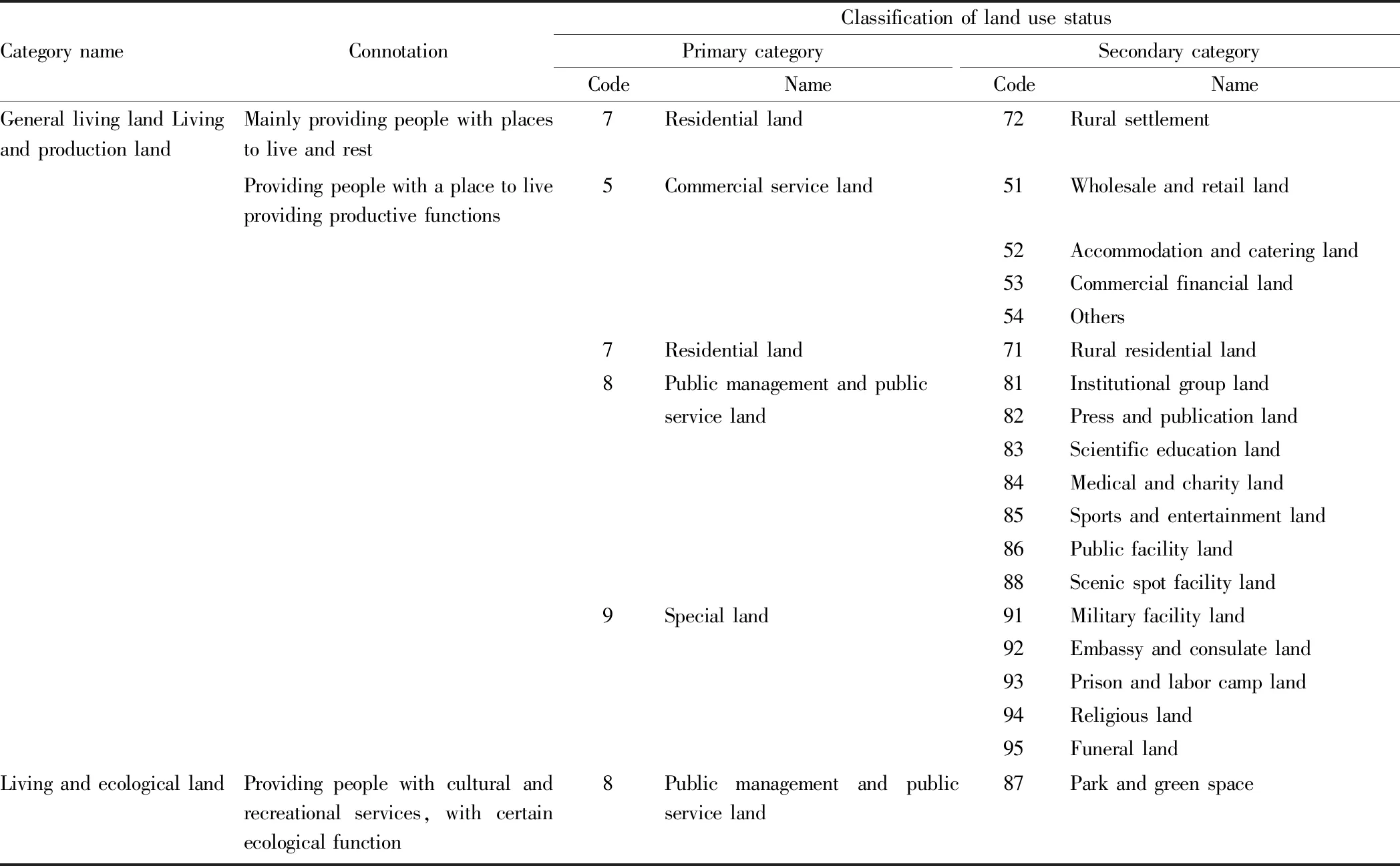
CategorynameConnotationClassificationoflandusestatusPrimarycategoryCodeNameSecondarycategoryCodeNameGenerallivinglandLivingandproductionlandMainlyprovidingpeoplewithplacestoliveandrest7Residentialland72RuralsettlementProvidingpeoplewithaplacetoliveprovidingproductivefunctions5Commercialserviceland51Wholesaleandretailland52Accommodationandcateringland53Commercialfinancialland54Others7Residentialland71Ruralresidentialland8Publicmanagementandpublic81Institutionalgrouplandserviceland82Pressandpublicationland83Scientificeducationland84Medicalandcharityland85Sportsandentertainmentland86Publicfacilityland88Scenicspotfacilityland9Specialland91Militaryfacilityland92Embassyandconsulateland93Prisonandlaborcampland94Religiousland95FunerallandLivingandecologicallandProvidingpeoplewithculturalandrecreationalservices,withcertainecologicalfunction8Publicmanagementandpublicserviceland87Parkandgreenspace
Table 4 Classification system for ecological land and classification of land use status (Based on second national land survey)
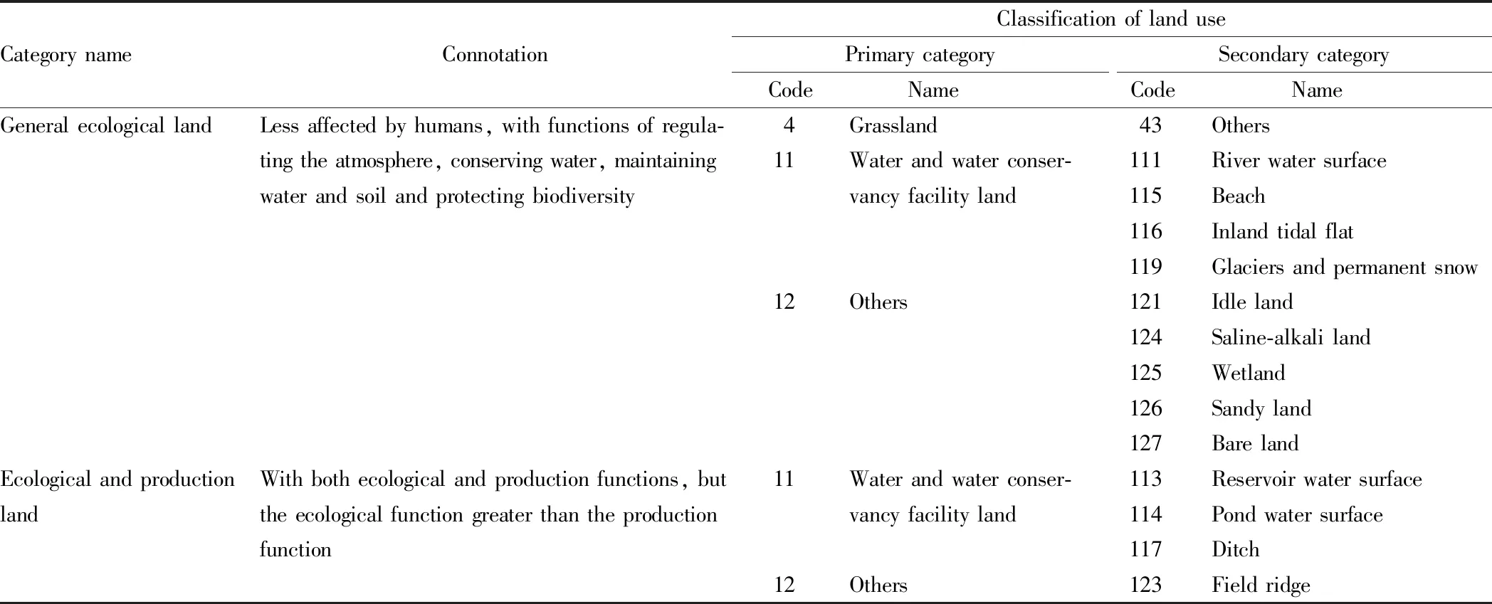
CategorynameConnotationClassificationoflandusePrimarycategoryCodeName SecondarycategoryCode Name GeneralecologicallandLessaffectedbyhumans,withfunctionsofregula-4Grassland43Otherstingtheatmosphere,conservingwater,maintaining11Waterandwaterconser-111Riverwatersurfacewaterandsoilandprotectingbiodiversityvancyfacilityland115Beach116Inlandtidalflat119Glaciersandpermanentsnow12Others121Idleland124Saline-alkaliland125Wetland126Sandyland127BarelandEcologicalandproductionWithbothecologicalandproductionfunctions,but11Waterandwaterconser-113Reservoirwatersurfacelandtheecologicalfunctiongreaterthantheproductionvancyfacilityland114Pondwatersurfacefunction117Ditch12Others123Fieldridge
3 Research area and data source
3.1 Overview of research areaLuquan Yi and Miao Autonomous County is one of the remote suburban counties of Kunming City, Yunnan Province. It is a national poverty-stricken county. Xueshan Township is a township under the jurisdiction of Luquan Yi and Miao Autonomous County. The township is located in the alpine valley of Jinsha River in the southwest of China, with maximum elevation of 4 247 m and lowest elevation of 794 m (i.e. altitude difference reaches 3 453 m). The land area in Xueshan Township is 133.14 km2. The terrain in Xueshan Township is complex and diverse. The Pudu River flows from the south to the north and flows into the Jinsha River. Due to the great difference in altitude, the natural conditions are extremely harsh, the land is barren, and economic development is very backward, leading to high incidence of poverty in rural areas. There are 3 422 households in Xueshan Township, with an agricultural population of 12 527. The seven village under the jurisdiction of the township, including Hayi, Tuomuni, Shugu, Fengzu, Jiduo, Shicheng and Lewu, are all poor villages, of which five villages are extreme poverty-stricken villages[12].
3.2 Source of dataThe data used in this analysis is derived from the Luquan Statistical Yearbook 2017 and the survey data about the changes in the land use of Xueshan Township, Luquan County in 2016. The land use types include 8 primary and 21 secondary categories such as cultivated land, garden land, forest land, grassland, water area, land for water conservancy facilities, transportation land and other land use.
4 Analysis of land use structure and existing problems
4.1 Land use structureIn terms of land use structure, Xueshan Township of Luquan County covers six types of land, namely general production land, production and ecological land, general living land, living and production land, general ecological land and ecological and production land, of which the area percentages are 0.58%, 43.83%, 0.74%, 0.01%, 50.18% and 4.67%, respectively. General production land includes mining land, road land, rural roads, and hydraulic construction land, of which rural roads account for the majority. General living land is mainly village land that does not have industrial production capacity. The area percentage of general ecological land is the largest and is dominated by "other grasslands". The production and ecological land is mainly composed of forest land and shrubbery land. The area proportion of living and production land is the smallest, dominated by land for scenic spot facilities. The ecological and production land is mainly reservoir water surface, pond water surface, ditches and field ridges.
As can be seen from the above analysis, the proportion of ecological land in Xueshan Township (including general ecological land and ecological and production land) is 54.84%, which exceeds 1/2 of the total land area; the proportion of living land (including general living land and living and production land) is the smallest, only 0.75%, which fully demonstrates the characteristics of the typical alpine valley area of Jinshan River, that is, high mountain, steep slope, cliff and deep valley; and the area percentage of production land (including general production land and production and ecological land) is second only to ecological land, which is 44.41%. It indicates that Xueshan Township is mainly based on agricultural production (Table 5).
Table 5 Structure of production land-living land-ecological land in the village committees of Xueshan Townshipha

VillagecommitteeTotallandareaProductionlandGeneralproductionlandProductionandecologicallandTotalLivinglandGenerallivinglandLivingandproductionlandTotalEcologicallandGeneralecologicallandEcologicalandproductionlandTotalHayiVillage1672.288.52731.42739.9410.15010.15854.6067.58922.19TuomuniVillage1182.179.58614.59624.1613.68013.68490.4153.91544.32ShuguVillage2111.0210.671432.761443.4318.470.0818.55558.6090.43649.03FengzuVillage1207.7610.83423.74434.5712.80012.80638.28122.10760.38LewuVillage1234.043.41629.95633.367.5307.53543.5949.55593.14ShichengVillage1852.5015.28476.28491.5616.610.5017.111256.2487.591343.83JiduoVillage2394.2119.40670.72690.1219.300.1119.411534.73149.951684.68Foreststation1660.010856.17856.17000803.840803.84Total13313.9877.685835.645913.3298.550.6999.236680.31621.127301.43
4.2 Existing problems in land use structureThe western mountainous area is the upper reaches of many large rivers, and it belongs to China’s important ecological security barrier. But in many river basins, the phenomenon of cultivation on steep slopes is still relatively common, causing serious consequences such as soil erosion and ecological damage. According to theLawofthePeople’sRepublicofChinaonWaterandSoilConservation, steep slopes that are not suitable for cultivation should be converted into forests. Developing the economic forestry and fruit industry by converting cultivated land to forests can not only protect the ecological environment but also make people in mountainous areas increase their incomes. Especially in Xueshan Township, an alpine valley area of Jinsha River, the phenomenon of cultivation on steep slopes is still common. According to the survey data about the changes in land use in Luquan County in 2016, currently, the proportion of dry land with slope above 15° and serious soil erosion in the township is more than 79.23%, of which the dry land with slope above 25° and particularly serious soil erosion accounts for 52.88% of the total cultivated land (Table 6). This shows that the distribution structure of production land and ecological land in Xueshan Township is not reasonable enough. In particular, the proportion of dry land with slope bigger than 25° exceeds 1/2 of the total cultivated land. Measures to convert cultivated land into forests should be taken gradually. Therefore, further optimizing the structure and spatial configuration of production land-living land-ecological land has become a major task for the next ecological construction and rural revitalization strategy of Xueshan Township and even the entire alpine valley of Jinsha River.
Table 6 Area of cultivated land of different slope in the village committees of Xueshan Townshipha
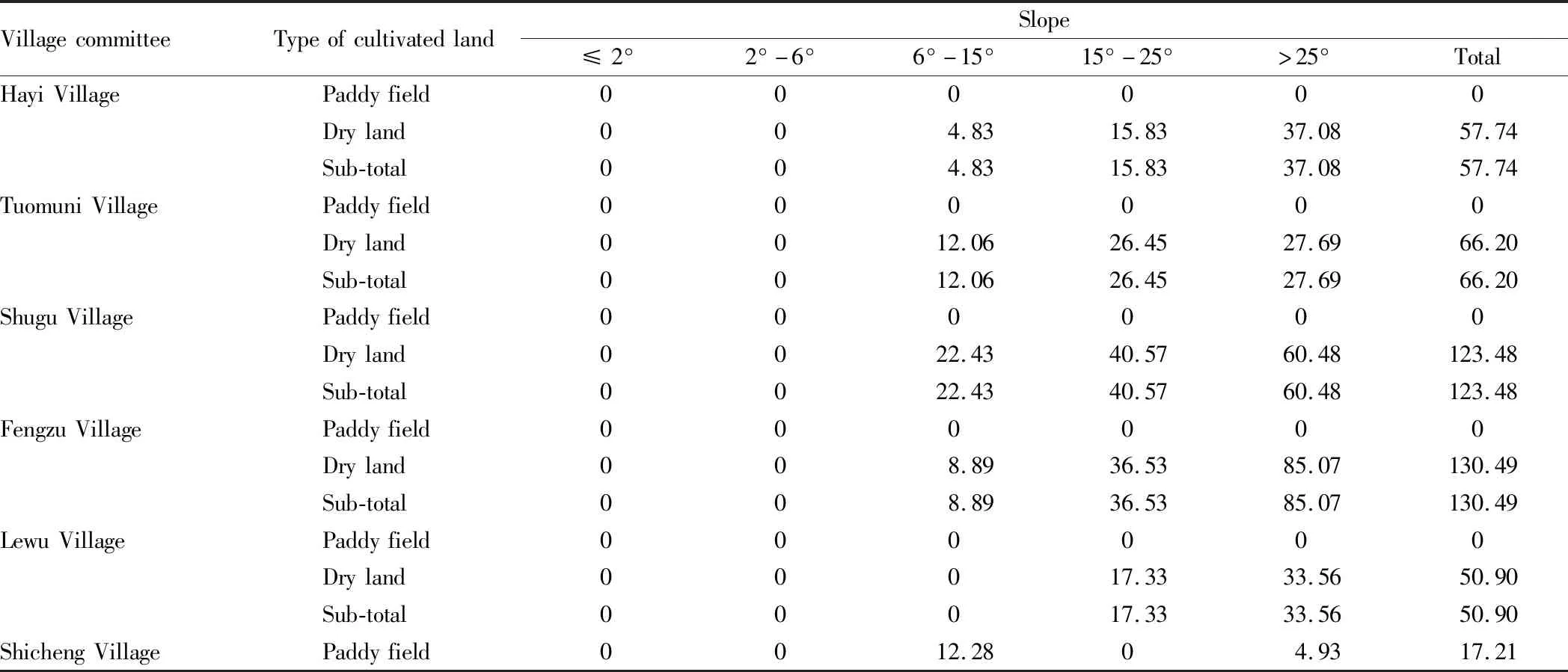
VillagecommitteeTypeofcultivatedlandSlope≤2°2°-6°6°-15°15°-25°>25°TotalHayiVillagePaddyfield000000Dryland004.8315.8337.0857.74Sub-total004.8315.8337.0857.74TuomuniVillagePaddyfield000000Dryland0012.0626.4527.6966.20Sub-total0012.0626.4527.6966.20ShuguVillagePaddyfield000000Dryland0022.4340.5760.48123.48Sub-total0022.4340.5760.48123.48FengzuVillagePaddyfield000000Dryland008.8936.5385.07130.49Sub-total008.8936.5385.07130.49LewuVillagePaddyfield000000Dryland00017.3333.5650.90Sub-total00017.3333.5650.90ShichengVillagePaddyfield0012.2804.9317.21
(To be continued)
(Continued)

VillagecommitteeTypeofcultivatedlandSlope≤2°2°-6°6°-15°15°-25°>25°TotalDryland001.1419.0558.2078.39Sub-total0013.4219.0563.1395.60JiduoVillagePaddyfield0013.903.921.9319.75Dryland0058.3527.8366.25152.43Sub-total0072.2431.7568.18172.17TotalPaddyfield0026.183.926.8636.96Dryland00107.70183.60368.33659.63Sub-total00133.88187.51375.19696.58
5 Conclusions
This paper theoretically constructed the classification system for production land-living land-ecological land. Taking Xueshan Township, Luquan County, a typical alpine valley area of Jinsha River as an example, according to the survey data of changes in land use status, the structure of land use was analyzed, and it was concluded that the three types of land ranked as ecological land > production land > living land in terms of size of area. According to the analysis on the area proportion of cultivated slope of different slope, it was found that the use structure of production land and ecological land in Xueshan Township is not reasonable, so it is urgency for Xueshan Township to further optimize the structure and spatial layout of production land-living land-ecological land, in order to rationally utilize every inch of land, vigorously improve land use efficiency, and serve the rural revitalization strategy. Based on the structure of production land-living land-ecological land in the seven villages of Xueshan Township, Luquan County, the following three suggestions are put forward.
First, oriented by the planning of production land, the prime cropland preservation area should be refined and re-divided, and the creation of high-standard prime cropland should be accelerated to ensure food security and specialty crop production. At the same time, characteristic industries should be developed, and rural characteristic brands should be built, to achieve the goal of getting rich in the countryside and increasing the income of farmers.
Second, focusing on the rational layout and intensive use of living land, the internal planning and construction of rural markets and rural residential areas should be improved comprehensively, and the construction of rural roads and greening systems should be increased appropriately to improve the quality of life of farmers, and build a beautiful countryside in the mountainous area.
Third, based on the planning of ecological land, steep slopes that are not suitable for production should be converted into ecological land, and efforts should be made to increase ecological construction, to lay a solid ecological environment foundation for rural sustainable development.
杂志排行
Asian Agricultural Research的其它文章
- Application Effects of Stabilized Fertilizer with Reduced Amount and Frequency on Rice
- Characteristics of Changes in Energy Consumption of Rural Residential Buildings from the Perspective of Province and Recommendations
- Contents of Heavy Metals in Typical Aquatic Products from a Market in Binzhou
- Assessment on Ecological Capital of Small Towns: A Case Study of Baita Town, Weifang
- Yield Gap Analysis of Wheat in Rice-wheat Rotation Regions of Anhui Province, China
- Effects of Different Storage Temperatures on Shelf Life and Quality of Strawberry Fruit after Hot Water Treatment
