A preliminary study on the theory and method of comprehensive regionalization of cryospheric services
2019-08-13LINHaoXiHUANGJinChuanFANGChuangLinQIXiaoXiaoCHENYunQian
LIN Hao-Xi, HUANG Jin-Chuan,*, FANG Chuang-Lin, QI Xiao-Xiao,CHEN Yun-Qian
a Institute of Geographic Sciences and Natural Resources Research, Chinese Academy of Sciences, Beijing, 100101, China
b Key Laboratory of Regional Sustainable Development Modeling, Chinese Academy of Sciences, Beijing, 100101, China
c College of Resources and Environment, University of Chinese Academy of Sciences, Beijing, 100049, China
d Beijing National Day School, Beijing, 100039, China
Abstract As one of the five most important spheres affecting climate systems globally, the cryosphere not only exerts crucial impacts on natural environment,but also plays a key role in guaranteeing the goods and services provision of the oasis in the cold and arid regions.However,there is a lack of synthesized knowledge about the contributions and profitability on socio-economic aspects of the cryospheric services(CSs).To cope with this key and urgent sustainable development issues, this study constructs a comprehensive regionalization research system that integrates the natural and socio-economic aspects for cryospheric characteristics with emphasis on interdisciplinary approaches. Guided by the supplydemand equilibrium model and the service maximization model, the research system consists of establishing a classification system for CSs,identifying the spatial distribution pattern of CSs,and constructing the comprehensive regionalization of CSs,which finally divides the research area into relatively independent, complete, and organically linked CS units of multiple spatial levels. By setting up a bridge between the CSs with socio-economic needs, it has profound and practical significance and implications for implementing the sustainable utilization strategies and macroeconomic policymaking for global environmental protection.
Keywords: Principle; Method; Service; Comprehensive regionalization; Cryosphere
1. Introduction
As an integral part of the climate system, the cryosphere refers to the negative temperature layer of the Earth's surface,which stores 75% of the Earth's freshwater in the form of a solid water reservoir. The major constituent elements are glaciers, frozen ground, snow cover, frozen precipitation, sea ice, river ice, and lake ice (IPCC, 2013). Through complex positive and negative feedbacks such as water, energy, and material exchange, it interacts strongly with the atmosphere,biosphere,hydrosphere,and lithosphere(Barry and Gan,2011;Marshall, 2011). The cryosphere is the material and cultural basis for the sustainable development of the environment,society, and economy in high latitude and altitude regions,which collectively lay a solid foundation for multiple services or benefits that the cryosphere can provide to humans,namely cryospheric services (CSs), such as the freshwater resources provision,ecological regulation and so forth(Qin et al.,2006;Qin and Ding, 2010).
However, previously, cryospheric science mainly focused on natural properties and negative socio-economic impacts,including processes and mechanisms of cryospheric changes,disasters as well as vulnerability (Zhang and Wu, 2012; Yang et al.,2015;Qin et al.,2018).A case in point is that a number of studies have documented the extent of climate change in various parts of the world and the impact of this change on glaciers(Yao et al.,2012),river flows(Immerzeel et al.,2012),and to some extent snow and permafrost (Gao et al., 2016).While our knowledge about the physical basis of cryospheric change has expanded considerably in recent years, there has been lack of systematic research and discussion in the fields such as value assessment, categorization, regionalization of CSs and their direct impacts on human well-being, which has led to a gap in theory research and practice application between the cryospheric sciences and socio-economic development, with limited guidance for bridging this gap.
Given this knowledge gap, the CSs have not received sufficient attention due both to relatively remote location and to lack of public awareness, though some work has already been carried out on the impacts of cryospheric changes on human societies, where basins, like the Indus, were identified to be more critically dependent on ice,snow,and glaciers than other basins (Kaser et al., 2010). However, much of this body of work has focused on the downstream impacts in the plains(Moors and Stoffel,2013; Nepal et al., 2014), leaving us with less understanding about the contributions of the cryosphere to high mountain communities such as the Hindu Kush Himalaya(Mukherji et al., 2019). In recent years, there has been a rekindling of interest in linking cryosphere research with societal needs(Qin et al.,2018).One of the outcomes of this has been the emergence of the applied concept of a cryosphere service function framework (Xiao et al., 2015), largely adapted from the concept of ecosystem services.
The convergence of cryospheric-socio-economics is not only an inevitable trend, but also an indispensable requirement for enhancing the applicable value and satisfying major national strategic needs(Qin et al.,2006;IPCC,2013).From a scientific point, bridging the supply side of CSs and the demand side of socio-economic needs would make important theoretical contributions to theory of man-land territorial system and sustainable development(Qin et al.,2018).From a practical point, breakthroughs in exploring the territorial differentiation rules of CSs is beneficial to revealing the mechanism behind the cryospheric process and its services dealing with major issues such as sea level rise and marine resource exploitation caused by climate changes (Fountain et al., 2012; Hodson et al., 2015), as well as providing scientific support for the “Belt and Road” initiative and Winter Olympics preparation.
Correspondingly,as the value of CSs is becoming more and more prominent, it is necessary to have a full scientific understanding of their spatial differentiations, complex diversities, and various characteristics, to lay a scientific and strategic foundation for identifying the regional similarities and differences of CSs. To cope with this key and urgent scientific issues, this study aims at constructing a comprehensive regionalization research system that integrates the natural and socio-economic aspects for cryospheric characteristics with emphasis on interdisciplinary approaches,which belongs within the overall framework of the Earth's system(Hinzman et al., 2005; Liu et al., 2007).
2. Theoretical analysis
2.1. Concept, definition, and scale
As shown in Fig. 1, cryospheric function (CF) focuses on natural attributes, which form the premise, foundation, and material guarantee for CSs. Based on human needs and preferences, CSs are produced by the CFs, specifically, the needs of human livelihood and overall well-being. To be specific,CSs are defined as all benefits directly or indirectly obtained from the cryosphere, including all products and services contributing to human survival and life quality (Qin et al.,2017). The definition of CSs can be extended to the formation process of various cryospheric benefits to the hydrosphere,atmosphere,biosphere,and lithosphere.CSs bridge the gap between the natural environment and socio-economic development (Kang et al., 2010). Rooted in the hierarchical organization and complexity of the Earth's surface,there exist three dimensions in the comprehensive regionalization of CSs.First, the spatial scale, which refers to the spatial extent of changes in things or phenomena, including grid, administrative division,watershed,region,nation,and globe.Second,the time scale,which refers to the specific time period of changes in things or phenomena and the time length of adaptation,including the status quo, near-term, medium-term, etc. Third,the links between CSs and human well-being,and who serves,what services are involved, and how to serve stakeholders,whether they be individuals,family,community,enterprise,or government.
Comprehensive regionalization is a method of expressing the regional distribution law of geographical phenomena and their characteristics, which intuitively expresses the attributes and interconnections of various components in the geographical environment. Furthermore, comprehensive regionalization contributes to an understanding of the geographical laws of CSs occurrence, development, distribution, structure, etc. Specifically, comprehensive regionalization is the basic approach to perceive the world geographically both in terms of theory and practice.Generally, a certain region is divided into a number of spatially conjugated regions with intra-regional similarities and significant inter-regional differences (Bailey, 1983; Wu et al., 2016). Cross-complementary interdisciplinary methods, multi-source and heterogeneous data support, and the combination of qualitative and quantitative methods are the main features of comprehensive regionalization (Shi et al., 2014). The top-down sequential division method and the bottom-up stepwise merging method are two basic types of comprehensive regionalization. The former can objectively grasp and reflect the general law of geographical differentiation, which is suitable for determining the boundaries of high and intermediate regionalized units. The latter combines the regions with similarities based on the lowest regionalized units. The combination of the abovenamed methods has become the new standard in current comprehensive regionalization.
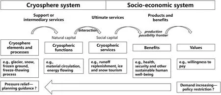
Fig. 1. The differences and similarities between cryospheric function and cryospheric service.
2.2. Theoretical basis and principle
Principally,the rule of territorial differentiation is the basic theoretical basis of all regionalization.The spatial distribution of natural and human geographical elements is interrelated and mutually influential; they act together on territorial differentiation (Fang et al., 2017). Thus, comprehensive regionalization is based primarily on intrinsic similarities and regional differences determined by the rule of territorial differentiation(Hartshorne, 1997). At the same time, the cryosphere is a symbiotic system in which population, economy, society, resources, ecology, and environment are interdependent. CSs organically couple natural elements with human needs, and a dynamic structure is formed in which man and land interact with each other in the specific region of the cryosphere. How to draw on advantages and avoid disadvantages on the basis of the man-land territorial system theory in the cryosphere has become a key issue for sustainable development. Moreover,the theory of environmental and resource capacity provides the theoretical foundation for evaluating the carrying capacity of CSs. The set theory, information theory, and coding theory directly provide guidance for formulating the scheme for comprehensive regionalization of CSs. Multi-dimensional research must be carried out using a comprehensive perspective of the natural-economic-social composite system theory.
The rational and practical principles are keys to the success of comprehensive regionalization (Zheng et al., 2008). In consideration of the natural characteristics of the cryosphere,and the occurrence, development, and connection of CSs, the principles of comprehensive regionalization of CSs are listed as follows:
(1) The principle of occurrence. The formation of the cryosphere is closely related to human survival. Therefore, the synergy and trade-off relationship among CSs is a product of historical development and will continue to affect global climate change.
(2) The principle of the grading system. The regional differences revealed by different regionalization grades must be consistent or maintain a logical relationship including sequential order and importance logic, thus forming a hierarchy that reflects the territorial differentiation of CSs.
(3) The principle of multi-scale integration. The watershed zoning, administrative division, and grid are defined as the main scale units. Also, point elements (e.g., city distribution), line elements (e.g., river), and surface elements (e.g., alpine grassland) are determined as the cross-scale units. Through a combination of different scale units, this study intends to achieve multi-scale integration.
(4) The principle of relative consistency. For any regionalization unit of CSs, the similarities within the unit and the inter-regional differences should be as large as possible. Also, the fragmented regions should be appropriately combined in accordance with the principle of area ratio first, fully reflecting the regularity and integrity of regional differentiation.
(5) The principle of integrity and dominance. It is noteworthy that comprehensively considering the factors affecting the territorial differentiation of CSs and seizing the major factors are the main ways for strengthening scientific soundness and effectiveness.
2.3. Theoretical model
2.3.1. The supply-demand equilibrium model
The formation and evolution of the cryosphere is driven by the combination of natural elements and human activities.The leading role of human activities in typical regions is becoming increasingly clear, and this is profoundly affecting the key elements of the natural regional system and its mechanisms of interaction (Kahn, 2016). Comprehensive regionalization in the current era should pay more attention to the factors, patterns, and processes in the human-natural coupling effect on multiple scales. As a result, this study integrates human and natural elements into the indicator system.Supply and demand are important prerequisites for services. The supply of CSs refers to the human products and services provided by the cryosphere.The demand of CSs refers to the consumption and use of cryospheric products and services by humans. The termination of CSs is where service reductions generate effects. Supply and demand together constitute the dynamic process of CSs flowing from the natural-ecological compound system to the economic-social compound system. In light of the Integrated Valuation of Ecosystem Services and Trade-offs model (InVEST model) and the Artificial Intelligence for Ecosystem Services (ARIES model), the InVEST model follows the primary logic of“Supply-Service-Value,”while the ARIES model applies “Supply-Demand-Sink” as the conceptual framework. For the InVEST model, supply is the product or function that the cryosphere can potentially provide and is transformed into services by the beneficiary's needs and utilization. Moreover, social preferences are incorporated in order to represent the value of those services with socioeconomic indicators. For ARIES model, the spatial flow of services is conveyed by transfer media. During the flow process, all effects leading to weakening of the transfer media is collectively referred to as the “sink”, as shown in Fig. 2. A“sink” can weaken the service while enhancing the protective service (Nelson et al., 2009). Identifying the supply area and assessing the supply potential of CSs are the basis of adopting effective management and appropriate development to meet the growing social and economic needs. Clarifying the spatial distribution and structure on the demand side of CSs is conducive to exploring the promotions of and constraints on socio-economic development caused by CSs (Ostrom, 2009;Yang et al., 2016).
2.3.2. The service maximization model
For a given geographical region, the comprehensive development status of CSs is composed of economic development, social security, ecological protection, etc. The spatial equilibrium of CSs means that the per capita value of the comprehensive development status of each region tends to be balanced. Only in this way can CSs exist and play a role sustainably. In detail, the utilization of CSs will not only consider whether the various kinds of services have produced their greatest benefits,but also consider whether the maximum benefits they generate are greater than benefits that other combinations of CSs can produce. Correspondingly, the constraining conditions include carrying capacity and cost of implementation(Costanza,1997).All in all,human beings can enjoy CSs to a large extent only if CSs will be in their appropriate place and perform their corresponding duties,which realizes orderly spatial development.
2.4. Attributes of the regionalization
In terms of hierarchical attributes, regionalization is the organic coordinated unification of classification and division.Zheng(1998)divided regionalization into type regionalization and region regionalization according to use of the deductive method. Huang (1958) believed that each unit of region regionalization was adjacent geographically and maintained spatial unrepeatability, while each unit of type regionalization was allowed to be isolated from one another and maintain spatial repeatability. The difference between type regionalization and region regionalization lies in whether the spatial conjugation is followed or not. Accordingly, similar to majorfunction-oriented zoning and ecological function zoning, the comprehensive regionalization of CSs belongs to type regionalization; thus, each unit maintains spatial repeatability and isolation.
In terms of content attributes, the comprehensive regionalization of CSs is based on the spatial and temporal heterogeneity rules of cryospheric elements and is oriented toward socio-economic development needs. This identifies the spatial distribution of realistic differentiation and potential differentiation of CSs,which is also restricted by resource and environment carrying capacity, ecological red line, and so forth. Different from the physical geographic regionalization based on characteristics of the natural ecosystems and the regionalization of human geography focused on regional differences in human phenomena, the comprehensive regionalization of CSs conforms to the laws of physical geography and serves socio-economic development. This points to the specific functional regionalization of cryospheric resource protection, development, and utilization.

Fig. 2. The supply-demand relationship between natural and human systems.
3. Methodology
3.1. General technical process
First, this study establishes a classification system for CSs after exploring its theoretical foundation and defining its conceptual connotation. Second, with the supply and demand equilibrium model and the service maximization model as theoretical guidance, the spatial distribution pattern of CSs is determined by means of single and major service identification. Furthermore, based on the rule of territorial differentiation of the “man-land territorial system” in the cryosphere, as well as the principles of comprehensiveness, dominance, and integrity,the comprehensive regionalization of CSs is made in accordance with the supply side of CSs and the demand side of socio-economic needs. As a result, the comprehensive regionalization of CSs divides the cryospheric region into relatively independent and complete units with multiple spatial levels and organic links, as shown in Fig. 3.
3.2. Establishing a classification system for cryospheric services
Guided by the“man-land territorial system”and focused on cryospheric characteristics, this study establishes a classification system for CSs from the perspective of land use function,ecosystem service function,landscape ecological function,and the unique socio-economic services of the cryosphere (Yang et al., 2012; Costanza et al., 2014). The system consists of three main categories, 16 sub-categories, and 40 minorcategories, as shown in Table 1 and Fig. 4.
Basic ecological services refer to the services provided by the cryosphere that are beneficial for human survival. As primitive and natural services that are unique to the natural system, basic ecological services have been preserved after thousands of years of impacts from human activities, which play a key role in the ecological security guarantee and quality assurance of socio-economic development.
Primary production services refer to the transformation and utilization of the natural system by human beings initially,while such services still have strong dependence on natural systems,which act as the material security of socio-economic development.
Human development services refer to the fact that human beings obtain a basic survival guarantee via basic ecological services and primary production services. Human beings pursue more diverse functions and greater satisfaction when rid of various kinds of constraints.Hence,human development services are the most important source of human wealth creation.
According to the classification system for CSs, this study constructs an indicator system and data base for the comprehensive regionalization of CSs from three aspects of natural ecological conditions, cryospheric resource elements, and socio-economic attributes.From another perspective,this data base is a data cube composed of time, space, and attributes.
3.3. Identifying the single cryospheric service
After carefully evaluating the importance of various kinds of CSs by means of the supply and demand equilibrium model,the spatial distribution of a single CS importance (G) is identified as:

where S represents the importance evaluation of the supply side, D represents the importance evaluation of the demand side, and r is the amendment of the importance evaluation.
The importance evaluation of the supply side is based on the characteristics and practical needs of each CS, which corresponds to different combinations of the indicator system.The evaluation method is mainly supported by the weighted layer superposition and is supplemented by the group of services value quantization functions. By vertical and horizontal comparison, the results of the importance evaluation of the supply side are determined.
The importance evaluation of the demand side is to assess the degree of dependence of human activities on CSs and the cryospheric vulnerability degree, aiming at reflecting the degree of influence of human development and utilization on the cryosphere. In other words, as the importance of the supply side is constrained by resource and environment carrying capacity, there inevitably exists a mismatch between supply and demand.
Based on Major Function-Oriented Zoning,land suitability evaluation, ecological function protection areas, and so forth as the upper constraint factors, the amendment of importance evaluation is accomplished by the above-mentioned spatial suitability pattern of urban, agricultural, animal husbandry,ecological, etc. As a consequence, the importance evaluation of CSs not only depends on their natural resource endowment,but also the realization of benefits. Meanwhile, such evaluation should not violate the developmental and protection interests of national policies and planning.
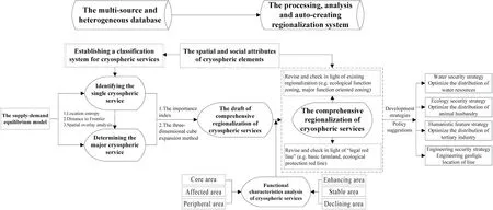
Fig. 3. The technical flowchart of comprehensive regionalization.

Table 1The classification system for cryospheric services.

Fig. 4. Schematic diagram of cryospheric services.
For integration of the above-mentioned procedures, the Distance to Frontier method was referenced and further improved in that the integrated frontier distance was formed by scores and rankings simultaneously. More narrowly, for each service type,the integrated frontier distance of each grid was calculated, which offers the basic foundation for identifying the single CS. For practical significance, this calculated the gap between the importance of a certain CS in a certain area and the importance of the same CS in a larger geographical area. Furthermore, the grids with the same service and spatial proximity were automatically merged and the sub-region boundaries identified using the grid-merging model.
3.4. Identifying the major cryospheric services
In the same geographical unit, there generally exist multiple services at the same time. In other words, the same geographical unit might be suitable for multiple CSs simultaneously. However, for different CSs, their relative importance is variable to a certain degree, thus the further identification of the major CS is required. Seen originally, the major service refers to the function and role of a certain geographical area (Ri) in a larger geographical area (∑R),especially in terms of natural resources and ecological environment systems, as well as living-ecological-production related activities. Location entropy reflects the relative specialization levels of factor utilization from a certain department. Speaking of higher significance, location entropy indicates the status and role of a certain area in a larger area.The location entropy algorithm is developed based on the location entropy model:

where atis the relative importance value of each service in a larger area,m is the total number of categories of CSs,biis the importance value of a service within a certain area, ∑mi=1biis the sum of importance value of all services within this area,Biis the importance value of a service in a larger area.The higher atis, the more important the service is. For instance, basic ecological services with low importance value normally point to cultivated land, desert, construction land, etc., which have little significance for regional and national ecological security.Primary production services with low importance value are mostly urban, woodland, water, desert, and other areas where agriculture and animal husbandry cannot be carried out.
3.5. The comprehensive regionalization of cryospheric services
Based on the three-dimensional cube expansion method and the importance index of CS, the comprehensive regionalization of CSs can be accomplished. The first-grade regions and second-grade regions have a logical relationship similar to primary and secondary contradiction, which focus on the law of territorial differentiation of CSs. In detail, the first-grade regions start with the major CS and the main control role of the glacier, snow cover, and frozen ground. The second-grade regions start with the secondary factors that cause the differences in CSs, and take the spatial distribution differences of the sub-category services of the cryosphere and the degree of cryospheric vulnerability into consideration.It is worth noting that the grid-scale is an auxiliary research scale.
The three-dimensional cube expansion method is mainly used for the first-grade regionalization. The basic principle is to establish a three-dimensional coordinate system, which can select the type, amount, proportion, carrying capacity, and strength as the evaluation dimensions to form a 3×3×3 cube expansion map, as shown in Fig. 5. The system ensures that the major CS is relatively consistent within the region and the difference among regions is maximized.
The importance index of the CS method is mainly used for second-grade regionalization. First-grade regionalization is subdivided according to the importance degree of the CS.Taking the water resources service as an example, based on the first-grade regionalization, the water resources service is further divided into priority development regions (industrial and agricultural), key development regions (commercial mineral water), restricted development zones (ecological protection), etc. The boundaries will be revised in combination with administrative divisions and watershed boundaries, which guarantee that the boundaries of the secondgrade regions will not be overlapped with the first-grade regions:

where I represents the importance index of CS, P1represents the water storage capacity of the glacier, snow cover, and frozen ground, P2represents the proportion of the melt-water supplied by the glacier, snow cover, and frozen ground to the total water in its core and affected region, P3represents the regional regulating ability of the cryosphere,and kirepresents the coefficient weight. It should be ensured that k1+ k2+k3= 1.
3.6. Exploration for dynamic and comprehensive regionalization
As the concept of time is most easily overlooked in existing regionalization studies, a majority of comprehensive regionalization is only carried out on average conditions for a certain period of time. Climate change and human activities have exerted a significant impact on geographical system elements and their interrelationships (Cao et al., 2013). Correspondingly, limitations are becoming more and more remarkable in characterizing the dynamic characteristics of the geographical system based on the average time series data reflecting the long-term state of the system (Wu et al., 2010). Combining static volume and the dynamic volume, multi-scenario and dynamic regionalization as well as regionalization of humannatural element coupling will become the mainstream in the future (Peng et al., 2018).
In order to realize the multi-scenario and dynamic regionalization of CSs,a scenario analysis method can be used to set up the current system and future development scenarios.Correspondingly, high-resolution, multi-scale, and long time series data are indispensable.First,it is of great importance to figure out how cryospheric elements change under different climate change scenarios, such as depth of frozen ground,snow cover, surface runoff, and ground temperature. For climate models, the inter-sectoral impact model intercomparison project (ISI-MIP) can be used to simulate the Global Climate Model under five Representative Concentration Pathways scenarios with spatial downscaling and bias correction. Combined with the population, GDP, technical productivity,and other socio-economic indicators from Shared Socio-economic Pathways scenarios (Shi et al., 2014; Wu et al., 2016; Liu et al., 2018), the responses and changes of CSs can be predicted and discussed. After drawing up the dynamically comprehensive regionalization of CSs in view of corresponding constraints, criteria, and a unified method system,the characteristics and status of different scenarios can be revealed directly, providing basic support for economic adjustment measures, industrial adjustment paths, and ecological protection measures.
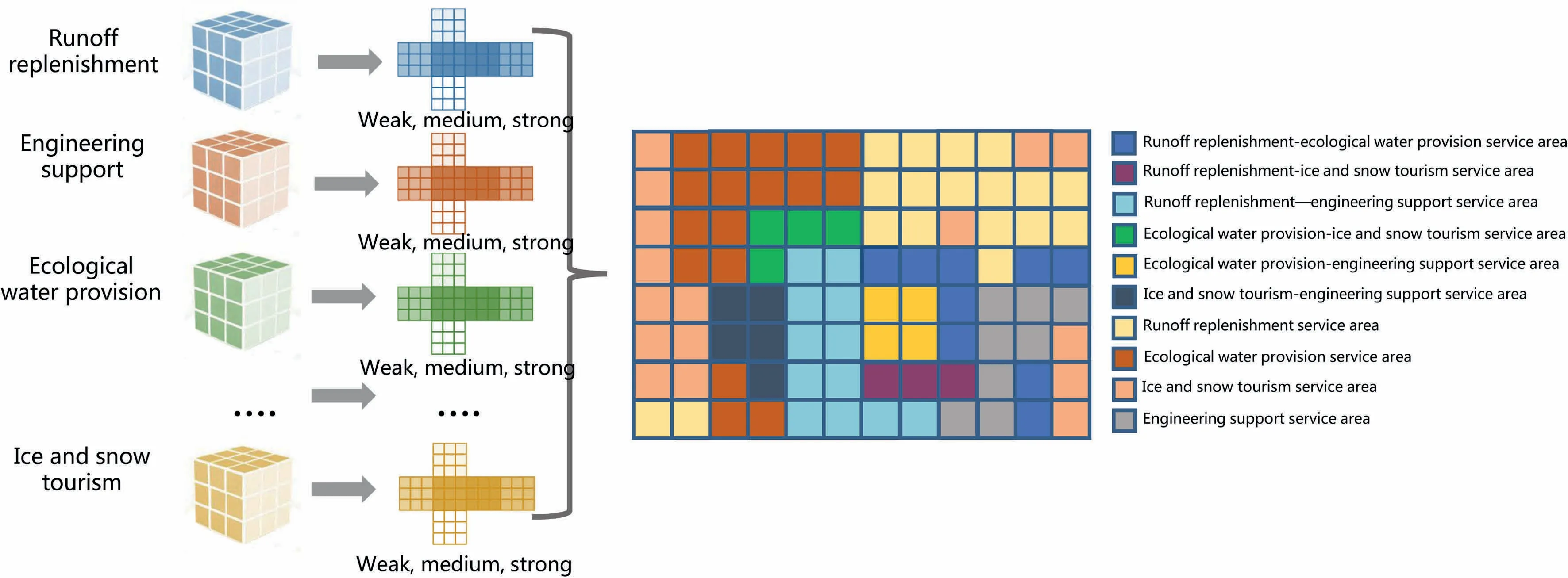
Fig. 5. Conceptual chart of the three-dimensional cube expansion method.
4. Conclusion and discussion
The evolution of socio-economic needs has generated new regionalization schemes and served as intrinsic motivation for methods and technological innovation. As global warming continues, influences resulting from the dynamic changes of CSs, both on the global and regional scales, are increasingly widespread and far-reaching. With emphasis on interdisciplinary approaches and multi-source and heterogeneous database, this study constructed a comprehensive regionalization research system, suitable for cryospheric characteristics, that integrates the natural supply and human demand factors.Based on the rule of territorial differentiation, man-land territorial system theory, set theory, information and coding theory, the research system of comprehensive regionalization of CSs proposed in this study comprises establishing a classification system for CSs, identifying the spatial distribution pattern of CSs, and constructing the comprehensive regionalization of CSs, which finally divides the research area into relatively independent, complete, and organically linked CS units of multiple spatial levels.By setting up a bridge between the cryospheric services with socio-economic needs, it has profound and practical significance and implications for implementing the sustainable utilization strategies of CSs and macroeconomic policymaking such as Belt and Road initiative, as well as promoting the development of human geography and cryospheric science. Looking to the future, we should deepen the research from the following perspectives,in view of the status of current research and the obvious problems that need to be addressed:
(1) Improve the research system and technical process.Focusing on the synergy and trade-off relationship of CSs at different scales,the first priority is to improve the comprehensive regionalization of CSs on the multigrade, multi-scale, multi-scenario levels, and finally to solve the problem of multi-scale integration.
(2) Establish the value assessment system of CSs. With the goal of connecting CSs with the market value system,systematically evaluating the services of different elements and different types is also extremely urgent.
(3) Reveal the evolutionary characteristics of CSs over a long period of time. Through analysis of multi-source and heterogeneous historical data, the evolutionary dynamics of the spatial scale and proportion of CSs can be discovered. On this basis, the evolution law and transformation rule of quantity combination and spatial layout can be condensed.
(4) Excavate the quantitative evolutionary mechanism of CSs. Extracting and exploring the key factors and their interconnections affecting the growth,development,and spatial distribution of CSs in the process of regional development lays solid foundations for establishing a comprehensive analysis framework for the driving mechanisms of CSs.
Conflict of interest
The authors declare no conflict of interest.
Acknowledgments
This research was financially supported by the National Natural Science Foundation of China (41690145).
杂志排行
Advances in Climate Change Research的其它文章
- A new look at roles of the cryosphere in sustainable development
- Valuating service loss of snow cover in Irtysh River Basin
- Impact of climate change on allowable bearing capacity on the Qinghai-Tibetan Plateau
- An ecosystem services zoning framework for the permafrost regions of China
- Modeling the carbon dynamics of alpine grassland in the Qinghai-Tibetan Plateau under scenarios of 1.5 and 2 °C global warming
- Integrated impacts of climate change on glacier tourism