基于多种差异影像算法改进回溯土地覆被变化检测方法的探讨
2019-06-09蒋月邢瑾何江刘巨峰
蒋月 邢瑾 何江 刘巨峰


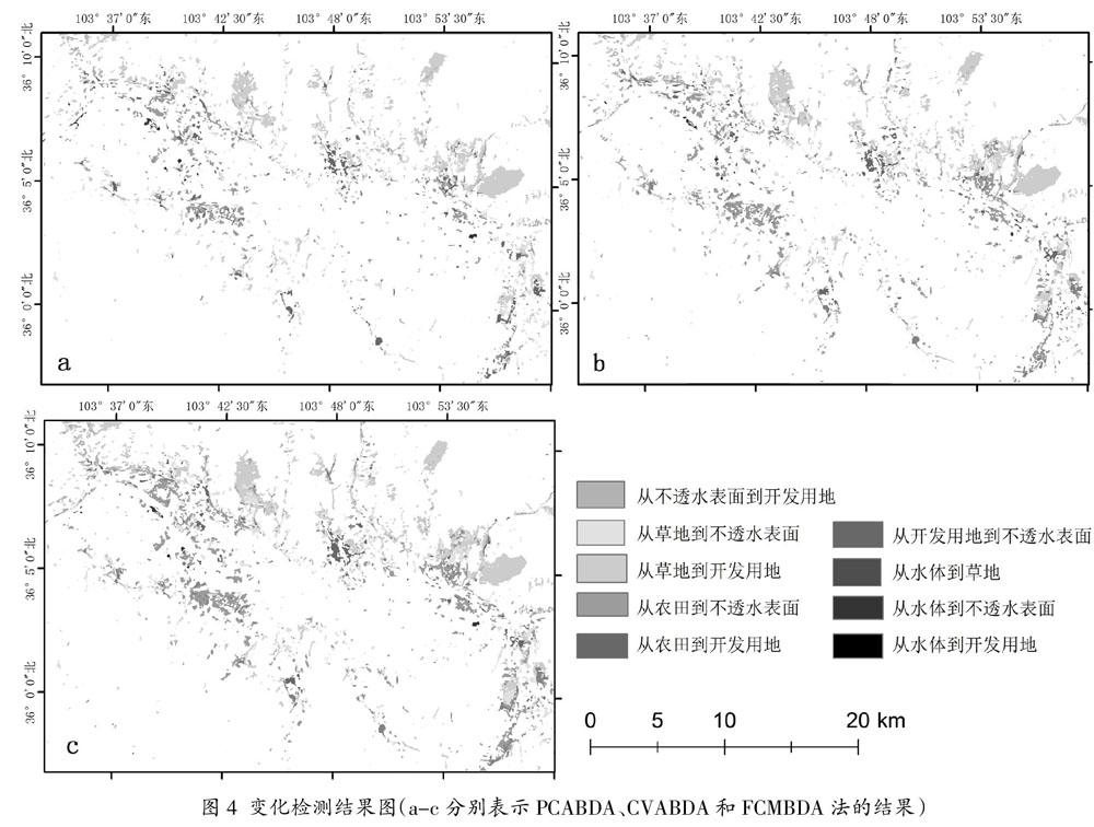
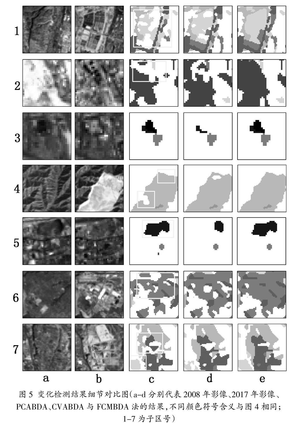
摘 要:近年来,回溯分析方法已经越来越多地应用于自动化变化分析和分类研究中。以兰州市2008和2017年两期Landsat影像为例,分别采用基于PCA、基于CVA和基于FCM的回溯分析方法获得兰州市2008-2017年间的土地覆被分布和变化情况并对其结果进行对比,分析了不同的差异影像算法在回溯分析中的适应性。结果表明基于FCM的回溯分析方法的结果最好,分类总体精度达到88.5%,变化检测结果总体精度达到83.8%;基于CVA的回溯分析方法次之,因存在漏检现象导致分类总体精度为86%,变化检测结果总体精度不足80%;而基于PCA的回溯分析方法精度最低。通过采用FCM算法有效改善土地覆被变化检测结果中的漏检现象,从而获得精度较高的分类及变化检测结果。
关键词:基于对象影像分析;差异影像;回溯分析;变化检测;对比研究
中图分类号:TP75 文献标志码:A 文章编号:2095-2945(2019)07-0001-07
Abstract: In recent years, backtracking analysis methods have been more and more used in automatic change analysis and classification research. Taking the Landsat images of Lanzhou City in 2008 and 2017 as an example, the distribution and change of land cover in Lanzhou City from 2008 to 2017 were obtained by using the backtracking analysis methods based on PCA, CVA and FCM respectively, and the results were compared. The adaptability of different differential image algorithms in backtracking analysis is analyzed. The results show that the backtracking analysis method based on FCM has the best results, the overall accuracy of classification is 88.5%, and the overall accuracy of change detection results is 83.8%, followed by the backtracking analysis method based on CVA. Because of the phenomenon of missed detection, the overall accuracy of classification is 86%, the overall accuracy of change detection results is less than 80%, and the accuracy of backtracking analysis method based on PCA is the lowest. By using FCM algorithm to effectively improve the phenomenon of missed detection in the results of land cover change detection, the classification and change detection results with high accuracy can be obtained.
Keywords: object-based image analysis; differential image; backtracking analysis; change detection; comparative study
1 概述
土地覆被的組成和变化是当今全球变化研究的热点,对于研究环境变化、城市扩张、土地规划等具有重要作用[1]。而Landsat系列数据以其多光谱、高时频等优势使得土地覆被变化研究有了可靠的数据保障。
国内外学者在遥感城市土地覆被变化领域做了大量的研究工作,主要采用直接比较法和分类后比较法进行研究。前者只能得到变化或未变化的二元信息,而后者可以获得具体的类型转换信息[2-6]。然而,分类后比较法受每幅影像分类精度和分类误差累积效应的影响,使得结果精度较低并产生一些不符合逻辑的转换类型[7,8]。一些研究通过提高分类精度以解决此问题,并取得了一些成果[9-11],然而虽然可以避免部分误差,但难以有效改善误差的累积放大效应。
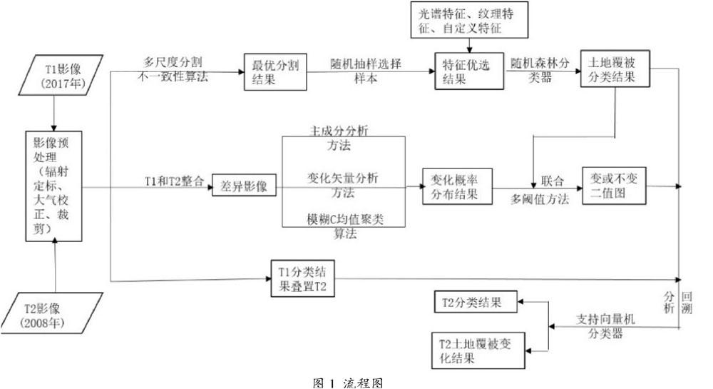
通过直接比较与分类后比较法相结合以提高结果精度已成为一种新方式[12]。相关研究中[7,8,12,13],回溯分析已经越来越多地应用于自动化变化分析和分类研究中。回溯分析以最新影像的土地覆被结果为参考,通过与前期影像的比较分析,得到前期影像分类结果。该方法可以在像元和对象的基础上实现,国外一些研究证明了基于对象的影像分析在回溯分析中的有效性[9]。而国内外涉及采用回溯分析法的研究主要侧重于如何改进算法提高回溯分析的分类与变化检测精度以及自动化水平[7,13-15]。对于如何利用不同的差异影像算法改进回溯法分析,从而获得精度较高的土地覆被分类及变化结果,相关研究较少。针对这一问题,本文以兰州市2008和2017年两期Landsat影像为例,分别采用基于PCA、基于CVA和基于FCM的回溯分析方法获得兰州市2008-2017年间的土地覆被分布和变化情况并对其结果进行对比,更好地分析了不同的差异影像算法在回溯分析中的适应性。
