Land Use Analysis of Yichun-Wanzai Expressway
2019-01-14,,
, ,
College of Urban Construction, Jiangxi Normal University, Nanchang 330022, China
Abstract As the core development axis of the Yichun-Wanzai Economic Corridor, the Yichun-Wanzai Expressway covers all aspects of economic development. It carries the arduous mission of the rapid development of the integration of Yichun and Wanzai. The land use problem is the primary issue to be considered in the overall planning of the planned area along the expressway. This article analyzes the status and suitability of land use with view to guiding the construction of Yichun-Wanzai Expressway.
Key words Status, Suitability, Land use, Analysis
1 Introduction
In order to promote the integrated development of Yichun and Wanzai and strengthen the comprehensive strength of Yichun, the Yichun Municipal Party Committee and Municipal Government have clarified the task of focusing on the construction of Yichun-Wanzai Expressway in the near future. Through the construction of Yichun-Wanzai Expressway, the traffic connection between the central city and Wanzai is enhanced, and the development along the expressway is promoted. The Yichun-Wanzai Expressway is one of the main axes of the Yichun-Wanzai Economic Corridor. It is the focus of the construction of the Yichun-Wanzai Economic Corridor, giving full play to the advantage of the traffic location that connects the north and the south. Taking new carriers and new business as the core, focusing on emerging high-end industries, new economic growth points will be cultivated to make the Yichun-Wanzai Expressway become a high-end industrial cluster, driving the overall development of the Yichun-Wanzai Economic Corridor. The planned area along the Yichun-Wanzai Expressway will be coordinated. The primary consideration is land use issues. Based on the land use planning of Yichun City and the overall plan of Yichun City, the land use conditions along the expressway are defined in this paper to provide important support for the subsequent planning and development.
2 Status analysis of land use
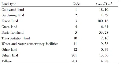
Based on the land use planning of Yuanzhou District and the land use planning of Wanzai County, the status of land use within the planned scope is clarified (Table 1). The total planned land area is 220.26 km2. The core area of the Yichun-Wanzai Economic Corridor covers an area of 3 142.95 km2. The planned area has reached 7%. Most of the land used for the current situation is forest land and cultivated land. The area of forest land and basic farmland is 100.18 and 53.28 km2, respectively. The proportion of forest land and basic farmland reaches 69.7% of the total planned area. Urban land and industrial land are relatively small. The two types of land only account for 6.2% of the total land use, and they are mainly concentrated in the eastern part of Yuanzhou District and southeast of Wanzai County.

Table 1 Status of land use within two kilometers of the Yichun-Wanzai Expressway
3 Planning dynamic analysis
The land use status map is superimposed with the overall plannings of Wanzai County, E’feng Town, Zhaixia Town and Lucun Township to clarify the relationship between the planned construction land in the urban overall plan and the current land use in the land use planning. The analysis shows that the scope of the planned construction land has expanded a lot of land on the basis of the original scope. However, from the perspective of the entire planning scope, the planned land is relatively scattered. Around the main line of Yichun-Wanzai Expressway, only the Lucun Township covers planned construction land. The overall layout cannot be connected in series, and it is difficult to meet the planning layout and land use of the Yichun-Wanzai Economic Corridor.
4 Suitability analysis of construction land
Through elevation analysis, slope analysis and aspect analysis within the study area, comprehensively considering land use planning and urban overall plan, suitability evaluation of land use is conducted to provide basis for the choice of construction land along the expressway. The land used in the planning area is divided into five categories, the land that has been constructed, the land that is suitable for construction, the land that can be constructed, the land that is not suitable for construction and the land that is prohibited from construction (Table 2). Among them, the land that has been constructed is the land where the central city, townships, and villages are located within the planned scope. The land that is suitable for construction has a slope less than 10%, flat terrain and small relative height difference. Its natural environmental conditions such as engineering geology are superior. It can adapt to the construction needs of various facilities. It generally does not need or only requires a little engineering effort for construction. The land that can be constructed refers to the land with slope of 10%-25%, general natural environmental conditions, and certain height difference. It requires certain engineering measures and can be used for construction after a slight improvement in conditions. This category of land has some restrictions on the distribution of facilities or engineering projects. The land that is not suitable for construction refers to the land with slope of 25%-50%, large height difference, poor natural environmental conditions, and relatively complicated terrain (general farmland in the land use planning or the land with terrain lower than the flood line). It requires specific engineering measures, and can be built after improving the conditions. This category of land has greater restrictions on the distribution of facilities or engineering projects. The land that is prohibited from construction has a slope of more than 50%, and a very complicated terrain. It also refers to the basic farmland, ecological forest land, waters,etc. in the land use planning. It is not used as construction land.

Table 2 Suitability evaluation of land use
The proportion of built-up areas is relatively small, less than 7%. The land that is not suitable for construction such as mountains accounts for 8.6%. The overall development intensity of the planned area is low. The area of land suitable for construction has reached 38.1%. Although the area is 8 397 ha, the land is extremely scattered, not conducive to the industrial cluster development and various functional layouts of the Yichun-Wanzai Economic Corridor, blocking the economic development of the core area of the Yichun-Wanzai Economic Corridor, and making it difficult to generate radiation to drive economic development along the expressway. Thus, the Yichun-Wanzai Expressway cannot play the role as the core and tie of the Yichun-Wanzai Economic Corridor. Only through planning the basic farmland, forest land, and construction land in some areas properly and adjusting the use properties of corresponding land, can the scattered construction land be linked property, forming clustered, strip-shaped construction land, and meeting the project construction within the planned scope of the Yichun-Wanzai Expressway.
杂志排行
Asian Agricultural Research的其它文章
- Optimization of Germinated Conditions for Somatic Embryos in Liriodendron Hybrids
- Effects of Different Times of Bagging on Fruit Quality and Disease and Pest Incidence of Fuji Apple
- Effects of Bio-organic Selenium on Agronomic Economic Traits and Selenium Absorption and Distribution in Rice
- Effects of Different Water-soluble Fertilizers on Yield and Quality of Strawberry under Integrated Application of Water and Fertilizer
- MEC Based Study of Brand Building of Hongyue Garden Maker
- Effects of Human Capital Investment on Entrepreneurial Capability of New Generation of Migrant Workers
——An Empirical Study Based on Questionnaire Survey in Chongqing
