山地丘陵区耕作田块修筑工程设计参数及田块特征——以重庆为例
2017-12-18钟守琴刘涓刘卫平魏朝富
钟守琴,刘涓,刘卫平,魏朝富
山地丘陵区耕作田块修筑工程设计参数及田块特征——以重庆为例
钟守琴,刘涓,刘卫平,魏朝富
(西南大学资源环境学院,重庆 400715)
在山地丘陵区,耕作田块修筑工程的参数设计对该区域农业机械化、规模化及产业化发展起着决定性作用。但过去的研究主要集中在工程前后田块特征及土壤特性上,缺乏对其最基本工程设计参数的研究。因此,明确山地丘陵区耕作田块修筑工程参数设计的技术要点对该区域耕地资源的可持续发展有着非常重要的实践指导意义。以重庆山地丘陵区2010—2015年间实施的28个耕作田块修筑工程区为研究对象,通过开展实地调研,对山地丘陵区耕作田块修筑工程设计参数及其对耕作田块特征的影响进行了研究。(1)选址方法:地形坡度在25°以上的区域为禁止建设区,地形坡度在25°以下的区域为有条件建设区,其中,15°以下的区域为重点建设区。在地形坡度<6°且集中连片面积在3.33 hm2(50 mu)以上的区域(类型区A)重点布设条田与缓坡地;在扣除类型区A的基础上,地形坡度<15°且集中连片面积在3.33 hm2(50 mu)以上的过渡区域(类型区B),条田、梯田、梯地及缓坡地均可布设;在扣除类型区A和B的基础上,地形坡度<25°且集中连片面积在3.33 hm2(50 mu)以上的区域(类型区C)主要布设梯田与梯地。(2)工程设计参数:条田、梯田、梯地及缓坡地的田块长度宜分别设置为50—200、50—200、30—200及50—300 m;田块宽度宜分别设置为30—100、10—30、5—20及50—100 m;条田与梯田的田面坡度均为0°,梯地与缓坡地的田面坡度宜分别小于10°与6°;条田及缓坡地的田坎一般均可采用夯砌土坎,但如果其土壤特性不能够满足工程施工要求时,亦可采用条石或块石为主材进行修筑。而梯田与梯地则可分别采用浆砌条石与干砌条石,但如果区域内条石匮乏,其运输成本较高的情况下,以满足工程稳定性为前提,亦可采用浆砌块石或夯砌土坎。(3)对田块特征的影响:耕作田块修筑工程打破了原有田坎,将原本分散、细小及不规整的田块进行合并与再规划,最终组合形成面积较大的、形状规整的、分布相对集中的耕作田块。耕作田块修筑工程实施后,田块平均规模从0.23 hm2提升为0.63 hm2,提升了1.79倍;田块形状指数从18.02降低为10.22,降低了7.80;田块密度从7.09个/hm2降低为3.35个/hm2,降低了3.74个/hm2;田块面积的Moran’s I指数从0.1937提升到0.3501,提升了0.1564。依据地形坡度与最小耕作田块修筑单元,可将山地丘陵区耕作田块修筑工程建设为条田、梯田、梯地及缓坡地4种类型,能够显著地改善山地丘陵区耕地破碎化现状,有效地促进该区域农业机械化、规模化及产业化发展,其工程设计除依据考虑地形、水文及土壤特性外,更应注重就地取材,降低建造成本。
山地丘陵区;耕作田块修筑;工程设计参数;田块特征
0 引言
【研究意义】在山地丘陵区,耕地的破碎化严重限制了该区域农业的规模化生产[1-2],阻碍了中国农业现代化的进程[3-8]。作为影响耕地破碎化的主要因素之一[9],耕作田块修筑工程的参数设计对山地丘陵区农业机械化、规模化及产业化发展起着决定性作用。因此,在山地丘陵区开展本次研究具有非常重要的实践指导意义。【前人研究进展】作为田间作业的基本单元,耕作田块是指由田间末级固定沟、渠、路及田坎等围成的田(地)块[10-11]。而耕作田块修筑工程作为农地整理的核心内容[12],主要包括田块归并、田面平整、田坎修筑等。同时,根据其土地利用类型及地形坡度的差异,可将耕作田块修筑工程分为条田、梯田、梯地及缓坡地4种类型修筑工程[13]。其中,条田是指地形坡度在6°以下的面积较大的水田,其耕作田面水平,成矩形或梯形;梯田是指在坡地上沿等高线分段修建田坎所形成的阶梯式水田;梯地指在坡地上沿等高线分段修建田坎所形成的阶梯式旱地;缓坡地是指田面坡度在6°以下的面积较大的旱地,其耕作田块内较规整,可为矩形或梯形。耕作田块修筑的初衷是改善耕地破碎化的现状,提高耕地质量。然而,部分不合理的耕作田块修筑工程也可能加剧耕地破碎化[14-15]与土地退化[16]。耕作田块修筑过程是一个田块整形与土壤重构的过程,其对耕作田块特征[17]、土壤结构[18-19]及土壤理化特性[20]等都有着重要影响。大多数研究认为,耕作田块修筑能够改善土壤结构[18],增强土壤的团聚性[21],促进有机质的形成与土壤发育[22],提高土壤肥力[23];同时,还能够增大田块规模,降低田块的破碎化程度,促进农业机械化发展[24-26]。另外,耕作田块修筑工程对农田景观格局存在不容忽视的影响[27-29]。Sklenicka[30]研究发现,耕作田块修筑工程能够使得小面积斑块减少,而大面积斑块比重增大。张正峰等[17]研究发现,耕作田块修筑工程能够降低田块形状指数和田块分形维数,提高田块规模,改善田块形状,从而降低田块破碎度。而邓劲松等[31]则研究发现,不合理的耕作田块修筑工程加剧了耕地景观破碎化。因此,合理开展耕作田块修筑工程,能够实现破碎田块的归并,改善该区域耕地耕作条件,提高耕地质量,是促进城乡统筹和现代农业发展的重要举措。【本研究切入点】目前,已有研究主要集中在对工程前后田块特征及土壤特性上,少有关于山地丘陵区耕作田块修筑工程设计参数的研究,因此缺乏相关工程参数设计的技术要点。【拟解决的关键问题】以地形坡度与最小耕作田块修筑单元为限制条件进行耕作田块修筑工程区选址,明确提出了山地丘陵区耕作田块修筑工程工程设计参数的技术要点,揭示了该工程对耕作田块影响的特征。研究结果拟为山地丘陵区耕作田块修筑以及耕地资源的保护与可持续利用工程等提供有效的数据支撑及技术指导。
1 材料与方法
1.1 研究区概况
重庆位于四川盆地东南部,北纬28°10′—32°13′,东经105°11′—110°11′,东邻湖北、湖南,南靠贵州,西接四川,北连陕西,是西南工商业重镇和水陆交通枢纽。重庆幅员面积8.24万平方公里,南北宽450 km,东西长470 km。全市共辖24个区、10个县、4个自治县。地势由南北向长江河谷逐级降低,西北部和中部以丘陵、低山为主,东北部靠大巴山和东南部连武陵山两座大山脉,海拔在100—2 772 m之间,平均海拔约为400 m,属于典型的山地丘陵区(图1)。气候属亚热带季风气候,年均温16—18℃之间,年降雨量在1 000—1 350 mm,降水多集中在5—9月,占全年总降水量的70%左右,年日照总时数1 000—1 200 h。
1.2 研究方法
本研究涉及的耕作田块修筑工程主要包括条田修筑工程、坡改梯修筑工程以及缓坡地修筑工程。其中,坡改梯修筑工程包括改为水平梯田与坡式梯地两种类型。依据地形坡度与最小耕作田块修筑单元,不同类型的耕作田块修筑工程的布设均采用如下方法进行。
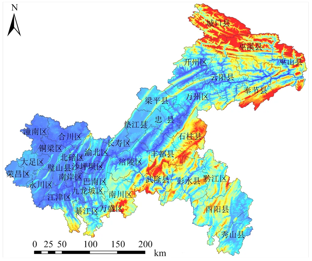
图1 研究区高程图
1.2.1 工程区选址条件 工程区地质构造稳定,耕作田块比重大,具备必要的水利、交通、电力设施,无严重土壤污染或毁损。土地权属明确、界址清晰。地形坡度在25°以上的区域为禁止建设区,地形坡度在25°以下的区域为有条件建设区,其中,15°以下的区域为重点建设区。
1.2.2 建设分区 以3.33 hm2(50 mu)作为田块修筑工程规划最小单元,进行耕作田块修筑类型区划分:(1)类型区A:地形坡度小于6°,且集中连片面积在3.33 hm2(50 mu)以上的区域;(2)类型区B:在扣除类型区A的基础上,地形坡度小于15°,且集中连片面积在3.33 hm2(50 mu)以上的区域;(3)类型区C:在扣除类型区A和B的基础上,地形坡度小于25°,且集中连片面积在3.33 hm2(50 mu)以上的区域。类型区A、B与C即作为耕作田块修筑区进行修筑,不同的修筑区适用的工程类型见表1。
根据上述耕作田块工程区的选址方法,本研究于2016年2月—5月,在重庆山地丘陵区,选取了10个区,其中包括合川、潼南、铜梁、江津、綦江、万盛、长寿、梁平、万州及开州区,对国土部门在2010—2015年间实施的28个耕作田块修筑工程区进行基础数据调研(图2)。选取的28个耕作田块修筑工程区中包含了重庆山地丘陵区3种典型的局地地貌,即缓丘平坝工程区(9个)、丘陵宽谷工程区(14个)与低山丘陵工程区(5个),涉及耕作田块修筑面积2 204.36 hm2,每个工程区基本信息见表2。

表1 耕作田块分区建设条件与类型
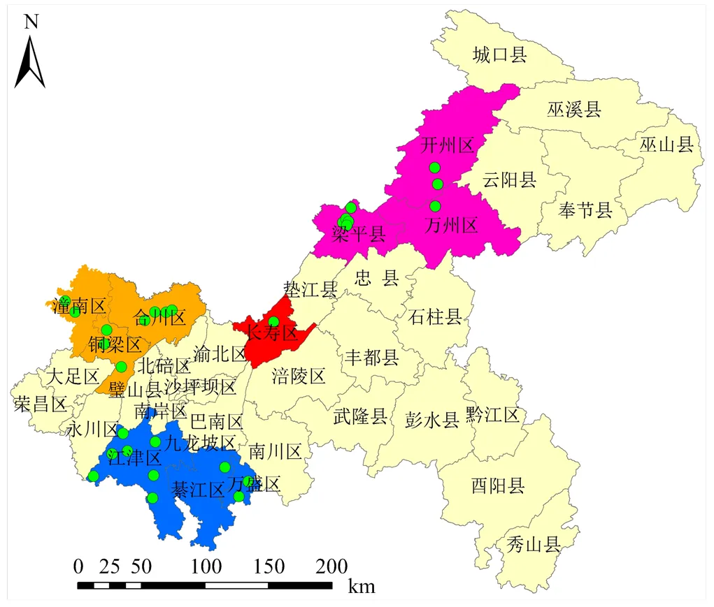
图2 耕作田块修筑工程区位置示意图
1.3 数据采集与处理
通过对28个耕作田块修筑工程区数据分析,明确重庆山地丘陵区不同类型耕作田块修筑工程设计参数的技术要点;同时,在28个耕作田块修筑工程区中,每种地貌类型选择2个工程区(P1、P5、P10、P20、P21及P27),从田块规模、形态及空间特征3个方面[16,32-34],分析耕作田块修筑工程对田块特征的影响。本文主要利用Excel2010软件进行数据处理,利用Auto CAD 2007及ArcGIS 9.3进行图形处理。
2 结果
2.1 耕作田块修筑工程设计参数
2.1.1 条田修筑工程 在山地丘陵区耕作田块修筑中,条田修筑工程主要集中在地形坡度小于6°的区域。本文涉及28个条田修筑工程区,总面积1032.13hm2(表3)。
(1)田块长度 条田修筑的长度范围为30—200m。其中,田块长度在30—100、30—150、50—100、50—150、50—200、80—150及100—150m的工程区分别为1、1、3、7、14、1及1个;田块长度下限主要包括30 m(2个工程区,占7.14%)、50m(24个工程区,占85.71%)、80m(1个工程区,占3.57%)、100m(1个工程区,占3.57%)4个等级;田块长度上限主要包括100m(4个工程区,占14.29%)、150m(10个工程区,占35.71%)、200m(14个工程区,占50%)3个等级。因此,条田修筑工程田块适宜长度设置范围为50—200m。
(2)田块宽度 条田修筑的宽度范围为20—200m。其中,田块宽度在20—60、20—100、30—100、30—150、50—100、50—200及50—200m的工程区分别为4、6、6、6、4、1及1个;田块宽度下限主要包括20m(10个工程区,占35.71%)、30m(12个工程区,占42.86%)、50m(6个工程区,占21.43%)3个等级;田块宽度上限主要包括60m(4个工程区,占14.29%)、100m(16个工程区,占57.14%)、150m(7个工程区,占25%)、200m(1个工程区,占3.57%)4个等级。因此,条田修筑工程田块适宜宽度设置范围为30—100m,当局部地形受到限制时,应适当调低其下限,可设置为20—100m。
(3)田面坡度 条田田面坡度均为0°,且控制田面内部高差在±3 cm以内。
(4)田坎修筑 条田田坎修筑形式主要包括夯砌土坎(22个工程区,占78.57%)、浆砌块石(3个工程区,占10.71%)及浆砌条石(3个工程区,占10.71%)3种。夯砌土坎:田坎宽度(顶宽)集中在0.3—0.8m,坎高集中在0.4—1.5m,坎内坡度角为63°—84°(内坡比1﹕0.5—1﹕0.1),外坡度角45°—79°(外坡比1﹕1—1﹕0.2);坎基宽度范围为0.42—2.45m。浆砌块石田坎:田坎宽度集中在0.3—0.4m,坎高集中在0.9—1.5m,坎内坡度角为79°—87°(内坡比1﹕0.2—1﹕0.05),外坡度角79°(外坡比1﹕0.2);根据内外坡度角的不同,坎基宽度范围为0.35—0.9m。浆砌条石田坎:田坎宽度为0.5m,坎高集中在0.5—1.5m,坎内外坡度角均为79°(坡比1﹕0.2),坎基宽度一般为0.5m。因此,条田修筑田坎主要采用夯砌土坎,如果有其他需求亦可采用浆砌块石或者浆砌条石。条田修筑工程设计如图3所示。

表2 耕作田块分区建设条件与类型
I:缓丘平坝区;II:丘陵宽谷区;III:低山丘陵区 I: Gentle hill and flatland area; II: Hilly gully area; III: Low hill area
2.1.2 坡改梯修筑工程 重庆山地丘陵区耕作田块修筑中坡改梯修筑工程主要集中在地形坡度小于15°、局部区域不大于25°的区域。坡改梯修筑工程可分为水平梯田修筑与坡式梯地修筑两种。
在28个耕作田块修筑工程区中,涉及到水平梯田修筑工程的有13个,总面积182.21 hm2(表4)。
(1)田块长度 水平梯田修筑的长度范围为30—200m。其中,田块长度在30—150、30—200及50—200m的工程区分别为2个、3个及8个;田块长度下限主要包括30m(5个工程区,占38%)与50m(8个工程区,占62%)2个等级;田块长度上限主要包括150m(2个工程区,占15%)与200m(11个工程区,占85%)2个等级。因此,坡式梯地的田块长度适宜设置范围为50—200m,局部区域可以放开下限为30—200m。

表3 条田修筑工程设计参数
M1:夯砌土坎;M2:浆砌块石;M3:浆砌条石。下同
M1: Ramming ridge; M2: Cemented rocks; M3: Cemented squared stones. The same as below

H:台面高差Height difference of adjacent terrace, m;H1:田坎外边坡高度Outside slope height of ridge, m;d1:田坎顶宽Top width of ridge, m;k:坎基宽度Width of ridge foundation, m;B:田面净宽Clear width of terrace surface (excluding the ridge), m;Bm:田面毛宽Width of terrace surface (including the ridge), m;h1:田坎超高Freeboard height of ridge, m;h2:表土回填深度Depth of topsoil backfilling, m;h3:生土回填压实高度Depth of immature soil backfilling and compacting, m;h4:坎基埋深Embedded depth of ridge foundation, m;α:原田面坡度Slope of terrace before construction, (º);β:田坎内边坡坡度Inner slope of ridge, (º);θ:田坎外边坡坡度Outer slope of ridge, (º)。TK:田坎Ridge;L1:原地面线Ground line before construction;L2:开挖线Excavation line;L3:平整后地面线Ground line after construction;W1:表土剥离Stripping topsoil;W2:挖运土方Excavating and transporting earthwork;T1:生土回填并压实Backfilling and compacting immature soil;T2:表土回填Backfilling topsoil
(2)田块宽度 水平梯田田块的宽度范围为5—30m。其中,田块宽度在5—15、5—20及10—30m的工程区分别为2个、2个及9个;田块宽度下限主要包括5m(4个工程区,占31%)与10m(9个工程区,占69%)2个等级;田块宽度上限主要包括15m(2个工程区,占15%)、20m(2个工程区,占15%)与30m(9个工程区,占70%)3个等级。因此,水平梯田的田块宽度适宜设置范围为10—30m。
(3)田面坡度 水平梯田的田面坡度均为0°,且控制田面内部高差在±3 cm以内。
(4)田坎修筑 主要包括夯砌土坎(4个工程区,占31%)、浆砌块石(1个工程区,占8%)、浆砌条石(8个工程区,占61%)3种形式。夯砌土坎:田坎宽度集中在0.4—0.8m,坎高集中在0.5—1.5m,坎内坡度角为63°—73°(内坡比1﹕0.5—1﹕0.3),外坡度角45°—63°(外坡比1﹕1—1﹕0.5);根据内外坡度角的不同,坎基宽度范围为0.80—2.45m。浆砌块石田坎:田坎宽度集中在0.3m,坎高集中在1.5m,坎内外坡度角均为79°(外坡比1﹕0.2),坎基宽为0.9m。浆砌条石田坎:田坎宽度集中在0.25—0.50m,坎高集中在0.5—1.5m,坎内坡度角为63°—84°(坡比1﹕0.5—1﹕0.1),外坡度角53°—79°(外坡比1﹕0.75—1﹕0.2),坎基宽度范围一般为0.25—0.50m。因此,坡式梯地田坎主要采用浆砌条石。同时,应当注重就地取材,在缺乏条石区域,亦可采用浆砌块石或夯砌土坎,从而降低工程成本。水平梯田修筑工程设计如图4所示。
在28个耕作田块修筑工程区中,涉及到坡式梯地修筑工程的有21个,总面积422.23 hm2(表5)。
(1)田块长度 坡式梯地修筑的长度范围为30—200m。其中,田块长度在30—150、30—200、50—150及50—200m的工程区分别为2个、10个、2个及7个;田块长度下限主要包括30m(12个工程区,占57%)与50m(9个工程区,占43%)2个等级;田块长度上限主要包括150m(4个工程区,占19%)与200m(17个工程区,占81%)2个等级。因此,坡式梯地的田块长度适宜设置范围为30—200m。
(2)田块宽度 田块宽度范围为5—50m。其中,田块宽度在5—15、5—20、10—30及20—50m的工程区分别为3个、12个、5个及1个;田块宽度下限主要包括5m(15个工程区,占71%)、10m(5个工程区,占24%)与20m(1个工程区,占5%)3个等级;田块宽度上限主要包括15m(3个工程区,占14%)、20m(12个工程区,占57%)、30m(5个工程区,占24%)与50m(1个工程区,占5%)4个等级。因此,坡式梯地的田块宽度适宜设置范围为5—20m。

表4 水平梯田修筑工程设计参数
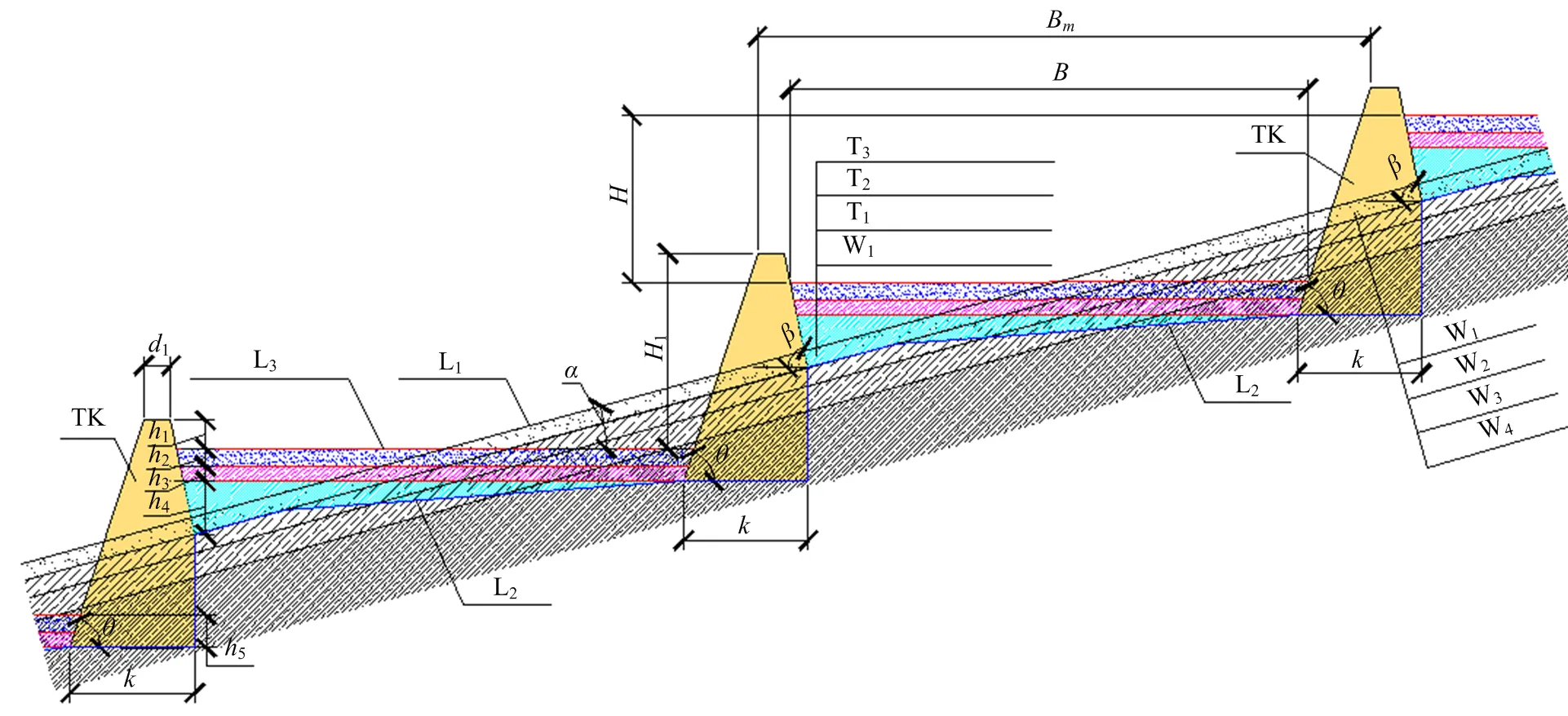
H:台面高差Height difference of adjacent terrace,m;H1:田坎外边坡高度Outside slope height of ridge,m;d1:田坎顶宽Top width of ridge,m;k:坎基宽度Width of ridge foundation,m;B:田面净宽Clear width of terrace surface (excluding the ridge),m;Bm:田面毛宽Width of terrace surface (including the ridge),m;h1:田坎超高Freeboard height of ridge,m;h2:表土回填深度Depth of topsoil backfilling,m;h3:生土回填压实高度Depth of immature soil backfilling and compacting,m;h4:母岩、岩石碎屑回填高度Depth of parent material and rock fragments backfilling,m;h5:坎基埋深Embedded depth of ridge foundation,m;α:原田面坡度Slope of terrace before construction,(º);β:田坎内边坡坡度Inner slope of ridge,(º);θ:田坎外边坡坡度Outer slope of ridge,(º)。TK:田坎Ridge;L1:原地面线Ground line before construction;L2:开挖线Excavation line;L3:平整后地面线Ground line after construction;W1:表土剥离Stripping topsoil;W2:挖运土方Excavating and transporting earthwork;W3:挖运母质Excavating and transporting parent material;W4:爆破石方Blasting rock;T1:母质、岩石碎屑回填Backfilling parent material and rock fragments;T2:生土回填并压实Backfilling and compacting immature soil;T3:表土回填Backfilling topsoil
(3)田面坡度 坡式梯地的田面坡度<10°(19个工程区,占90%),个别工程区不超过15°(2个工程区,占10%)。
(4)田坎修筑 主要包括夯砌土坎(3个工程区,占14%)、浆砌块石(3个工程区,占14%)、干砌条石(15个工程区,占72%)3种形式。夯砌土坎:田坎宽度集中在0.4—0.8m,坎高集中在0.5—1.5m,坎内坡度角为63°—73°(内坡比1﹕0.5—1﹕0.3),外坡度角45°—63°(外坡比1﹕1—1﹕0.5);根据内外坡度角的不同,坎基宽度范围为0.80—2.45m。浆砌块石田坎:田坎宽度集中在0.3—0.4m,坎高集中在0.9—1.5m,坎内坡度角为79°—87°(内坡比1﹕0.2—1﹕0.05),外坡度角79°(外坡比1﹕0.2),根据内外坡度角的不同,坎基宽度范围一般为0.35—0.9m。干砌条石田坎:田坎宽度集中在0.25—0.50m,坎高集中在0.5—1.5m,坎内坡度角为63°—87°(坡比1﹕0.5—1﹕0.05),外坡度角45°—79°(外坡比1﹕1—1﹕0.2),坎基宽度范围一般为0.25—0.50m。因此,坡式梯地田坎主要采用干砌条石。同时,应当注重就地取材,在缺乏条石区域,亦可采用浆砌块石预留放水孔或夯砌土坎,从而降低工程成本。坡式梯地修筑工程设计如图5所示。
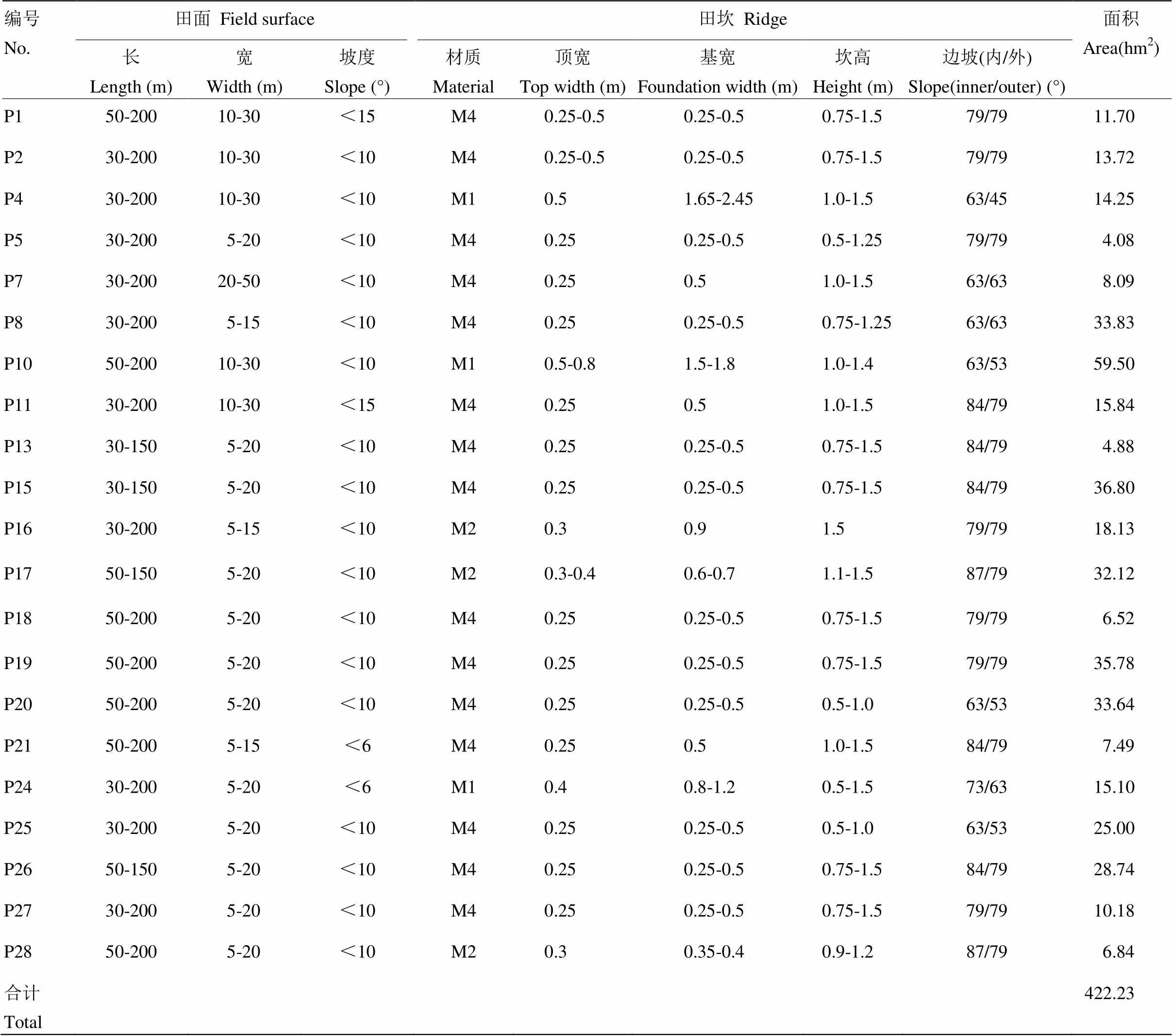
表5 坡式梯地修筑工程设计参数
M4:干砌条石。下同 M4: Dry-laid rag. The same as below

H:台面高差Height difference of adjacent terrace,m;H1:田坎外边坡高度Outside slope height of ridge,m;d1:田坎顶宽Top width of ridge,m;k:坎基宽度Width of ridge foundation,m;B:田面净宽Clear width of terrace surface (excluding the ridge),m;Bm:田面毛宽Width of terrace surface (including the ridge),m;h1:田坎超高Freeboard height of ridge,m;h2:表土回填深度Depth of topsoil backfilling,m;h3:生土回填压实高度Depth of immature soil backfilling and compacting,m;h4:母岩、岩石碎屑回填高度Depth of parent material and rock fragments backfilling,m;h5:坎基埋深Embedded depth of ridge foundation,m;α1:原田面坡度Slope of terrace before construction,(º);α2:平整后田面坡度Slope of terrace after construction,(º);β:田坎内边坡坡度Inner slope of ridge,(º);θ:田坎外边坡坡度Outer slope of ridge,(º)。TK:田坎Ridge;L1:原地面线Ground line before construction;L2:开挖线Excavation line;L3:平整后地面线Ground line after construction;W1:表土剥离Stripping topsoil;W2:挖运土方Excavating and transporting earthwork;W3:挖运母质Excavating and transporting parent material;W4:爆破石方Blasting rock;T1:母质、岩石碎屑回填Backfilling parent material and rock fragments;T2:生土回填并压实Backfilling and compacting immature soil;T3:表土回填Backfilling topsoil
2.1.3 缓坡地修筑工程 缓坡地修筑工程主要集中在地形坡度<6°、局部地形坡度不超过10°的区域。在28个耕作田块修筑工程区中,涉及到缓坡地修筑工程的有12个,总面积603.79 hm2(表6)。
(1)田块长度 缓坡地田块长度范围为30—300 m。其中,田块长度在30—300、50—200、50—300 m的工程区分别为2个、4个及6个;田块长度下限主要包括30 m(2个工程区,占16.67%)、50 m(10个工程区,占83.33%)2个等级;田块长度上限主要包括200 m(4个工程区,占33.33%)、300 m(8个工程区,占66.67%)2个等级。因此,缓坡地修筑工程田块长度范围宜设置为50—300 m;在局部地形受到限制的情况下,应适当降低上限,可设置为50—200 m。
(2)田块宽度 缓坡地修筑的宽度范围为10—100 m。其中,田块宽度在10—50、20—50及50—100 m的工程区分别为1个、4个及7个;田块宽度下限主要包括10 m(1个工程区,占8.33%)、20 m(4个工程区,占33.33%)、50 m(7个工程区,占58.33%)3个等级;田块宽度上限主要包括50m(5个工程区,占41.47%)、100 m(7个工程区,占58.33%)2个等级。因此,缓坡地修筑工程田块宽度范围宜设置为50—100 m;当局部地形坡度较大时,应适当放宽下限,宽度范围可设置为20—100 m。
(3)田面坡度 缓坡地的田面坡度<6°(9个工程区,占75%),个别工程区不超过10°(3个工程区,占25%)。
(4)田坎修筑 主要包括夯砌土坎(8个工程区,占66.67%)及干砌条石(4个工程区,占33.33%)2种形式。夯砌土坎:田坎宽度为0.4m,坎高集中在0.5—1.0 m,坎内坡度角为53°—84°(坡比1﹕0.75—1﹕0.1),外坡度角45°—79°(坡比1﹕1—1﹕0.2),根据内外坡度角的不同,坎基宽度范围一般为0.875—1.15 m。干砌条石田坎:田坎宽度集中在0.25—0.5 m,坎高集中在0.5—1.5 m,坎内外坡度角均为79°(坡比1﹕0.2),坎基宽度范围一般为0.25—0.5 m。缓坡地修筑田坎主要采用夯砌土坎和干砌条石。缓坡地修筑工程设计如图6所示。
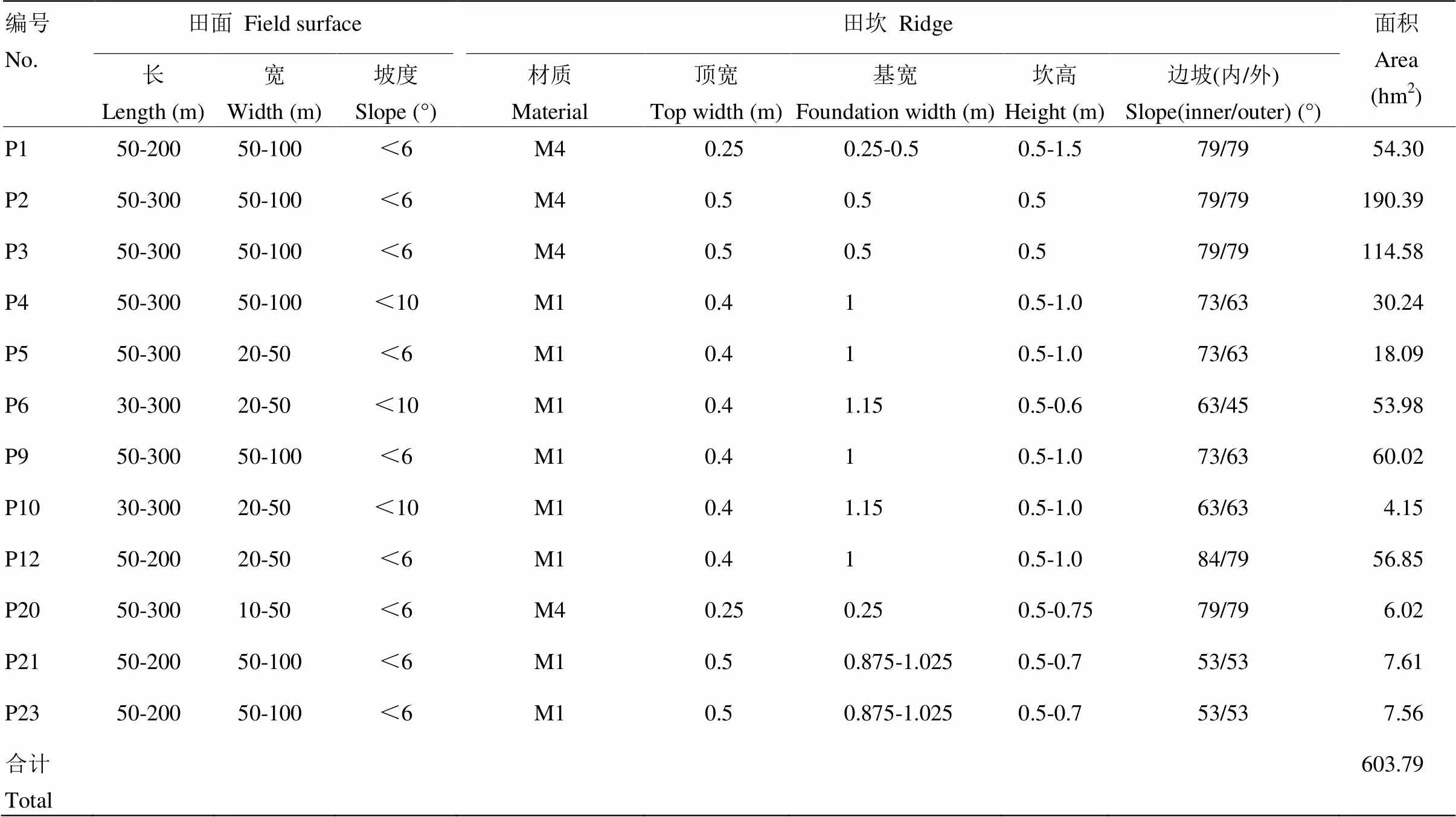
表6 缓坡地修筑工程设计参数

H:台面高差Height difference of adjacent terrace,m;H1:田坎外边坡高度Outside slope height of ridge,m;d1:田坎顶宽Top width of ridge,m;k:坎基宽度Width of ridge foundation,m;B:田面净宽Clear width of terrace surface (excluding the ridge),m;Bm:田面毛宽Width of terrace surface (including the ridge),m;h1:田坎超高Freeboard height of ridge,m;h2:坎基埋深Embedded depth of ridge foundation,m;α:原田面坡度Slope of terrace before construction,(º);β:田坎内边坡坡度Inner slope of ridge,(º);θ:田坎外边坡坡度Outer slope of ridge,(º)。TK:田坎Ridge;L1:原地面线Ground line before construction;L2:开挖线Excavation line
2.2 田块修筑工程对田块特征的影响
2.2.1 田块规模 在耕作田块修筑过程中,田块的归并、重划等工程措施势必会对耕作田块规模产生一定的影响。由图7可知,耕作田块修筑前,田块细碎化程度较修筑后要高,通过耕作田块的修筑,能够显著提高单个耕作田块的面积,有效减少耕作田块的数量。由表7可知,通过耕作田块的修筑,6个工程区的平均田块规模均得到了不同程度的提升,总体上从0.23 hm2提升为0.63 hm2,提升了1.79倍;而田块规模的变异系数(CV)总体上从0.78降低为0.61,其中,P1、P5、P21及P274个工程区的CV值均减小,而P10与P20 2个工程区的CV值反而增大,这说明耕作田块修筑工程在一定程度上会受到地形因素的限制,此时其降低耕作田块面积分布离散度的作用也将受到影响。
2.2.2 田块形状 在现有的土地整理规范与农用地规划标准[35-36]中,以机械作业要求为依据,田块形状最好是矩形(长方形或正方形),其次是梯形,再次是三角形与多边形。由图7可非常直观的看出,耕作田块修筑前后,田块的轮廓由原来不规则弧形变为长方形、梯形居多;再由表8可知,6个耕作田块修筑工程区的田块形状指数及田块分形维数均呈现不同程度的降低,总体上来看,田块形状指数从18.02降低为10.22,降低了7.80,田块分形维数从1.0960降低为1.0546,降低了0.0414,即耕作田块修筑工程能够有效改善耕作田块的规整程度,使其更加有利于机械作业。
2.2.3 田块空间分布 在耕作田块修筑过程中,田块的归并、重划等工程措施势必也会对耕作田块的空间分布产生影响。由表9可知,经过耕作田块修筑,6个耕作田块修筑工程区的田块密度均呈现不同程度的降低,总体上来看,田块密度从7.09个/hm2降低为3.35个/hm2,降低了3.74个/hm2;6个工程区的Simpon指数都较高,接近1,表明重庆丘陵山地耕地破碎化程度严重。经过耕作田块修筑,6个工程区的Simpon指数略有减小。因此,耕作田块修筑能够显著降低田块密度,在一定程度上能够改善田块的破碎化程度。耕作田块修筑前的田块空间分布多以零碎小田块组合为主;再经过耕作田块修筑后,变成了以相对较大田块的组合为主。
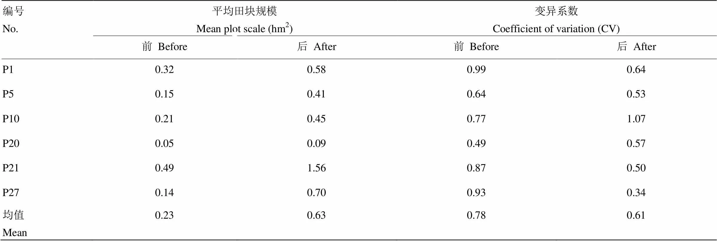
表7 工程前后的田块规模变化情况

P1-1、P1-2分别表示P1工程区耕作田块修筑前后的田块分布情况,其余5个工程区同理

表8 工程前后耕作田块的形状变化
形状指数[32]以正方形为参照,形状指数越大,表示该田块与正方形的差别越大,形状越不规则;分维度指数[33-34],其值介于1与2之间,值越大则田块形状越复杂;当该值等于1时,田块为欧几里德正方形
Based on a square, the larger the shape index[32], the greater the difference between the plot and the square, and the more irregular the shape. The fractal dimension index[33-34]is between 1 and 2, and the larger the value, the more complex the shape of the field. When the value is equal to 1, the field is Euclidean square
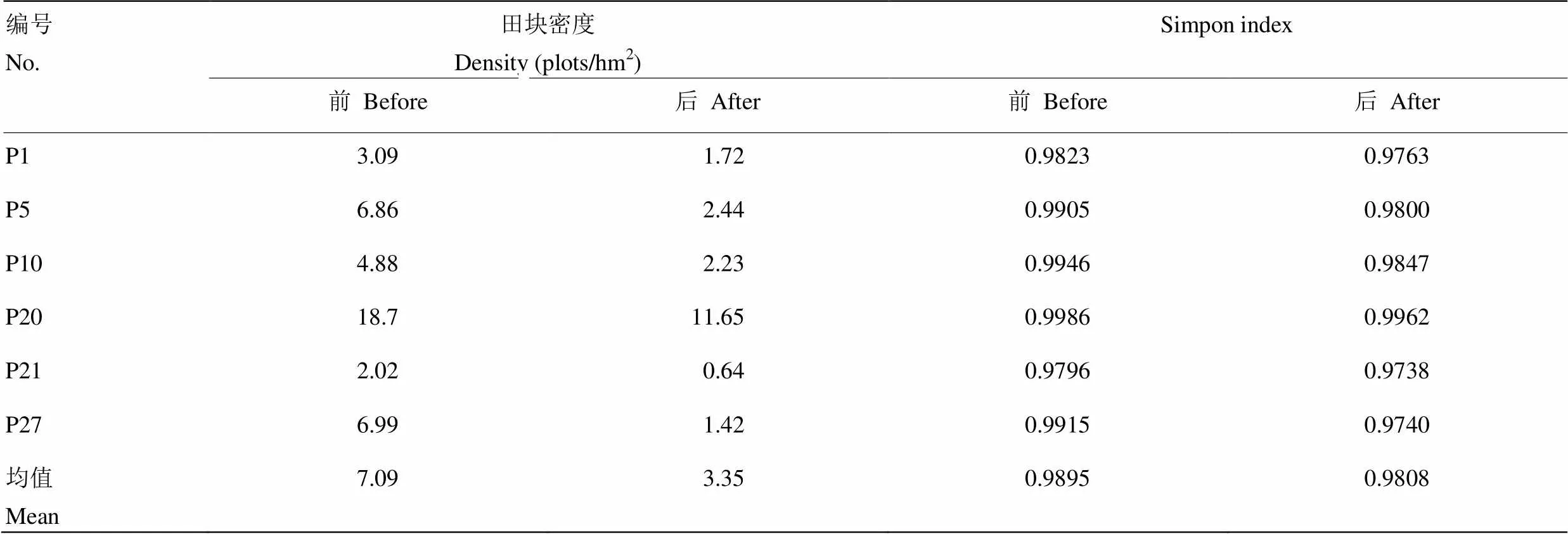
表9 工程前后田块的空间分布变化
为进一步探讨各工程区改造前后田块的空间特征,引入Moran’s I指数对田块面积指数进行空间自相关分析。由表10可知,6个耕作田块修筑工程区的值均小于0.05,即均通过了显著性检验。同时,耕作田块修筑后,Moran’s I数值均得得到了一定程度的提升,总体上从0.1937提升到0.3501,提升了0.1564,这说明耕作田块修筑工程在一定程度上能够提高田块的集聚性。

表10 工程前后田块面积的Moran’sⅠ分析
Moran’s I指数的分析采用的是99次的蒙特卡罗模拟方法,显著性检验水平α=0.05
The Moran’s I index was analyzed using the Monte Carlo simulation method of 99 times. The significance test level was α = 0.05
3 讨论
耕作田块修筑工程能够有效地改善山地丘陵区耕地破碎化现状。目前,已有的研究主要集中在北方平原地区[21,29],缺乏对于南方山地丘陵区耕作田块修筑研究。与平原地区相比,由于受到地形条件的限制,山地丘陵区田块破碎化程度尤为突出[37]。但从中国农业长远发展的角度来看,农业的规模化、集约化及机械化发展趋势不可避免[28]。重庆山地丘陵区破碎化耕地现状极大地阻碍了该区域现代化农业的发展进程。本文研究表明,耕作田块修筑工程能够有效改善其耕地破碎化的现状。通过耕作田块的修筑,田块在规模、形状以及空间分布上均得到了不同程度的改善。在田块的规模上,耕作田块修筑工程能够提高其田块规模,其平均田块规模从0.23 hm2提升为0.63 hm2,提升了1.79倍;在田块形状上,耕作田块修筑工程能够有效改善耕作田块的规整程度,其田块形状指数从18.02降低为10.22,降低了7.80,田块分形维数从1.0960降低为1.0546,降低了0.0414;在田块的空间分布上,耕作田块修筑工程能够有效降低田块密度,其田块密度从7.09降低为3.35,降低了3.74。耕作田块修筑工程打破了原有田坎,将原本分散、细小及不规整的田块进行合并与再规划,最终组合形成面积较大的、形状规整的、分布相对集中的耕作田块。耕作田块修筑工程实施后的田块能够满足研究区农业规模化、集约化及机械化发展的需求,能够有效促进高标准基本农田建设工作的开展。因此,耕作田块修筑工程是改善山地丘陵区耕地破碎化现状的有效措施。
依据地形坡度与最小耕作田块修筑单元,可将山地丘陵区耕作田块修筑工程建设为条田、梯田、梯地及缓坡地4种类型。一般情况下,耕作田块修筑工程能够有效改善耕作田块的破碎化现状,但如果不合理的工程布设反而会使耕地破碎化加剧[14-15,28]。因此,如何合理选择耕作田块修筑区域是关键。在不同地形条件下,耕作田块修筑工程对田块特征的影响不同。本文采用地形坡度与最小耕作田块修筑单元(集中连片度)来对耕作田块修筑区进行选址。地形坡度一般可分为6°、15°及25° 3个等级,其中,地形坡度在25°以上的区域为禁止建设区,地形坡度在25°以下的区域为有条件建设区,在15°以下的区域为重点建设区。在高标准基本农田建设中,规定平原地区最小耕作田块修筑单元为13.33 hm2(200 mu),南方地区为6.67 hm2(100 mu),山地丘陵区可根据具体情况适当减少[33]。因此,本文结合重庆丘陵山区地形特征,最小耕作田块修筑单元为3.33 hm2(50 mu)。将整个耕作田块修筑工程区划分为A、B、C 3个类型区,其中,类型区A地势平缓,适合条田及缓坡地的修筑;类型区B属于过渡区,该区域内部分适合条田及缓坡地的修筑,也存在部分区域地势较类型区A起伏更大,此时布设梯田与梯地修筑工程更为合理;类型区C地势起伏最大,该区域修筑条田与缓坡地的难度较大,因此,只考虑梯田与梯地的修筑。耕作田块修筑工程类型区的划分工作可以借助ArcGIS软件完成。研究表明,通过上述方法进行的耕作田块修筑工程布设,能够有效改善研究区耕地破碎化的现状,工程具备合理性,且该方法具有实际可操作性。在一定程度上,该方法可以有效避免以往按照整治区域的地形地貌笼统地进行工程布设带来的不适宜性,使得工程布设更具合理性。因此,地形坡度与最小耕作田块修筑单元是耕作田块修筑区域选址的重要依据。
耕作田块修筑工程设计需根据建设条件因地制宜进行布设。在本研究中重庆山地丘陵区28个耕作田块修筑工程区,主要的耕作田块修筑方式包括3种,分别为条田修筑、坡改梯修筑(包括水平梯田与坡式梯地的修筑)以及缓坡地修筑。其中,条田修筑包含了传统意义上的条田与格田修筑;而坡改梯修筑主要分为坡式梯田和水平梯田。然而,随着高标准基本农田建设的推广[10,38]与“占优补优、占水田补水田”规定的提出[39],传统的坡改梯工程逐步发展为水平梯田和坡式梯地2种修筑方式,这不仅能体现出耕作田块修筑的类型,而且能体现出土地利用方式,具有较强的实践意义;而缓坡地修筑在本研究中涉及的耕作田块修筑工程区中只有12个,相对其他两种方式要少,这主要由于缓坡地修筑工程在重庆丘陵山区起步较晚。近年来随着农村土地的流转,农业产业化、规模化经营的发展,缓坡地修筑工程才逐渐得到重视,并被国土部门纳入到耕作田块修筑工程中。通过本研究可知,不同类型的耕作田块修筑工程,其工程设计参数也需根据地形条件进行规划设计。在重庆山地丘陵区,条田修筑工程主要集中布设在地形坡度小于6°的区域,其田块长度宜设置为50—200 m,宽度宜设置为30—100 m;梯田修筑工程主要集中布设在地形坡度小于15°的区域,其田块长度宜设置为50—200 m,宽度宜设置为10—30 m;梯地修筑工程也主要集中布设在地形坡度小于15°的区域,其田面坡度宜设计在10°以下,田块长度宜设置为30—200 m,宽度宜设置为5—20 m;缓坡地修筑工程主要集中在地形坡度小于6°的区域,从而保证其田面坡度在6°以下,田块长度宜设置为50—300 m,宽度宜设置为50—100 m。值得注意的是,耕作田块修筑工程设计除考虑地形、水文及土壤特性外,更应注重就地取材,降低建造成本。条田与缓坡地的田坎一般均采用夯砌土坎,但如果其土壤特性不能够满足工程施工要求时,亦可采用条石或块石为主材进行修筑。此时,条田田坎宜采用浆砌条石或块石,而缓坡地田坎则宜采用干砌条石或浆砌块石。梯田与梯地的田坎一般分别采用浆砌与干砌条石,但如果区域内条石匮乏,运输成本较高的情况下,以满足工程稳定性为前提,亦可采用浆砌块石或夯砌土坎。因此,耕作田块修筑工程设计需根据建设条件因地制宜进行布设。对其他类似山地丘陵区的耕作田块修筑工程亦可参考上述工程设计参数,同时也应遵守因地制宜的原则而进行工程布设。
4 结论
在山地丘陵区,依据地形坡度与最小耕作田块修筑单元,可将耕作田块修筑工程规划为条田、梯田、梯地及缓坡地4种类型,其田块长度宜分别设置为50—200、50—200、30—200及50—300 m;田块宽度宜分别设置为30—100、10—30、5—20及50—100 m;条田与梯田的田面坡度均为0°,梯地与缓坡地的田面坡度宜分别小于10°与6°;条田及缓坡地的田坎一般均可采用夯砌土坎,而梯田与梯地则可分别采用浆砌条石与干砌条石。同时,其工程设计除依据考虑地形、水文及土壤特性外,更应注重就地取材,降低建造成本。耕作田块修筑工程能够显著地改善山地丘陵区耕地的破碎化现状,有效地促进该区域农业机械化、规模化及产业化发展。本研究结果可为山地丘陵区的高标准基本农田建设工作提供技术参考。
[1] 叶艳妹. 可持续农地整理的理论与方法研究[D]. 杭州: 浙江大学, 2002.
Ye Y M. Theories and methods of sustainable agricultural land consolidation[D]. Hangzhou: Zhejiang University, 2002. (in Chinese)
[2] Niroula G S, Thapa G B. Impacts and causes of land fragmentation, and lessons learned from land consolidation in South Asia., 2005, 22(4): 358-372.
[3] 谭淑豪, Heerink N, 曲福田. 土地细碎化对中国东南部水稻小农户技术效率的影响. 中国农业科学, 2006, 39(12): 2467-2473.
Tan S H, Heerink N, Qu F T. Impact of land fragmentation on small rice farmers’ technical efficiency in Southeast China., 2006, 39(12): 2467-2473. (in Chinese)
[4] 周应堂, 王思明. 中国土地零碎化问题研究. 中国土地科学, 2008, 22(11): 63-67, 71.
Zhou Y T, Wang S M. Study on the fragmentariness of land in China., 2008, 22(11): 63-67, 71. (in Chinese)
[5] Tin N, Cheng E J, Christopher F. Land fragmentation and farm productivity in China in the 1990s., 1996, 7(2): 169-180.
[6] 刘涛, 曲福田, 金晶, 石晓平. 土地细碎化、土地流转对农户土地利用效率的影响. 资源科学, 2008, 30(10): 1511-1516.
Liu T, Qu F T, Jin J, Shi X P. Impact of land fragmentation and land transfer on farmer's land use efficiency., 2008, 30(10): 1511-1516. (in Chinese)
[7] Wan G H, Cheng E J. Effects of land fragmentation and returns to scale in the Chinese farming sector., 2001, 33(2): 183-194.
[8] Jürgenson E. Land reform, land fragmentation and perspectives for future land consolidation in Estonia., 2016, 57: 34-43.
[9] Tan S H, Heerink N, Qu F T. Land fragmentation and its driving forces in China., 2006, 23(3): 272-285.
[10] 中华人民共和国国家质量监督检验检疫局, 中国国家标准化管理委员会.高标准农田建设通则: GB/T 30600-2014[S].北京: 中国标准出版社, 2014.
General Administration of Quality Supervision, Inspection and Quarantine of the People's Republic of China, Standardization Administration of China. 2014, Well-facilitated farmland construction- General rules, GB/T 30600-2014. (in Chinese)
[11] 鲍海君, 吴次芳, 叶艳妹, 童菊儿, 汪峰. 土地整理中田块设计和“3S”技术应用研究. 农业工程学报, 2002, 18(1): 169-172, 2.
Bao H J, Wu C F, Ye Y M, Tong J E, Wang F. Dimension design of farmland and application of GPS-GIS-RS technology to land consolidation., 2002, 18(1): 169-172, 2. (in Chinese)
[12] 陈兰. 重庆市土地整理规划设计及效益对比分析[D]. 重庆: 西南大学, 2008.
Chen L. Comparative study on land consolidation planning and benefit analysis of Chongqing[D]. Chongqing: Southwest University, 2008. (in Chinese)
[13] 重庆质量技术监督局. 山地丘陵区耕作田块修筑设计技术规范: DB50/T 732-2016[S], 2016.
Chongqing Bureau of Quality and Technical Supervision. 2016, Technical Criterion for the Design of Tillage Fields Construction in Hilly Areas. DB50/T 732-2016[2016-12-30]. (in Chinese)
[14] Wu Z P, Liu M Q, Davis J. Land consolidation and productivity in Chinese household crop production, China., 2005, 16(1): 28-49.
[15] 王军, 严慎纯, 白中科, 余莉, 郭义强. 土地整理的景观格局与生态效应研究综述. 中国土地科学, 2012, 26(9): 87-94.
Wang J, Yan S C, Bai Z K, Yu L, Guo Y Q. Review on landscape patterns of land consolidation and the ecological effects., 2012, 26(9): 87-94. (in Chinese)
[16] 刘涓. 重庆丘陵山地耕作田块修筑的土壤工程效应研究[D]. 重庆:西南大学, 2015.
Liu J. Soil engineering effects of farming plots reconstruction in hilly-mountainous region of Chongqing[D]. Chongqing: Southwest University, 2015. (in Chinese)
[17] 张正峰, 杨红, 谷晓坤. 土地整治对平原区及丘陵区田块利用的影响. 农业工程学报, 2013, 29(3): 1-8.
Zhang Z F, Yang H, Gu X K. Effects of land consolidation in plains and hills on plots use., 2013, 29(3): 1-8. (in Chinese)
[18] 张凤荣, 徐艳. 农村土地整治的理论与实践. 北京: 中国农业大学出版社, 2012.
Zhang F R, Xu Y.. Beijing: China Agricultural University Press, 2012. (in Chinese)
[19] Mihara M. Effects of agricultural land consolidation on erosion processes in semi-mountainous paddy fields of Japan., 1996, 64(3): 237-247.
[20] 王瑷玲, 赵庚星, 王庆芳, 刘文鹏. 丘陵区土地整理对土壤理化性状的影响. 农业工程学报, 2011, 27(9): 311-315.
Wang A L, Zhao G X, Wang Q F, Liu W P. Effects of land consolidation on soil physical and chemical characteristics of hilly region., 2011, 27(9): 311-315. (in Chinese)
[21] 喻光明, 魏雅丽, 鲁迪, 陶文星, 张敏, 王立国. 区域土地整理对生态系统的影响及补偿. 安全与环境学报, 2006, 6(4): 46-49.
Yu G M, Wei Y L, Lu D, Tao W X, Zhang M, Wang L G. Impact of regional land consolidation on the ecosystem and its compensation., 2006, 6(4): 46-49. (in Chinese)
[22] 张源润, 蔡进军, 董立国, 王月玲, 季波, 火勇. 半干旱退化山区坡改梯地土壤养分变异特征研究——以宁夏彭阳县为例. 干旱区资源与环境, 2007, 21(3): 121-124.
Zhang Y R, Cai J J, Dong L G, Wang Y L, Ji B, Huo Y. Research on variation characteristics of soil nutrient after slope land changed into the terrace in semi-arid degenerated mountainous areas—Taking Ningxia Pengyang county as an example., 2007, 21(3): 121-124. (in Chinese)
[23] Liu S L, Dong Y H, Li D, Liu Q, Wang J, Zhang X L. Effects of different terrace protection measures in a sloping land consolidation project targeting soil erosion at the slope scale., 2013, 53(4): 46-53.
[24] Pasakarnis G, Maliene V. Towards sustainable rural development in central and eastern Europe: Applying land consolidation., 2010, 27(2): 545-549.
[25] Luo W, Timothy D J. An assessment of farmers’ satisfaction with land consolidation performance in China., 2017, 61: 501-510.
[26] Fang Y G, Shi K J, Niu C C. A comparison of the means and ends of rural construction land consolidation: Case studies of villagers’ attitudes and behaviours in Changchun City, Jilin province, China., 2016, 47: 459-473.
[27] 杨庆媛, 涂建军, 廖和平, 周宝同, 田永中. 国外土地整理: 性质、研究领域及借鉴. 绿色中国, 2004(12): 49-52.
Yang Q Y, Tu J J, Liao H P, Zhou B T, Tian Y Z. Survey to the land—coordination abroad., 2004(12): 49-52. (in Chinese)
[28] Junker B, Buchecker M. Aesthetic preferences versus ecological objectives in river restorations., 2008, 85(3): 141-154.
[29] Moravcová J, Koupilová M, Pavlíček T, Zemek F, Kvítek T, Pečenka J. Analysis of land consolidation projects and their impact on land use change, landscape structure, and agricultural land resource protection: Case studies of Pilsen-South and Pilsen-North (Czech Republic)., 2016,13(1): 1-13.
[30] Sklenicka P. Applying evaluation criteria for the land consolidation effect to three contrasting study areas in the Czech Republic., 2006, 23(4): 502-510.
[31] 邓劲松, 王珂, 李君, 徐俊锋, 沈掌泉, 高玉蓉. 乡镇耕地整理对耕地景观破碎度的影响研究. 应用生态学报, 2006, 17(1): 41-44.
Deng J S, Wang K, Li J, Xu J F, Shen Z Q, Gao Y R. Impacts of farmland consolidation on farmland landscape., 2006, 17(1): 41-44. (in Chinese)
[32] 徐康, 金晓斌, 吴定国, 周寅康. 基于农用地分等修正的土地整治项目耕地质量评价. 农业工程学报, 2015, 31(7): 247-255.
Xu K, Jin X B, Wu D G, Zhou Y K. Cultivated land quality evaluation of land consolidation project based on agricultural land gradation., 2015, 31(7): 247-255. (in Chinese)
[33] 吴良林, 周永章, 陈子燊, 宋书巧, 周慧杰, 陈秋华. 基于GIS与景观生态原理的土地资源规模化潜力评价. 资源科学, 2007, 29(6): 146-153.
Wu L L, Zhou Y Z, Chen Z S, Song S Q, Zhou H J, Chen Q H. Evaluation methods and its application on potentials of land resources based on GIS technology and theories of landscape ecology., 2007, 29(6): 146-153. (in Chinese)
[34] 吴良林, 罗建平, 李漫. 基于景观格局原理的土地规模化整理潜力评价方法. 农业工程学报, 2010, 26(2): 300-306.
Wu L L, Luo J P, Li M. Evaluation method of land-scaled consolidation potential based on landscape pattern principle., 2010, 26(2): 300-306. (in Chinese)
[35] 郝瑨珉. 土地利用规划. 北京: 中国农业大学出版社, 2007.
Hao J M.. Beijing: China Agricultural University Press, 2007. (in Chinese)
[36] 李卫祥. 农村土地整理. 北京: 中国社会出版社, 2008.
Li W X.. Beijing: China Society Press, 2008. (in Chinese)
[37] 孙雁, 赵小敏. 分宜县土地细碎化的中观尺度研究. 中国土地科学, 2010, 24(4): 25-31.
Sun Y, Zhao X M. Research on land fragmentation of Fenyi county on meso-level., 2010, 24(4): 25-31. (in Chinese)
[38] 中华人民共和国国土资源部. 高标准基本农田建设标准: TD/T 1033-2012[S]. 北京: 中国标准出版社, 2012.
Ministry of Land and Resources, P.R.China. Standard for well- facilitated capital farmland construction, TD/T 1033-2012. (in Chinese)
[39] 中华人民共和国国土资源部. 《关于强化管控落实最严格耕地保护制度的通知》(国土资发(2014) 18 号). (2014-02-13) [2017-05-18]. http://www.mlr. gov.cn/zwgk/zytz/201402/t20140220_1304242.htm.
Ministry of Land and Resources, P.R.China. Notice on Strengthening the Control and Control of the Most Strict Farmland Protection System. (Land and Resources (2014) No. 18). (2014-02-13) [2017-05- 18]. http://www.mlr. gov.cn/zwgk/zytz/201402/t20140220_1304242. htm. (in Chinese)
(责任编辑 杨鑫浩)
Engineering Design Parameters of Farming Plots Construction and Plot Characteristics in Hilly Area: A Case Study of Chongqing
ZHONG ShouQin, LIU Juan, LIU WeiPing, WEI ChaoFu
(College of Resources and Environment, Southwest University, Chongqing 400715)
In hilly area, the parameters designing of farming plots construction engineering plays a decisive role in the mechanization, large scale production and industrialization of agriculture. To date, with regard to most studies on the plot characteristics and soil properties, the basic engineering design parameters are often ignored. Thus, it is very necessary to find out technical points of the engineering design parameters of farming plots construction, which can promote sustainable development of cultivated land resources in hilly area.In this paper, we took 28 farming plots constructed between 2010 and 2015 in hilly areas of Chongqing as the research object, and the engineering design parameters and its effects on the plot characteristics were studied based on the investigation.(1) Location selection method: The region where the terrain slope is more than 25° should be regarded as the forbidden construction zone. The region where the terrain slope is less than 25° should be regarded as the conditional construction zone, and the region of 15° is the key construction zone. Strip lands and gentle-slope lands were laid in the areas (called Area A), where the terrain slope was less than 6° and the concentrated area of cultivated land more than 3.33 hm2(50 mu). On the basis of the deduction Area A, the areas (called Area B) with terrain slope less than 15° and concentrated area of cultivated land more than 3.33 hm2(50 mu) were mainly suitable to lay strip lands, gentle-slope lands, level terraces and sloping terraces. On the basis of the deduction Area A and Area B, the areas (called Area C) with terrain slope less than 25° and concentrated area of cultivated land more than 3.33 hm2(50 mu) were mainly suitable to lay level terraces and sloping terraces. (2) Engineering design parameters: The length of strip lands, level terraces, sloping terraces and gentle-slope lands should be set to 50-200, 50-200, 30-200 and 50-300 m, respectively. The width should be set to 30-100, 10-30, 5-20 and 50-100 m, respectively. The slope of strip lands and level terraces should be set to 0°. But for sloping terraces and gentle-slope lands, the slope should be set to less than 10° and 6°, respectively. Ramming ridge was widely used in strip lands and gentle-slope lands construction. But if the soil properties can not meet the requirements of construction, rocks and squared stones can also be used for construction. Cemented squared stones and dry-laid rag were used in level terraces and sloping terraces, respectively. But if the squared stones can not be found around the farming plots, and the transport costs would be too much high, cemented rocks and ramming ridge can also be used for construction. (3) Effects on the plot characteristics: The farming plots construction engineering broke the original ridges of fields, and the scattered, small and irregular plots have been merged and re-planned. Finally, the larger, well-structured, relatively concentrated tillage plots can be formed. After the farming plots construction, the mean plot scale increased from 0.23 hm2to 0.63 hm2, increased about 1.79 times. The shape index of the plot decreased from 18.02 to 10.22, decreased about 7.80. The density of the plot decreased from 7.09 plots/hm2to 3.35 plots/hm2, decreased about 3.74 plots/hm2. The Moran’s I index of plots’ area increased from 0.1937 to 0.3501, increased about 0.1564.According to the terrain slope and the smallest construction unit of farming plots, four types of engineering (strip lands, level terraces, sloping terraces and gentle-slope lands) can be considered to be built in the hilly areas. They can significantly improve the fragmentation of cultivated land, and effectively promote the mechanization, large scale production and industrialization of agriculture. In addition, the engineering design should be based on the consideration of topography, soil properties, especially local materials for reducing construction costs in the hilly areas.
hilly area; farming plots construction; engineering design parameters; plot characteristics
2017-03-26;
2017-08-15
国家重点研发计划(2017YFD0800505)
联系方式:钟守琴,E-mail:zhong.qing.1988@163.com。通信作者魏朝富,E-mail:weicf@swu.edu.cn
