径流泥沙实时自动监测仪的研制
2017-09-15展小云郭明航赵向辉
展小云,郭明航,赵 军※,赵向辉
·农业水土工程·
径流泥沙实时自动监测仪的研制
展小云1,2,郭明航1,2,赵 军1,2※,赵向辉3
(1. 西北农林科技大学黄土高原土壤侵蚀与旱地农业国家重点实验室,杨凌 712100;2. 中国科学院水利部水土保持研究所,杨凌 712100;3. 西安三智科技有限公司,西安 710075)
针对径流泥沙过程监测仪缺乏和监测误差大的状况,研制了一种具有野外复杂条件下普遍适用的径流泥沙高精度实时自动监测仪,并建立了数据/站点管理云平台。该仪器从径流泥沙过程中提取驱动仪器运转的物理量并将其转换为测控信号,实现径流泥沙过程的实时自动监测;通过对仪器总体结构及各功能部件的优化设计,消减泥沙粘附和沉积,提高监测精度。通过标准泥沙样品验证了该仪器的适用性,结果表明该仪器监测的含沙量相对误差均值为3.67%,决定系数为0.997。土槽试验获取了径流过程中变幅较宽的径流量和含沙量的动态过程曲线。可见,该仪器不仅可以准确地监测径流泥沙过程,而且创新了水土流失监测技术和方法,推动了水土流失监测的自动化和信息化。
土壤;侵蚀;径流;含沙量;自动化监测
展小云,郭明航,赵 军,赵向辉. 径流泥沙实时自动监测仪的研制[J]. 农业工程学报,2017,33(15):112-118. doi:10.11975/j.issn.1002-6819.2017.15.014 http://www.tcsae.org
Zhan Xiaoyun, Guo Minghang, Zhao Jun, Zhao Xianghui. Development of real-time and automatic measuring equipment for runoff and sediment[J]. Transactions of the Chinese Society of Agricultural Engineering (Transactions of the CSAE), 2017, 33(15): 112-118. (in Chinese with English abstract) doi:10.11975/j.issn.1002-6819.2017.15.014 http://www.tcsae.org
0 引 言
中国是世界上水土流失最严重的国家之一。2004年全国土壤侵蚀量高达16.22亿 t,相当于12.5万km2面积上流失掉1 cm厚的表层土壤,而形成1 cm厚的土壤却需要100年。截止2011年,全国 (未含香港、澳门特别行政区和台湾省)土壤侵蚀面积为294.91万km2,占国土面积的30.7%[1]。水土流失不但导致土壤退化,土地生产力降低,而且对生态环境、人类生存和社会经济发展带来严重影响[2-4]。为实现生态文明建设和社会经济的可持续发展,中国已将水土保持确定为一项长期的基本国策。
水土流失监测是水土保持学科发展、防治水土流失和实施生态文明战略的基础。近年来,中国已建成738个水土保持监测点,在此基础上水利部又制定了全国水土保持信息化规划(2013-2020年),将“国家级水土保持监测点升级”列为重点建设项目,拟开展监测点数据采集智能化升级,配置自动化泥沙监测采集设施设备。除此之外,国家野外站观测研究网络、中国生态研究网络、国家水文监测网络、国家地质环境监测站等部门都建有流域控制站、水土流失监测站和水文监测站,其中径流量和含沙量均为重要的监测指标。面对量大面宽的径流泥沙监测的迫切需要,现有的径流泥沙监测技术和仪器设备却相形见绌。随着现代科学技术的发展,人们一直试图利用各种原理和方法以实现对含沙量较为准确地测量。目前,含沙量的测量方法主要包括称重法、γ射线法、振动法、超声波法、电容法、光电法、激光法和遥感法等[5-8]。由于称重法相对容易实现,至今仍被广泛应用[9-13],但是该方法测量周期长,过程繁琐,不能实时测量,测量结果只是随机时间段内的平均值,无法反映含沙量的即时变化,并且测量误差较大[14-15]。近年来,雷廷武等[16-17]研制基于γ-射线测量含沙量的系统,尽管该方法有很大的测量优势,但是由于137Cs放射源安全防护很困难,对人体危害很大,因而无法广泛使用[18-19]。振动法测量含沙量时由于零点漂移严重,测量结果稳定性较差[20]。Bonta[21]提出的超声波法测量含沙量的范围较窄,仅适合于低含沙溶液的测量[22]。电容法中由于电容受温度影响较大,电容两端输出电压随温度、土壤含盐量升高而呈非线形增加趋势,电容测量精度要达到1 PF,目前电容测量技术远不能达到,加之径流流速的影响,使得电容法的适用条件受到很大限制[23-24]。曾为军等[8]提出了一种基于计时法和光电法的径流量与含沙量的测量方法,设计了坡面径流量及含沙量同步在线检测的自动监测系统,但是该方法仍然是受到泥沙比重、不同颗粒组成及泥沙沉积等状况的严重影响而未能广泛应用[25-27]。此外,由于在坡面侵蚀过程中,径流中泥沙粒径的组成随时间不断变化,使得激光法具有了一定的测量误差[28]。遥感法根据卫星遥感摄影获得的河口、河流、水库、湖泊等地区悬浮泥沙的光谱特性影像,反演计算大面积水域水体的平均含沙量,该方法多用于大范围低含沙量测量,不能在坡面、沟道进行定点高精度的测量[29-30]。
可见,上述方法存在各种问题:或者由于受样品采集或元器件性能的限制,不能克服或完全适应泥沙颗粒大小组成的不确定性以及泥沙的粘附性、沉积性的影响,造成监测误差大;或者由于监测现场复杂性,使得仪器不能兼顾变幅较宽的径流量和含沙量的监测;或者由于仪器设备功能设计的缺陷,不能实时监测径流泥沙全过程。有鉴于此,径流泥沙监测亦然继续采用几乎没有仪器概念可言的传统的称重法进行径流泥沙的监测,而这种方法与现代科技发展水平极不匹配,也与当代水土保持学科的发展和水土流失防治需求极不适应。水土保持学术界堪忧,径流泥沙监测的新技术、新设备以及技能型人才缺乏,使得水土保持学科的发展存在严重的科学和技术危机[31]。
因此,本研究将经典的测量原理与现代科学技术结合,研制具有全自动、全过程、高精度、实时监测的径流泥沙监测仪器设备,以实现多场景(径流小区和流域控制站)径流泥沙实时自动监测。通过研制径流泥沙自动监测仪,不但能够获取径流泥沙的过程资料,提高径流泥沙的监测精度,而且可以提升径流泥沙监测的自动化和信息化水平,推动水土保持向定量化、精准化发展,提升国产水土保持监测仪器设备的研发能力。
1 测量原理及参数计算
该监测仪主要是基于定体积的体积-质量转换原理测量含沙量。相对于光电法、透射法等传统的监测方法,该方法可以完全消除泥沙颗粒大小对测量结果的影响。对于特定的径流泥沙样品,当所采集的样品体积一定时,其水、沙所占的体积比和质量比是一定的,即一定体积的径流泥沙样品其总质量等于该样品中泥沙的质量与水的质量之和,总体积等于泥沙的体积与水的体积之和。即

式中G总为径流泥沙样品的总质量,kg;V总为径流泥沙样品的总体积,m3;V水为径流泥沙测量样品中水的体积,m3;V沙为径流泥沙测量样品中泥沙的体积,m3;ρ水为泥沙测量样品中水的密度,kg/m3;ρ沙为泥沙测量样品中泥沙的密度,kg/m3。
由式(1)可见,只要准确测量出径流泥沙样品的总质量(G总)和总体积(V总),便可计算出水的体积(V水)和泥沙的体积(V沙)。
根据含沙量的定义可得

式中S为含沙量,kg/m3。
所以,样品的含沙量的计算公式为

可见,只要量测出采样时间段内,径流泥沙的总质量和总体积,便可求解出径流泥沙样品中泥沙、水的体积和相应的质量,继而计算出含沙量。为了提高测量结果的准确度,土壤比重用土壤比重计进行实时修正,水的密度则取实测时径流液温度所对应的水的密度。
径流量计算公式为

式中Q为径流泥沙样品的径流量,L/s;Δt为采集径流泥沙样品所用的时间,s;1 000为单位换算系数。鉴于径流量的测定方法简单可靠,下面不做详细介绍和验证。
2 系统结构与组成
2.1 系统总体结构
径流泥沙自动监测仪由3部分构成,即样品采集部分、样品测量部分和站点/数据管理部分,其结构及逻辑关系如图1所示。
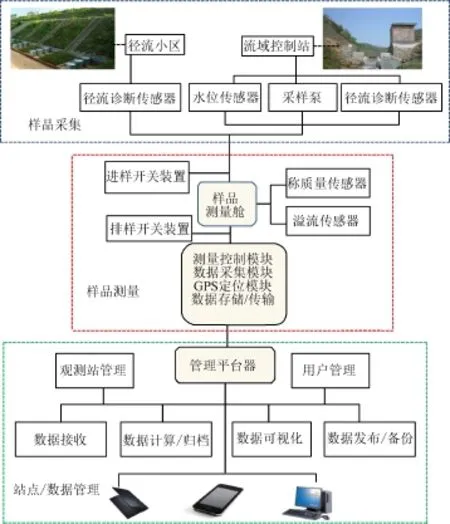
图1 仪器结构示意图Fig.1 Structure diagram of equipment
2.1.1 样品采集部分
样品采集首先是通过径流诊断传感器探测有无径流,若径流出现,则利用导流管路连接进样开关装置,使径流导入样品测量舱,进而进行径流量和含沙量的测量。若径流诊断传感器未探测到径流,则样品采集的相关部件休眠。对于径流小区而言,所采集的样品是样品采集期间的全部径流。而对于流域控制站而言,所采集的样品是全部径流的一部分,因此,在仪器机械构成上需要增加水位传感器和电机等功能部件,如图2所示。
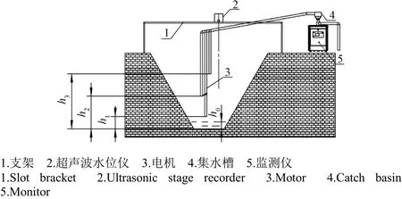
图2 流域控制站采样部分结构示意图Fig.2 Schematic diagram of sample component of monitoring station in watershed
2.1.2 样品测量部分
样品测量部分主要是利用连接在样品测量舱上的溢流传感器、称重传感器、进/排样开关装置、测量控制器和数据采集器等功能部件完成对径流样品体积和质量的精确测量,随之将测量数据存储到监测仪的存储卡并通过无线网络(GMS)发送到站点/数据管理云平台,如图3所示。

图3 样品测量部分结构示意图Fig.3 Schematic diagram of measuring component
2.1.3 站点/数据管理云平台
站点/数据管理云平台是基于“互联网+”框架建立的适用于从一台监测设备到无数台监测设备的径流泥沙监测及其数据管理云平台,其结构如图4所示。用户可自行布设专属的站点/数据管理云平台(私有平台),也可将监测设备连接到公共的站点/数据管理云平台(公有平台),站点/数据管理云平台通过开发站点管理、用户管理、远程数据接收、数据计算与汇编、数据可视化等功能模块,为使用者提供便捷、安全、自主的监测站/数据管理。
2.2 测量舱的结构和设计
测量舱是盛装所采集的待测径流泥沙样品的部件,其容积、几何形状、材质和表面处理与泥沙的粘附、沉积关系密切,而粘附、沉积的泥沙量直接影响待测样品体积和质量,进而影响含沙量测量的精度和准确度。所以,测量舱的容积、几何形状、材质选择、表面处理等就成为测量舱研制的重点。测量舱的结构如图5所示。
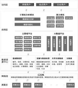
图4 站点/数据管理云平台示意图Fig.4 Schematic diagram of a cloud station/data management platform
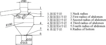
图5 测量舱结构示意图Fig.5 Schematic diagram of measuring chamber
1)容积的设计
测量舱容积的设计主要考虑3个因素,一是所采集的样品量对总体的代表性;二是所采集的样品量要能反映径流泥沙的变化过程;三是仪器完成一个测量周期需要的时间。综合分析以上3个因素,确定测量舱容积为5 L。
2)几何形状的设计
测量舱设计为形似“葫芦”的容器,其上、下两端口径较小,中部口径较大,变径部分为流线型圆滑过渡,不留“棱坎”。在测量舱的颈部设计一个溢流口,并连接一个溢流管,溢流口下沿所在的平面作为测量舱体积测量的上限。测量舱的下端与排样开关装置连接,当排样开关关闭时,排样开关装置的阀板应处于水平状态,作为测量舱体积量测的下限。
3)溢流口和溢流管的设计
溢流口是自动测量过程控制和径流泥沙体积测量的重要部分。当径流液到达溢流口的下沿后,后续的径流液就会从溢流口溢出,以保证测量舱的容积是一个定值,较之测量液面水位高度来计算体积的方法大幅度提高了体积测量的精度和准确度。其另一个作用是触发溢流传感器,进而触发进/排样开关装置。由于溢流口和溢流管一直是开放的,当进样开关关闭后,多余的径流泥沙会从溢流管自动排出,使样品测量舱的液面最终稳定在溢流口下沿所在的平面,所以将溢流口下沿所在的平面作为测量舱体积测量的上限。
4)材质选择与表面处理
测量舱和径流泥沙传输管线的材质和表面处理对径流泥沙的粘附、沉积作用影响很大。本研究选取不同的材料,如不锈钢、镀锌钢板、铝板、有机玻璃等,喷涂不同的表面处理材料,如超疏水纳米自洁防水剂、杜邦特氟龙材料、汽车面漆等,制作了多种测量舱和泥沙传输管线,通过对径流泥沙的粘附性检测,寻求泥沙粘附和沉积作用最低的材料和表面处理方法,最终确定采用汽车面漆喷涂方式处理的不锈钢板,其几乎无泥沙沉积和粘附。
2.3 测控流程设计
测控流程设计时需要考虑以下4个主要因素:
1)径流是随降雨而发生的随机事件,并且在以年为周期的时间范围内,其发生属于一个低频率事件。对于径流泥沙自动监测仪多数时间处于休眠状态是比较合理的选择。而当径流出现后需要将检测仪从休眠状态唤醒并转换为工作状态。
2)径流一旦发生,其历时长短是不可预知的,所以,要求监测仪可以无限制地重复测量。
3)选择合理的测量结束信号,控制监测仪在径流结束后由工作状态转换为休眠状态。
4)为了减少残留、称质量时的晃动对体积、质量测量的影响,需要在测量流程中设计“冲洗” “空淋” “静置”环节。
综合分析径流泥沙过程的特点、功能部件的结构、性能以及工作过程,设计测控流程及其控制电路如图6和7所示。
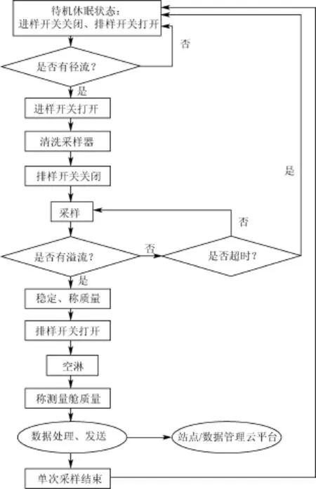
图6 测控流程示意图Fig.6 Measured and control flow diagram
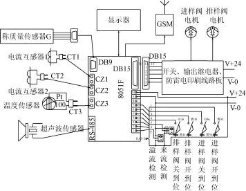
图7 测控流程电路图Fig.7 Measured and control circuit diagram
3 精度和准确度检测
为了检测该仪器的精度和准确度,进行了标准泥沙样品的测试试验。试验选用的是黄绵土,该土壤比重为2.65 mg/m3,含水量为10.94%。根据标定的测量舱体积配制不同浓度的标准泥沙样品,即0、2、4、6、8、10、20、30、40、50、60、70、80、90、100、150、200、250、300、400、500 kg/m3,每个浓度样品重复测量3次。结果表明,含沙量的测量值和实际值回归系数接近1,为0.95,决定系数为0.997(图8)。相对于实际值,测量值偏小,这可能是由于配制标准泥沙样品时的人为误差造成的,亦或是土壤含水量测量过程中的误差造成的。此外,分析监测结果的相对误差表明,相对误差波动范围为0.62%~14.00%,均值为3.67%。其中,低含沙量样品(2~10 kg/m3)测量的相对误差为7.00%,中含沙量样品(20~90 kg/m3)测量的相对误差为3.10%,高含沙量样品(100~300 kg/m3)测量的相对误差为2.61%(图9a)。对相对误差进行频率分布分析(图9b),发现大部分样本的相对误差较小,相对误差<10%的样本仅占样本总数的96.30%。以上结果表明,该监测仪对检验样本数据的预测准确度达到了较高水平,可准确的监测含沙量。
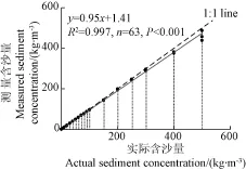
图8 实际含沙量与测量含沙量关系Fig.8 Relationship between actual and measured values of sediment concentration
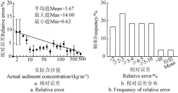
图9 含沙量的相对误差Fig.9 Relative error of sediment concentration
4 径流泥沙过程的实测分析
4.1 试验设计
为了验证该仪器对径流泥沙过程监测的宽泛性,2017年5月10日在黄土高原土壤侵蚀与旱地农业国家重点实验室人工模拟降雨大厅进行观测试验。试验小区为可调坡度的钢制土槽,小区规格长×宽×深=3.0 m× 1.0 m×0.5 m,土槽坡度为15°,供试土壤为黄绵土。小区布设完成后,在正式降雨试验进行之前,供试小区土壤表面均匀喷水后静置7 d,使土槽内部土壤水分的再分配达到应力均匀、土壤结构稳定。试验为次降雨,不设重复,降雨历时为240 min,降雨强度45、60、80和120 mm/h各持续60 min,从降雨开始至降雨结束对试验下垫面进行径流泥沙样品监测,据此获取径流过程中径流量和含沙量的变化曲线。
4.2 径流泥沙过程分析
图10给出了不同降雨强度下径流量和含沙量的变化曲线。由图10可见,随着时间的推移和降雨强度的增加,径流量和含沙量均呈现显著的同步增加趋势,径流量的波动范围为19~127 L/s,均值为75.5 L/s,含沙量的波动范围为4.6~275.1 kg/m3,均值为88.6 kg/m3。
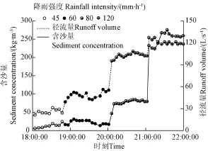
图10 径流量和含沙量的动态变化过程Fig.10 Dynamic change process of runoff volume and sediment concentration
其中,在降雨强度为45和60 mm/h的情况下,含沙量的变化并不明显,其波动范围为4.6~30.5 kg/m3。当降雨强度增加至80 mm/h时,水流中的含沙量在整个产流阶段迅速增加,含沙量的均值为76.7 kg/m3。当降雨强度增加至120 mm/h时,由于下垫面侵蚀沟的产生,水流中的含沙量均在200 kg/m3以上,最大值高达275.1 kg/m3。由此可见,本研究中的监测仪可以监测变幅较宽的径流量和含沙量,其弥补了现有仪器监测范围小的不足,具有一定的应用前景。
5 结 论
1)以获取水土流失过程数据为核心,基于经典的称重法原理,结合自动化控制技术、精密传感技术等现代科学技术,研制了一种适用于径流小区和流域控制站等多场景的径流泥沙全自动、全过程、高精度、实时监测的径流泥沙监测仪,并建立“互联网+”框架下的径流泥沙监测站点/数据管理云平台。相对于传统方法,此方法不受径流泥沙过程历时长短、泥沙颗粒粒径组成以及径流量、含沙量大小的限制。
2)对自行研制的监测仪进行精度和准确度检验,结果表明含沙量的真实值与测量值具有较好的一致性,含沙量的测量值和实际值的线性回归方程斜率高达0.95,测量的相对误差均值为3.67%,该方法监测误差小,可有效、准确地的监测径流泥沙含量。
3)通过土槽模拟试验监测了径流量和含沙量的动态过程曲线,监测到的径流量和含沙量的变化范围分别为19~127 L/s和4.6~275.1 kg/m3。由此可见,本研究中的监测仪具有较高的普适性,应用前景广泛,可以促进水土保持学科试验监测技术的发展,籍以深化土壤侵蚀过程、机理等水土保持学科基础研究,支撑水土流失防治等应用研究。
[1] 中华人民共和国水利部. 中国水土保持公报[R]. 中华人民共和国水利部,2013.
[2] Pimentel D C, Kounang N. Ecology of soil erosion in ecosystems[J]. Ecosystems, 1998, 1(5): 416-426.
[3] Lantican M A, Guerra L C, Bhuiyan S I. Impacts of soil erosion in the upper Manupali watershed on irrigated lowlands in the Philippines[J]. Paddy and Water Environment, 2003, 1(1): 19-26.
[4] Marques M J, Bienes R, Perez-Rodriguez R, et al. Soil degradation in Central Spain due to sheet water erosion by low-intensity rainfall events[J]. Earth Surface Processes and Landforms, 2008, 33(3): 414-423.
[5] Wren D G, Barkdoll B D, Kuhnle R A, et al. Field techniques for suspended sediment measurement[J]. Journal of Hydraulic Engineering, 2000, 126(2): 97-104.
[6] Zhao S L, Dorsey E C, Gupta S C, et al. Automated water sampling and flow measuring devices for runoff and subsurface drainage[J]. Journal of Soil and Water Conservation, 2001, 56(4): 299-306.
[7] Klik A, Sokol W, Steindl F. Automated erosion wheel: A new measuring device for field erosion plots[J]. Journal of Soil and Water Conservation, 2004, 59(3): 116-121.
[8] 曾为军,张云伟,陈岭,等. 基于计时与光照法的坡面径流量及含沙量动态检测系统[J]. 农业工程学报,2014,30(24):114-123.
Zeng Weijun, Zhang Yunwei, Chen Ling, et al. Dynamic measured system for hillslope runoff rate and sediment concentration based on time method and illumination method[J]. Transactions of the Chinese Society of Agricultural Engineering (Transactions of the CSAE), 2014, 30(24): 114-123. (in Chinese with English abstract)
[9] Pinson W T, Yoder D C, Buchanan J R, et al. Design and evaluation of an improved flow divider for sampling runoff plots[J]. Applied Engineering in Agriculture, 2004, 20(4): 433-437.
[10] 叶芝菡,刘宝元,路炳军,等. 径流小区集流桶含沙量全深剖面采样器的研制与试验[J]. 泥沙研究,2005(3):24-29.
Ye Zhihan, Liu Baoyuan, Lu Bingjun, et al. Design and testing of the depth profile sediment sampler for runoff plots[J]. Journal of Sediment Research, 2005(3): 24-29. (in Chinese with English abstract)
[11] 赵军,屈丽琴,赵晓芬,等. 称重式坡面径流小区水流流量自动测量系统[J]. 农业工程学报,2007,23(3):36-40.
Zhao Jun, Qu Liqin, Zhao Xiaofen, et al. Automated weighting system for measuring flow rate from runoff plots[J]. Transactions of the Chinese Society of Agricultural Engineering (Transactions of the CSAE), 2007, 23(3): 36-40. (in Chinese with English abstract)
[12] 曹建生,张万军. 小流域径流泥沙自动采集器的试验研究[J].农业工程学报,2009,25(1):45-49.
Cao Jiansheng, Zhang Wanjun. Experimental investigation on instrument for auto-sampling water from runoff and sediment in a small catchment[J]. Transactions of the Chinese Society of Agricultural Engineering (Transactions of the CSAE), 2009, 25(1): 45-49. (in Chinese with English abstract)
[13] 李续峰,张兴义,刘洪家. 径流泥沙混合装置研发[J]. 水土保持研究,2012,19(1):23-27. Li Xufeng, Zhang Xingyi, Liu Hongjia. Design of integrated equipment on runoff and sediment[J]. Research of Soil and Water Conservation, 2012, 19(1): 23-27. (in Chinese with English abstract)
[14] Einstein H A. The bed-load function for sediment transportation in open channel flows[J]. Technical Bulletins, 1950(71): 75-81.
[15] Guy B T, Dickinson W T, Rudra R P. The roles of rainfall and runoff in the sediment transport capacity of interrill flow[J]. Transactions of the American Society of Agricultural Engineers (Transactions of the ASAE), 1987, 30(5): 1378-1386.
[16] 雷廷武,赵军,袁建平,等. 利用γ射线透射法测量径流含沙量及算法[J]. 农业工程学报,2002,18(1):18-21.
Lei Tingwu, Zhao Jun, Yuan Jianping, et al. Determining sediment concentration in runoff flow with γ ray attenuation and the related theoretical algorithm[J]. Transactions of the Chinese Society of Agricultural Engineering (Transactions of the CSAE), 2002, 18(1): 18-21. (in Chinese with English abstract)
[17] 雷廷武,刘清坤,黄兴法,等. 伽玛射线测量径流泥沙含量算法中质量吸收系数优选及其对测量误差影响的分析[J]. 农业工程学报,2003,19(1):51-53.
Lei Tingwu, Liu Qingkun, Huang Xingfa, et al. Optimal choice of mass absorption coefficient and analysis ofits influence on measured error in algorithm of using gamma ray to measure runoff sediment concentration[J]. Transactions of the Chinese Society of Agricultural Engineering (Transactions of the CSAE), 2003, 19(1): 51-53. (in Chinese with English abstract)
[18] 高佩玲,雷廷武,邵明安,等. 小流域土壤侵蚀及径流过程自动测量系统的实验应用[J]. 农业工程学报,2005,21(10):164-166.
Gao Peiling, Lei Tingwu, Shao Ming’an, et al. Laboratory applications of an automated measuring system for soil erosion and runoff processes in small watershed[J]. Transactions of the Chinese Society of Agricultural Engineering (Transactions of the CSAE), 2005, 21(10): 164-166. (in Chinese with English abstract)
[19] 王辉,雷廷武,赵军,等. 坡面径流量与含沙量动态测量系统[J] . 农业机械学报,2005,36(1):79-82.
Wang Hui, Lei Tingwu, Zhao Jun, et al. System for dynamic measurements of hillslope runoff rate and sediment concentration[J]. Transactions of the Chinese Society of Agricultural Machinery (Transactions of the CSAM), 2005, 36(1): 79-82. (in Chinese with English abstract)
[20] 黄建龙,高艳雯,陈文科. 基于Lab VIEW的振动式悬移质测沙系统[J]. 兰州理工大学学报,2007,33(2):46-49.
Huang Jianlong, Gao Yanwen, Chen Wenke. Vibratory suspending sandiness measuring system based on Lab VIEW[J]. Journal of Lanzhou University of Technology, 2007, 33(2): 46-49. (in Chinese with English abstract)
[21] Bonta J V. Water sampler and flow measurement for runoff containing large sediment particles[J]. Transactions of the American Society of Agricultural Engineers (Transactions of the ASAE), 1999, 42(1): 107-144.
[22] 方彦军,唐懋官. 超声衰减法含沙量测试研究[J]. 泥沙研究,1990(2):1-12.
Fang Yanjun, Tang Maoguan. Ultrasonic attenuation method for measuring sediment concentration[J]. Journal of Sediment Research, 1990(2): 1-12. (in Chinese with English abstract)
[23] 李小昱,雷廷武,王为. 电容式传感器测量水流泥沙含量的研究[J]. 土壤学报,2002,39(3):429-435.
Li Xiaoyu, Lei Tingwu, Wang Wei. Capacitance sensor measuring sediment concentration in water current[J]. Acta Pedologica Sinica, 2002, 39(3): 429-435. (in Chinese with English abstract)
[24] 沈逸,李小昱,雷廷武,等. 电容式水流泥沙含量传感器数据融合的研究[J]. 华中农业大学学报,2004,23(4):459-462.
Shen Yi, Li Xiaoyu, Lei Tingwu, et al. Data fusion of capacitance sensor of sediment concentration in water current[J]. Journal of Huazhong Agricultural University, 2004, 23(4): 459-462. (in Chinese with English abstract)
[25] Campbell C G, Laycak D T, Hoppes W, et al. High concentration suspended sediment measurements using a continuous fiber optic in-stream transmissometer[J]. Journal of Hydrology, 2005, 311(1/2/3/4): 244-253.
[26] Downing J. Twenty-five years with OBS sensors: The good, the bad, and the ugly[J]. Continental Shelf Research, 2006, 26(17/18): 2299-2318.
[27] 王娅娜,蔡辉,马洪蛟,等. 红外实时测沙仪研制及其应用[J]. 海洋工程,2007,25(3):132-135.
Wang Yana, Cai Hui, Ma Hongjiao, et al. Research on real-time wireless sediment measurement system and its application in annular flume[J]. The Ocean Engineering, 2007, 25(3): 132-135. (in Chinese with English abstract)
[28] 王文坚. 新型现场激光测沙仪[J].水利水电快报,2001(16):22-23.
[29] 唐兆民,何志刚,韩玉梅. 悬浮泥沙浓度的测量[J]. 中山大学学报:自然科学版,2003,42(增刊2):244-247.
Tang Zhaomin, He Zhigang, Han Yumei. The measurement on suspended sediment concentration[J]. Acta Scientiarum Naturalium Universitatis Sunyatseni, 2003, 42(Suppl.2): 244-247.
[30] 王艳姣. 基于悬浮泥沙影响的水深遥感方法研究[D]. 南京:南京师范大学,2006.
Wang Yanjiao. Application of Remote Sensing Technology to map Water Depth by Weakening the Influence of Suspended Sediment[D]. Nanjing: Nanjing Normal University, 2006. (in Chinese with English abstract)
[31] Stroosnijder L. Measurement of erosion: is it possible?[J]. Catena, 2005, 64: 162-173.
Development of real-time and automatic measuring equipment for runoff and sediment
Zhan Xiaoyun1,2, Guo Minghang1,2, Zhao Jun1,2※, Zhao Xianghui3
(1. State Key Laboratory of Soil Erosion and Dryland Farming on Loess Plateau, Northwest A&F University, Yangling 712100, China; 2. Institute of Soil and Water Conservation, CAS&MWR, Yangling 712100, China; 3. Xi’an San Intelligent Technology Co’LTD, Xi’an 710075, China)
Monitoring processes of runoff and sediment are the foundation of the dynamic assessment of soil erosion. Runoff volume and sediment concentration are 2 important hydrodynamic parameters to forecast slope runoff variation, reveal soil erosion mechanism and find out movement rule of soil in the field. However, the equipment which can be used widely to monitor precisely the runoff volume and sediment concentration at the same time is lacking. In view of the inaccuracy or the lack of equipment for automatic monitoring of runoff and sediment processes, real-time and automatic measuring equipment with high precision was explored in this study. The equipment could be applied to multi-scenario, including runoff plot and watershed. In our study, firstly, through the integration of signal sensing and automatic control technology, physical characteristics driving the operation of the equipment were extracted and converted into TT&C signals to automatically monitor runoff and sediment yield processes. On the one hand, continuous flow of runoff and sediment was discretized by optimizing the design of equipment overall structure and the functional unit. On the other hand, optical material of sampling device was used and the most reasonable shape and surface treatment of sampling device was designed, to reduce the influences of sediment adhesion and deposition on the accuracy and precision of measurement. Finally, based on “internet+”framework, a cloud station/data management platform was established, including station management, data integration, calculation and analysis, and application service. The equipment was able to get the values of runoff volume and sediment concentration synchronously, which overcame the limitation of tradition method. Furthermore, the reliability and applicability of the equipment were validated by the simulation experiment, and the results showed that the relative error of sediment concentration was averaged as 3.67%. Specifically, the relative error was averaged as 7.00%, when the sediment concentration was less than10 kg/m3, and when the sediment concentration varied from 20 to 90 kg/m3and from 100 to 300 kg/m3, the averaged relative errors were 3.10% and 2.61% respectively. The relative error greater than 10% accounted for only 3.70% of the total samples, while the relative error of the remaining 96.3% was less than 10%. The results also showed that the slope of linear regression between measured and actual sediment concentration was close to 1, and the coefficient of determination was up to 0.997. The research demonstrates that the equipment can detect precisely the dynamic processes of runoff volume and sediment concentration. We also monitored the dynamic process of runoff volume and sediment concentration through soil bin simulation experiment, and found that runoff volume varied from 19 to 127 L/s, with an average of 75.5 L/s, sediment concentration ranged from 4.6 to 275.1 kg/m3, and sediment concentration in the single rainfall was, on average, 88.6 kg/m3. The finding demonstrates that the equipment is capable of monitoring the large variation of runoff and sediment concentration, and can be used to complex field observations, and therefore, the self-designed equipment for auto-sampling water from runoff has a good prospect. This research can provide new techniques and methods for water and soil loss study, and promote the automation and informatization in water and soil loss monitoring.
soils; erosion; runoff; sediment concentration; automatic monitoring
10.11975/j.issn.1002-6819.2017.15.014
S157; TP216
A
1002-6819(2017)-15-0112-07
2017-04-26
2017-07-12
国家自然科学基金项目(41371278;41503078);黄土高原土壤侵蚀与旱地农业国家重点实验室重要方向创新项目(A314021403-C3)
展小云,女,博士,主要从事水土流失过程与水土保持研究。杨凌 西北农林科技大学黄土高原土壤侵蚀与旱地农业国家重点实验室,712100。Email:zhanxiaoyun2005@163.com
※通信作者:赵军,男,高级工程师,主要从事科研信息化与装备研究。杨凌 西北农林科技大学黄土高原土壤侵蚀与旱地农业国家重点实验室,712100。Email:zhaojun629@vip.sina.com
