两种工程堆积体边坡模拟径流侵蚀对比研究*
2017-06-07丁文斌李叶鑫史东梅蒋光毅汪三树蒋
丁文斌李叶鑫史东梅†蒋光毅汪三树蒋 平
(1 西南大学资源环境学院,西南大学水土保持生态环境研究所,重庆 400716)
(2 重庆市水土保持生态环境监测总站,重庆 401147)
(3 重庆市水利电力勘测设计研究院,重庆 400020)
两种工程堆积体边坡模拟径流侵蚀对比研究*
丁文斌1李叶鑫1史东梅1†蒋光毅2汪三树3蒋 平3
(1 西南大学资源环境学院,西南大学水土保持生态环境研究所,重庆 400716)
(2 重庆市水土保持生态环境监测总站,重庆 401147)
(3 重庆市水利电力勘测设计研究院,重庆 400020)
基于对重庆市城镇建设中工程堆积体野外调查结果,选择广泛存在的紫色土和黄沙壤工程堆积体为研究对象,采用野外实地放水冲刷试验,对比分析了不同土石比及坡度的工程堆积体边坡径流侵蚀过程。结果表明:(1)工程堆积体土壤入渗率随冲刷过程呈先快速减小、后逐渐稳定的变化趋势,且波动幅度大小随冲刷流量的不同出现差异,下垫面稳定入渗率均在0.4~1.7 mm min-1之间。(2)不同下垫面堆积体产流率随冲刷时间均呈先增加后稳定的谷峰交织变化趋势且随放水流量增大而显著增强;在相同放水流量时,黄沙壤堆积体平均产流率最大可为紫色土堆积体的1.89倍。(3)不同下垫面堆积体径流含沙量随冲刷时间呈先增加后稳定的波动趋势;径流含沙量在不同流量条件下介于0.21~1 278.49 g L-1;冲刷过程中坡面面蚀向沟蚀的转化对径流含沙量有显著影响,最大可增加13.73倍;堆积体坡面侵蚀过程存在突变期、活跃期和稳定期3个阶段,细沟发生的偶然性和随机性对产沙量波动贡献率最大。(4)工程堆积体在不同放水流量条件下侵蚀泥沙颗粒粒径分布差异性明显,紫色土堆积体最大侵蚀泥沙颗粒均大于黄沙壤堆积体。研究结果可为重庆市城镇建设工程堆积体新增水土流失量预测和植被生态恢复提供重要科学依据。
产流产沙;入渗;工程堆积体;边坡;径流侵蚀;岩土侵蚀
随着社会经济快速发展,开挖地表、破坏土壤原有结构、重塑地形地貌等各种人为活动所造成的土壤侵蚀的严重性已超过农民陡坡开荒等问题[1-2]。工程建设过程中形成的堆积体是一种具有一定含石量的极端不均匀的特殊工程地质材料,其物质组成复杂、结构松散、黏聚力差,在降雨及地表径流冲刷下,极易发生剧烈的水土流失以及滑坡、泥石流等地质灾害。与耕地、林地等侵蚀地貌单元相比,生产建设项目形成的堆积体造成的泥沙量大[3],其土壤侵蚀速率可达原地貌的2倍~40 000倍[4]。因此,研究和分析工程堆积体坡面侵蚀的发生和发展以及阐明坡面侵蚀机理对有效控制水土流失具有重要意义。国外学者对生产建设项目水土流失较为关注,Evans等[5]分析了煤矿区工程堆积体对河流泥沙量的影响; Katridzidakis 和Pipinis[6]认为高速公路高陡边坡在采用植被护坡措施下可以有效地绿化环境和减少水土流失量。我国在2008年提出《开发建设项目水土流失防治标准》并将项目区水土流失防治标准划分为国家级、省级和其他区域3个等级[7]。2011年在《中华人民共和国水土保持法》明确提出对取土场、开挖面和废弃的砂、石、土存放地的裸露土地,必须植树种草,防止人为水土流失[8]。国内研究主要集中在采矿区水土流失形式、形成机制及影响因素[9],城镇建设侵蚀过程及特点[10],公路建设侵蚀环境及侵蚀机制[11-12]和铁路建设侵蚀特点[13]等。四川盆地及周围山地丘陵区是我国暴雨中心之一,对该地生产建设项目产流产沙及其危害特征研究较少。本文以重庆市主要土壤类型紫色土和黄沙壤分布区的生产建设项目工程堆积体为研究对象,通过野外放水冲刷试验对不同含石量工程堆积体下垫面的入渗、产流、产沙动态过程及机理进行了深入研究,分析了不同水力条件下坡面产流产沙过程,阐述了工程堆积体坡面侵蚀形态演变过程及侵蚀泥沙颗粒分布特征,以期为重庆市生产建设项目工程堆积体水土流失规律研究及生态修复提供科学依据。
1 材料与方法
1.1 试验材料
供试工程堆积体来源于重庆北碚房地产开挖土壤,紫色土弃渣母质为中生代侏罗系沙溪庙组灰棕紫色沙泥页岩,黄沙壤弃渣母质为棕黄沙泥岩。试验于2012年8月—11月在西南大学生产建设项目水土流失定位试验基地进行,选择偏土质(含石量20%)和土石质(含石量40%)工程堆积体下垫面进行野外放水冲刷试验,其粒径分布如图1所示。将工程堆积体按设计含石量混合均匀后填入试验小区,然后用铁耙将其平整,供试材料小区基本物理性质见表1。
1.2 试验方法
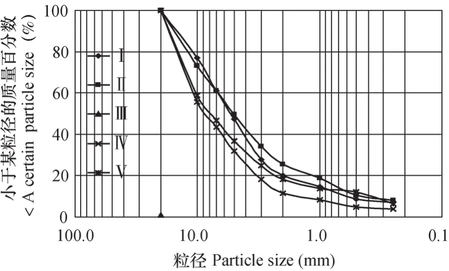
图1 不同下垫面条件下工程堆积体粒径分布曲线Fig. 1 Particle size distribution curve of engineering taluses different in underlying surface

表1 不同工程堆积体下垫面小区基本情况Table 1 General information of the sites of the engineering taluses different in underlying surface
根据重庆市暴雨发生频率特点和当地径流小区观测资料来确定设计流量。本试验设计3个放水流量,分别为5、10、15 L min-1,设计冲刷时间为60 min。在每次放水冲刷前,测定工程堆积体下垫面含水量、容重和颗粒组成等物理指标,同时率定放水流量n(n≥3)次,以保证实际放水流量与设计流量误差不超过5%。供水设备采用定水头装置,首先使水进入一个水头恒定的储水箱(容积为2 m3),然后流经稳压水泵及流量计后流入一个簸箕型溢流槽,以保证水流以薄层均匀的形式向下流动;在溢流槽上端通过阀门控制流量,溢流槽下面铺透水纱布,以防水流过度侵蚀,其具体布置见图2。自坡面开始产流,10 min内每1 min接取一次径流泥沙样,10 min后每3 min接取一次,用量筒或标准测样桶测定径流泥沙样体积,并从中均匀取样500 ml,烘干后计算含沙量。收集每次试验所有径流泥沙样,充分搅拌均匀后提取5 L样品,带到实验室内沉淀、风干、测定侵蚀泥沙颗粒组成。

图2 放水冲刷试验装置示意图Fig. 2 Schematic diagram of the apparatus for the scouring experiment
工程堆积体下垫面入渗率K按式(1)计算[14]。

式中,K为工程堆积体下垫面入渗率(mm min-1);I为放水强度(mm min-1);θ为下垫面坡度(°);R为第i次取样的径流量(ml);S为过水断面积(m2);t为径流取样间隔时间(min)。
工程堆积体下垫面侵蚀模数M为次冲刷试验中产沙量与冲刷时间和小区面积的比值,按式(2)计算。

式中,M为侵蚀模数(g min-1m-2);m为侵蚀产沙量(g);a为小区水平投影面积(m2);t为产流时间(min)。
2 结 果
2.1 工程堆积体下垫面入渗特征变化
工程堆积体下垫面入渗特征直接影响坡面径流和冲刷过程。由图3可知,在冲刷前10 min内下垫面入渗率减小最快,10~30 min减小变慢,在30 min后趋于稳定。原因在于冲刷初期,下垫面初始含水率低且土壤对水分的吸力大,堆积体坡面具有较大入渗率;随着冲刷时间进行,下垫面含水率增大且坡面大孔隙被细小颗粒和水分填满,导致土体孔隙度和大孔隙连通性变差,工程堆积体入渗率减小直至稳渗状态。
不同放水流量条件下工程堆积体入渗率的波动程度不同。在流量为5 L min-1时,工程堆积体平均入渗率在0.5~0.9 mm min-1之间,变化幅度为10.25%~30.62%;随着流量的增大,前10 min内入渗率骤减,其减小幅度可达到83%。在相同坡度、含石量、流量条件下,紫色土和黄沙壤堆积体平均入渗率存在显著差异(p<0.05)。当下垫面坡度为35°、含石量为40%时(图3b),紫色土堆积体平均入渗率可由0.56 mm min-1(5 L min-1)增加至0.74 mm min-1(10 L min-1)和1.07 mm min-1(15 L min-1),黄沙壤堆积体平均入渗率依次为0.64、1.13、1.53 mm min-1;40°黄沙壤堆积体平均入渗率依次为40°紫色土堆积体的0.90倍,0.71倍和1.12倍(图3c),30°偏土质黄沙壤堆积体平均入渗率最大,是同一坡度紫色土堆积体的1.72倍(图3a)。对平均入渗率与放水流量的统计分析(表2)表明,平均入渗率与放水流量均呈幂函数关系,决定系数R2均在0.6以上,回归效果显著。
综上可知,体育游戏能够促进学前儿童成长。而为了落实好学前儿童体育游戏创新活动设计与创新,教师应遵从趣味性、自由性、竞争性、可变性体育游戏创编活动设计原则,并注重设计器械类游戏、对抗类游戏、角色类游戏、体能类游戏等多种多样的体育游戏,利用丰富多彩的体育游戏培养学前儿童团队意识,完善儿童人格,让学前儿童从小树立起体育运动意识和观念,健康成长。
2.2 工程堆积体下垫面径流变化特征
分析不同工程堆积体下垫面产流率变化规律对深入认识坡面侵蚀过程具有重要意义。不同下垫面产流率均表现为随冲刷时间呈先增加后稳定波动变化趋势(图4)。工程堆积体坡面产流率在产流初期(0~6 min)存在不同程度的跳跃或突变,在5 L min-1流量下分别增加0.12~0.57 L min-1,而在15 L min-1流量下可迅速增加至3.7~11 L min-1,产流突变系数最大可达11.11,最大产流率为13.6 L min-1;后期下垫面产流率伴随着较小波动而逐渐趋于稳定,波动幅度仅在0.87~1.32之间。
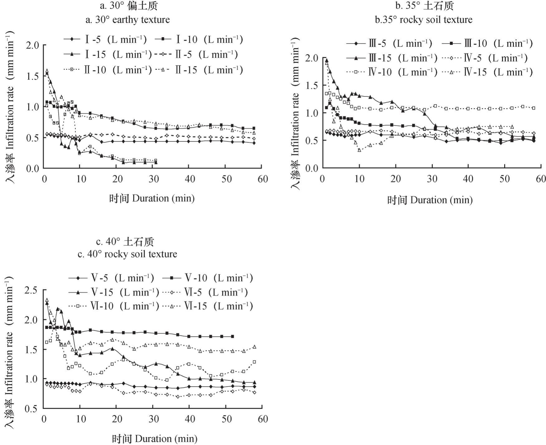
图3 不同放水流量条件下不同下垫面入渗率随冲刷时间的变化Fig. 3 Variations of the runoff rate with scouring going on relative to scouring flow rate

表2 不同下垫面平均入渗率与放水流量的关系Table 2 Relationships between average water infiltration rate and scouring flow rate on taluses different in underlying surface
对相同物质组成和堆放坡度的工程堆积体而言,放水流量是影响坡面产流率的主要因素。当堆积体坡面坡度为30°时,随放水流量的增大黄沙壤堆积体产流率分别为0.26、1.95、3.71 L min-1,紫色土堆积体产流率在0.58~9.83 L min-1之间,35°土石质紫色土和黄沙壤堆积体产流率最大值分别为6.55和6.31 L min-1,最小值分别为0.67和0.22 L min-1,40°紫色土和黄沙壤堆积体产流率的最大值与最小值分别相差6.78倍和37.40倍。由表3可知,不同工程堆积体下垫面产流率与放水流量均呈线性关系,决定系数R2均在0.79以上,F>F (1,5)0.05=6.61,说明产流率与放水流量显著相关。
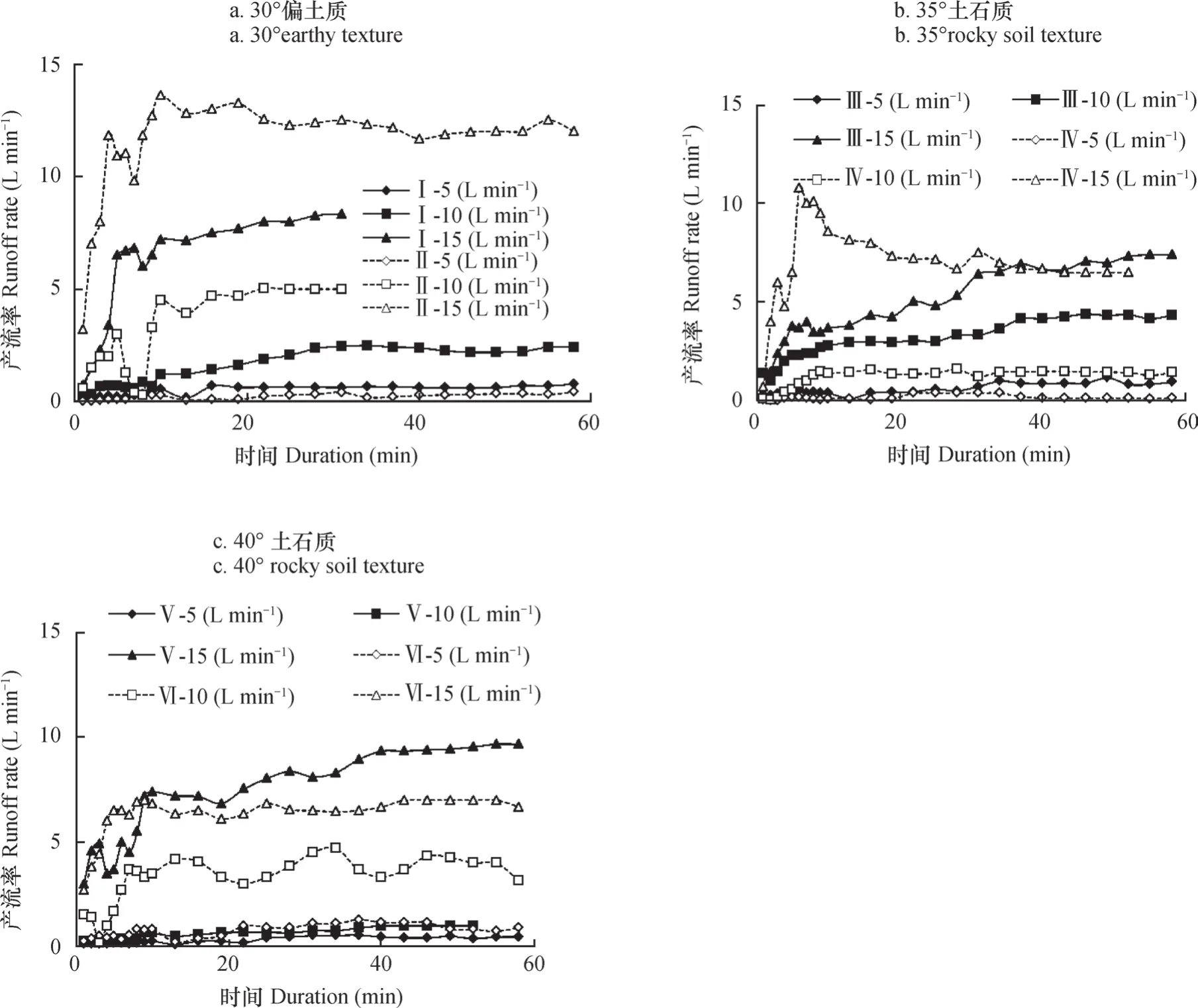
图4 不同放水流量条件下不同下垫面产流率随冲刷时间的变化Fig. 4 Variations of sediment contents with scouring going on relative to scouring flow rate

表3 不同工程堆积体下垫面产流率与放水流量的关系Table 3 Relationships between runoff rate and scouring flow rate on taluses different in underlying surface
2.3 不同工程堆积体下垫面侵蚀产沙变化
2.3.1 下垫面含沙量变化特征 对于特定的工程堆积体下垫面,径流冲刷能力决定其侵蚀产沙过程。在不同水力冲刷条件下,各下垫面径流含沙量随冲刷时间的变化趋势(图5)可概括为以下三点:
(1)不同工程堆积体下垫面含沙量均随冲刷时间呈先增加后稳定的波动趋势。在冲刷初期(0~6 min)由于径流冲刷能力弱,仅有细小、松散的土壤颗粒向坡下运动,径流含沙量在0.21~7.93 g L-1(5 L min-1)、2.65~448.4 g L-1(10 L min-1)、21.15~1 278 g L-1(15 L min-1)之间;随着细小颗粒逐渐被冲刷流失,堆积体中粗大砾石被架空在坡面上,在水力和重力综合作用下发生坍塌,造成局部泥沙淤积,使含沙量在短时间内迅速减小;但随着坡面径流的不断汇集和冲掏,堵塞的泥沙被冲开并以浑浊的水流顺坡而下,含沙量可明显增加1.29倍~13.73倍。随着坡面冲刷过程,下垫面侵蚀沟呈现沟头前进和沟槽加宽加深现象并进入形成、坍塌的反复阶段,直到径流含沙量趋于一个稳定值。
(2)工程堆积体下垫面含沙量随放水流量增大而明显增大,不同流量之间差异显著。当放水流量分别为5、10、15 L min-1,30°紫色土堆积体的平均含沙量分别为6.12、15.20、115.18 g L-1,即15 L min-1流量下的平均含沙量是10 L min-1的7.58倍,是5 L min-1的18.81倍,30°黄沙壤堆积体则分别为0.77、343.5、849.9 g L-1。
(3)对物质组成和堆放坡度相同的工程堆积体而言,5 L min-1流量下黄沙壤堆积体平均含沙量小于紫色土堆积体(除40°以外),其他流量下黄沙壤堆积体平均含沙量均远大于紫色土堆积体且随放水流量的增加愈加显著。当放水流量为10 L min-1时,35°土石质黄沙壤平均含沙量为133.76 g L-1,是35°土石质紫色土弃渣的5.56倍,15 L min-1流量下则为11.41倍。

图5 不同放水流量条件下不同下垫面含沙量随冲刷时间的变化Fig. 5 Erosion sediment concentration different in underlying surface with scouring going on relative to scouring flow rate
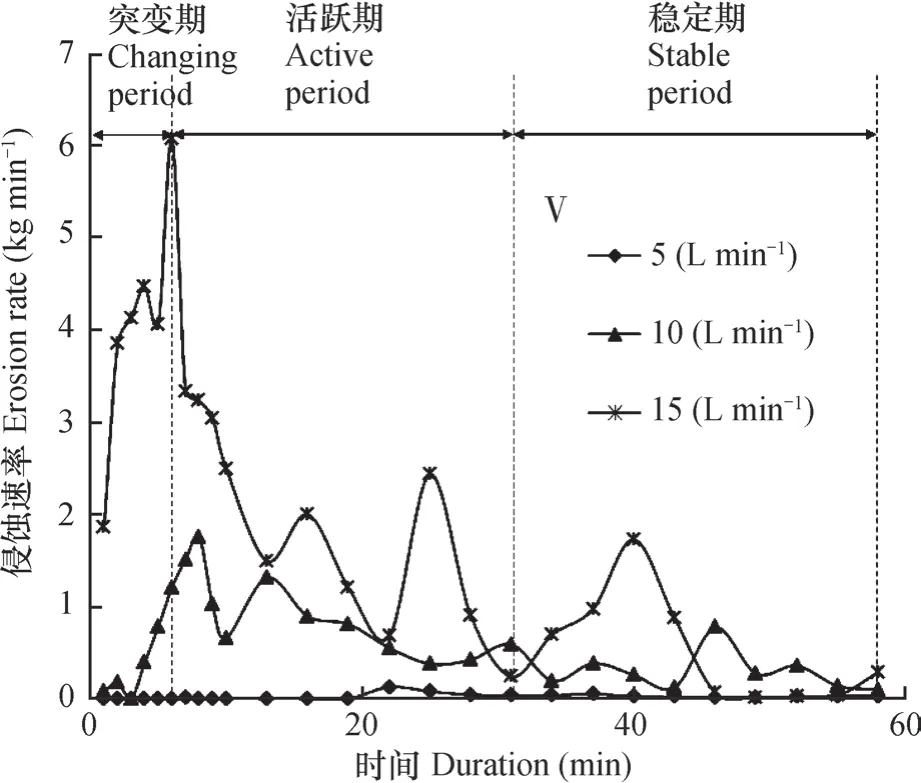
图6 不同放水流量条件下侵蚀速率随冲刷时间的变化Fig. 6 Variation of erosion rate with scouring going on relative to scouring flow rate
突变期发生在产流初期(0~6 min),以坡面面蚀为主;随着放水流量增大,径流侵蚀动力及挟沙能力明显增强,工程堆积体侵蚀速率突变愈加明显且发生愈早,其突变值在0.21~4.21 kg min-1之间。活跃期发生在产流后6~31 min内,为面蚀向细沟侵蚀过渡阶段。工程堆积体侵蚀速率(15 L min-1)由6.07 kg min-1减小至2.50 kg min-1。随后由于侵蚀沟形成与坍塌发育,降低了坡面供沙能力,侵蚀速率减小并伴有多个峰谷值。稳定期发生在产流31 min后,由于侵蚀沟发育成熟,工程堆积体下垫面形态基本稳定,产沙量趋于稳定。
2.4 工程堆积体下垫面侵蚀泥沙粒径和侵蚀模数变化
侵蚀泥沙颗粒是最深入反映坡面侵蚀变化过程的因子[17],揭示冲刷过程中最易侵蚀的泥沙颗粒分布特征对工程堆积体的生态恢复与重建具有重要指导意义。本文以40°土石质紫色土和黄沙壤堆积体分析不同流量条件下的泥沙粒径变化(图7)。由图可知,在不同水力冲刷条件下侵蚀泥沙颗粒粒径分布差异性明显,紫色土堆积体的最大侵蚀泥沙颗粒均大于黄沙壤。黄沙壤堆积体下垫面(Ⅵ)在不同放水条件下的侵蚀泥沙颗粒主要分布在0.1~0.5 mm之间(77.76%以上),下垫面侵蚀颗粒最大粒级为10~20 mm。而紫色土弃渣堆积体(V)侵蚀泥沙颗粒粒径主要分布在2~10 mm (54.06%~59.18%),并随着流量增大对大颗粒弃渣搬运能力增强,侵蚀泥沙颗粒的分布特征趋于坡面原始颗粒,造成弃渣堆积体坡面粗化现象更明显。
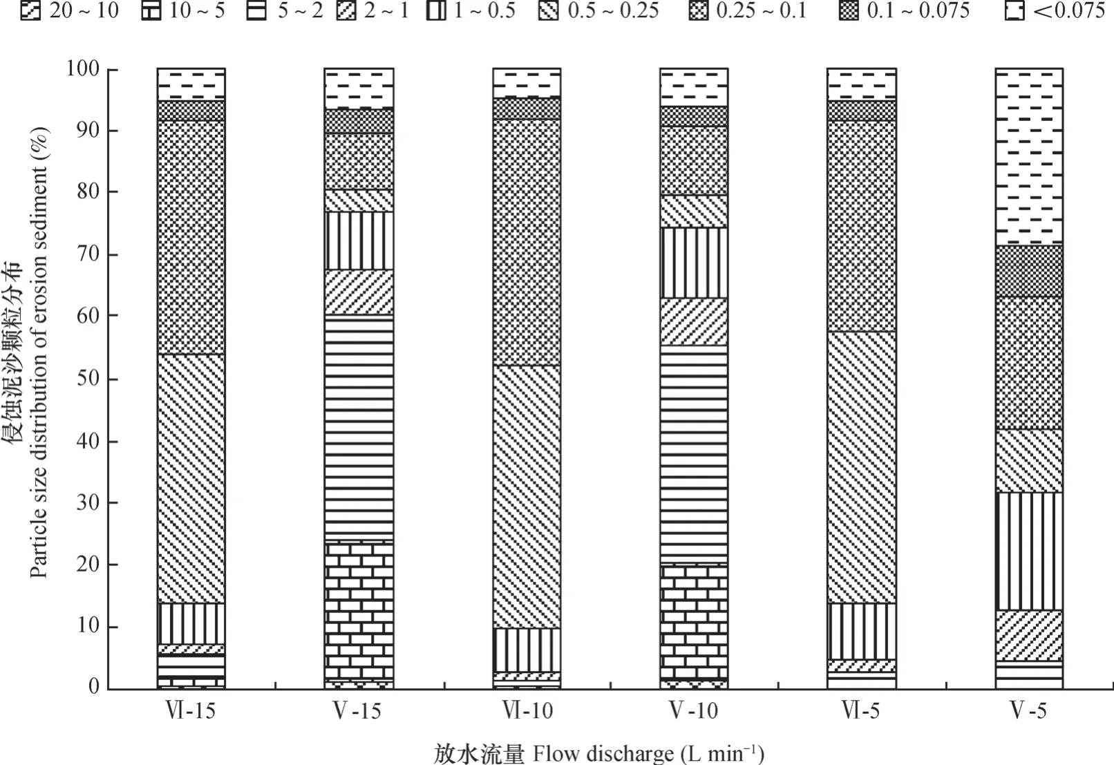
图7 不同放水流量条件下侵蚀泥沙颗粒分布Fig. 7 Particle size distribution of erosion sediment relative to scouring flow rate
下垫面侵蚀模数为次冲刷试验的侵蚀产沙量,可反映不同水力条件下工程堆积体下垫面侵蚀强度。由表4分析可知,侵蚀模数随放水流量增大而显著增大,二者具有较好的相关性;在相同流量条件下,黄沙壤堆积体的侵蚀模数大于紫色土堆积体且随流量增大而更加显著。侵蚀模数和放水流量的关系可以用幂函数方程很好地描述,决定系数R2均在0.80以上。

表4 不同下垫面侵蚀模数与放水流量的关系Table 4 Relationships between erosion modulus and scouring flow rate
3 讨 论
3.1 工程堆积体侵蚀发育过程变化
工程堆积体下垫面属于典型的非均质多孔介质,是介于土体与岩体之间的一种特殊土石混合体,具有物质组成复杂、结构松散以及颗粒分布不规则等特性[18],在径流冲刷下极易发生水土流失。相关研究表明,不同水力条件下坡面产流率表现为先增加后稳定的波动趋势[19-21],重力侵蚀是影响坡面产沙波动的主要因素,重力侵蚀引起的侵蚀沟坍塌将导致坡面径流含沙量和产沙量呈多峰多谷的变化过程[21~23]。从本研究看,坡面产流率和侵蚀速率随冲刷时间呈现多个峰谷值,随放水流量的增大首个峰值出现地更早且更大,侵蚀沟发育更快;小流量条件下的坡面径流率和侵蚀速率的峰谷差值均较小,这说明堆积体坡面侵蚀过程中影响最大的是降雨形成的地表径流强度,这一研究结论与张乐涛等[24]对工程堆积体陡坡土壤侵蚀过程研究一致。本文研究侧重于堆积体坡面产流产沙的过程变化,对重力侵蚀的影响未进行深入研究,这将是后续研究的重点。
张永东等[25]研究表明,细沟侵蚀的发育过程主要表现为溅蚀-跌坑-侵蚀穴-断续细沟-连续细沟。本研究表明侵蚀产沙过程具有明显的阶段性,根据侵蚀速率的变化过程将坡面侵蚀过程划分为突变期、活跃期和稳定期3个阶段,分别对应面蚀向沟蚀转化、细沟侵蚀和细沟侵蚀衰退阶段,其中突变期和活跃期受重力作用影响较大,细沟发生的偶然性和随机性对产沙量波动的贡献率最大,是导致径流含沙量骤变的主要原因。本研究表明,不同工程堆积体下垫面侵蚀模数随放水流量呈显著增加的幂函数关系,可以根据放水流量来估算不同城镇建设项目工程堆积体的侵蚀模数。但由于工程堆积体类型及所处环境条件不同,松散堆积体坡面侵蚀形态演变过程表现出较大差异性,下垫面物质组成和侵蚀动力对堆积体土壤侵蚀发育过程的影响有待今后深入研究。
3.2 工程堆积体水土流失防治措施
大量研究表明,侵蚀泥沙颗粒中黏粒含量与降雨量呈正相关,其主要原因是颗粒起动所需的拽引力与颗粒大小成反比[17]。Warrington等[26]着重研究重度侵蚀和轻度侵蚀下泥沙颗粒组成的变化。肖培青和郑粉莉[26]研究表明,降雨强度对侵蚀泥沙颗粒组成的影响不甚明显,侵蚀泥沙中黏粒含量随细沟水流流速和细沟侵蚀产沙量的增大而增加。本研究结果表明,黄沙壤堆积体在不同水力条件下易侵蚀颗粒粒径均分布在0.1~0.5 mm,所占比例因放水流量略有差异,这与肖培青和郑粉莉[27]的研究结论一致;而紫色土堆积体在小流量时易侵蚀颗粒为<1 mm的土体,其他流量为2~10 mm。
研究表明,工程堆积体极易产生水土流失,及时有效的防护措施是防治水土流失的关键[6]。Jon[28]阐述了工程施工区的土壤侵蚀控制原则,提出沙篱笆、沉沙池等措施可以减少工程施工区的产沙量。Hancock等[29]研究认为在弃土堆坡面上适当设置鱼鳞坑,可以将水土流失减少至原来的1/5。牛耀彬等[30]研究结果表明,在同一坡面,水平阶措施防护效果优于鱼鳞坑,但2种措施的防护效益均具有时效性。因此,本文认为通过布设排水沟、截水沟等工程措施可以有效地分散坡面径流,控制水流进入松散堆积体的侵蚀敏感地带,以有效减少下垫面细小颗粒物质的流失;同时注重植被覆盖对坡面的降雨击溅作用,关注植物根系对工程堆积体中细小物质的固持作用,以最大程度地减小土壤侵蚀的发生,促进工程堆积体的自然生态修复能力。
4 结 论
本研究采用野外实地放水冲刷试验,对比分析了不同土石比及坡度的工程堆积体边坡径流侵蚀过程。结果表明:土壤入渗速率随冲刷过程呈先快速减小后逐渐稳定的趋势,工程堆积体稳定入渗率主要影响因素为弃渣自身结构(颗粒组成,含石量等)。不同下垫面产流率随冲刷过程均呈先增加后稳定的多峰多谷变化趋势。工程堆积体坡面侵蚀过程分为突变期、活跃期和稳定期3个阶段。本研究同时表明,不同下垫面含沙量随冲刷时间呈先增加后稳定的波动趋势,累计产沙量与累计径流量具有较好的幂函数关系;冲刷过程中细沟发生的偶然性和随机性对产沙量波动贡献率最大,是导致径流含沙量骤变的主要原因。工程堆积体侵蚀模数随放水流量增大而显著增大,不同水力冲刷条件下侵蚀泥沙颗粒粒径分布差异性明显,紫色土堆积体的最大侵蚀泥沙颗粒均大于黄沙壤。
[1] Mathys N,Klotz S,Esteves M,et al. Runoff and erosion in the Black Marls of the Freneh AIPs: Observations and measurements at the Plot seale. Catena,2005,63(2/3):261—281
[2] 朱波,莫斌,汪涛,等. 紫色丘陵区工程建设松散堆积物的侵蚀研究. 水土保持学报,2005,19(4):193—195
Zhu B,Mo B,Wang T,et al. Studies on soil erosion from loose construction deposits in hilly areas of purple soil(In Chinese). Journal of Soil and Water Conservation,2005,19(4):193—195
[3] Kaunfman M M. Erosion control at construction sites:The science-policy gap. Environmental Management,2000,26(1):89—97
[4] McClintock K,Harbor J M. Modeling potential impacts of land development on sediment yields. Physical Geography,1995,16:359—370
[5] Evans K G,Martin P,Moliere D R,et al. Erosion risk assessment of the Jabiluka Mine site,Northern Territory,Australia. Journal of Hydrologic Engineering,2004,11/12:512—522
[6] Katridzidakis M,Pipinis E,Liapis A,et al. Restoration of slopes disturbed by a motorway company:Egnatia Odos,Greece// Stokes A,Spanos I,Norris J E. et al. eds. Eco-and ground bio-engineering. Berlin Germany:Springer Netherlands 2006,103:401—409
[7] 开发建设项目水土流失防治标准(GB 50433-2008).中华人民共和国水利部,2008
Ministry of Water Resources of the People’s Republic of China. Standard for prevention and control of soil and water loss in development and construction projects(GB 50433-2008)(In Chinese).2008
[8] 中华人民共和国水土保持法.北京:中国法制出版社,2011
Soil and water conservation law of the People’s Republic of China(In Chinese). Beijing:China Law Press,2011
[9] 李文银,王治国,蔡继清.工矿区水土保持.北京:科学出版社,1996:15—50
Li W Y,Wang Z G,Cai J Q. Soli and water conservation in industrial and mining area(In Chinese). Beijing:Science Press,1996:15—50
[10] 甘枝茂,孙虎,甘锐.黄土高原地区城郊型侵蚀环境及其特征. 土壤侵蚀与水土保持学报,1999,5(2):39—43,50
Gan Z M,Sun H,Gan R. Eroded environment of suburb-type and its characteristics of Loess Plateau(In Chinese). Journal of Soil Erosion and Soil and Water Conservation,1999,5(2):39—43,50
[11] 史东梅. 高速公路建设中侵蚀环境及水土流失特征的研究. 水土保持学报,2006,20(2):5—9
Shi D M. Study on eroded environment and its soiland water loss characteristics during expressway construction(In Chinese). Journal of Soil and Water Conservation,2006,20(2):5—9
[12] 江玉林,张洪江. 公路水土保持. 北京:科学出版社,2008
Jiang Y L,Zhang H J. Soil and water conservation of highway(In Chinese). Beijing:Science Press,2008
[13] 奚成刚,杨成永,许兆义. 铁路工程施工期路堑边坡面产流产沙规律研究. 中国环境科学,2002,22(2):174—178
Xi C G,Yang C Y,Xu Z Y. Studies on rules of runoff and sediment yield on the road cutting slope during construction of the railway(In Chinese). China Environmental Science,2002,22(2):174—178
[14] 吴淑芳,吴普特,冯浩,等.标准坡面人工草地减流减沙效应及其坡面流水力学机制研究. 北京林业大学,2007,29(3):99—104
Wu S F,Wu P T,Feng H,et al. Effect of forage grass on the reduction of runoff and sediment and the hydrodynamic characteristic mechanism of slope runoff in the standard slope plot(In Chinese). Journal of Beijing Forestry University,2007,29(3):99—104
[15] Jacky C,Simon M. Gully initiation and road-to-stream linkage in a forested catchments Southeastern Australia. Earth Surface Processes and Landforms,2001,26:205—217
[16] 于国强,李占斌,李鹏,等. 不同植被类型的坡面径流侵蚀产沙试验研究. 水科学进展,2010,21(5):593—599
Yu G Q,Li Z B,Li P,et al. Effects of vegetation types on hillslope runoff-erosion and sediment yield (In Chinese). Advances in Water Science,2010,21 (5):593—599
[17] 吴凤至,史志华,岳本江,等. 坡面侵蚀过程中泥沙颗粒特性研究. 土壤学报,2012,49(6):1235—1240
Wu F Z,Shi Z H,Yue B J,et al. Particle characteristics of sediment in erosion on hillslope(In Chinese). Acta Pedologica Sinica,2012,49(6):1235—1240
[18] Xu W J,Yue Z Q,Hu R L. Study on the mesostructure and mesomechanical characteristics of the soilrock mixture using digital image processing based finite element method. International Journal of Rock Mechanics & Mining Sciences,2008,45:749—762
[19] Nearing M A,Simanton J R,Norton L D,et al. Soil erosion by surface water flow on a stony,semiarid hillslope. Earth Surface Processes and Landforms,1999,24:677—686
[20] Stefanovic J R,Bryan Z B. Flow energy and channel adjustments in rills developed in loamy sand and sandy loam soils. Earth Surface Processes and Landforms,2009,34:133—144
[21] Wang G Y,John I,Yang Y S,et al. Extent of soil erosion and surface runoff associated with large-scale infrastructure development in Fujian Province,China. Catena,2012,89:22—30
[22] Nyssen J,Moeryersons J. Impact of road building on gully erosion risk:A case study from the northern Ethiopian highlands. Earth Surface Processes and Landforms,2002,27:1267—1283
[23] Rafael G,Gerard G. Effects of freshly incorporated straw residue on rill erosion and hydraulics. Catena,2008,72:214—223
[24] 张乐涛,高照良,李永红,等. 模拟径流条件下工程堆积体陡坡土壤侵蚀过程.农 业工程学报,2013,29 (8):145—153
Zhang L T,Gao Z L,Li Y H,et al. Soil erosion process of engineering accumulation in steep slope under simulated runoff conditions(In Chinese). Transactions of the Chinese Society of Agricultural Engineering,2013,29(8):145—153
[25] 张永东,吴淑芳,冯浩,等. 黄土陡坡细沟侵蚀动态发育过程及其发生临界动力条件试验研究. 泥沙研究,2013(2):25—32
Zhang Y D,Wu S F,Feng H,et al. Experimental study of rill dynamic development process and its critical dynamic conditions on loess slope(In Chinese). Journal of Sediment Research,2013(2):25—32
[26] Warrington D N,Mamedov A I,Bhardwaj A K,et al. Primary particle size distribution of eroded material affected by degree of aggregate slaking and seal development. European Journal of Soil Science,2009,60:84—93
[27] 肖培青,郑粉莉. 上方来水来沙对细沟侵蚀泥沙颗粒组成的影响. 泥沙研究,2003(5):64—68
Xiao P Q,Zheng F L. Effects of up-slope runoff and sediment on rill erosive sediment particle size distribution(In Chinese). Journal of Sediment Research,2003(5):64—68
[28] Jon H. Engineering geomorphology at the curing edge of land disturbance:Erosion and sediment control on construction sites. Geomorphologg,1999,31:247—263
[29] Hancock G R,Loch R J,Willgoose G R. The design of post-mining landscapes using geomorphic principles. Earth Surface Processes and Landforms,2003,28:1097—1110
[30] 牛耀彬,高照良,刘子壮,等. 工程措施条件下堆积体坡面土壤侵蚀水动力学特性,中国水土保持科学,2015,13(6):105—110
Niu Y B,Gao Z L,liu Z Z,et al. Hydrodynamic characteristics of soil erosion on deposit slope under engineering measures(In Chinese). Science of Soil and Water Conservation,2015,13(6):105—110
Contrast Study on Simulated Runoff Erosion of Two Engineering Accumulation Slopes
DING Wenbin1LI Yexin1SHI Dongmei1†JIANG Guangyi2WANG Sanshu3JIANG Ping3
(1 College of Resources and Environment,Institute of Soil and Water Conservation and Eco-environment,Southwest University,Chongqing 400716,China)
(2 Chongqing Eco-environment Monitoring Station of Soil and Water Conservation,Chongqing 401147,China)
(3 Chongqing Hydropower Survey and Design Institute,Chongqing 400020,China)
【Objective】Complex in composition,loose I structure and low in cohesion,engineering taluses are places where hazards,like soil erosion,mud-rock flow and landslip,are likely to occur under the action of rainfall runoff.【Method】Based on field investigations of the engineering taluses formed during town construction processes in Chongqing,engineering taluses of purple soil and yellow sandy earth,commonly seen in the region,were selected as the objects of the study. On the taluses,field water scouring experiments were carried out to explore dynamic processes and mechanisms of water infiltrating,flow generating and sediment yielding on the underlying land surface under taluses different in rock content,relative to hydraulic condition,in an attempt to illustrate morphology and evolution process of the erosion and distribution characteristics of sediment particles in the erosion on the talus slopes. The field scouring experiments,designed to have three flow rates(i.e. 5,10,15 L min-1)and three slope gradients(i.e. 30°,35° and 40°),were conducted during the peiord from August to November,2012 at the Stationary Soil Erosion Experiment Site for Production and Construction Projects in the Southwest University,Chongqing.【Result】Results show:(1)water infiltration rate in the soils of the taluses declined rapidly first and then gradually leveled off with scouring going on and magnitude of the fluctuation varied with scouring flow rate;water infiltration rate on the underlying surface varied in the range of 0.4~1.7 mm min-1,and the mean infiltration rate was in a power function relationship with the scouring flow rate,and so was the erosion modulus on the underlying surface of the taluses of different nature. It is,therefore,feasible to estimate erosion moduluses of taluses formed during the processes of various urban construction projects by scouring flow rate;(2)runoff yield rate on the talus slopes rose first and then fluctuated,exhibiting a wave-like curve with the scouring going on,which indicates that scouring flow rate is the major factor affecting runoff rate on the slope. With rising flow rate runoff rate increased significantly. When the scouring flow rates were the same,the mean runoff rate on talus slopes of yellow sandy earth was 1.89 times that on talus slopes of purple soil;(3)sediment concentration in runoff on talus slopes on different underlying surfaces rose first and then leveled off with the scouring going on and varied in the range of 0.21~1278 g L-1relative to scouring flow rate;during the scouring process,soil erosion transformed from surface erosion to gully erosion,affecting significantly or multiplying sediment concentration in runoff by 13.73 times to the most extent;the erosion process on the talus slopes consisted of three stages,i.e. sudden changing stage,active stage and stabilization stage,corresponding to the three stages of erosion transformation from surface erosion to gully erosion,i.e. surface erosion,rill erosion and waning of rill erosion;contingency and randomness ofthe occurrence of rills were the two major contributors to the fluctuation of sediment yield;(4)particle size distribution of the erosion sediment from engineering talus slopes varied sharply with scouring flow rate and with composition of the talus slope;the particles of the erosion sediment from the talus of purple soil were larger in size than those from the talus of yellow sandy earth. The erosion sediment from the talus of purple soil varied in the range of 2~10 mm in particle size,and that from the talus of yellow sandy earth in the range of 0.1~0.5 mm;roughing of the talus slope as a result of erosion makes it harder to restore ecology of the waste dumping sites.【Conclusion】All the findings of the study may serve as important scientific basis for prediction of soil and water loss and restoration of vegetation and ecology on engineering taluses in Chongqing.
Runoff and sediment yield;Infiltration;Engineering talus;Slope;Runoff erosion;Rock and soil erosion
S157.1
A
(责任编辑:檀满枝)
* 重庆市水利局科技项目“生产建设项目工程堆积体水土流失规律研究(ZXKJXM 001286)”和“重庆市生产建设项目水土流失危害研究(ZXKJXM 002825)”资助 Supported by the“Study on the law of soil and water loss of the accumulation body in the production and construction projects(ZXKJXM 001286)”and“Study on the damage of soil and water loss in the production and construction projects in Chongqing City(ZXKJXM 002825)”of Science and technology project of Chongqing Municipal Water Conservancy Bureau
† 通讯作者 Corresponding author:史东梅(1970—),女,甘肃灵台人,博士,教授,博士生导师,主要从事水土生态工程、流域管理、生产建设项目土壤侵蚀与水土保持研究。E-mail:shidm_1970@126.com
丁文斌(1991—),男,甘肃天水人,硕士,主要从事土壤侵蚀与流域治理研究。E-mail:dingwenbin88@126.com
2016-09-17;
2016-11-30;;优先数字出版日期(www.cnki.net):2017-02-28
10.11766/trxb201609170271
