海雾卫星遥感监测研究进展
2017-05-04肖艳芳崔廷伟
肖艳芳, 张 杰, 崔廷伟, 秦 平
海雾卫星遥感监测研究进展
肖艳芳1, 张 杰1, 崔廷伟1, 秦 平2
(1. 国家海洋局第一海洋研究所, 山东 青岛 266061; 2. 中国海洋大学 信息科学与工程学院, 山东 青岛 266100)
海雾导致能见度降低, 给海上交通和海上作业造成极大威胁。卫星遥感是海雾监测不可或缺的重要技术手段。本文从海雾遥感监测的原理出发, 首先介绍海雾的辐射特征和纹理特征, 进而对近年来海雾遥感监测方面的研究进行回顾, 包括海雾的识别探测研究和海雾物理特征量的反演研究, 最后对海雾遥感监测中存在的一些问题进行了讨论。
海雾; 低云; 综述; 遥感
雾是由微小水滴或冰晶悬浮于近地表大气, 使大气水平能见度低于1 km的大气现象。与陆地上的雾相比, 海雾具有其独特性, 如海雾主要以平流雾的形式出现; 海雾一旦出现, 其浓度、厚度和范围都比较大, 给海上交通、渔业生产、石油开发、海上军事活动等带来极大的威胁[1-3]。中国近海尤其是渤、黄、东海, 每年有超过80 d的雾天, 据不完全统计, 黄海超过50%的事故都与海雾有关[4]。
陆地雾的常规监测主要是依靠地面气象观测站, 但海洋上只有极少甚至没有地面观测站, 常规监测手段和基于船载的观测都无法实现对海雾的大范围长时间连续监测。卫星遥感数据具有快速、覆盖范围广、可连续观测等优势, 能够对海雾的发生、发展、消亡进行实时观测, 成为海雾监测中不可或缺的重要技术手段。随着遥感技术的发展, 尤其是卫星激光雷达的出现, 使海雾的探测精度得到了极大的提升[5-7]。本文从海雾遥感监测的原理出发, 对海雾遥感监测研究领域的进展进行简要综述, 并讨论海雾遥感监测中所存在的主要问题。
1 海雾遥感监测原理
1.1 海雾的辐射特性
海雾的遥感辐射特性分析是卫星监测海雾的基础。在可见光-近红外波段, 卫星接收到的信号来自物体反射的太阳辐射, 由入射到目标物的太阳辐射及目标物的反射率决定。与海洋下垫面相比, 云雾具有较高的反射率, 且光学厚度越大, 其可见光-近红外波段的反射率越高[8]。通常, 中高云的反射率要明显高于低云和海雾, 但是对于相同厚度的低云和海雾, 海雾的反射率小于低云, 这是由于海雾更贴近海表, 来自地面或其他方向上的漫反射少, 另外卫星接收到的雾顶反射在大气中传播距离也更长。
中红外波段位于太阳辐射光谱和地球大气辐射光谱的重叠区, 因此白天卫星在这一通道的测量辐射既有下垫面发射的长波辐射, 也有下垫面反射的太阳辐射, 两者都不能忽略。白天云雾在中红外通道反射的太阳辐射强烈依赖于云雾粒子的大小, 粒子越小其反射强度越大[9]。由于大部分雾粒子的尺度小于低云和中高云, 因此雾在中红外通道反射的太阳辐射要比低云反射的太阳辐射大[10]。夜间无太阳辐射, 卫星在这一通道接收到的辐射以发射辐射为主。云雾在中红外波段的发射率小于1, 在远红外波段的发射率近似为1, 使得云雾在中外通道的亮温明显低于远红外通道亮温; 而海洋、中高云等在中外和远红外的发射率均近似为1, 两个通道上的亮温基本相同, 这是夜间判别低层云雾的主要科学依据。
远红外波段, 卫星接收到辐射信号主要来自地球自身发射的红外辐射, 由发射辐射物体本身的温度和比辐射率决定。温度越低, 比辐射率越低, 卫星接收到的辐射值也越低。中高云高度高, 温度低, 辐射亮温明显低于其他下垫面; 而低云和海雾顶部温度与海面相近。虽然雾比低云更靠近洋面, 雾顶亮温略高于低云, 但总的来看, 海洋、低云和海雾在远红外通道的亮温差异并不显著。
1.2 海雾的纹理特征
云雾的类型不同或厚度差异, 都会使云(雾)顶表现出不同的纹理特征, 根据纹理特征能够识别不同类型的云。通常云顶高度和厚度相差较小的云雾, 表面较为光滑和均匀, 大多数的低层云雾是在稳定大气条件下由暖湿空气平流到冷的表面上形成的, 因此低层云雾的云顶高度较为均一, 在图像特征上表现为顶部光滑且质地均匀。低层云雾的边界整齐清晰, 受地表的影响大, 常常沿着山脉、河流、海岸线或一条低空切变线突然结束。中高云的云顶表面高低起伏, 纹理多呈现凹凸不平和不均匀特征[11-12]。
2 海雾遥感监测进展
20世纪70年代, 卫星遥感数据开始被用于海雾探测。下面从海雾遥感监测中常用的卫星数据、海雾识别探测、海雾特征量遥感反演三个方面对海雾遥感监测的研究进展进行评述。
2.1 常用的卫星数据
海雾遥感监测中常用的卫星遥感数据包括静止/极轨气象卫星(GMS-5、NOAA/AVHRR系列、MTSAT系列、FY-2系列、葵花8等)、陆地/水色卫星(MODIS、GOCI)等, 主动的星载激光雷达数据在海雾遥感监测中也有较为广泛的应用。表1给出了已有海雾遥感探测研究中常用的和近期计划发射的可用于海雾遥感探测的卫星数据。
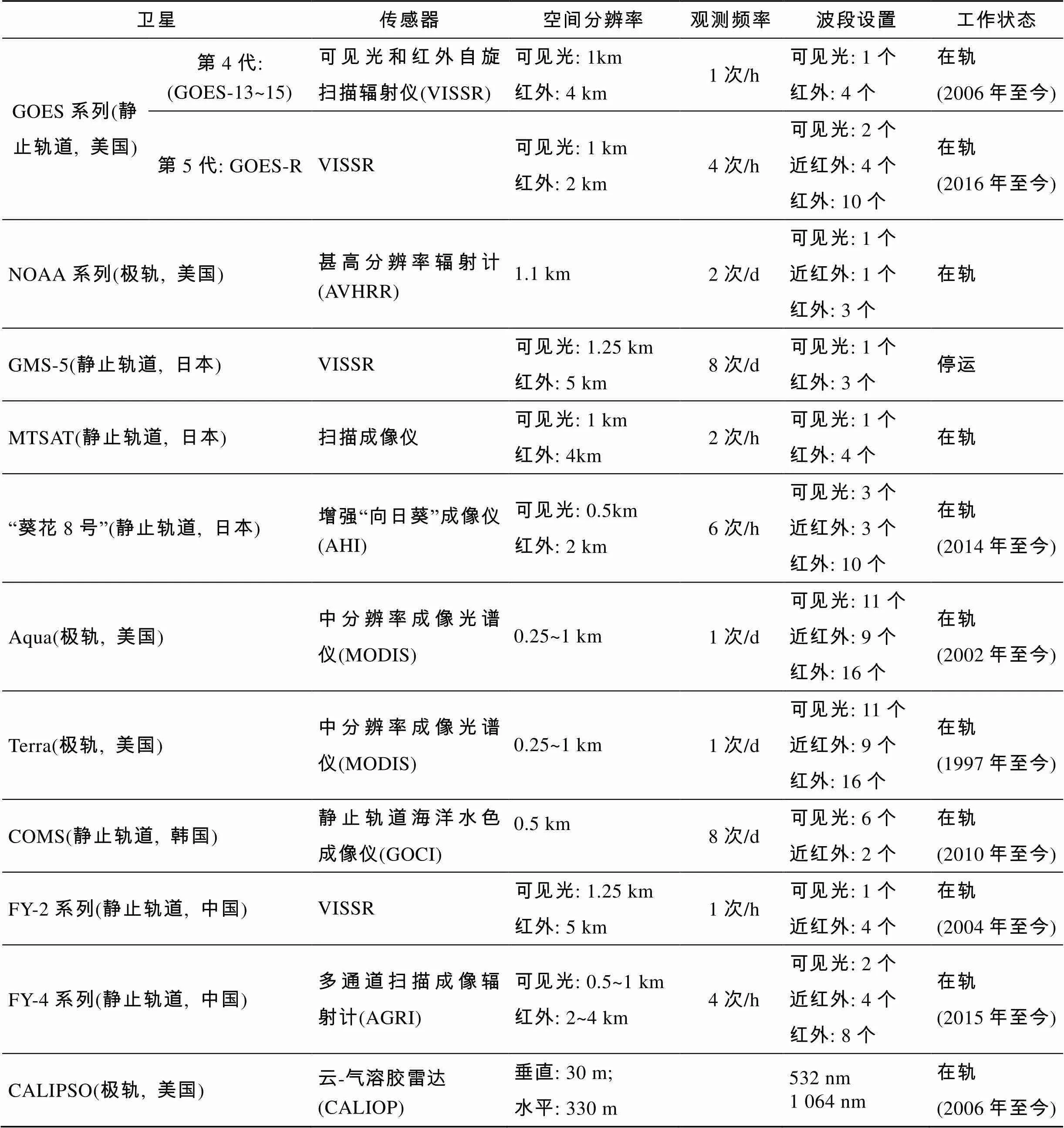
表1 海雾遥感探测中可用的卫星数据
2.2 海雾探测遥感研究进展
2.2.1 基于被动卫星遥感器的海雾识别探测
20世纪70年代开始, 国内外学者尝试利用云雾在辐射特性上的差异进行云雾检测研究[13-19], 阈值法是最常用的检测方法。1973年Hunt[20]发现3.7 μm通道的散射信号能够反映出小粒子云(如低云和雾)的特性。基于这一发现, Eyre等[21]提出了利用NOAA/ AVHRR通道3(3.7 μm中红外通道)和通道4(11 μm热红外通道)的亮温差阈值, 即双通道差值法, 来识别大雾。该方法提出后得到了广泛讨论和实验[22-30], 是目前夜间低层云雾监测的业务化方法。
由于中红外通道在白天还会受到反射辐射的影响, 因此双通道差值法并不适用于白天的海雾遥感探测。针对白天云雾的识别探测, 国内外研究者也开展了大量的相关研究, 阈值法仍然是最常用的方法。Anthis等[31]利用NOAA/AVHRR的3个红外通道数据和METEOSAT数据统计了白天大雾和夜间大雾的光谱特性, 并根据统计得到的阈值范围开展了大雾检测; 张春桂等[32-33]利用MODIS数据, 在分析海洋、中高云、低云和海雾等不同下垫面的可见光和红外辐射特征基础上, 确定海雾监测阈值, 建立了白天海雾遥感监测模型, 模型准确率可达80%以上; 周红妹等[34]基于云、雾、下垫面的可见光和红外光谱特征及辐射性质提出了准雾区自动提取方法; 蒋璐璐等[35]利用国产的FY-3A风云卫星的VIRR数据, 采用多波段阈值法对2010年中国沿海地区的海雾进行了检测; Yuan等[36]分析海雾/层云、晴空海表和云的光谱特性, 构建了基于GOCI的黄海海雾白天探测算法。
除上述辐射特征外, 纹理特征也是大雾检测的重要判据。Karlsson等[37]利用红外通道, 分析了不同云类型的图像纹理。李亚春等[38-39]利用气象卫星阐述了遥感检测雾的基本原理和雾的纹理特点; 张顺谦等[40]以地物光谱信息和图像纹理信息作为分类标识, 将分形理论和BP神经网络应用于夜间浓雾的遥感监测, 提高了夜间浓雾的监测精度。金宝刚等[41]利用NOAA/AVHRR-3数据, 结合白天大雾的纹理特性, 提出了识别白天大雾的BP神经网络方法。
在海雾的遥感探测中, 利用单一通道或特征的阈值很难实现海雾的识别, 需要综合运用多个通道或特征。刘希等[42]综合运用可见光反射率阈值法、3×3像元空间一致性检测法、红外亮温阈值法及双通道差值法, 建立了全天时海雾遥感探测算法; 邓玉娇等[43]采用多通道阈值判识法, 利用MODIS数据开展了南海白天海雾监测; 黄子革等[44]分析了太阳高度角正弦和日地距离对MODIS海雾探测阈值的影响, 以此得到了收敛的阈值; 何月等[45]基于MTSAT卫星观测数据, 采用分级判识太阳高度角阈值和归一化大雾指数的方法, 构建了陆地和海上遥感大雾监测模型; 衣立[5]和Zhang等[46]利用MODIS对低云和海雾进行区分, 提出了黄海海雾动态阈值遥感反演算法。
2.2.2 基于主动卫星遥感器的海雾探测
层云与海雾类似, 两者在光学特性和物理性质上没有本质的区别, 导致卫星上被动探测器接收到的海雾和层云信号相似, 难以将层云与海雾区分开。海雾和层云最主要的区别在于层云云底不与海面相接, 而海雾紧贴海面, 因此区分层云和海雾最直接也是最可靠的方法就是获取云/雾底高度。主动的激光雷达, 如CALIOP(Cloud-AerosolLidarwith Orthogonal Polarization, CALIPSO)和毫米波雷达CPR (Cloud Profiling Radar, CloudSat)等, 可穿透云层或者气溶胶, 能够获取大气的垂直剖面结构信息。尤其是CALIOP, 它的垂向分辨率达到30 m, 可准确区分海面、海雾、低云、中高云、气溶胶等。
许多研究者将CALIOP得到的云层信息与其他传感器的结果进行比对。总的来说, CALIOP判别有云的概率大于MODIS的判别结果, 原因是CALIOP对薄云更为敏感[6-7]。Badarinath等[47]将CALIOP数据应用于印度恒河平原的大雾研究, 证明了CALIOP数据用于雾研究的可行性。魏书晓[48]利用CALIOP后向散射系数数据检测海雾区域, 并基于CALIOP判定的海雾区域实现了MODIS海雾的初步识别。卢博[49]和Wu等[50]提出了结合CALIOP二级VFM产品和一级后向散射系数数据检测海雾的方法, 提取了大量的海雾、低云、中高云和晴空海表样本点, 应用于MODIS日间海雾检测研究中。
2.3 海雾特征量遥感反演进展
与海雾的遥感识别探测相比, 海雾的物理特性遥感反演研究相对滞后。所反演的特征量以能见度为主, 还包括光学厚度、有效粒子半径、液态水路径(云雾中垂直积分的液态水含量)、雾顶高度(海雾厚度)等[51-61]。总的来看, 目前有关海雾物理特性的遥感反演研究主要针对白天雾, 夜间雾属性反演的研究甚少。由于云、雾特征量的反演具有共性, 海雾特征量的反演往往借鉴云特征量的反演方法。
海雾特征量的遥感反演以被动传感器为主, 依据海雾的反射和发射辐射特性获取。1973年Hunt发现10.8 μm和3.9 μm通道的亮温差与云的光学厚度存在关系。Ellrod[62-63]基于Hunt的结论, 利用静止卫星GOES估算了雾的厚度和层云云底高度(小于300 m)。Stephens等[64]发现, 在波长小于0.7 μm的非吸收波长上, 雾的光谱反照率能够反演出雾的光学厚度和微物理性质。Platnick等[65]利用NOAA/AVHRR通道1(0.6 μm)和通道3(3.7 μm)反演了海上层云的光学厚度。Bendix[66]基于辐射传输理论, 利用AVHRR通道1的雾顶反射率数据, 反演了白天雾的能见度, 与地面能见度仪的偏差为56 m; 吴晓京等[67]应用MODIS数据定量反演了新疆北部大雾的能见度、垂直总水汽含量和有效粒子半径; 蒋璐璐等[35]利用FY-3A/ VIRR数据反演了白天雾的光学厚度、垂直厚度和能见度,证明了FY-3A监测雾的可行性。张伟康等[68]基于SBDART辐射传输模型和BP神经网络开展了夜间雾的检测, 同时反演了雾区能见度, 误差约为20%。
许多研究表明海雾特征量之间存在直接或间接的关系, 通过某一特征量可间接反演得到其他参量[69-70]。Minnis等[71]和Heidinger等[72]发现了光学厚度与层云厚度的关系, 并依据光学厚度反演得到了云的厚度[71-72]; Brenguier等[73]利用Brenguier[74]分析的凝结过程, 发现液态水路径与云层厚度的平方存在关系; Bendix[26]提出了液态水路径与光学厚度之间存在的函数关系; Greenwald和Christopher[75]基于雾层的液态水路径和光学厚度估算了雾的有效粒子半径。
主动的星载激光雷达数据也被用于反演云雾的物理特征量。Weisz等[76]和Holz等[77]利用CALIOP反演得到了云顶高度, 并将结果与MODIS的反演结果对比, 发现CALIOP得到的云顶高度更高, 高空云的差别最大。Yu等[78]基于CALIOP数据, 根据气溶胶粒径分布服从对数正太分布的特点, 利用神经网络等方法拟合获得了海雾粒径分布函数。
3 海雾遥感监测中存在的问题及解决思路
3.1 低云和大雾的高精度区分
低云和海雾之间能够相互转化, 低云下沉会成为海雾, 海雾抬升会成为低云。海雾是一种典型的自然灾害, 对海上交通运输和海上活动等有严重影响, 而低云主要影响飞机起降, 对海上船只航行的影响较小, 因此区分低云和大雾具有重要的实际意义。
由于低云和大雾在物理性质上没有本质的区别, 其光学特性极为相似, 利用被动遥感器实现低云和大雾的区分仍然是一个难题。从海雾识别遥感研究现状看, 在使用被动遥感器进行海雾检测时, 普遍存在海雾卫星遥感准确性不高的问题。并且在最为常用的阈值法, 中阈值的确定受太阳高度角、日地距离、海面粗糙度等多种因素的影响, 算法可移植性差, 自动化程度低, 至今没有相对成熟的业务化算法。主动的遥感器, 如CALIOP激光雷达等, 虽然能够获取30 m垂向分辨率的大气垂直剖面信息, 可以准确区分低云和大雾, 但目前的卫星激光雷达只能对星下点进行单点探测, 且重访周期较长(CALIOP为16 d), 无法实现对海雾高时间分辨率和大空间范围的连续探测。另外, 由于CALIOP的探测波长短, 经过云层时造成的衰减强, 仅能探测相对较薄的云层, 无法穿透相对较厚的云层, 因此无法探测厚云下方的海雾。
从目前来看, 低云和大雾的区分仍然要依靠两者之间辐射和纹理特征的差异, 而首先要解决的问题是如何准确获取海雾、低云样本点。由于海雾和低云在光学遥感影像上的表现极为相似, 肉眼难以判断, 依靠目视解译的样本选取方式显然保证不了样本点的准确性。主动的星载激光雷达虽然只能进行单点探测, 但可以获取大气的垂直剖面信息, 进而得到准确的海雾和低云位置。因此, 主、被动光学卫星数据结合是准确获取海雾、低云样本点的有效途径。
在探测方法上, 深度学习是机器学习研究中的一个新的领域, 通过多层人工神经网络, 从大量训练数据集中不断地归纳总结, 从而实现对新数据样本的智能识别和准确预测, 已在语音识别、图像识别等方面取得了突破性进展。星载激光雷达和被动光学卫星已在轨运行十余年, 利用所积累的卫星数据可以获取海量的海雾、低云样本, 能够满足深度学习对训练样本数据量的要求, 深度学习在图像识别领域的能力可能会为低云和大雾的区分提供新的思路。
3.2 海雾能见度高精度反演
能见度是衡量海雾等级大小的重要物理量, 因此, 能见度的遥感反演具有重要的实际应用价值。目前海雾能见度遥感反演的研究较少, 反演精度相对较低。一方面是遥感反演算法没有充分考虑海雾的机理, 算法中的近似假定条件增加了反演结果的不确定性。另一方面, 缺乏足量的现场观测数据用于云雾能见度遥感反演模型的验证, 现场观测数据的缺乏也是导致海雾机理研究不深入的重要原因。目前覆盖范围最广、最全面、观测数据量最大的海雾观测数据来自国际综合海洋-大气数据集(International Comprehensive Ocean-Atmosphere Data Set, ICOADS),它收集了1784年至今的来自多个国家的船舶、锚系浮标和漂浮浮标、沿海观测站以及海上平台设备的观测资料, 原始观测报告超过2千万次。但该数据集的观测主要集中在航线附近, 空间和时间上分布不均匀; 此外, 由于每次观测报告都是独立获取, 因观测方法、观测设备、观测条件和通讯条件不同, 资料具有一定的差异性, 尤其是能见度, 主要依靠人工观测, 不同观测资料之间的数值是否具有可比性本身就是一个值得探讨的问题。
如何增加与海雾相关物理量的观测是提高海雾能见度反演精度的关键。在由商船、交通船、渔船等组成的志愿船上安装气象、水文等自动观测设备, 在航行和作业过程中自动获取大气和海洋物理参数, 能够在很大程度上弥补海雾现场观测数据不足和观测资料可比性差的现状。
在海雾能见度遥感反演方法上, 目前的研究主要利用被动光学卫星数据, 缺点是被动的光学卫星数据无法穿透海雾, 只能通过雾顶信息间接反演能见度, 算法的理论基础和可移植性都较差; 激光雷达在大气和云物理特性(如气溶胶光学厚度、大气能见度、云光学厚度等)反演方面已有较为理想的应用效果, 地基/星载激光雷达与被动的光学卫星结合有潜力提高海雾能见度的反演精度。
4 结论
卫星数据已经被证明是目前海雾大范围、高时空分辨率监测的最有效手段。随着遥感技术的发展, 尤其是卫星激光雷达的出现, 海雾的探测精度有了极大的提升。国内外研究者利用被动和主动的卫星遥感数据, 结合海雾的辐射和纹理等特性, 开展了大量海雾识别探测和物理特征量反演研究。但总体来看, 基于卫星遥感的海雾监测技术还远不成熟, 仍然存在低云和海雾难以区分、海雾物理特征量反演精度低等问题。结合主动和被动卫星光学数据, 获取大量准确的海雾和低云样本, 发展基于深度学习的低云和海雾识别算法; 构建基于志愿船的海雾参数自动观测系统, 获取大量高精度的现场观测数据, 深入分析海雾形成和消散机理, 提高海雾物理特征量反演精度是今后海洋遥感探测的重要课题。
[1] 张苏平, 鲍献文. 近十年中国海雾研究进展[J]. 中国海洋大学学报, 2008, 38(3): 359-366.
Zhang Suping, Bao Xianwen. The main advances in sea fog research in China [J]. Periodical of Ocean University of China, 2008, 38(3): 359-366.
[2] Koračin D, Dorman C E, Lewis J M, et al. Marine fog: A review[J]. Atmospheric Research, 2014, 143: 142-175.
[3] 江海英, 张韧, 刘科峰. 青岛海雾的自适应神经模糊推理系统建模[J]. 海洋科学, 2005, 29(2): 26-31.
Jiang Haiying, Zhang Ren, Liu Kefeng. Anfis modeling on Qingdao sea fog[J]. Marine Sciences, 2005, 29(2): 26-31.
[4] Zhang S, Ren Z, Liu J. Variations in the lower level of the PBL associated with the Yellow Sea fog-New observations by L-Band radar[J]. Journal of Ocean University of China (Oceanic and Coastal Sea Research), 2008. 7: 353-361.
[5] 衣立. 黄海海雾/层云的空间分布及云底高度遥感方法研究[D]. 青岛: 中国海洋大学, 2015.
Yi Li. Spatio-temporal detection of sea fog/stratus and cloud base height over Yellow Sea with satellite data- a feasibility study[D]. Qingdao: Ocean University of China, 2015.
[6] Cho H M, Yang P, Kattawar G W, et al. Depolarization ratio and attenuated backscatter for nine cloud types: analyses based on collocated CALIPSO lidar and MODIS measurements.[J]. Optics Express, 2008, 16(6): 3931-3948.
[7] 吴东, 贾佳. CALIPSO星载激光在全球海洋上空的穿透性统计[J]. 大气与环境光学学报, 2011, 6(4): 252- 259.
Wu Dong, Jia Jia. GLOBAL penetrability statistics of caliopso over ocean laser samples[J]. Journal of Atmospheric and Environmental Optics, 2011, 6(4): 252- 259.
[8] 衣立. 基于MODIS卫星资料海雾反演及适用性分析[D]. 青岛: 中国海洋大学, 2011.
Yi Li. Sea fog retrieval and the applicability of retrieval basing on MODIS data[D]. Qingdao: Ocean University of China, 2011.
[9] Ling X. Retrieval of fog microphysical parameters from NOAA AVHRR data[D]. Reno: University of Nevada, 1995.
[10] 刘健, 许健民, 方宗义.利用NOAA 卫星的AVHRR 资料试分析云和雾顶部粒子的尺度特征[J]. 应用气象学报, 1999, 10(1): 28-33.
Liu Jian, Xu Jianmin, Fang Zongyi. Analysis of the particle sizes at top of cloud and fog with NOAA/AVHRR data[J]. Quarterly Journal of Applied Meteorology, 1999, 10(1): 28-33.
[11] Fu G, Guo J, Xie S, et al. Analysis and high-resolution modeling of a dense sea fog event over the Yellow Sea[J]. Atmospheric Research, 2006, 81: 293-303.
[12] Gao S, Lin H, Shen B, et al. A heavy sea fog event over the Yellow Sea in March 2005: analysis and numerical modeling[J]. Advances in Atmospheric Sciences, 2007, 24: 65-81.
[13] Allam R. The detection of fog from satellites [C]// Meteorological Office College. Satellite and Radar Imagery Interpretation, preprints for a Workshop on Satellite and Radar Imagery Interpretation. Darmstadt Eberstadt, West Germany: EUMETSAT, 1987: 495-505.
[14] Lee T E, Tuik F J, Richardson K. Stratus and fog products suing GOES-8-9 3.9 μm data[J]. Weather and Forecasting, 1997, 12: 664-677.
[15] 马慧云, 李德仁, 刘良明, 等. 基于MODIS卫星数据的平流检测研究[J]. 武汉大学学报(信息科学版), 2005, 20(2): 143-145.
Ma Huiyun, Li Deren, Liu Liangming, et al. Fog detection based on eos MODIS data [J]. Geomatics and Information Science of Wuhan University, 2005, 20(2): 143-145.
[16] 马慧云, 李德仁, 刘良明, 等. 基于AVHRR、MODIS和MVRIS数据的辐射雾变化检测与分析[J]. 武汉大学学报(信息科学版), 2007, 32(4): 297-300.
Ma Huiyun, Li Deren, Liu Liangming, et al. Fog dynamic change detection based on AVHRR, MODIS AND MVIRS DATA[J]. Geomatics and Information Science of Wuhan University, 2007, 32(4): 297-300.
[17] Cermak, J, Bendix J. A novel approach to fog /low stratus detection using Meteosat 8 data[J]. Atmospheric Research, 2008, 87: 279-292.
[18] Lee J R, Chung C Y, Ou M L. Fog detection using geostationary satellite data: temporally continuous algorithm[J]. Asia-Pacific Journal of the Atmospheric Sciences. 2011, 47: 113-122.
[19] 吴晓京, 李三妹, 廖蜜, 等. 基于20年卫星遥感资料的黄海、渤海海雾分布季节特征分析[J]. 海洋学报, 2015, 37(1): 63-72.
Wu Xiaojing, Li Sanmei, Liao Mi, et al. Analyses of seasonal feature of sea fog over the Yellow sea and Bohai sea based on the recent 20 years of satellite remote sensing data[J]. Acta Oceanologica Sinica, 2015, 37(1): 63-72.
[20] Hunt G E. Radiative properties of terrestrial clouds at visible and infrared thermal window wavelengths[J]. Quarterly Journal of the Royal Meteorological Society, 1973, 99: 346-369.
[21] Eyre J R, Brownscombe J L, Allam R J. Detection of fog at night using Advanced Very High Resolution Radiometer(AVHRR) imagery[J]. Meteorology Magazine, 1984, 113: 266-271.
[22] Turner J, Allama R J, Maine D R. A case study of the detection of fog at night using channels 3 and 4 on the Advanced Very High Resolution Radiometer (AVHRR)[J]. Meteorological Magazine, 1986, 115: 285-297.
[23] Bendix J, Bachmann M. A method for detection of fog using AVHRR imagery of NOAA satellites suitable for operational purposes (in German)[J]. Meteor Rundsch, 1991, 43: 169-178.
[24] Bachmann M, Bendix J. An improved algorithm for NOAA-AVHRR image referencing[J]. International Journal of Remote Sensing, 1992, 13(16): 3205-3215.
[25] Putsay M, Kerenyi J, Szenyan I, et al. Nighttime fog and low cloud detection in NOAA-16 AVHRR images and validation with ground observed SYNOP data and radar measurements [C]// Proceedings of the 2001 EUMETSAT Meteorological Satellite Conference, EUM P33, 365-373, EUMETSAT, Antalya, Turkey.
[26] Bendix J. A satellite-based climatology of fog and low- level sratus in Germany and adjacent areas[J]. Atmospheric Research, 2002, 64: 3-18.
[27] Ahn M H, Sohn E H, Hwang B J. A new algorithm for sea fog/stratus detection using GMS-5 IR data[J]. Advances in Atmospheric Sciences, 2003, 20: 899-913.
[28] Underwood S J, Ellrod G P, Kuhnert A L. A muliplecase analysis of nocturnal radiation-fog development in the Central Valley of California utilizing the GOES nighttime fog product [J]. Journal of Applied Meteorology, 2004, 43: 297-311.
[29] Bendix J, Thies B, Cermak J. Fog detection with TERRA- MODIS and MSG-SEVIRI [C]// European Organisation for the exploitation of meteorological satellites. Processing of the 2003 Metheorological Satellite Data Users’ Conference. Weimar: European Organisation for the exploitation of meteorological satellites, 2004: 429-435.
[30] Gultepe I, Milbrant J A. Microphysical observations and mesoscale model simulation of a warm fog case during FRAM project[J]. Pure Applied Geophysics, 2007, 164: 1161-1178.
[31] Anthis A I, Crackell A P. Use of satellite images for fog detection (AVHRR) and forecast of fog dissipation (METEOSAT) over lowland Thessalia, Hellas[J]. International Journal of Remote Sensing, 1999, 20: 1107- 1124.
[32] 张春桂, 蔡义勇, 张加春. MODIS遥感数据在我国台湾海峡海雾监测中的应用[J]. 应用气象学报, 2009, 20(1): 8-16.
Zhang Chungui, Cai Yiyong, Zhang Jiachun. The application of monitoring sea fog in Taiwan Strait using MODIS remote sening data[J]. Journal of Applied Meteorological Science, 2009, 20(1): 8-16.
[33] 张春桂, 何金德, 马治国. 福建沿海海雾的卫星遥感监测[J].中国农业气象, 2013, 34(3): 366-373.
Zhang Chungui, He Dejin, Ma Zhiguo. Remote sensing monitoring of sea fog in Fujian coastal region[J]. Chinese Journal of Agrometeorology, 2013, 34(3): 366-373.
[34] 周红妹, 汤绪, 葛伟强, 等. 城市和沿海大雾遥感自动检测和云、雾分离技术研究[J]. 高原气象, 2011, 30(3): 675-682.
Zhou Hongmei, Tang Xu, Ge Weiqing, et al. Automatic detection of heavy fog and cloud-fog separation technology in city and coastal area of eastern china based on meteorological satellite remote sensing image [J]. Plateau Meteorology, 2011, 30(3): 675-682.
[35] 蒋璐璐, 魏鸣. FY-3A卫星资料在雾监测中的应用研究[J]. 遥感技术与应用, 2011, 26(4): 489-495.
Jiang Lulu, Wei Ming. Application of fog monitoring with FY-3A data[J]. Remote sensing Technology and Application, 2011, 26(4): 489-495.
[36] Yuan Y B, Qiu Z F, Sun D Y, et al. Daytime sea fog retrieval based on GOCI data: a case study over the Yellow Sea[J]. Optics Express, 2016, 24(2): 787-801.
[37] Karlsson K G. Development of an operational cloud classication model[J]. International Journal of Remote Sensing, 1989, 10: 687-693.
[38] 李亚春, 孙涵, 徐萌. 气象卫星在雾的遥感监测中的应用与存在的问题[J]. 遥感技术与应用, 2000, 15(4): 223-227.
Li Yachun, Sun Han, Xu Meng. The present situation and problems on detecting fog by remote sensing with metrological satellite [J]. Remote Sensing Technology and Application, 2000, 15(4): 223-227.
[39] 李亚春, 孙涵, 李湘阁, 等. 用GMS-5气象卫星资料遥感监测白天雾的研究[J]. 南京气象学院学报, 2001, 24(3): 343-349.
Li Yachun, Sun Han, Li Xiangge, et al. Study on detection of daytime fog using GMS-5 weather satellite data[J]. Journal of Nanjing Institute of Meteorology, 2001, 24(3): 343-349.
[40] 张顺谦, 杨秀蓉. 基于神经网络和分形纹理的夜间浓雾遥感监测技术[J]. 应用气象学报, 2005, 16(6): 804- 810.
Zhang Shunqian, Yang Xiurong. Remote sensing monitoring technology of thick fog at night based on neural networks and fractal grain[J]. Journal of Applied Meteorological Science, 2005, 16(6): 804-810.
[41] 金宝刚, 张韧, 王晓蕾, 等. 基于BP神经网络与纹理分析优化的雾检测[J]. 解放军理工大学学报(自然科学版), 2009, 10(2): 195-199.
Jin Baogang, Zhang Ren, Wang Xiaolei, et al. Optimized fog detection and classification technique BASED on BP artificial neural network and texture analysis[J]. Journal of Pla University of Science and Technology (Natural Science Edition), 2009, 10(2): 195-199.
[42] 刘希, 胡秀清. 基于MTSAT卫星的我国东部沿海雾区的自动识别[J]. 台湾海峡. 2008, 27(1): 112-117.
LIU Xiu, HU Xiuqing. Sea fog automatic detection over the East China Sea using MTSAT data [J]. Journal of Oceanography in Taiwan Strait, 2008, 27(1): 112-117.
[43] 邓玉娇, 王捷纯, 曹静. 基于MODIS 遥感资料监测南海白天雾[J]. 热带气象学报, 2013, 29(6): 1046- 1050. Deng Yujiao, Wang Jiechun, Cao Jing. Detection of day time fog in South China Sea using MODIS data[J]. Journal of Tropical Meteorology, 2013, 29(6): 1046- 1050.
[44] 黄子革, 潘长明, 王贵钢, 等. MODIS卫星海雾检测技术研究[J]. 海洋测绘, 2010, 30(2): 70-73.
Huang Zige, Pan Changming, Wang Guigang, et al. Study on the technique of sea fog detection using MODIS data[J]. Hydrographic Surveying and Charting, 2010, 30(2): 70- 73.
[45] 何月, 张小伟, 蔡菊珍, 等.基于MTSAT卫星遥感监测的浙江省及周边海区大雾分布特征[J].气象学报, 2015, 73(1): 200-210.
He Yue, Zhang Xiaowei, Cai Juzhen, et al. distribution characteristics of the fog derived from the MTSAT satellite data in Zhejiang province and its adjacent sea area[J]. Acta Meteorologica Sinica, 2015, 73(1): 200-210.
[46] Zhang S, Yi L. A comprehensive dynamic threshold algorithm for daytime sea fog retrieval over the Chinese adjacent seas[J]. Pure and Applied Geophysics, 2013, 170(11): 1931-1944.
[47] Badarinath K V S, Kharol S K, Sharma A R, et al. Fog over Indo-Gangetic Plains-a study using multisatellite data and ground observations[J]. IEEE Journal of Selected Topics in Applied Earth Observations & Remote Sensing, 2009, 2(3): 185-195.
[48] 魏书晓. 星载激光雷达在基于MODIS海雾检测中的应用[D]. 青岛: 中国海洋大学, 2013.
Wei Shuxiao. Application of caliop in MODIS-Based sea fog detection[D]. Qingdao: Ocean University of China, 2013.
[49] 卢博. CALIOP海雾检测及其在MODIS日间海雾遥感中的应用[D]. 青岛: 中国海洋大学, 2015.
Lu Bo. CALIOP sea fog detection and its application to daytime MODIS remote sensing of sea fog[D]. Qingdao: Ocean University of China, 2015.
[50] Wu D, Lu B, Zhang T C, et al. A method of detecting sea fogs using CALIOP data and its application to improve MODIS-based sea fog detection[J]. Journal of Quantitative Spectroscopy and Radiative Transfer, 2015, 153: 88-94.
[51] Stephens G L. Radiation profiles in extended water clouds: I Theory[J]. Journal of Atmospheric Science, 1978, 35: 2111-2123.
[52] Stephens G L. Radiation profiles in extended water clouds: II Parameterization Schemes[J]. Journal of Atmospheric Science, 1978, 35: 2123-2132.
[53] Stephens G L. A shortwave parameterization revised to improve cloud absorption[J]. Journal of Atmospheric Science, 1984, 41: 687-690.
[54] Bendix J. Determination of fog horizontal visibility by means of NOAA-AVHRR[C]// IGARSS. International Geoscience & Remote Sensing Symposium. Piscataway: IEEE, 1995, 3: 1847-1849.
[55] 王鑫. 黄海海雾形成的气候特征及能见度分析[D]. 青岛: 中国海洋大学, 2004.
Wang Xin. Climatic characters of sea fog formation of the Huanghai and analysis of visibility[D]. Qingdao: Ocean University of China, 2004.
[56] 傅刚, 王菁茜, 张美根, 等. 一次黄海海雾事件的观测与数值模拟研究—以 2004 年 4月 11 日为例[J]. 中国海洋大学学报, 2004, 34(5): 720-726.
Fu Gang, Wang Jingqian, Zhang Meigen, et al. An observational and numerical study of a SEA FOG EVENT over the yellow sea on 11 april, 2004[J]. Periodical of Ocean University of China, 2004, 34(5): 720-726.
[57] 傅刚, 徐杰, 张树钦. 数值模拟和卫星反演大气能见度对比分析[J]. 中国海洋大学学报, 2011, 41(4): 1-10.
Fu Gang, Xu Jie, Zhang Shuqin. Comparison of modeling atmospheric visibility with visible satellite imagery[J]. Periodical of Ocean University of China, 2011, 41(4): 1-10.
[58] 钱峻屏, 黄菲, 崔祖强, 等. 基于 MODIS 数据的海上气象能见度遥感光谱分析与统计反演[J]. 海洋科学进展, 2004, 22(增刊): 58-64.
Qian Junping, Huang Fei, Cui Zuqiang, et al. SpectraL analysis and statistical retrieval of marine meteorological visibility using MODIS data[J]. Advances in Marine Science, 2004, 22(z1): 58-64.
[59] 钱峻屏, 黄菲, 王国复, 等. 基于 MODIS 资料反演海上能见度的经验模型[J]. 中国海洋大学学报, 2006, 36(3): 355-360.
Qian Junping, Huang Fei, Wang Guofu, et al. Empirical models for retrieval of atmospheric horizontal visibility over the sea based on MODIS data[J]. Periodical of Ocean University of China, 2006, 36(3): 355-360.
[60] 张纪伟, 张苏平, 吴晓京, 等. 基于 MODIS 的黄海海雾研究——海雾特征量反演[J]. 中国海洋大学学报, 2009, 39(增刊): 311-318.
Zhang Jiwei, Zhang Suping, Wu Xiaojing, et al. The research on Yellow sea sea fog based on MODIS data: Sea fog properties retrieval and spatial-temporal distribution [J]. Periodical of Ocean University of China, 2009, 39(s1): 311-318.
[61] Rausch J, Heidinger A, Bennartz R. Regional assessment of microphysical properties of marine boundary layer cloud using the PATMOS-x dataset[J]. Journal of Geophysical Research Atmospheres, 2010, 115(D23): 6696-6705.
[62] Ellrod G P. Advances in the detection and analysis of fog at night using GOES multispectral infrared imagery[J]. Weather and Forecasting, 1995, 10: 606-619.
[63] Ellrod G P. Estimation of low cloud base heights at night from satellite infrared and surface temperature data[J]. National Weather Digest, 2002, 26: 39-44.
[64] Stephens G L, Smith E A. A short wave parameterization revised to improve cloud absorption[J]. Journal of Atmospheric Science, 1984, 41: 687-690.
[65] Platnick S, Valero S F P J. A validation study of a satellite cloud retrieval duringASTEX[J]. Journal of Atmospheric Science, 1995, 52: 2985-3001.
[66] Bendix J. A case study on the determination of fog optical depth and liquid waterpath using AVHRR data and relations to fog liquid water content and horizontal visibility[J]. Remote Sensing, 1995, 16(3): 515-530.
[67] 吴晓京. 应用MODIS数据对新疆北部大雾地面能见度和微物理参数的反演[J]. 遥感学报, 2005, 9(6): 688- 696.
Wu Xiaojing. Utilizing MODIS data to retrieve the visibility and microphysical properties of fog happens in the northwest China[J]. Journal of Remote Sensing, 2005, 9(6): 688-696.
[68] 张伟康. 基于MODIS卫星数据的夜间辐射雾检测和属性反演[D]. 长沙: 中南大学, 2013.
Zhang Weikang. Nighttime radiation fog detection and properties retrieval based on EOS/MODIS data[D]. Changsha: Central South University, 2013.
[69] Eldridge R G. The Relationship between visibility and liquid water content in Fog[J]. Journal of the atmospheric sciences, 1971, 28: 1173-1186.
[70] Ippolito L J. Propagation Effects Handbook for Satellite System Design: A summary of propogation impairments on 10 to 100 GHz[M]. Baltimore, Maryland: NAS, 1989.
[71] Minnis P. Stratocumulus cloud propreties derived from simultaneous satellite and island-based instrumentation during FIRE[J]. Journal of Applied Mteorology, 1992, 31: 317-339.
[72] Heidinger A K, SETPHENS G L. Molecular Line absorption in a scattering atmosphere. Part Ⅱ: application to remote sensing in the O2 A band[J]. Journal of the Atmospheric Sciences, 2000, 57: 1615-1634.
[73] Brenguier J L, PawlowskA H, Schtiller L, et al. Radiative properties of boundary layer clouds: Droplet effective radius versus number concentration[J]. Journal of the atmospheric sciences, 2000, 57(6): 803-821.
[74] Brenguier J L. Parameterization of the condensation process: A theoretical approach[J]. Journal of the atmospheric sciences, 1991, 48(2): 264-282.
[75] Greenwald T J, Christopher S A, Chou J. Cloud liquid water path comparisons from passive microwave and solar reflectance satellite measurements: Assessment of sub-field-of-view cloud effects in microwave retrievals[J]. Journal of Geophysical Research, 1997, 102(D16): 19585- 19596.
[76] Weisz E, Li J, Menzel W P, et al. Comparison of AIRS, MODIS. CloudSat and CALIPSO cloud top height retrievals[J]. Geophysical Research Letters, 2007, 34(17): 251-270.
[77] Holz R E, Ackerman S A, Nagle F W, et al. Global moderate resolution imaging spectroradiometer (MODIS) cloud detection and height evaluation using CALIOP[J]. Journal of Geophysical Research: Atmospheres, 2008, 113(8): D00A19.
[78] Yu H, Chin M, Winker D M, et al. Global view of aerosolvertical distributions from CALIPSO lidar measurements and GOCART simulations: Regional and seasonal variations[J]. Journal of Geophysical Research, 2010, 115(D4): 1307-1314.
Review of sea fog detection from satellite remote sensing data
XIAO Yan-fang1, ZHANG Jie1, CUI Ting-wei1, QIN Ping2
(1. The First Institute of Oceanography. SOA, Qingdao 266061, China; 2.College of Information Science & Engineering, Ocean University of China, Qingdao 266100, China)
Sea fog can produce low visibility and create a great threat to maritime traffic and offshore operations. In addition, satellite remote sensing is a very important technical means for sea fog monitoring. This report begins with presenting the principle of remote sensing and monitoring of sea fog. The radiative characteristics and texture features of sea fog were first introduced. Then, this research reviews the main achievements in sea fog monitoring by remote sensing during the past decade, including the researches of sea fog detection and sea fog physical parameters inversion. Lastly, several problems in sea fog remote sensing monitoring are discussed.
E-mail: xiaoyanfang@fio.org.cn
sea fog; stratus clouds; summary; remote sensing
(本文编辑: 李晓燕)
[National Key R & D Program of China under contract No. 2016YFC1402703]
May 23, 2017
肖艳芳(1985-), 女, 汉族, 山东诸城人, 助理研究员, 博士, 主要从事海洋光学遥感方面研究, 电话: 0532-88967269,
P407
A
1000-3096(2017)12-0146-09
10.11759/hykx20170523001
2017-05-23;
2017-08-11
国家重点研发计划(2016YFC1402703)