Dynamic influence of Holocene characteristics on vadose water in typical region of central North China Plain
2016-12-11ZHANGWeiSHIJianshengXUJianmingLIUJichaoDONGQiuyaoFANShuxian
ZHANG Wei, SHI Jian-sheng, XU Jian-ming, LIU Ji-chao, DONG Qiu-yao, FAN Shu-xian
1 Institute of Hydrogeology and Environmental Geology, Chinese Academy of Geological Sciences, Shijiazhuang 050061, China.
2 School of Energy and Environmental Engineering, Hebei University of Technology, Tianjin 3000401, China.
Abstract: In the typical region of central North China Plain, vadose sediments are Holocene sediment strata. With samples from field drillings, the study analyzes the sedimentary characteristics of vadose zone. The study takes the content of silty sand as the basis for sedimentary environment analysis, and the content of clay and sand as the sensitive indicator for sedimentary characteristics. Combining palynology analysis, the study divides vadose zone from top to bottom into diluvia oxbow lacustrine sediments, lacustrine sediments, lacustrine and swamp sediments, weak palaeohydrodynamic lacustrine sediments and alluvial sediments.Based on the sedimentary characteristics of Holocene strata, it analyzes the changes across depth of vadose zone water potential and matrix potential, obtaining the influence of vadose zone sedimentary characteristics on the migration of water in typical region of central North China Plain.
Keywords: Typical region of North China Plain; Vadose zone; Sedimentary characteristics;Vadose zone water potential
Introduction
Groundwater exploitation in the North China Plain since the 1970s has caused large areas of groundwater funnels (ZHANG Zhao-ji et al. 2009),exhaustion of groundwater resources and deterioration of hydro-geological environment (LIU Chang-ming et al. 2001; Alley W M et al. 2002;ZHENG C et al. 2010). The exhaustion of groundwater resources severely endangers the industrial and agricultural development and water safety of the region (LI Guo-he et al. 2007).
As groundwater level drops, vadose zone thickens. Vadose zone, as Holocene sedimentary strata, can absorb, maintain and transport water. It plays an important connecting role for near-surface ecosystem and shallow groundwater.
The typical region of central North China Plain is in Hengshui region in the Hebei Plain. This region is a transitional zone from the North China piedmont plain to coastal plain. In the central North China Plain, groundwater is mainly recharged by piedmont lateral water flow, and secondly by atmospheric and surface water infiltration (Fig. 1a).But with the formation of piedmont groundwater funnels, lateral recharge for groundwater in central plain, especially shallow groundwater, has become insufficient. Therefore, atmospheric precipitation and surface water infiltration, in a sense, has taken on a crucial role for groundwater recharge (Fig. 1b)(SHI Jian-sheng et al. 2014).
1 Basic conditions of typical experiment region
1.1 Basic conditions of region and experiment field
The typical experiment region of the central North China Plain is located at the front of the Hutuo River ancient alluvial fan, where the Hutuo River and the Fuyang River sediments overlap. It is alluvial-diluvial-lacustrine plain. The climate is humid to semi-humid. Shallow groundwater is 8.5-9.2 m deep, and has high mineralization degree and low shallow water exploitation intensity (GAO Tai-zhong et al. 2002). Shallow groundwater in the region is mainly recharged by atmospheric water and surface runoff infiltration. Shenzhou experiment base which is 25 km north of Shenzhou, is in the central North China Plain, in Hujiachi Town,Shenzhou, Hengshui City, Hebei Province. The coordinates are N 37°54′23″, E 115°40′44″ (Fig. 2).

Fig. 1 Groundwater circulation in the North China Plain (a. 1960, b. 2014)
1.2 Landform and strata conditions of experiment base
The experiment area is in the alluvial low plain formed by the ancient Yellow River and the Haihe River in the central-eastern North China Plain. The land is low and flat, with a small slope. In the vadose zone are Holocene sediments, mostly alluvial-lacustrine, with depressions between rivers and oxbow lacustrine sediments (Fig. 3).

Fig. 2 Location of typical experiment base in central North China Plain

Fig. 3 Partial sections of vadose zone in central typical region
The vadose zone is less than 9 m thick. The lithology is mainly silty sand and clay (GAO Ye-xin et al. 2014), with some muddy clay and silty clay (Table 1). According to actual measurement data (Table 2), the infiltration coefficient difference of different strata can reach 103orders of magnitude. The maximum value of Kr/Kz is 4.5.

Table 1 Core HSK-1content variation of vadose zone sedimentation components

Table 2 Core HSK-6 strata lithology and relevant parameters
2 Experiment methods
The experiment is done through the multifunctional experiment observation well in the experiment base in Shenzhou, Hengshui City(Fig. 4). The well has a round shaft, rolled up spirally and welded from 10 mm-thick steel plate.On the wall of observation well, soil water potential sensor and soil water sampler are installed. 1.5 m from the vertical well is a neuron probe to monitor the water content of soil.
To facilitate the analysis of the influence of Holocene sedimentary characteristics on the migration of vadose water, neuron probe, tension meter and soil solution sampler are installed in the observation well. In and near the experiment field,drill sampling is carried out, to obtain rock cores at certain depths for particle, pore ratio and water content analysis.

Fig. 4 Multifunctional experiment observation well in central typical region
3 Experiment results and discussion
3.1 Holocene sedimentary characteristics
The sedimentary characteristics in the typical region of the central North China Plain mainly reflect the hydrodynamic sedimentary characteristics of the midstream ancient rivers. The content of clay and sand reflect the dynamic environment of sedimentation. The high sand and rough silty sand content shows that the hydrodynamic conditions are strong. The clay content in sediment strata to a certain extent reveals the sedimentary characteristics more effectively (Brunskill G J et al.2001; ZHANG Jun-hong, 2009; CHENG Baochong, 1993).
Based on the analysis of lithology of the wall of experiment well and the drills, the study analyzes the Holocene sedimentary characteristics in the typical region of the central North China Plain with the distribution of clay, silty sand and sand content across depths in core HSK-1 (Fig. 5),and finds that the lithology is mainly silty sand(with a content of 47.8%-83.6%), and that clay and sand content is the sensitive indicator for sedimentation dynamic. The particle standard deviation in the sediment strata is greater than 1,indicating poor sedimentary sorting features and that the Holocene landform in the central region is subject to strong river dynamic disturbance (Fig. 6).In consideration of the changes of clay in the sediment strata and based on the analysis of the percentage of sand of various levels (Fig. 8) and silty sand (Fig. 9), the Holocene vadose zone lithology characteristics can be divided into 6 sections as shown in Fig. 7.

Fig. 5 Core HSK-1clay, silty sand and sand content

Fig. 6 Core HSK-1 particle parameter
In section I, the rocks are light yellow, and tight at the bottom. The particle analysis indicates that as depth increases clay and silty sand content reduces and sand content rises (Fig. 5). Clay content is 16.7%, and silty sand average content 77.24%, of which the content of silty sand (26.24% on average)and rough silty sand (26.55% on average) are relatively high. The maximum sand content is 17.6%, mostly very fine sand (Fig. 8, Fig. 9).Besides, rough silty sand and sand content ratio rises as the depth increases. The average particle diameter is 27.6 um. The sorting feature is relatively poor (standard difference is 1-1.36), and the deviation is between 0.8-1.4 (Fig. 6). Strata deposit is mainly fluvial-alluvial, from the ancient river ways at mid-to-downstream. The hydrodynamic intensity is stable, resulting in relatively high silty sand content and reducing clay content.
In Section II, the lithology is brown and brownish yellow. Clay content rises as depth increases (22.48% on average). The content of silty sand sediments with particle size under 15.6 um also rises as depth increases, in which silty sand,rough silty sand and sand content reduces as depth increases (Fig. 8 and Fig. 9). In general, the lithology in this section has horizontal stratification;clay exists in tight blocks; the sorting feature is poor(standard difference is 1.4-1.6); and deviation is below 0 (Fig. 6). The ancient climate is sparse forest grassland (Fig. 10). The strata mainly consist of fine-grain sediments. The hydrodynamic environment is weak. They are lacustrine sediments. The thin layer in the middle is silty loam lens body,likely caused by dry ancient climate.

Fig. 7 Holocene to end of upper Pleistocene sedimentary characteristics in the typical region of central North China Plain

Fig. 8 Core HSK-1percentages of clay, silty sand and silty sand of various levels at different depths

Fig. 9 HSK-1 percentages of clay, sand and sand of various levels at different depths
In Section III, silty sand becomes stable(75.8% on average). The content of clay, very fine silty sand and fine silty sand shows a decreasing trend in this section, while the content of medium silty sand and rough silty sand shows an increasing trend (Fig. 8). The content of sensitive deposit sand tends to rise as depth increases (Fig. 9). The sedimentary characteristics are fluvial-alluvial sediments; the ancient sedimentary dynamic environment is strong; the ancient plantation landscape is mixed broad-leaved forest (Fig. 10);and the ancient climate is warm and rainy.
After dinner he built a fire, venturing out into the weather for wood he had piled against the garage the previous autumn. The air was bright and cold against his face, and the snow in the driveway was already halfway7 to his knees. He gathered logs, shaking off their soft white caps and carrying them inside. The kindling8 in the iron grate caught fire immediately, and he sat for a time on the hearth9, cross-legged, adding logs and watching the flames leap, blue-edged and hypnotic. Outside, snow continued to fall quietly through the darkness, as bright and thick as static in the cones10 of light cast by the streetlights. By the time he rose and looked out the window, their car had become a soft white hill on the edge of the street. Already his footprints in the driveway had filled and disappeared.
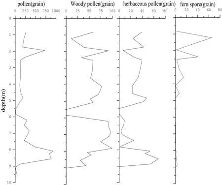
Fig. 10 Core HSK-1 pollen and spore content section
In Section IV, silty sand content is medium(51.33% on average), in which the content of very fine silty sand and fine silty sand is high and tends to drop as depth increases (Fig. 8). The deviation approximates 0; average particle diameter is 11 um,and the sorting feature is poor (Fig. 6). The organic substance content in the lower muddy strata is high(Fig. 7). The content of sensitive deposit clay stabilizes as depth increases (47.44 on average).The strata have horizontal stratification. Sand content reduces as depth increases (Fig. 9). The ancient plantation landscapes needle-leaved forest.The ancient climate is warm and humid (Fig. 10).The ancient sedimentary dynamic environment is weak. The sedimentary strata are lacustrine and swamp sediments, mixed with external deposits carried by rivers.
In Section V, silty sand content is on average 67.9%, in which the content of rough silty sand tends to drop as depth increases, and the content of very fine silty sand, fine silty sand and clay (21.1%on average) rises as depth increases (Fig. 8). The sorting feature is poor (Fig. 6). The sediment particle sizes are uneven. And the sedimentary characteristics are lacustrine sediments.
In Section VI, silty sand content is stable(67.2% on average); the content of sensitive indicator clay is stable (30.6% on average); the sand content rises as depth increases (maximum is 9.2%); the content of medium and rough sand also rises as depth increases; and the percentages of very fine silty sand and silty sand reduces as depth increases (Fig. 8, Fig. 9). According to the lithological features, strata in this section are diluvial oxbow lake sedimentary strata-Holocene initial sedimentary environment.
The lower strata of Section VI (Section VII)consist mainly of silty sand. Clay content drops(8%), and sand content increases. This is end of late Pleistocene fluvial-alluvial sedimentary strata.
3.2 Influence of sedimentary characteristics of vadose zone on soil water
The distribution of water in vadose zone soil changes across time and space. Such change can be depicted by scaling function (LI Yuan-shou et al.2008). It also demonstrates spatial and temporal heterogeneity due to lithological features, plantation, climate and landform, but the spatial distribution of soil moisture has certain similarities(Vachaud G et al. 1984).
As the vadose zone strata in the experiment typical region are Holocene strata, the influence of sedimentary characteristics on the movement and migration of water in vadose zone can be analyzed from the perspective of sedimentary structure.Evaluation of the change of soil water across depth based on soil particle size is not only convenient for application, but has certain physical significance (LV Dian-qing, 2003). The clay content in the sediments can reflect the change of soil structure, which affects the migration of water in vadose zone (Allbrook R F, 1993; Bhaskara Rao K et al. 1978).

Fig. 11 Water potential curve in typical experiment region in central North China Plain
The soil water potential curve across depth in the experiment well in typical experiment region indicates that 86 cm deep (Section I), 290 cm deep(in Section II) and 540 cm (in Section IV) are stability turning points of soil water potential (Fig. 11).
In typical experiment region in the central North China Plain, fluvial-alluvial sediments are 0.5-1.2 m thick. The content of clay, very fine silty sand and fine silty sand reduces as depth increases,and the sand content shows a rising trend (Fig. 8,Fig. 9). In Section I, during fluvial and alluvial sedimentation, clay particles migrate vertically with water (DU Li-na, 2014) resulting in the decreasing trend of pores ratio as depth increases(greater than 1 generally) (Table 1). The water migration of fluvial sediments in vadose zone of typical zone (Section I) is mainly affected by sedimentary silty sand and sand. At the bottom, as clay content is relatively higher, water content and matrix potential increase (Fig. 12). At the bottom of vadose zone fluvial sediments, constant diffuse zero-flux surface is formed (Fig. 11).
The sedimentary strata below diffuse zero-flux surface are lacustrine sedimentation (Section II).The lithology of lacustrine sediments is mainly clay and silty clay. The clay content tends to rise as depth increases (Fig. 8, Fig. 9). A possible reason is that during sedimentation, medium and small particles migrate vertically in the form of power exponent (DU Li-na, 2014), thus the matrix potential rises as depth increases in lacustrine sediment zone of vadose zone (Section II), so does the rock soil wet intensity, forming the soil water potential plane at the bottom of lacustrine sedimentary strata.

Fig. 12 Matrix potential and water content rate curves in experiment well

Fig. 13 Clay humidity at 2.6 m deep vadose zone 30 m from HSK-1
Analysis of the soil water maximum infiltration depth in multi-year man-made forestland indicates that the maximum infiltration depth of water in semi-dry man-made forestland soil is 290 cm 2 years after rich water year (GUO Zhong-sheng et al. 2009). In the typical experiment field, clay layer is approximately 0.31-1.96 m thick. As clay particles are small, and can absorb and maintain water well, the matrix potential grows as depth increases in vadose zone. The matrix potential curve (Fig. 12) shows that at 260 cm lithology depth, the matrix potential approximates 0, and the soil water potential is near to the turning point of increase (Fig. 11). It can be concluded that 260 cm lithology depth is approximately the lower infiltration limit of vadose zone diffuse plane, and as the influence of evaporation to this area is slow,the wetted front is formed at 260 cm lithology depth. The conclusion is corroborated by field observation of lithology section in nearby areas(Fig. 13).
As the bottom of lacustrine sediments have very little seepage influence and recharge, the matrix potential reduces-at 290 cm lithology depth,the matrix potential is -83.82 cm H2O. From 260 cm to 290 cm lithology depth, the water potential tends to reduce as well, and the water content rate drops.
The lacustrine sediments in vadose zone(Section II) have high clay content and are the infiltration area of atmospheric precipitation or irrigation in the central North China Plain.Meanwhile, as lithology depth increases, clay content rises, infiltration rate slows down and the influence from evaporation is relatively small.
Below the plane are fluvial sediments with relatively strong ancient dynamic (Section III). In the sediments, silty sand (mainly medium and rough)content is high, and at the silty sand and clay mixture at some parts (Fig. 8), the soil particle sizes are distinctly larger. Due to upper lacustrine sedimentation, water tends to disappear in fluvial seepage. As the experiment well section has clayey silty sand at the upper sedimentation of section III,and clay at lower, the matrix potential curve rises and stabilizes, and water content tends to grow(Fig. 12). At the top mud layer of lower lacustrine and swamp sediments (Section IV), the water potential difference tends to minimize and the matrix potential stabilizes, indicating that clay sediments in fluvial sedimentary strata have strong water holding ability, and that seepage is very weak.
The maximum capillary fringe increase of different rocks is 3.86 m (DONG Bin et al. 2008).At diluvial oxbow lacustrine (Section IV) and lacustrine (Section V) sedimentation, the content of very fine silty sand, fine silty sand and clay rises as lithology depth increases. The capillary influence depth of sedimentary strata is 540 cm. At Section IV diluvial oxbow lacustrine and Section V lacustrine sedimentation, silty sand content is high;during phreatic water fluctuation period, capillary influence is strong. As the bottom of Section IV diluvial oxbow lacustrine sediments is muddy clay,due to phreatic water capillary influence, the area has strong water containing capability, and the matrix potential approximates 0 (Fig. 11, Fig. 12).
Lithology depth 820 cm is at sub clay and thin silty loam surface, near the phreatic plane. The capillary water is saturated; matrix potential grows to 0 (Fig. 12); and water can no longer attach to soil.
4 Conclusions
(1) The Holocene sedimentation in the typical region of the central North China Plain is usually less than 9 m thick. The vadose zone is between 7 m-8.5 m thick. Holocene strata mainly consist of silty sand and have clay, silty sand clay lithology in environments with different sedimentary characteristics.
By analysis particle information, based on silty sand sediments, using clay and sand sediments as environment-sensitive indicators, Holocene vadose zone sedimentation in the typical region can be divided into six sections: Ancient river alluvial sediments (Section I), lacustrine sediments with relatively weak ancient hydrodynamic (Section II),humid and rainy river alluvial sediments with strong hydrodynamic (Section III), lacustrine and swamp sediments (Section IV), lacustrine sediments (Section V) and diluvial oxbow lacustrine sediments (Section VI).
Due to changes of geo-historical sedimentary environment, the vadose zone sediments in the typical region of the central North China Plain demonstrate complicated sedimentary lithology.
(2) The vadose zone sedimentary lithology in the typical region is complicated. Based on the analysis of sedimentary lithology, water potential and matrix potential changes, the maximum infiltration depth is around 260 cm. In infiltration zone, lacustrine sediments clay content is high;water potential scale minimizes; and the influence of infiltration and evaporation reduces.
The vadose zone in transitional zone consists mainly of lacustrine-swamp and lacustrine sediments. The strata in this region have good water-maintaining capacity, and the influences of precipitation and irrigation are weak. If clayey silty sand mixture exists in this section, the strata is prone to desiccation.
The lower lacustrine and diluvial oxbow lacustrine sediments are supported by phreatic water capillary. In areas with continuous lacustrine sedimentation and high clay content, the phreatic water level has little influence on the water potential of capillary support zone. Capillary support areas with muddy silty sand and silty sand mixture are subject to strong influence from phreatic water level.
In conclusion, in the typical region of the central North China Plain, vadose zone is the infiltration approach, and precipitation recharges shallow groundwater. As water level reduces and the vadose zone thickens, the study of key recharge areas have theoretical and practical significance.
Acknowledgements
Sincere appreciation to Prof. GAO Ye-xin and Mr. CUI Hao-hao for their basic materials and technical support. Sincere gratitude for the support from Groundwater Scientific and Engineering Key Laboratory Open Fund of the Ministry of Land and Resources and the National Survey and Evaluation Project on Groundwater Resources and Environmental Issues (1212011121147).
杂志排行
地下水科学与工程(英文版)的其它文章
- Distribution characteristics and source of BTEX in groundwater in Guangzhou, Guangdong Province, P. R. China
- Exploration on compound water circulation system to solve water resources problems of North China Plain
- Evaluation of coordinated development of regional resources and economy around Shandong Peninsula urban agglomerations
- Evaluation of water resources carrying capacity of Gonghe basin based on fuzzy comprehensive evaluation method
- Comprehensive suitability evaluation of urban geological environment in Zhengzhou-Kaifeng area
- Optimization of geothermal water exploitation in Xinji, Hebei Province, P. R. China