Optimization of geothermal water exploitation in Xinji, Hebei Province, P. R. China
2016-12-11YUEGaofanLVWenbinZHANGWeiSURanLINWenjing
YUE Gao-fan, LV Wen-bin, ZHANG Wei, SU Ran, LIN Wen-jing*,
1Institute of Hydrogeology and Environmental Geology, Chinese Academy of Geological Sciences, Shijiazhuang 050061, China.
2China University of Geosciences (Beijing), Beijing 100083, China.
3No.3 Team of Hydrogeology and Engineering Geology, Hebei Provincial Geological Prospecting Bureau,Hengshui 053000, China.
4Hydrological Engineering & Geological Prospecting Institute of Hebei Province, Shijiazhuang 050061, China.
Abstract: Geothermal with features of large reserves and non-pollution has been one of the most important energy. China has significant geothermal resources. There are rich hydrothermal resources in Xinji, which has been in development for 5 years. However, hot water continues to decrease because of extensive exploitation and utilization. We selected exploration area as study area, build a set of numerical models of Guantao formation on the basis of actual geological conditions. We get the distribution of hydraulic conductivity from 1.7 m/d to 1.9 m/d by parameter inversion using historical water level monitoring data, and simulation effect is good. We calculate the maximum permissible exploitation under the limitation of 200 m in depth in 50 years which is about 2.2 million m3/a. The results will provide theoretic support for plan making of geothermal exploitation.
Keywords: Geothermal energy; Numerical simulation; Inverse calculation; Maximum permissible exploitation
Introduction
The geothermal is one of precious resources.As the international community pays much attention to climate changes, performs energy conservation and emission reduction, works hard to develop new energy and renewable energy,confronts an ever-dwindling supply of fossil resources and has considerable disagreements about the safety of nuclear power, the research and exploitation of geothermal resources have started a new round of vigorous growth (LIN Wen-jing et al.2013; CHEN Mo-xiang et al. 1994). Geothermal power generation and direct use are main forms of geothermal resources exploitation. In most cases,the geothermal water is pumped directly from thermal reservoir for the purpose of power generation or bathing. However, the excessive exploitation may result in the decrease of water quantity in thermal reservoir. So the key is how to conduct the rational development and exploitation of geothermal water when the sustainable development and exploitation of thermal reservoir is maintained (ZHANG Jin-hua et al. 2013; LIAO Zhong-li et al. 2006).
Many methods, including genetic algorithm and ecological restraint, can be used to plan the development and exploitation of geothermal water(LIN Jin et al. 2007; WU Ming et al. 2015; WANG Hua-qi et al. 2014). Specifically, the numerical simulation method can use the actual monitoring data to forecast geothermal water in a quantitative manner so that a feasible plan will be prepared for the development and exploitation of geothermal water (GONG Hui-li, 1998; GANG Shen-ting et al.2015; HUANG Dan et al. 2005). ZHENG Ting-ting et al. (2013) adopted GMS to optimize the groundwater exploitation plan at a given water diversion project in Heilongjiang province. WANG Li-ya (2014) created the numerical model for groundwater in the plain area of Beijing to simulate multiple groundwater exploitation plans and identify the best groundwater exploitation plan.ZHANG Fen-na (2014), who chose the geothermal fluid of Neogene Minghuazhen Formation of Qiaogu- Kanchaizhuang, Tianjin Binhai New Area,applied Visual MODFLOW software to conduct the numerical simulation of the geothermal fluid in Minghuazhen Formation, calculated the recoverable resources of the geothermal fluid and designed the exploitation plan.
This paper, which focuses on the intensive exploitation area of geothermal resources in Xinji as the study area, develops the numerical model of Guantao Formation within the study area,completes the inverse calculation of hydraulic conductivity when the data about historical water level are considered, and optimizes the maximum permissible exploitation under the permissible decrease rate of water level. The research findings will serve as the theoretical basis for our efforts to determine the geothermal water exploitation quantity within Guantao Formation in Xinji, thus providing references to the future researches on geothermal resources.
1 Overview of study area
Xinji’s geotectonic locates at Sino-Korean paraplatform, North China depression and Linqing sink. The study area is located within the intensive exploitation zone of geothermal water in Xinji and covers a total area of 46 km2. The strata within study area is Quaternary System, Minghuazhen Formation and Guantao Formation of Neogene System, and Paleogene system, beneath which are bedrocks. Guantao Formation within study area is the mainly exploitation stratum of geothermal water. The elevation of top board ranges from-1 337 m to -1 573 m, and the base board is-1 550 m to -1 852 m. And the reservoir has full confining bed. This paper mainly examines the thermal reservoir of Guantao Formation, without considering the effects of Minghuazhen Formation and bedrocks.
After two abandoned oil wells were transformed in 1999 to geothermal wells of Guantao Formation, there is a gradual increase in the number of geothermal wells in Xinji. Currently,there are more than 22 geothermal wells in Xinji,including fifteen geothermal exploitation wells with monitoring (Fig. 1), which have continuous water level observation records of Guantao Formation since 2010.
Based on the multiple-well pressure reduction test, the hydraulic conductivity K is 1.85 m/d. The storage coefficient is calculated through the empirical formula (QIU Mei-da et al. 1989), which is 2.76×10⁻⁴.

Fig. 1 Study area and distribution of geothermal wells
2 Conceptual model
Based on the distribution of existing hydrodynamics, this paper simulates and forecasts the dynamic distribution of water flow field under the permissible exploitation quantity. Therefore,the forward model is chosen to express the distribution of water flow field as time passes. This paper does not consider the effects of Minghuazhen reservoir and bedrocks, and treats the thermal reservoir of Guantao Formation as heterogeneous isotropic two-dimensional model.The top and bottom boundaries are the zero-flow border. Since the conditions outside of study area are unavailable, it is hard to generate complete hydrogeologic zones. According to the historical monitoring data, the boundary flow can be described as follows: For Zone 1, the boundary length is 14 km and the recharge quantity is 1 240 000 m3/a; for Zone 2, the boundary length is 2 km and the recharge quantity is 180 000 m3/a;for Zone 3, the boundary length is 3 km and the recharge quantity is 260 000 m3/a; for Zone 4, the boundary length is 2.6 km and the recharge quantity is 210 000 m3/a; for Zone 5, the boundary length is 2.4 km and the recharge quantity is 230 000 m3/a (This paper uses the boundary recharge of the initial year as the constant boundary condition, and doesn’t consider the recharge increase incurred by the fall in water level). There are 22 geothermal exploitation wells in the study area, and the exploitation quantity is determined according to historical exploitation data.

Fig. 2 Boundary conditions of study area
3 Mathematical model
Based on Darcy’s law and mass conservation,the basic differential equation for two-dimensional groundwater movement (Panday et al. 2013) is detailed as follows:
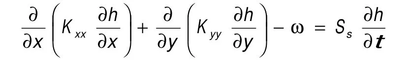
where, Kxx, the hydraulic conductivity along x, m/s;Kyy, the hydraulic conductivity along y, m/s;h-water head, m; ω-source sink term, m3/s;Ss-storage coefficient. The groundwater depth of Guantao Formation in 2010 is used as the initial condition of model: H(x,y,t)|t=0=H(x,y,t0), where t0-groundwater depth in 2010 (groundwater elevation have been changed to groundwater depth,Fig. 3). The boundary for the top and base is the zero-flow boundary. The lateral boundary condition is the constant flow boundary condition.

Fig. 3 Initial groundwater depth of study area
4 Model discretion
The rectangular mesh subdivision is used in this study. The study area can be subdivided into 51 rows and 44 columns. The length of sides is 0.2 km×0.2 km. There are 2 244 mesh units,including 1 206 valid units. Regardless of the effects of upper and lower strata, there is only one stratum in a vertical sense. The top and base elevation can be accepted by interpolation method according to the borehole data (Fig. 4).

Fig. 4 Mesh subdivision of model
5 Model identification and verification
This paper uses GMS (ZHU Xiao-bin, 2003;ZHANG Xin et al. 2015; LI Yu et al. 2014)software in the research process, and PEST toolkit for the inverse calculation of hydraulic conductivity and the model calibration and fitting.
There are fifteen monitoring wells within study area. From October 2010 to July 2015, there were fifteen identification and verification points. The hydraulic conductivity is 1.85 m/d, which served as the initial value of inverse calculation. The range of inverse calculation is 1.4-2.0 m/d. After calculation we got the distribution of hydraulic conductivity in study area (Fig. 5). The northeastern and southern parts of the study area have the high hydraulic conductivity of 2.0 m/d; the hydraulic conductivity in the middle part of study area falls within the scope of 1.4-1.5 m/d; for the majority of study area, hydraulic conductivity is 1.7-1.9 m/d.

Fig. 5 Distribution of hydraulic conductivity

Fig. 6 Comparison of calculated water depth and monitoring values
Fig. 6 compares the calculation value and observation value of groundwater depth in each well. As indicated in the figure, the simulation effects of calculation value and observation value of groundwater depth in fifteen observation wells during the simulation period are quite satisfactory,so the results are believable (Fig. 6).
6 Evaluation of exploitation
This paper specifies the principle for determining the permissible annual decrease rate of static groundwater level, which is within 50 years exploitation period, the static groundwater depth in Guantao Formation does not exceed 200 m. The development of geothermal water in the intensive exploitation zone of Xinji started in 1999. In 2015,the groundwater depth averaged 93.1 m. So the permissible annual decrease rate of static groundwater level will be defined as 3.14 m/a.
If the present exploitation continues (Table 1,the total exploitation quantity is 2 922 864 m3/a),the distribution of groundwater depth in November 2020 is described in Fig. 7. From the figure, we find that the exploitation of geothermal water will further drive down the groundwater level. At this time, the maximum groundwater depth comes close to 122 m, and the annual decrease rate of groundwater level is 5.5 m/a, which has exceeded the maximum permissible decrease rate of 3.14.Fig. 7 describes the distribution of groundwater level in November, 2049. At that time, the groundwater depth in study area will reach 282 m,and the annual decrease rate of groundwater level is 5.5 m/a, which is far above the maximum permissible groundwater depth. So we need to reduce the exploitation of the wells to meet the requirements for the maximum permissible groundwater depth.

Table 1 Exploration of wells
Table 1 details the adjusted exploitation for each well and the forecasted groundwater depth in 2 049. All the wells have reduced the exploitation and their total exploitation is 2 192 147 m3/a, about 75% of the present exploitation. In this case, the groundwater depth of each well averages 196 m,which meets the requirement for the maximum permissible groundwater depth.
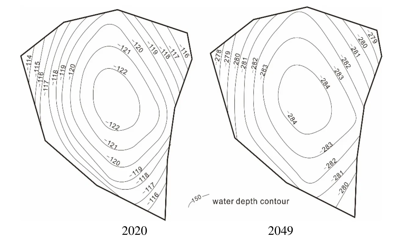
Fig. 7 Distribution of water depth
7 Conclusions
This paper, which focuses on the intensive exploitation area of geothermal resources in Xinji as the study area, develops numerical model of Guantao Formation, completes the inverse calculation of hydraulic conductivity with historical water level data, and optimizes the maximum permissible exploitation under the permissible decrease rate of water level. The research findings are described as follows:
(1) The hydraulic conductivity of thermal reservoir in Guantao Formation is in the range of 1.4-2.0 m/d. The northeastern and southern parts of the study area have the high hydraulic conductivity of 2.0 m/d; the hydraulic conductivity in the middle part of study area is within the scope of 1.4-1.5 m/d; for the majority of study area,hydraulic conductivity is 1.7-1.9 m/d.
(2) In this model, the simulation effects of fifteen identification and verification points in fifteen wells are quite satisfactory, and calculation value and observation value of groundwater depth show the same trend, so the results can be trusted.
(3) Within the fifty-year exploitation period,the maximum permissible exploitation of geothermal water in Guantao Formation is 2 192 147 m3/a, about 75% of the present exploitation when the static geothermal groundwater depth in Guantao Formation does not exceed 200 m.
This study offers a chance to visually understand the migration characteristics of geothermal water in Guantao Formation when exploitation continues, and provides the theoretical basis for designing the development and exploitation plan of geothermal water after the maximum permissible exploitation is calculated, so some valuable references are made available for those regions with similar problems. What’s more, because some data are unavailable, the model in this paper does not present the complete hydro-geologic units or consider the increased boundary recharge and the revolution of geothermal water temperature field as incurred by the water level decrease in study area. So future research is necessary to make improvements accordingly.
Acknowledgements
This study is supported by thermal response test (TRT) and numerical modeling with vertical ground heat exchanger in media sand (41302189),the research on the behavior characteristic of As and REE in high temperature geothermal fluid(1415042249) and geothermal survey of Xiamen-Qiongbei region in Southeast coastal(12120115045901).
杂志排行
地下水科学与工程(英文版)的其它文章
- Dynamic influence of Holocene characteristics on vadose water in typical region of central North China Plain
- Distribution characteristics and source of BTEX in groundwater in Guangzhou, Guangdong Province, P. R. China
- Exploration on compound water circulation system to solve water resources problems of North China Plain
- Evaluation of coordinated development of regional resources and economy around Shandong Peninsula urban agglomerations
- Evaluation of water resources carrying capacity of Gonghe basin based on fuzzy comprehensive evaluation method
- Comprehensive suitability evaluation of urban geological environment in Zhengzhou-Kaifeng area