Wind rotation characteristics of the upper tropospheric monsoon over the central and eastern tropical Pacific
2016-11-23LOUPnXingLIJinPingFENGJunZHAOSenndLIYnJie
LOU Pn-Xing, LI Jin-Ping, FENG Jun, ZHAO Sennd LI Yn-Jie
aState Key Laboratory of Numerical Modeling for Atmospheric Sciences and Geophysical Fluid Dynamics (LASG), Institute of Atmospheric Physics, Chinese Academy of Sciences, Beijing, China;bCollege of Global Change and Earth System Science (GCESS), Beijing Normal University,Beijing, China;cJoint Center for Global Change Studies, Beijing, China
Wind rotation characteristics of the upper tropospheric monsoon over the central and eastern tropical Pacific
LOU Pan-Xinga, LI Jian-Pingb,c, FENG Juanb,c, ZHAO Senaand LI Yan-Jiea
aState Key Laboratory of Numerical Modeling for Atmospheric Sciences and Geophysical Fluid Dynamics (LASG), Institute of Atmospheric Physics, Chinese Academy of Sciences, Beijing, China;bCollege of Global Change and Earth System Science (GCESS), Beijing Normal University,Beijing, China;cJoint Center for Global Change Studies, Beijing, China
In this study, to investigate whether the variation of wind direction in the upper tropospheric monsoon over the central and eastern tropical Pacifc shows similar characteristics to the classical monsoon region, the authors introduced a wind vector angle methodology that describes the size of the angle of the wind direction variation, as well as the directed rotary angle, which includes not only the size of the angle but also how the wind vector rotates. On this basis, the authors utilized and improved the directed rotary angle methodology to investigate the evolution of wind direction in detail, and the study confrmed the presence of the same four rotation features in the upper tropospheric monsoon region. Furthermore, the authors also identifed the precise variation of wind direction in pentads with seasonal evolution, and found the onset time of the upper tropospheric monsoon may be earlier than the classical monsoon while the termination time may be later. The results further support and supplement the theory of global monsoons, which unifes the low-level and upper tropospheric monsoon as one monsoon system.
ARTICLE HISTORY
Revised 14 July 2016
Accepted 14 July 2016
Wind direction; wind vector angle; directed rotary angle;upper tropospheric monsoon
在本文中,为研究赤道中东太平洋区域上对流层季风是否具有和经典季风同样的风向变化特征,我们引入一种风向角的研究方法——有向转角法,该方法不仅可以刻画风向变化的角度大小,而且包含风矢量如何转变的信息。在此基础上,利用该方法并将其适当推广,本文研究了赤道中东太平洋区域上对流层季风的演变过程,结果证实了该区域上对流层季风具有和经典季风同样的四种转变特征,并进一步给出了随季节转换不同时期内的风向演变结果,发现上对流层季风相对经典季风具有爆发时间较早并结束较晚的特点。本文结果是对全球季风系统理论的有益补充,进一步支持该理论将全球不同季风作为一个整体系统来看待。
1. Introduction
Monsoon regions are generally thought of as low-level tropospheric areas satisfying the criteria of wind reversal and precipitation changes with the seasons (Ramage 1971;Webster et al. 1998). So, the variation in wind direction with the transition of the seasons is an important aspect of monsoon research (Chuang 1986; Fu and Fletcher 1988; Xie et al. 1998; Qian and Yang 2000; Jones and Carvalho 2002;Corrigan, Ramanathan, and Schauer 2006; Zhang and Li 2008, 2010), and methods involving the wind vector angle can usually be applied to investigate such variation (Zhang and Li 2010; Jiang and Li 2011), given that it is one of the criteria infuencing the onset of monsoon.
The wind vector angle is defned as the angle between diferent wind vectors, indicating the absolute angle size of the wind vector with reference to the initial wind. It implies the fnal state of the variation in wind direction, but it also includes noting how the wind vector changes over time.
To accurately refect the process of the wind vector changes over time, the directed rotary angle was proposed(Zhang and Li 2008) to study the dynamic characteristics of wind direction variation in diferent monsoon regions,and evaluate the performance of AMIP models in simulating monsoon (Zhang and Li 2008; Li and Zhang 2009). Specifcally, if the absolute value of the directed rotary angle exceeds the given criterion, it indicates monsoon onset (Li and Zhang 2009), whereas if it remains below the criterion it indicates monsoon withdrawal.
Given that the variation in the direction of wind at a particular point and pressure level can be characterized by the rotation of the wind vector, it can thus be defned that the angles of variation are positive if the rotation of thedaily (or hourly/monthly) wind vector is counterclockwise compared to the reference wind (e.g. January climatological wind vector), or negative if the rotation is clockwise. Consequently, we can obtain all the angles of variation at each moment in a particular period (e.g. a few months or an annual cycle). Put simply, it precisely shows the evolution of wind direction for each time increment, including how the wind vector rotates (clockwise or counterclockwise),and the size of the angle of the wind direction variation,therefore refecting the dynamic characteristics of wind direction much better with the evolution of the seasons.
Based on this concept, Zhang and Li (2008) stated that the annual cycle of the variation in wind direction can be categorized as follows: (i) the wind vector frst rotates clockwise until the absolute size of the angle (positive or negative) exceeds a critical value (e.g. 90°), and then rotates counterclockwise back to the initial state after a certain period; (ii) the wind vector frst rotates counterclockwise until the absolute size of the angle exceeds a critical value,and then rotates clockwise back to the initial state; (iii) the wind vector rotates clockwise all the time until it returns to the initial state; (iv) the wind vector rotates counterclockwise all the time until it returns to the initial state; (v) there is no evident variation or small-amplitude rotation, called ‘stable rotation'; (vi) there is neither inconsistent nor irregular rotation, called ‘unstable rotation'. In particular, they noted that, considering the seasonal reversal of wind in monsoon regions, type (v) and (vi) could be ruled out, meaning only types (i)—(iv) can exist in monsoon regions, in theory.
Additionally, previous studies (Li and Zeng 2000, 2002,2003, 2005) demonstrated that, in the upper troposphere over the central and eastern tropical Pacifc (5°S—22.5°N,85°—175°W) (hereafter referred to as CETP), the prevailing wind direction rotates more than 90° in summer, with reference to winter, as the seasons evolve. Indeed, according to the monsoon index defned in Li and Zeng (2002, 2005),the upper troposphere over the CETP can be regarded as a non-classical monsoon region.
Therefore, in the present work, we applied the methodology of the directed rotary angle to identify more detailed features of the variation in wind direction over this region,and determine whether these features show any similarities to their counterparts in the classical monsoon region of the low-level troposphere.
2. Data and methodology
2.1. Data
This work used the global four-times-daily NCEP-1 and monthly NCEP-2 multi-level atmospheric wind felds with a 2.5° × 2.5° resolution in the horizontal direction and 17 pressure levels from 1000 to 10 hPa. These data were obtained from the NCEP—NCAR reanalysis datasets (Kalnay et al. 1996; Kanamitsu et al. 2002).
2.2. Methodology
It was already known that the wind vector angle indicates the angle size of the wind vector with reference to the initial state when it eventually stops varying during a particular period (e.g. one day or one month). It has a strict defnition (Zhang and Li 2008; Li and Zhang 2009),as shown below:
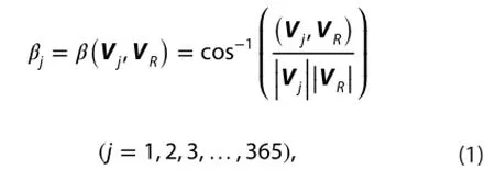
Also, it is obvious that the actual value of βjshould not exceed 180° and should always be positive, according to the defnition of Equation (1). The defnition simply describes the angle size of the wind vector at the end with reference to the initial wind, and does not consider the wind vector direction of rotation.
It is possible that the wind vector rotates clockwise over 200° and then rotates back 50° in a certain period, or the wind vector just rotates counterclockwise 150°. In both cases, frstly, the former actual variation value of the angle reaches 200°; and secondly, both sizes of angle variation are equal to 150° at the end, according to Equation (1), when in fact they represent totally diferent rotation situations.
This consequence is caused by the loss of information contained in the variation process without considering the clockwise or counterclockwise rotation; as a result, how the wind direction evolved in detail is missed. Therefore,the directed rotary angle was introduced (Zhang and Li 2008; Li and Zhang 2009), presented by Equations (2) and(3), below:
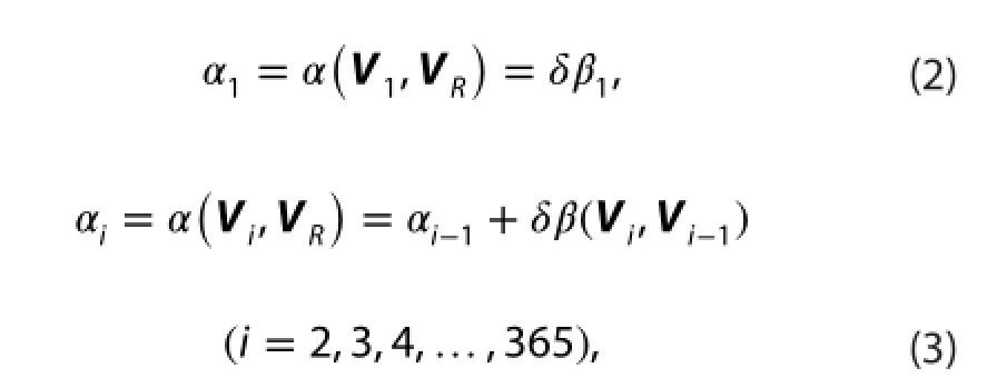
So all of the αivalues for a whole year at a given location can be obtained based on Equations (2) and (3). Then theαi,as well as the directed rotary angle, fnally includes the direction of rotation (counterclockwise or clockwise). The actual value of αivaries most likely to exceed 180° or even less than -180° when it increases or decreases with time(every day or hour).
In climatological terms, when the absolute value of the directed rotary angle continues to increase or decrease, it means the wind reversal begins from winter to summer, or vice versa, i.e. monsoon onset or withdrawal. Thus, it can describe the wind rotation variation in more detail.
3. Results
Figure 1 separately shows the four typical rotation features of the directed rotary angle in the monsoon region(at 300 hPa) in upper troposphere over the CETP, including types (i)—(iv). As expected, the same rotation features as the classical monsoon (Zhang and Li 2008) are presented in the lower troposphere. Also, it shows the rotation of the wind vector in the upper tropospheric monsoon changes according to the same pattern with seasonal evolution. However, compared to the results in the low-level tropospheric monsoon (Zhang and Li 2008), the directed rotary angle variation (Figure 1(a) and (c)) shows in a relatively shorter time that the wind can change from the prevailing wind direction in winter to the prevailing wind direction in summer. This means that the seasonal wind reversal may happen in less time than in the lower troposphericmonsoon, which translates to the onset and withdrawal of the upper tropospheric monsoon possibly being extremely sudden and quick.
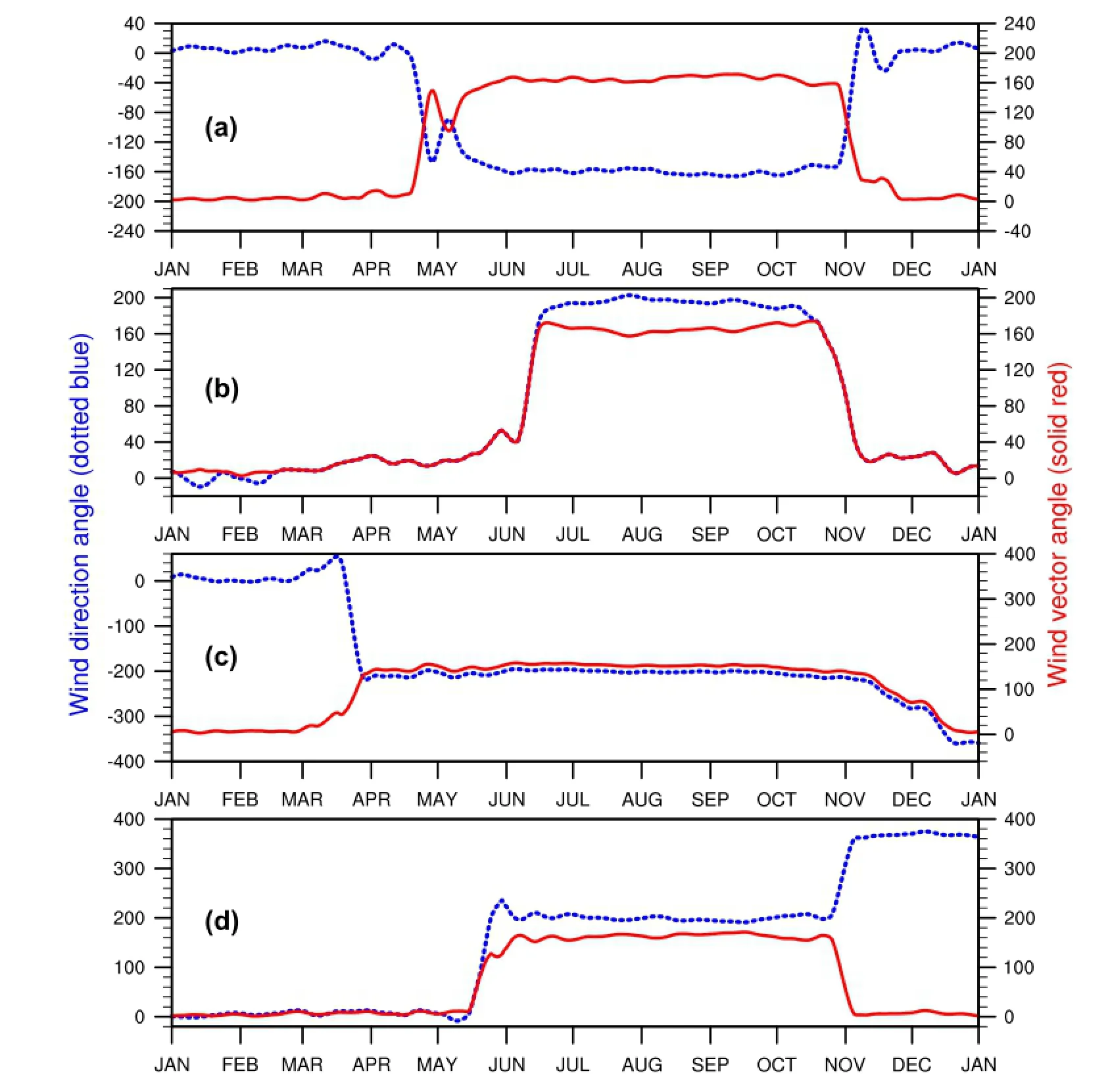
Figure 1.The four typical rotation features over the central and eastern tropical Pacifc: (a) type (i) (5°N, 130°W); (b) type (ii) (5°N, 160°W);(c) type (iii) (5°N, 95°W); (d) type (iv) (5°N, 145°W).
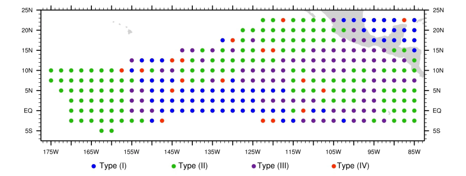
Figure 2.The four rotation types at each point over the CETP at 300 hPa.
Also, in the upper troposphere, the seasonal wind reversal starts from winter to summer before May or eventually before April (Figure 1(a) and (c)), while the opposite process starts later than the middle of October (Figure 1). This indicates that the monsoon onset time is earlier, and withdrawal is later, than in the low-level monsoons, so the upper troposphere monsoon may last longer.
Since all four typical rotation types (Figure 1) are shown at diferent locations, we seek to identify what rotation types are at all points in the whole region. Therefore, in the following analysis (Figure 2), we show the rotation type distribution over the whole CETP at 300 hPa.
First, and most obviously, type (i) (frst rotates counterclockwise then clockwise; blue dots) and type (ii) (frst rotates clockwise then counterclockwise; green dots) are comparatively more frequent than type (iii) (fully clockwise; purple dot) and type (iv) (fully counterclockwise; red dots); type (iv) is particularly rare.
Additionally, we can see that, in the western district(155°—175°W) of the CETP, the wind rotation features are type (ii) (green dots); and if we ignore the northeastern district (over continental North America), only in the middle of the CETP do the wind rotation features belong to type (i) (blue dots).
In the east of the CETP, the rotation features are very irregular. There are mainly mixed type (ii) (green dots) and type (iii) (purple dots) in general, and only at some rare individual sites they are type (iv) (red dots).
Figure 2 shows the diferent wind rotation types in a specifed location (or a specifed area) in the annual cycle and Figure 1 shows the dynamic characteristics with one-dimensional time series. We further expand this method to two dimensions to investigate the upper monsoon onset and withdrawal with the directed rotary angle. The two-dimensional directed rotary angle evolution is therefore given to show the process of the winter to the summer (Figure 3) and the reverse process(Figure 4).
Figure 3 shows the directed rotary angle in the occurrence and early developments stages of the upper tropospheric monsoon. It can be seen that, in diferent locations,the time of the directed rotary angle exceeding the criterion is not that consistent. Generally, it is earlier in the east and later in the west.
More specifcally, it can be seen that the monsoon onset frstly and primarily takes place in the east the region (Figure 3(a)) by earlier May, and it almost accomplishes the seasonal wind reversal in the eastern area (5°S—10°N, 85°—130°W) by May. Then, it gradually expands to the middle and north of the region; basically, it accomplishes wind reversal over most of the region by mid to late May (Figure 3(c)), and fnishes by late June over the whole region.
Figure 4 shows the beginning and development of the monsoon withdrawal in the upper tropospheric. The results show that the wind starts to decay by mid to late October(Figure 4(a) and (b)), and that it happens both in the marginal zone and in the center of the region (120°—150°W). Then, it expands in the west (155°—175°W) (Figure 4(c)). By the middle of November, most of the region has fnished its wind reversal, apart from a small fraction in the east(95°—115°W) near the equator.
Moreover, Figures 3 and 4 show not only the development of monsoon onset and withdrawal, but also partly reveal a similar spatial pattern of the rotation types as Figure 2. The residual dark purple shading and sporadic red shading (Figure 4(c) and (d)) are highly consistent with the type (iii) and type (iv), respectively.
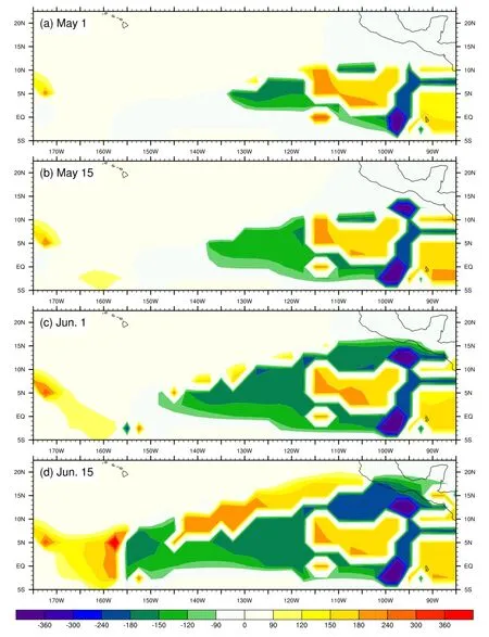
Figure 3.Directed rotary angle evolution over the CETP at 300 hPa from the winter to the summer.

Figure 4.Directed rotary angle evolution over the CETP at 300 hPa from the summer to the winter.
Besides, Figures 3 and 4 also confirm the earlier monsoon onset and later monsoon withdrawal more clearly. Furthermore, the earlier onset date is different from the low-level tropospheric monsoons. A number of previous studies have noted that the monsoon onset dates in the lower tropospheric monsoons are relatively earlier. Specifically, the earliest onset date of the Asian summer monsoon often occurs in the central IndochinaPeninsula in late April or early May (Ding 2004; Ding and Chan 2005); the East Asian summer monsoon average onset date in South China is in early May (Zhu et al. 2000); the South China Sea summer monsoon onset date is basically after mid-May or early June (Zhu et al. 2000; Wang et al. 2004); and the Indian summer monsoon average onset date is in early June, observed at Kerala (Wang, Ding, and Joseph 2009). The earlier transition time could be a precursor to the low-level monsoon onset.
4. Conclusion
In this study we used two diferent angle defnitions to reveal the wind vector direction variation, and demonstrated the wind in the upper tropospheric monsoon over the CETP has the same four typical rotation features as the low-level monsoon. At the same time, we also revealed the rotation pattern types across the entire region. The results provide further evidence that the circulation in the upper troposphere over the CETP is monsoonal circulation, and supports the theory of global monsoons,proposed by Li and Zeng (2003), in which the lower and upper tropospheric monsoons are regarded as one system.
Additionally, we improved the directed rotary angle to characterize the entire wind reversal process in the upper tropospheric monsoon for the frst time, and found that the upper tropospheric monsoon onset is earlier and the withdrawal time is later. In particular, the earlier onset time may serve as an indicator for the prediction of the lower tropospheric monsoon onset date, which is worthy of further study.
Disclosure statement
No potential confict of interest was reported by the authors.
Funding
This work was jointly supported by the National Natural Science Foundation of China Projects (41530424) and SOA Program on Global Change and Air-Sea Interactions (GASI-IPOVAI-03).
References
Chuang, W.-S. 1986. “A Note on the Driving Mechanisms of Current in the Taiwan Strait.” Journal of the Oceanographical Society of Japan 42 (5): 355—361. doi:10.1007/BF02110430.
Corrigan, C. E., V. Ramanathan, and J. J. Schauer. 2006. “Impact of Monsoon Transitions on the Physical and Optical Properties of Aerosols.” Journal of Geophysical Research: Atmospheres 111(D18): D18208. doi:10.1029/2005JD006370.
Ding, Y. H. 2004. “Seasonal March of the East Asian Summer Monsoon.” In The East Asian Monsoon, edited by C.-P. Chang,3—53. Singapore: World Scientifc Publisher.
Ding, Y. H., and J. C. L. Chan. 2005. “The East Asian Summer Monsoon: An Overview.” Meteorology and Atmospheric Physics 89 (1—4): 117—142. doi:10.1007/s00703-005-0125-z.
Fu, C., and J. O. Fletcher. 1988. “Large Signals of Climatic Variation over the Ocean in the Asian Monsoon Region.” Advances in Atmospheric Sciences 5 (4): 389—404. doi:10.1007/BF02656786.
Jiang, X. W., and J. P. Li. 2011. “Infuence of the Annual Cycle of Sea Surface Temperature on the Monsoon Onset.” Journal of Geophysical Research 116 (D10): 1—14. doi:10.1029/2010JD015236.
Jones, C., and L. M. V. Carvalho. 2002. “Active and Break Phases in the South American Monsoon System.” Journal of Climate 15 (8): 905—914. doi:10.1175/1520-0442(2002)015<0905:AAB PIT>2.0.CO;2.
Kalnay, E., M. Kanamitsu, R. Kistler, W. Collins, D. Deaven, L. Gandin,M. Iredell, et al. 1996. “The NCEP/NCAR 40-Year Reanalysis Project.” Bulletin of the American Meteorological Society 77 (3): 437—471. doi:10.1175/1520-0477(1996)077<0437:TNYRP>2. 0.CO;2.
由于存在较大的横向冷却表面(泄水建筑物溢洪道侧墙)有助于水分向冻结方向移动,所以在溢洪道侧墙边界处形成很大的湿热梯度并在附近形成浸润线,所以这种情况下的问题相当复杂。
Kanamitsu, M., W. Ebisuzaki, J. Woollen, S.-K. Yang, J. J. Hnilo,M. Fiorino, and G. L. Potter. 2002. “NCEP-DOE AMIP-II Reanalysis (R-2).” Bulletin of the American Meteorological Society 83 (11): 1631—1643.
Li, J. P., and Q. C. Zeng. 2000. “Signifcance of the Normalized Seasonality of Wind Field and Its Rationality for Characterizing the Monsoon.” Science in China Series D: Earth Sciences 43 (6): 646—653.
Li, J. P., and Q. C. Zeng. 2002. “A Unifed Monsoon Index.”Geophysical Research Letters 29 (8): 1151—1154. doi:10.1029/ 2001GL013874.
Li, J. P., and Q. C. Zeng. 2003. “A New Monsoon Index and the Geographical Distribution of the Global Monsoons.” Advances in Atmospheric Sciences 20 (2): 299—302. doi:10.1007/s00376-003-0016-5.
Li, J. P., and Q. C. Zeng. 2005. “A New Monsoon Index, Its Interannual Variability and Relation with Monsoon Precipitation.” [In Chniese.] Climatic and Environmental Research 10 (3): 351—365.
Li, J. P., and L. Zhang. 2009. “Wind Onset and Withdrawal of Asian Summer Monsoon and Their Simulated Performance in AMIP Models.” Climate Dynamics 32 (7—8): 935—968. doi:10.1007/ s00382-008-0465-8.
Ramage, C. S. 1971. Monsoon Meteorology. Vol. 15. New York: Academic Press.
Wang, B., Q. H. Ding, and P. V. Joseph. 2009. “Objective Defnition of the Indian Summer Monsoon Onset.” Journal of Climate 22(12): 3303—3316. doi:10.1175/2008JCLI2675.1.
Wang, B., L. Ho, Y. S. Zhang, and M. M. Lu. 2004. “Defnition of South China Sea Monsoon Onset and Commencement of the East Asia Summer Monsoon.” Journal of Climate 17 (4): 699—710. doi:10.1175/2932.1.
Webster, P. J., V. O. Magana, T. N. Palmer, J. Shukla, R. A. Tomas,M. Yanai, and T. Yasunari. 1998. “Monsoons: Processes,Predictability, and the Prospects for Prediction.” Journal of Geophysical Research: Oceans 103 (C7): 14451—14510. doi:10.1029/97JC02719.
Xie, A., Y.-S. Chung, X. Liu, and Q. Ye. 1998. “The Interannual Variations of the Summer Monsoon Onset Overthe South China Sea.” Theoretical and Applied Climatology 59 (3—4): 201—213. doi:10.1007/s007040050024.
Zhang, L., and J. P. Li. 2008. “The Application of the Variation Characteristics of Wind Direction in Evaluating Monsoon Simulation.” Chinese Journal of Atmospheric Sciences (in Chinese)32 (1): 53—66. doi:10.3878/j.issn.1006-9895.2008.01.05.
Zhang, L., and J. P. Li. 2010. “Twice Wind Onsets of Monsoon over the Western North Pacifc and Their Simulations in AMIP Models.” International Journal of Climatology 30 (4): 582—600. doi:10.1002/joc.1908.
Zhu, H., M. Cui, X. Bai, and A. Klaus. 2000. “East Asia Summer Monsoon Onset Date Calculated from Observed, Reanalyzed and Combined Daily Rainfall.” Journal of Tropical Meteorology 6 (1): 100—105.
风向; 风向角; 有向转角; 上对流层季风
30 May 2016
CONTACT LI Jian-Ping ljp@bnu.edu.cn
© 2016 The Author(s). Published by Informa UK Limited, trading as Taylor & Francis Group.
This is an Open Access article distributed under the terms of the Creative Commons Attribution License (http://creativecommons.org/licenses/by/4.0/), which permits unrestricted use, distribution, and reproduction in any medium, provided the original work is properly cited.
猜你喜欢
杂志排行
Atmospheric and Oceanic Science Letters的其它文章
- Parameterizing an agricultural production model for simulating nitrous oxide emissions in a wheat-maize system in the North China Plain
- Response of fne particulate matter to reductions in anthropogenic emissions in Beijing during the 2014 Asia-Pacifc Economic Cooperation summit
- Contrasting two spring SST predictors for the number of western North Pacific tropical cyclones
- The impact of solar activity on the 2015/16 El Niño event
- Quantifying the attribution of model bias in simulating summer hot days in China with IAP AGCM 4.1
- Model analysis of secondary organic aerosol over China with a regional air quality modeling system (RAMS-CMAQ)
