Accumulation conditions of outside source heavy oil in Nepa-Botuoba Sub-basin, Russia and prediction of distribution
2016-10-31XUJianhuaSHANXuanlongDUShangHEWentongandLIANGYe
XU Jianhua, SHAN Xuanlong, DU Shang, HE Wentong and LIANG Ye
College of Earth Sciences, Jilin University, Changchun 130061, China
10.3969/j.issn.1673-9736.2016.03.01
Accumulation conditions of outside source heavy oil in Nepa-Botuoba Sub-basin, Russia and prediction of distribution
XU Jianhua, SHAN Xuanlong*, DU Shang, HE Wentong and LIANG Ye
CollegeofEarthSciences,JilinUniversity,Changchun130061,China
In terms of tectonic evolution and petroleum geological conditions of the Nepa-Botuoba Sub-basin and its adjacent sub-basins, the accumulation conditions of the heavy oil were analyzed. The studied area had plenty of oil and gas accumulation, but there were no developed source rocks. It is a typical outside source accumulation, whose origins from thick high-quality source rock deposited in the adjacent sub-basins. The shallow layer has favorable heavy oil reservoir conditions and poor sealing conditions, which benefits the thickening of hydrocarbon. The multi-periods of structural compression not only uplifted the studied area drastically, but also created a series of fault zones and large-scale slope belt. The structural compression also provided channel and sufficient power for migration of hydrocarbon to shallow layers. Based on these conditions, the favorable accumulation zone of heavy oil was predicted, which provided direction for heavy oil exploration in Nepa-Botuoba Sub-basin.
Nepa-Botuoba Sub-basin; heavy oil; outside source accumulation; favorable accumulation zone
0 Introduction
The heavy oil is the unconventional energy with great recoverable potential, and it plays a more and more important role in industrialization (Yangetal., 2006; Heetal., 2015). Orogenic belt on the periphery of Siberia is one of four largest heavy oil enrichment orogenic belts worldwide. According to the latest evaluation of heavy oil resource, the East Siberian Basin has heavy oil resource of 2.69×10¹²barrels (Maetal., 2015), which is a great potential. At present, not much exploration, however, has been carried out in this area. The study of heavy oil in the Nepa-Botuoba Sub-basin, the largest hydrocarbon accumulation area in the East Siberian Basin, is still poor. In recent years, large-scale heavy oil accumulation belts have been found successively in sub-basin of the East Siberian Basin. Comparatively, the Nepa-Botuoba Sub-basin has similar geological conditions and structural activities. Although the source rock was not developed inside the basin, the thick high quality source rocks in the neighboring areas provide sufficient hydrocarbon to the basin. Based on IHS data, and study result of conventional hydrocarbon in the area is summarized and favorable conditions of heavy oil accumulation in the Nepa-Botuoba Sub-basin are investigated to predict favorable distribution area of heavy oil, hopefully providing reference for exploration of heavy oil.
1 Overview of Nepa-Botuoba sub-basin
The Nepa-Botuoba Sub-basin, located in the middle of Russia, is a sub-basin of the East Siberian Basin, and it is an intracratonic marginal basin, with an area around 1.68×10⁵km2and coordinate interval of 56°--64°N and 104°--116°E. The sub-basin extends in NE-SW direction. Its administrative region includes Irkutsk Oblast, the Sakha(Yakutia)Republic, and a small part of frontier of Krasnoyarsk(IHS, 2008).
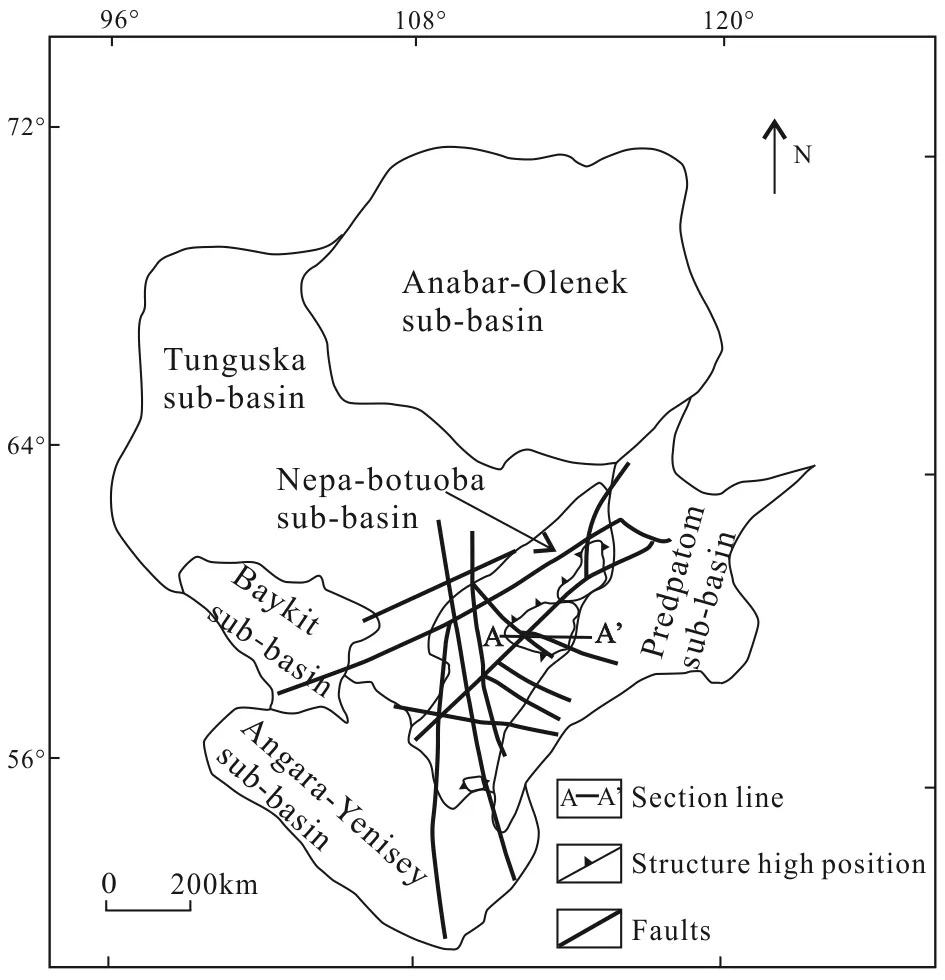
Fig.1 Sketch map on geographic location and geological structures of Nepa-Botuoba Sub-basin (after IHS, 2008)
The Nepa-Botuoba Sub-basin is the located in the southwest of the East Siberian Basin, and it is adjacent to other three depression units. It borders on the Predpatom Sub-basin in the east and south, it is close to the Tunguska Sub-basin in the northwest, and it is adjacent to the Angara-Yenisey Sub-basin in the southwest (Fig.1). In terms of tectonic unit, the Nepa-Botuoba Sub-basin, compared with the neighboring sub-basins, is located in structural high point, and has favorable direction of hydrocarbon migration (Guetal., 2007). There is several uplift structures developed inside the studied area, and the orientation of uplift axis is basically consistent with the extension of the studied area.
2 Structural evolution and formation development
The structural evolution of the studied area and its neighboring sub-basins dated from Riphean, mainly including two periods of structural subsidence and three periods of structural uplift, forming the situation of one uplift lying between three depressions nowadays. Thus, the sedimentary cap rocks are mainly of the Vendian and Cambrian formation, and Ordovician formation has been developed in this region. Moreover, Riphean and other formations are entirely absent.
The initial structural subsidence occurred in the Riphean. Affected by splitting of the Rodinia, the rift valley was widely developed inside the East Siberian Basin, forming a series of grabens. Thus, the basin had been formed and filling of sediment began. The structural subsidence resulted in the seawater invading the basin from south to north, forming the Paleo-Asian Ocean. Affected by transgression, the sediments in the studied area and its neighboring areas were transformed from terrestrial clasolite to neritic bioherm carbonatite (Tao, 2012).
Later, during the late Riphean--early Vendian, the Baikalian Orogeny, affected by plate subducting, started in southwest margin of the East Siberian Basin, and the first entire structural uplift in the studied area occurred because of compression force. Then, the Riphean formation subsided earlier is uplifted to structural high part and was totally corroded (Fig.2). Comparatively, the compressed formation in Predpatom area dived and collided with the studied area to form the large-scale slope belt, and the Riphean formation was well preserved. The southwest margin of the East Siberian Basin was lifted by structural uplifting. In the early Vendian, the sediment inside the area is mainly terrigenous clasolite.
After plate collision, the subduction zone in the south margin of basin retreated, and the whole East Si-berian Basin was under geostress relaxation and entered the second-period of tectonic subsidence, and the large-scale transgression occurred. The sedimentary formation was transformed from terrigenous clasolite to neritic carbonatite.
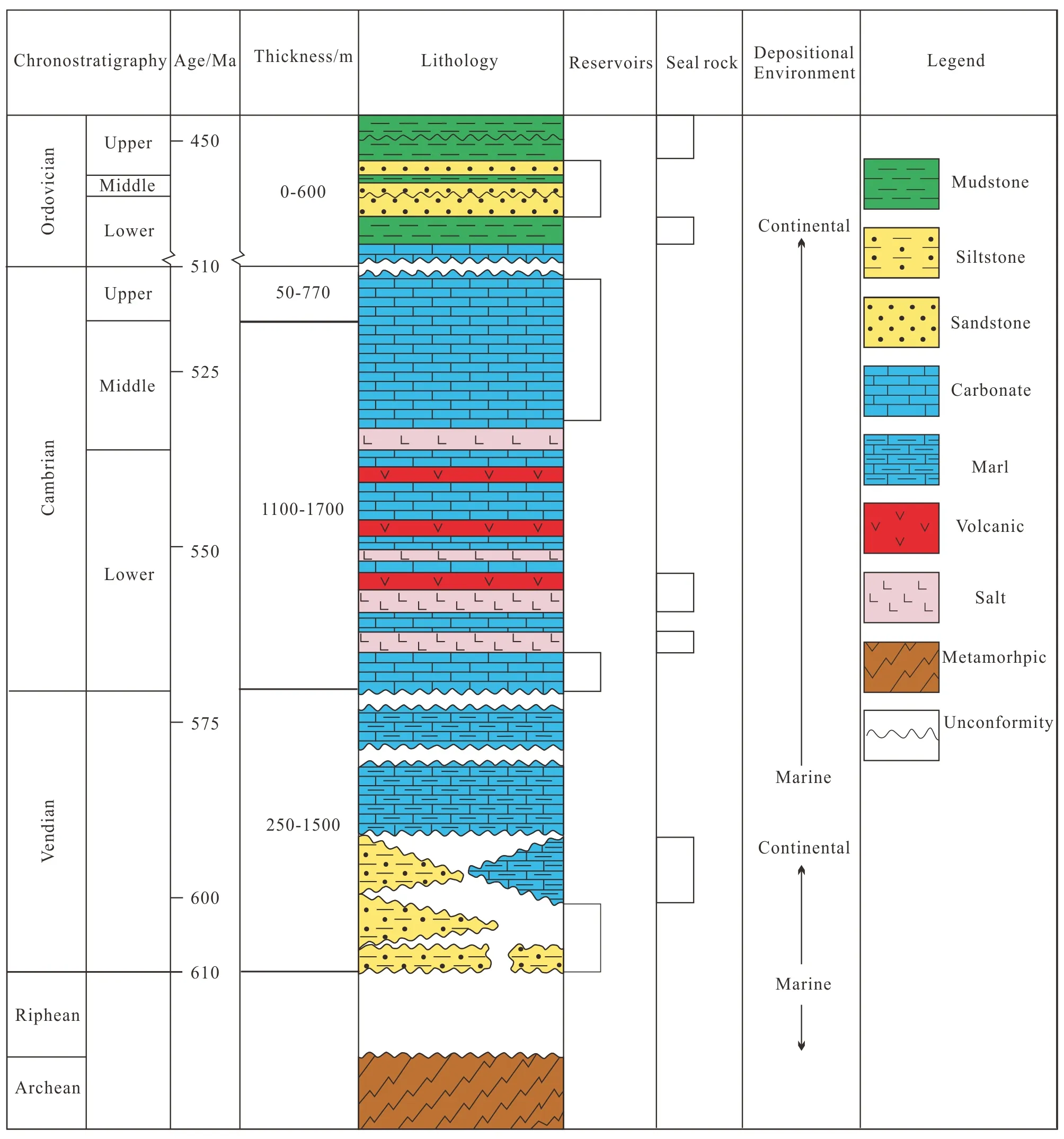
Fig.2 Histogram of Nepa-Botuoba Sub-basin (after IHS, 2008)
During Middle Cambrian-Lower Ordovician, affected by collision between micro-continents, the studied area was uplifted for the second time. Because of vibration of seawater, multiple sedimentary cycles of carbonatite-evaporite were developed, and the sediment in Lower Ordovician was transformed to most of terrigenous clasolite.
Since Devonian, affected by collision between the Siberian and the Kazakhstan Continent and several periods of collision between micro-plates of Siberian Basin, the ocean began to close, making the anticline uplifted successively drastically. The regional uplift made the earlier sedimentary strata denuded, and the sedimentary range of the Nepa-Botuoba Sub-basin decreased. Thus, the formation deposited after Devonian was totally absent. Meanwhile, because of collision, the basement fault zone was activated and salinastone formation was cut, forming the present structural situation.
3 Analysis of accumulation conditions of outside source heavy oil
Affected by structural uplift in the late Riphean, the Riphean formation rich in organic matter in the Nepa-Botuoba Sub-basin was almost denuded. A large amount of drilling data showed that there is no Riphean formation. The organic carbon content of the Vendian formation deposited later is <0.1%. Referenced to source rock evaluation standard (Daietal., 2008), the Vendian formation had poor conditions of source rock, which was not capable of providing oil source for large-scale hydrocarbon accumulation. Cambrian formation is the potential source rock having TOC around 0.2%, and it had maximum burial depth of merely 2 500 m in burial history with R0<0.55, which did not reach oil generation threshold (Tellus, 2009). In conclusion, the favorable source rock was not developed, but there is large-scale hydrocarbon accumulation, which shows that the favorable source rock in the neighboring depression units provided abundant oil source.
3.1Development of source rocks in neighboring sub-basin
Although in the neighboring areas there were three effective source rock distribution areas and two main hydrocarbon generation kitchens: the Riphean and the lower-middle Cambrian ones (Fig.3). However, the previous study of biomarker showed that all hydrocarbons in the studied areas were from Riphean formation (C & C Reservoirs, 2009). The Riphean formation of Tunguska Sub-basin was mainly deposited in the northwest margin and average TOC is less than 0.1%, which was not capable of generating hydrocarbon. In Angara-Yenisey Sub-basin, the Riphean source rock was developed and reached oil generation threshold, but the Riphean neritic formation was developed in the northwest and southeast part, and pinched out in the middle and east. The Riphean formation was lost in the middle and east part of Angara-Yenisey Sub-basin, and the overlaying Vendian shale sheltered lateral migration of hydrocarbon. The fluid potential resulted from formation static pressure in depression structural unit resulted in hydrocarbon migrating to the northwest slope belt of Angara-Yenisey Sub-basin. Comprehensive analysis showed that only Riphean hydrocarbon generation kitchen in the Predpatom Sub-basin provided oil source for the studied area (Table 1).
The source rock in the Predpatom Sub-basin was mainly the Riphean neritic formation, and it was developed in the north side. The Riphean formation in Predpatom area included three sets of source rocks, two of which had single thickness of over 900 m. Moreover, the quality and thickness improved gradually while entering the depression in the south (Zhuetal.,2012). The organic matter was mainly type Ⅱ. The lithology was mainly asphaltene shale, mudstone and bioherm carbonatite. TOC in mudstone was over 20%, and 0.5%--1.5% carbonatite with HI over 300 mg HC/g TOC, generally. As the Predpatom Sub-basin entered transgression in the Riphean, black pyrobituminous shale, clay and carbonatite were widely developed under oxygen deficient condition. The Riphean source rock subsided rapidly in the Vendian and reached the stage of maturity (Tellus, 2009), with oil generation window depth between 3 000--5 500 m, and a large amount of hydrocarbon was expelled. The plane of unconformity resulted from depositional break in the early Vendian and a big set of sandbody in the Vendian provided favorable channel for lateral hydrocarbon migration to the studied area, and large-scale depression-uplift structure and compression provided favorable hydrocarbon direction and dynamics for source rock in the Predpatom Sub-basin which contributed oil source to the studied area. The secondary source rock in the Predpatom Sub-basin was the Vendian thin layer shale.

Table 1 Effective statistics of contribution of neighboring area to the studied area
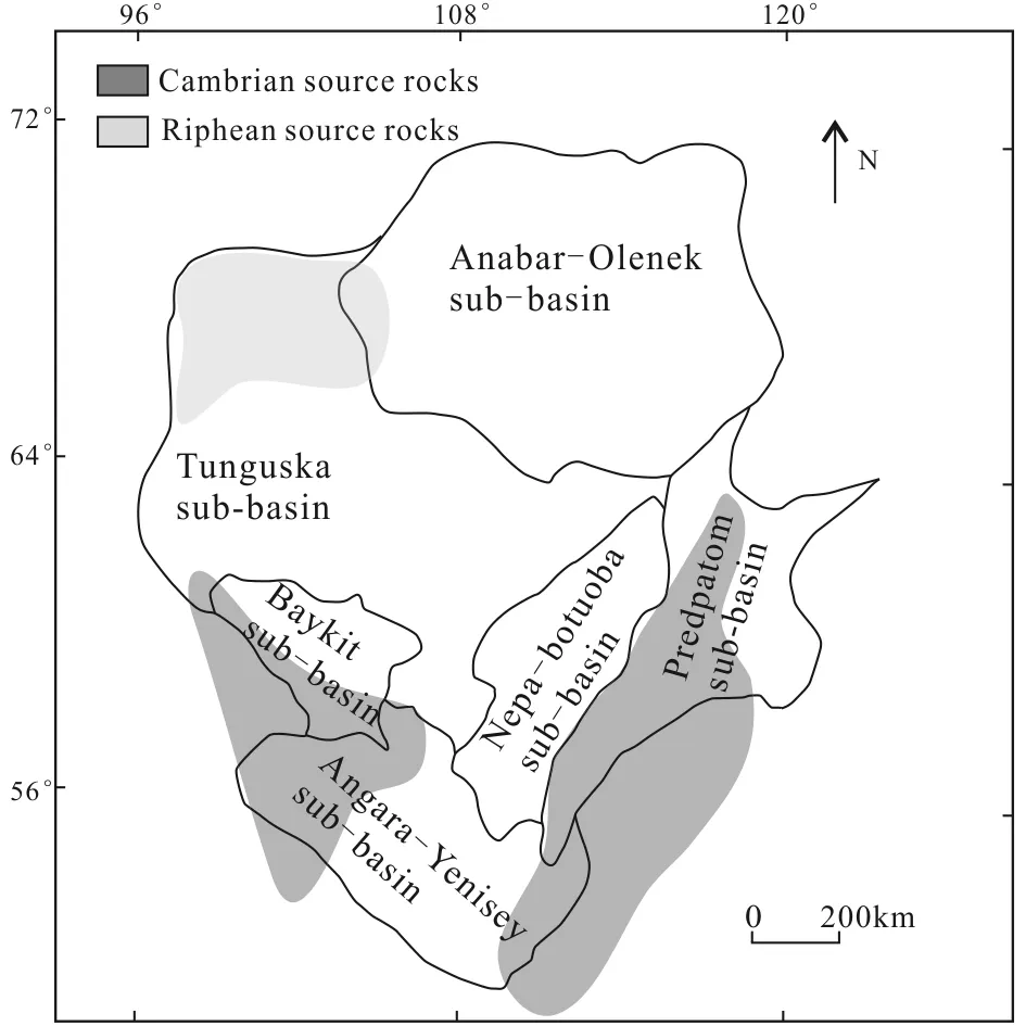
Fig.3 Distribution of main source rock (after IHS, 2008; C & C reservoirs, 2009)
3.2Shallow burial upper-salinastone reservoir and poor seal-capping
The stratigraphic division was based on the middle Cambrian salinastone, and the reservoir space was divided into the under-salinastone, the inter-salinastone, and the upper-salinastone ones. The upper-salinastone reservoir space and the inter-salinastone one in uplift had characteristics of shallow burial and was subject to oxidation, water washing and biodegradation, it was effective space of accumulating heavy oil (Xuetal., 2014). However, all hydrocarbon in under-salinastone reservoir space, based on available exploration data, was conventional one (IHS, 2008).
The upper-salinastone and the inter-salinastone reservoir space in uplift were the middle-upper Cambrian carbonatite and the middle Cambrian carbonatite respectively, with maximum thickness of 400 m. The reservoir space had similar physical properties because of similar burial depth, high dolomitization and connection with formation water, and their porosity was between 18%--25% because of dolomitization and dissolution, which was middle-high one. The permeability was between 15--870 mD, which was middle-high one. Under fracturing, the favorable reservoir space over 1 000 mD will be formed regionally (Mel’nikovetal., 2008).
As for cap rock, the effective cap rock of the upper-salinastone reservoir space had Ordovician mudstone, and it had poor sealing condition because of small thickness and shallow burial. The effective cap rock of the inter-salinastone reservoir space in uplift was salinastone. Moreover, because of compression and uplift after Devonian, the plastic flow occurred in salinastone of core, and the cap rock in core of anticline was thinner (Fig.4) and the burial was shallower, which had poor sealing condition.
3.3Migrations of oil
In the Riphean, a small part of the Riphean source rock reached the stage of maturity, and a small amount of hydrocarbon was generated. A large amount of hydrocarbon was generated and expelled in the early Vendian, and the formation subsided rapidly, and the Riphean source rock reached threshold of oil generation, with large range of hydrocarbon generation period. The hydrocarbon was generated between the Ven-dian and Triassic. Since then, the hydrocarbon had experienced two times of migration (Fig.5).
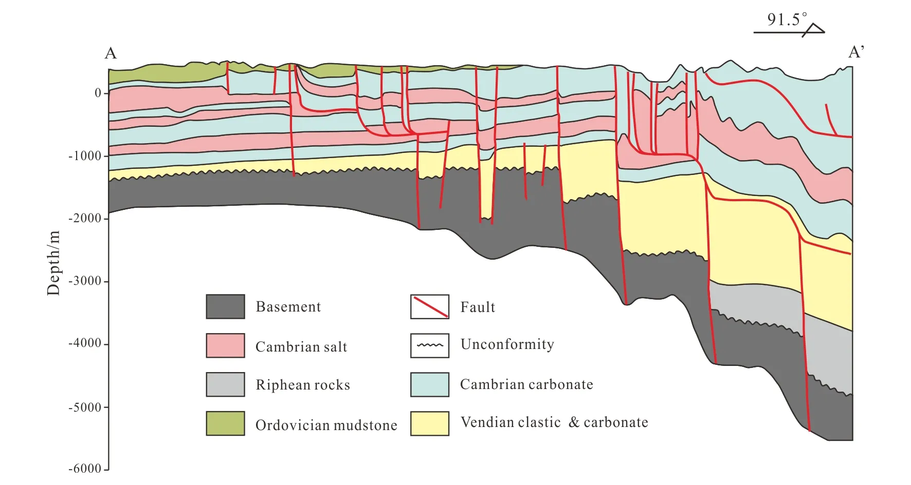
Fig.4 A-A’ profile of Nepa-Botuoba Sub-basin (after IHS, 2008)
The Vendian-Cambrian was main time of first large-scale hydrocarbon migration, and it was also the time that the under-salinastone formed. Compared with the Predpatom Sub-basin, the studied area had a high structural position, and was influenced by the large-scale slope belt resulted from tectonization, the hydrocarbon migrated to the studied area. Moreover, it was affected by compressional force and formation static pressure; the hydrocarbon migrated toward the Nepa-Botuoba Sub-basin along the Vendian sandbody and unconformity plane. The large-scale hydrocarbon accumulation occurred in the trap in the southeast of uplift structural axis and “fossil-reservoir” formed, providing material basis for heavy oil accumulation in the middle of the studied area.
Since the Devonian, because of massive compression, the northern area of the Predpatom Sub-basin was thrust over the studied area, and the drape was uplifted again. Under strong compression, the formation was distorted, forming massive faulted belts. The previous fluid balance in formation was destroyed by extremely high pressure resulted from strong deformation of formation, and secondary large-scale migration of hydrocarbon started. Inside the studied area, the deformation of formation sheltered the lateral migration of hydrocarbon, and the under-salinastone "fossil-reservoir" destroyed by fault was mainly migrated up along fault. Meanwhile, the migration of oil and gas, affected by compressional force, was directed to southern slope of studied area and across fault in the Predpatom area.
4 Favorable exploration direction
It is believed that, based on geological conditions listed above, affected by the Nepa-Botuoba Sub-basin and controlled by distribution of "fossil-reservoir", the favorable exploration area of heavy oil was distri-buted in the southeast side of trend of uplift axial, mainly in core of uplift, the fault zone cutting the under-salinastone reservoir in the south of extensional direction, and the slope zone bordering on the studied area and the Predpatom Sub-basin .
Firstly, since the Vendian, a large amount of hydrocarbon in the Predpatom Sub-basin was expelled and migrated to the Nepa-Botuoba Sub-basin, and it was accumulated in the under-salinastone trap. Following the structural activity after the Devonian, the "fossil-reservoir" was uplifted to surface, and hydro-carbon was under oxidation on the ground. Meanwhile, affected by compressional force of formation, the plastic flow occured in salinastone, and the cap rock in the core of slope became thinner, which benefited that the previous hydrocarbon was under water washing and biodegradation, and heavy oil formed.
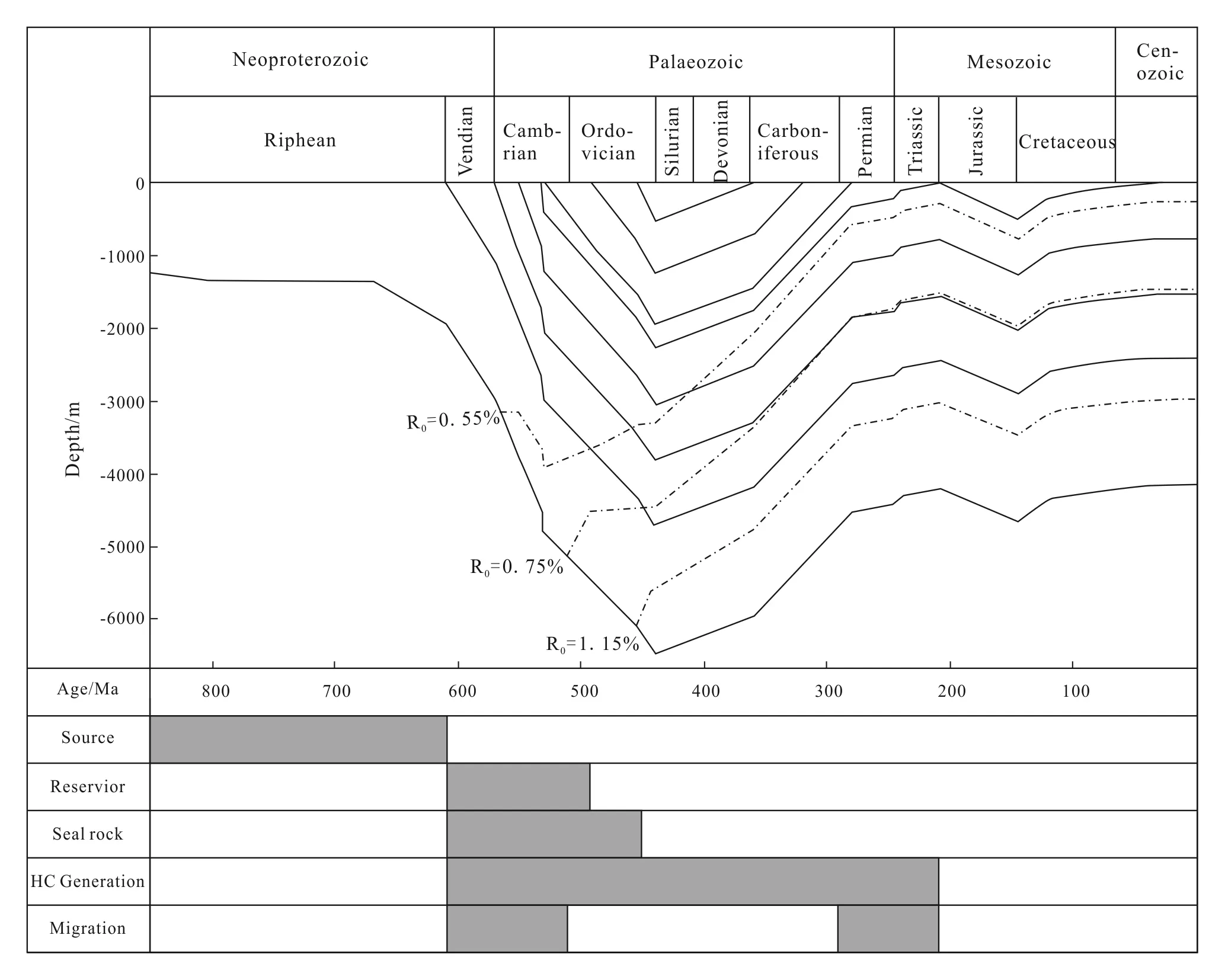
Fig.5 Curve of burial history and petroleum system (after IHS, 2008; Tellus, 2009)
Secondarily, the promising area of heavy oil in fault zone was mainly controlled by distribution of previous "fossil-reservoir". Since the Devonian, massive faults formed in the studied area because of compression and deformation of formation, and it had deep cutting depth and connected the under-salinastone reservoir and upper-salinastone formation, which provided favorable channel for secondary large-scale hydrocarbon migration. Under the compressional force, the hydrocarbon migrated up along fault. The distribution of fault and upper-salinastone formation and the formed structural-formation trap were favorable for hydrocarbon accumulation, and the hydrocarbon was thickened to heavy oil.
Thirdly, affected by compression force, the hydrocarbon in the Predpatom Sub-basin migrated to south margin of the studied area along unconformity plane and sandstone body and across fault. During long distance migration of hydrocarbon, the light component was loss continuously, and after migrating to shallow formation, the hydrocarbon had a poor cap rock condition and was well connected with atmosphere, which was favorable for hydrocarbon thickening (Faetal., 2012; Shanetal., 2011).
5 Conclusions
(1) The effective source rock was not developed inside the Nepa-Botuoba Sub-basin, but thick high quality source rock was developed in the neighboring Predpatom Sub-basin, which provided abundant hydrocarbon source for outside source accumulation. The favorable reservoir conditions in shallow formation, poor cap rock conditions, upper-salinastone reservoir space, and the inter-salinastone in the uplift position provided accumulation space for heavy oil. The poor cap rock condition was favorable for generation of heavy oil.
(2) Under the structural background, the effective distribution of heavy oil was controlled by two periods of hydrocarbon migration. After first hydrocarbon migration, massive "fossil-reservoir" formed in southeast side of structural axis of uplift zone, and the effective distribution of heavy oil inside studied area was controlled. The secondary hydrocarbon migration was directed to favorable accumulation belt of heavy oil.
(3) When studying the heavy oil in the Nepa-Botuoba Sub-basin, in transverse direction, the key exploration areas of heavy oil are the core of uplift of the Nepa-Botuoba Sub-basin, the fault zone cutting under-salinastone oil and gas reservoir, and slope zone in south margin of the studied area, and in longitudinal direction, the core target zone is the Cambrian carbonatite with shallower burial in the upper part of salinastone and reservoir space around salinastone of core of anticline.
C & C Reservoirs. 2007. Verkhnechona field, East Siberian Basin, Russia. Houston: C & C Company, 1-26.
Dai H M, Huang D, Liu X N,etal. 2008. Characteristics and evaluation of marine source rock in Southwestern Shunan.NaturalGasGeoscience, 19(4):503-508. (in Chinese with English abstract)
Fa G F, Kang Y S, Shang Y N,etal. 2012. Enrichment characteristics and metallogenic model of global oil-sand resources.GlobalGeology, 31(1):120-126. (in Chinese with English abstract)
Gu Y, Shao Z B, Chen Q L,etal. 2007. Oil migration and accumulation pattern in the Tahe oil field.PetroleumGeology&Experiment, 29(3):224-230. (in Chinese with English abstract)
He W T, Shan X L, Chen G B,etal. 2015. Sedimentological study of oil sand reservoir in Lower Devonian Pingyipu Formation of Tianjing Mountain, northwestern Sichuan.GlobalGeology, 34(3):726-734. (in Chinese with English abstract)
IHS. 2008. Information handling services. http://www.ihs.com/index.aspx
Ma F, Zhang Y G, Wang H J,etal. 2015. Potential, distribution and exploration trend of global heavy oil and oil sand resources.JournalofJilinUniversity: Earth Science Edition, 45(4):1042-1051. (in Chinese with English abstract)
Mel’nikov N V, Filiptsov Y A, Valchak V I,etal. 2008. Petroleum potential of the Riphean-Vendian Chunya sedimentary basin in the western Siberian Platform.RussianGeology&Geophysics,49(3):176-182.
Shan X L, Zhang J F, Luo H H. 2011. Reservoir forming condition and model of P. R. spring of Eocene oil sand in Uinta Basin.GlobalGeology, 30(2):224-230. (in Chinese with English abstract)
Tao G Q. 2012. Analysis of laws of hydrocarbon accumulation of Riphean-Cambrian in Siberian Platform: master’s degree thesis. Changchun: Jilin University. (in Chinese with English abstract)
Tellus. 2009. Tellus_Data, TM000000607.pdf. New York: Fugro Roberston Limited.
Xu H L, Shan X L, Gao X,etal. 2014. Heavy oil accumulation condition and enrichment regularity of Senegal Basin in West Africa.ScienceTechnologyandEngineering, 14(16): 211-215. (in Chinese with English abstract)
Yang H, Gu W W, Li W. 2006. Status & prospect of development & utilization of world heavy oil resources.ChinaForeignEnergy, 11(6):10-14. (in Chinese with English abstract)
Zhu W L, Wang Z X, Gong S B,etal. 2012. Petroliferous Basins in Russia. Beijing: Science Press, 1-412. (in Chinese)
20 February 2016, accepted 30 March 2016
Supported by National Science and Technology Major Project (2011ZX05028-002); The Science and Technology Major Project of PetroChina Company Limited (2012E-0501).
(E-mail: shanxl@jlu.edu.cn)
Article ID: 1673-9736(2016)03-0125-08
杂志排行
Global Geology的其它文章
- Songjianghe biotite monzonitic granite zircon U-Pb geochronology and geochemical significance
- Mechanism of spatial emplacement of Shanhou gold ore body in Laixi of Shandong and its prospecting significance
- Geochronology, geochemistry and Hf isotope of monzogranite in Niubiziliang of Qinghai
- Geochemical characteristics and petrogenesis of volcanic rocks from Baiyingaolao Formation in northeastern Hailar Basin
- Experimental study of seepage characteristics of single rock fracture based on stress states and stress history
- Experimental study on simulation test instrument and its penetration performance of soil infiltration clogging
