Discussion on Gorkha Earthquake in Nepal
2016-08-01SubinDesarLiJianlinDengHuafengSunXushuLiJianglong
Subin Desar Li Jianlin Deng Huafeng Sun Xushu Li Jianglong
(1. Key Laboratory of Geological Hazards on Three Gorges Reservoir Area, China Three Gorges Univ., Yichang 443002, China; 2. College of Hydraulic & Environmental Engineering, China Three Gorges Univ., Yichang 443002, China)
Discussion on Gorkha Earthquake in Nepal
Subin Desar1Li Jianlin1Deng Huafeng1Sun Xushu1Li Jianglong2
(1. Key Laboratory of Geological Hazards on Three Gorges Reservoir Area, China Three Gorges Univ., Yichang 443002, China; 2. College of Hydraulic & Environmental Engineering, China Three Gorges Univ., Yichang 443002, China)
Abstract:Nepal is an inland country of frequent occurrence for earthquake. The historical records indicated that strong earthquakes occurred once in 80 years round the region. A devastating Mw8.1 earthquake happened on April 25, 2015, at Gorkha, which caused heavy casualties and huge economic losses. After earthquake, the author conducted a two months field research in the earthquake affected area and collected a large number of seismic materials. The study indicated that it is necessary to enhance the seismic protection function of buildings and raise public awareness of earthquake, which can effectively reduce the casualties and economic losses. One of the most critical problems is that a lot design and construction of public buildings in Nepal are not in accordance with the National Building Code (NBC). It is necessary to implement NBC, earthquake resistance and relief specification strictly in the Nepalese public construction.
Keywords:Gorkha earthquake;aftershocks;buildings damages
1Introduction
Nepal is a beautiful inland country located between China and India (Fig 1), with a total territorial area of 147 181 km2and a total population of 26,494,504 (2011)[1].It lies in the earthquake fault along Indian and Eurasian Plates. A total of 92 active faults have been mapped throughout the country by the Seismic Hazard Mapping and Risk Assessment[2]. Hence it is a seismically active country and ranked as 11th seismically vulnerable country in the world[3]. Geophysicists had warned for decades that Nepal was vulnerable to deadly earthquakes.

Fig 1 Location of Nepal[1]
Historical earthquake records of Nepal (Table 1) indicated that strong earthquakes had occurred
around once in 80 years. Gorkha earthquake is the continuation of this trend.Gorkha is located at 28.289 976°N, 84.689 75°E (Fig 2).
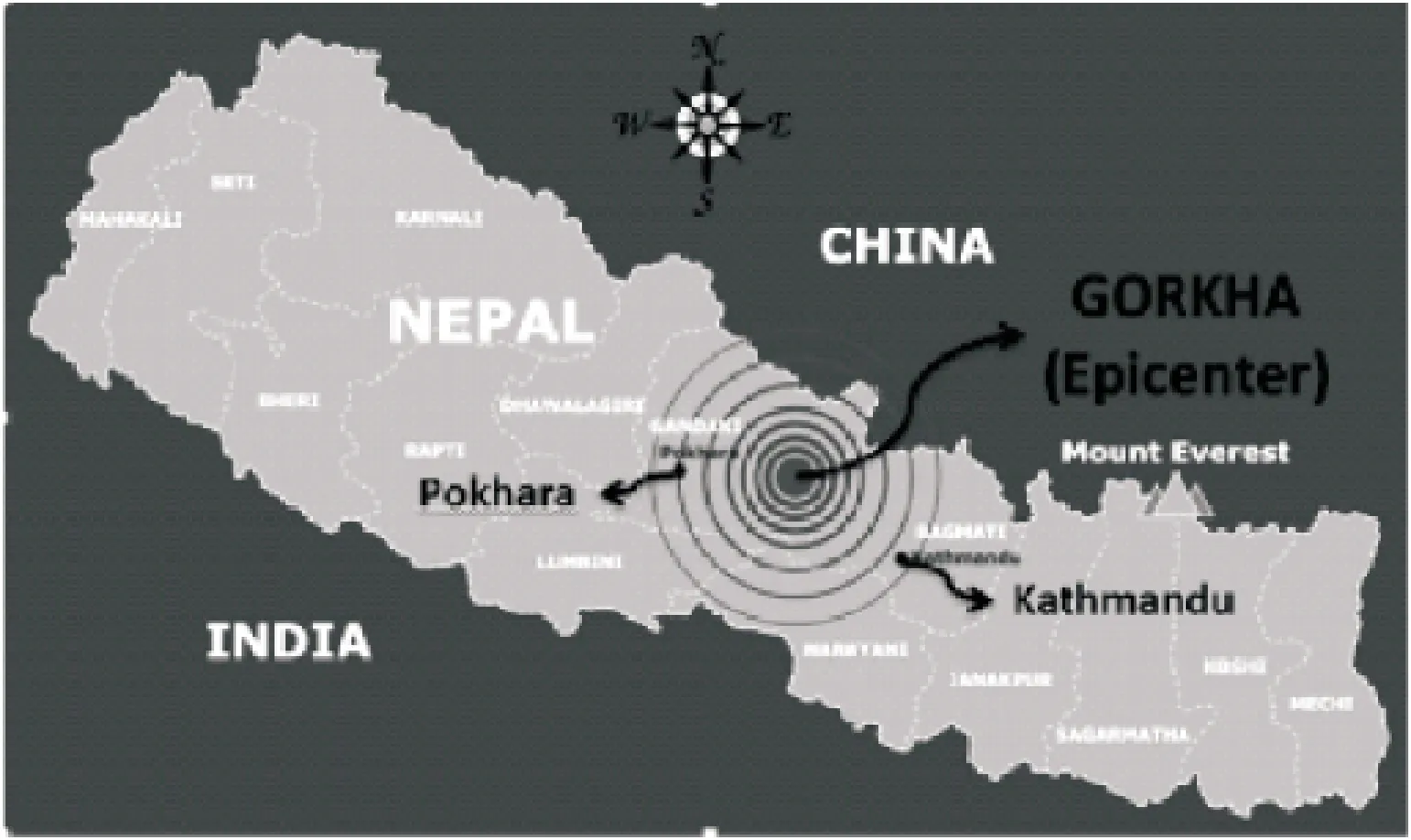
Fig 2 Location of Gorkha district in Nepal
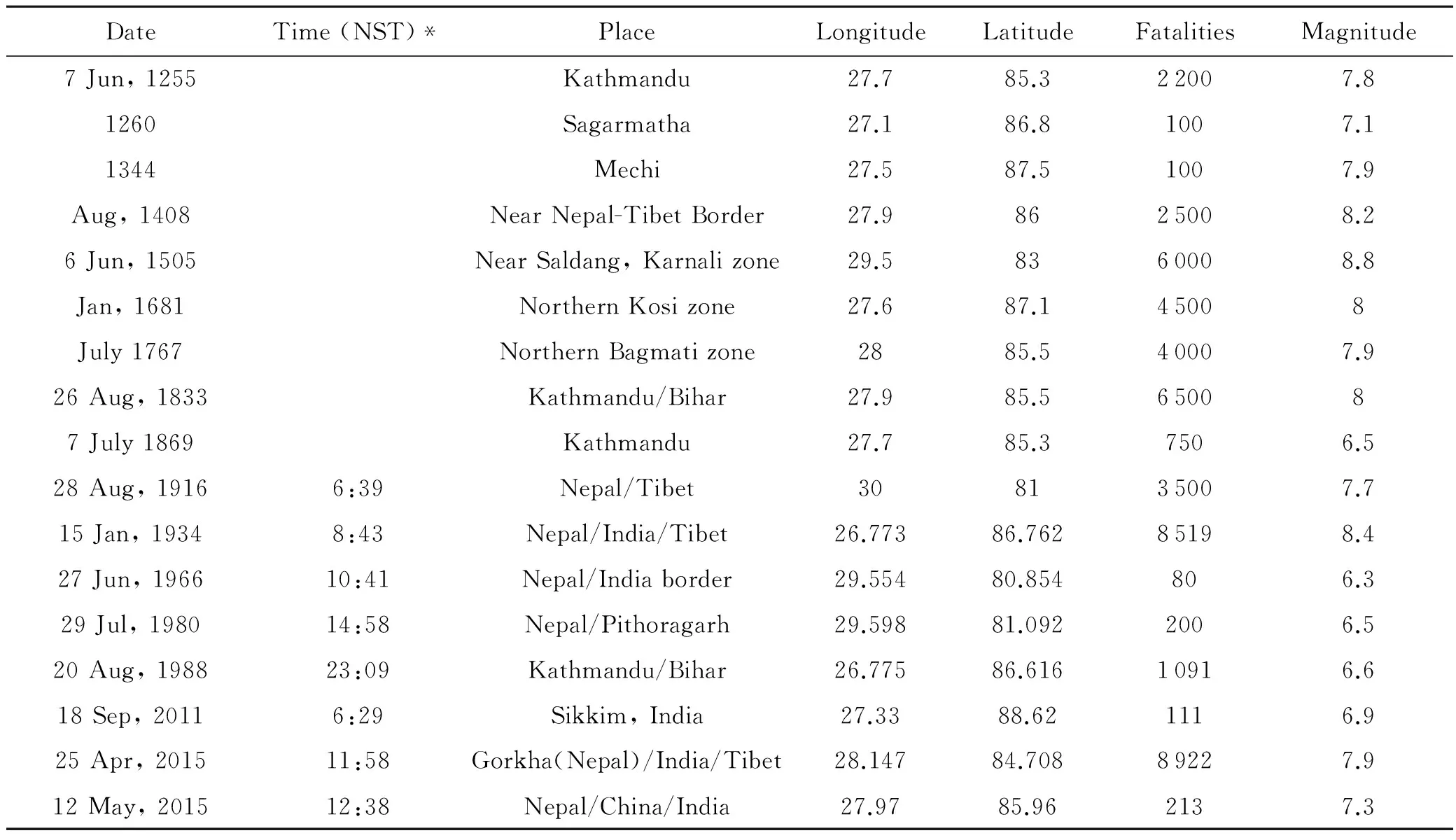
DateTime(NST)*PlaceLongitudeLatitudeFatalitiesMagnitude7Jun,1255Kathmandu27.785.322007.81260Sagarmatha27.186.81007.11344Mechi27.587.51007.9Aug,1408NearNepal-TibetBorder27.98625008.26Jun,1505NearSaldang,Karnalizone29.58360008.8Jan,1681NorthernKosizone27.687.145008July1767NorthernBagmatizone2885.540007.926Aug,1833Kathmandu/Bihar27.985.5650087July1869Kathmandu27.785.37506.528Aug,19166:39Nepal/Tibet308135007.715Jan,19348:43Nepal/India/Tibet26.77386.76285198.427Jun,196610:41Nepal/Indiaborder29.55480.854806.329Jul,198014:58Nepal/Pithoragarh29.59881.0922006.520Aug,198823:09Kathmandu/Bihar26.77586.61610916.618Sep,20116:29Sikkim,India27.3388.621116.925Apr,201511:58Gorkha(Nepal)/India/Tibet28.14784.70889227.912May,201512:38Nepal/China/India27.9785.962137.3
* NST : Nepal Standard Time
According to National Seismological Center of Gorkha Nepal, the earthquake was of magnitude Mw7.9 Richter Scale. United States Geological Survey (USGS) announced it as Mw7.9. Moment Magnitude Scale and China Earthquake Network Center stated it as v8.1 surface wave magnitude[5]. Soon after April 25, another earthquake of Mw7.5 occurred on May 12[6], and then 11 time of Mw5.0-Mw7.5 earthquakes occurred continually (See Tab.2). All of these were aftershocks of April 25 main earthquake, and located in the same fracture zone. This was owing to the huge energy of main earthquake released. Earthquake measurement process is complex, depending upon the procedure of the measurement; the measurement is different, the magnitude may also be different. The prevailing technologies are still inadequate to predict the exact time of earthquake, though some approximate probabilistic and deterministic approaches are adopted to predict the return period, yet it is rather difficult. The most accepted theory to explain the occurrence of natural earthquake is the theory of “Plate Tectonics”.
2Plate Tectonics and Geological Condition of Nepal
The rigid outermost shell of the earth-lithosphere (the crust and upper mantle), is broken up into tectonic plates. The Earth's lithosphere is composed of 7-8 major plates (depending on how they are defined) and many minor plates (Fig 3). Earthquakes, volcanic activity, mountain-building, and oceanic trench formation occur along these plate boundaries. The lateral relative movement of the plates typically ranges from 0-100 mm annually. Plate movement is driven by a combination of the seafloor with downward suction at the sub-ducting zones. Another explanation lies in the different forces generated by tidal forces of the Sun and Moon. The importance of these factors and their relationship is unclear, and still the subject of much debate[7].
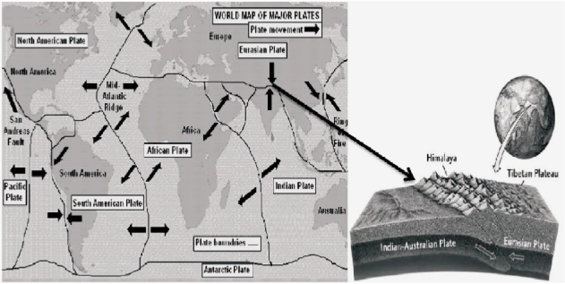
Fig 3 Plates movements (left) and formation of Himalayas due to plate convergence (right)
Geographically Nepal lies on the boundary of two major plates-Indian and Eurasian Plates. The Indian tectonic plate moving north at about 45 mm a year is pushing under the Eurasian plate beneath the Himalayas, causing the Himalayas to rise over time. This is why the world's highest mountain Mt. Everest and other high mountains were formed in this region. As the Indian plate pushes Asia, it produces strong stress and pressure at the point where the two landmasses meet. When that pressure becomes too strong, one landmass slides under another, releasing a shockwave and causing the earthquakes in Nepal[8].
This plate convergence has a significant impact on the entire geological structure patterns in Asia. In addition, it may cause China-Nepal mountain border unstable.
3Time-History of Gorkha Earthquake
Pacific Earthquake Engineering Research (PEER) Center had processed strong motion records for the main shock of the Gorkha Earthquake. Fig 4 shows the time-history recorded on the fifth floor of a 7-story tall reinforced concrete frame building located in Kathmandu, Nepal, at a site about 2000 feet from the KATNP (USGS) station.
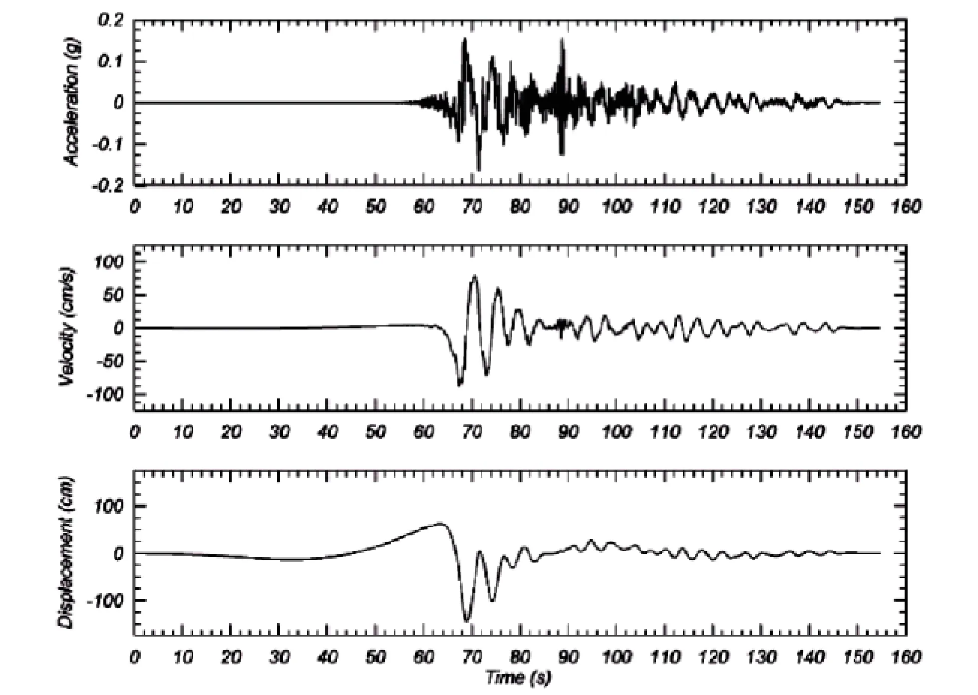
Fig 4 Time-history records of Gorkha Earthquake from KNTNP (USGS) station[9]
The station building suffered no structural damage-observed damage included very minor cosmetic damage to in-filled walls, and damage to localized suspended ceilings on the top floor. Typical column spacing was approximately 16 feet on-center with masonry in-fill walls around the perimeter.
4Soil Condition in Kathmandu
The Kathmandu city is located in a broad valley surrounded by the Himalayas and hills. This valley was formerly the site of a lake within which river delta and lake sediment accumulated to the thickness of about 100 meters. As Kathmandu is built in a basin underlain by lake sediment, it is particularly vulnerable during this earthquake. Maximum fault displacement is about 3 m in the rupture zone, at 20 km north of Kathmandu during Gorkha Earthquake[10].
5Aftershocks of Gorkha Earthquake
The aftershocks that occurred after the Gorkha earthquake see Tab. 2. There had been some seismic activity in the Jumla district before the main shock. However, they were not foreshocks to the main shock. Until June 7 2015, over 304 aftershocks occurred. The large number of aftershocks after the big earthquake is considered normal by seismologists.
Gorkha Earthquake and Aftershocks are shown as Tab.2.
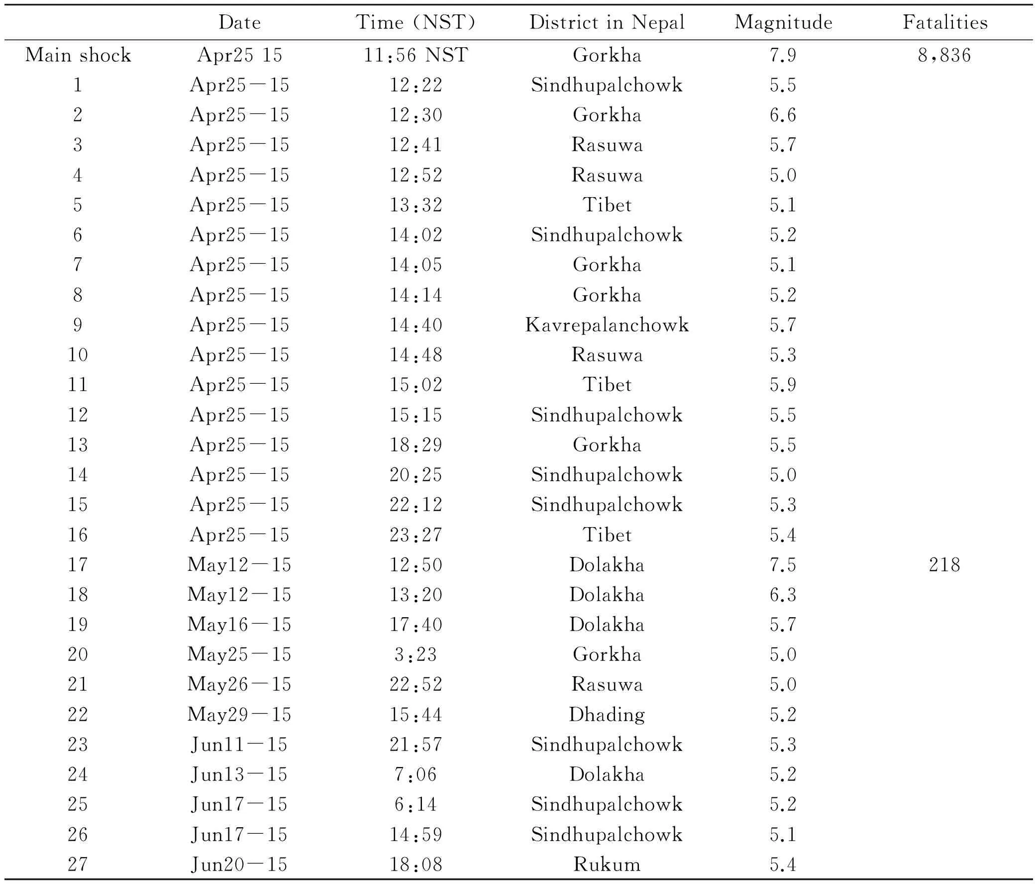
Table 2 Gorkha Earthquake and Aftershocks[11](Mw≥5.0)
6Damage to the buildings
6.1Damages due to the foundation settlement
During the study, we found that although not properly designed, most of the reinforced concrete (RC) buildings had born the earthquake. However, in some areas at Samakushi and nearby Kathmandu valley reinforced concrete buildings had been damaged due to foundation settlement (Fig 5). The bearing capacity of soil in the areas is lower.
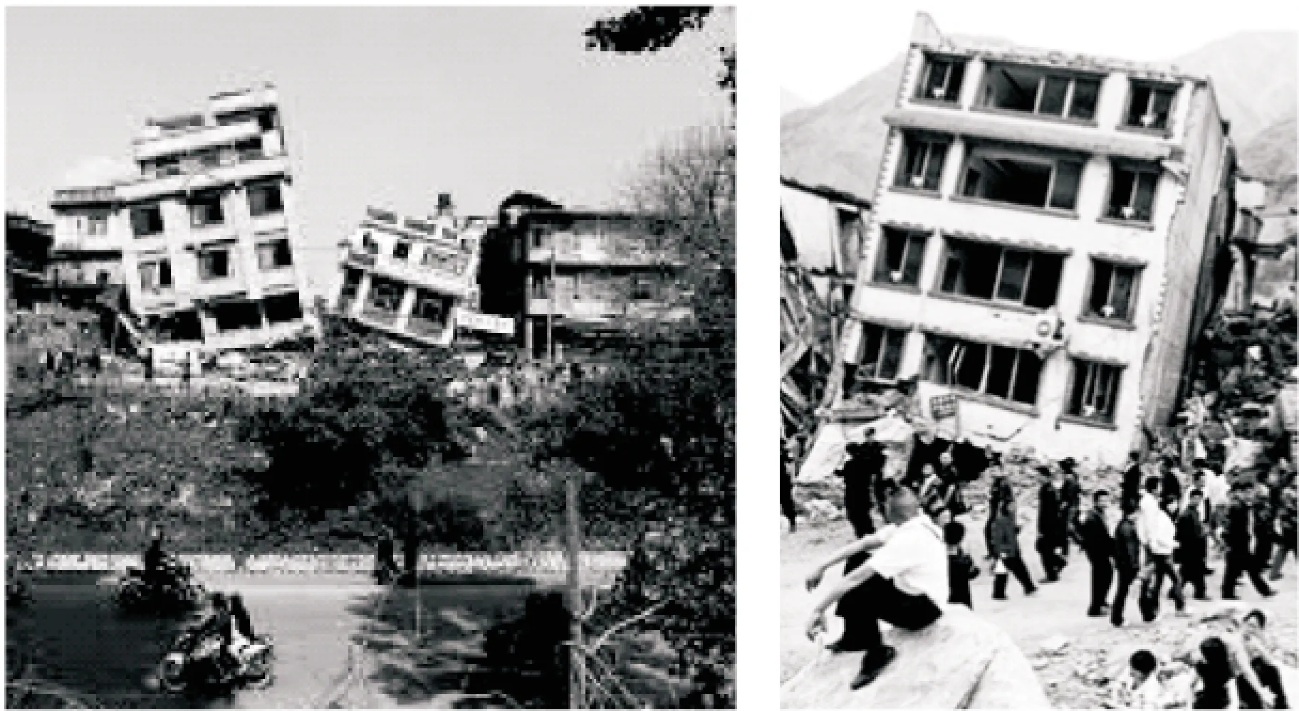
Fig 5 Buildings collapsed due to foundation settlement in Samakushi area
Although the upper structure was strong enough to withstand the earthquake, the lower structure was not properly designed, which led the foundation settlement and caused whole structure collapse.
6.2Damage due to communication towers on building
Usually, houses in Nepal are not built for communication tower loads. The towers are not only higher but also need heavy batteries for good signal transmission. For the erection of such towers, higher buildings are chosen for most customers could access the signal.
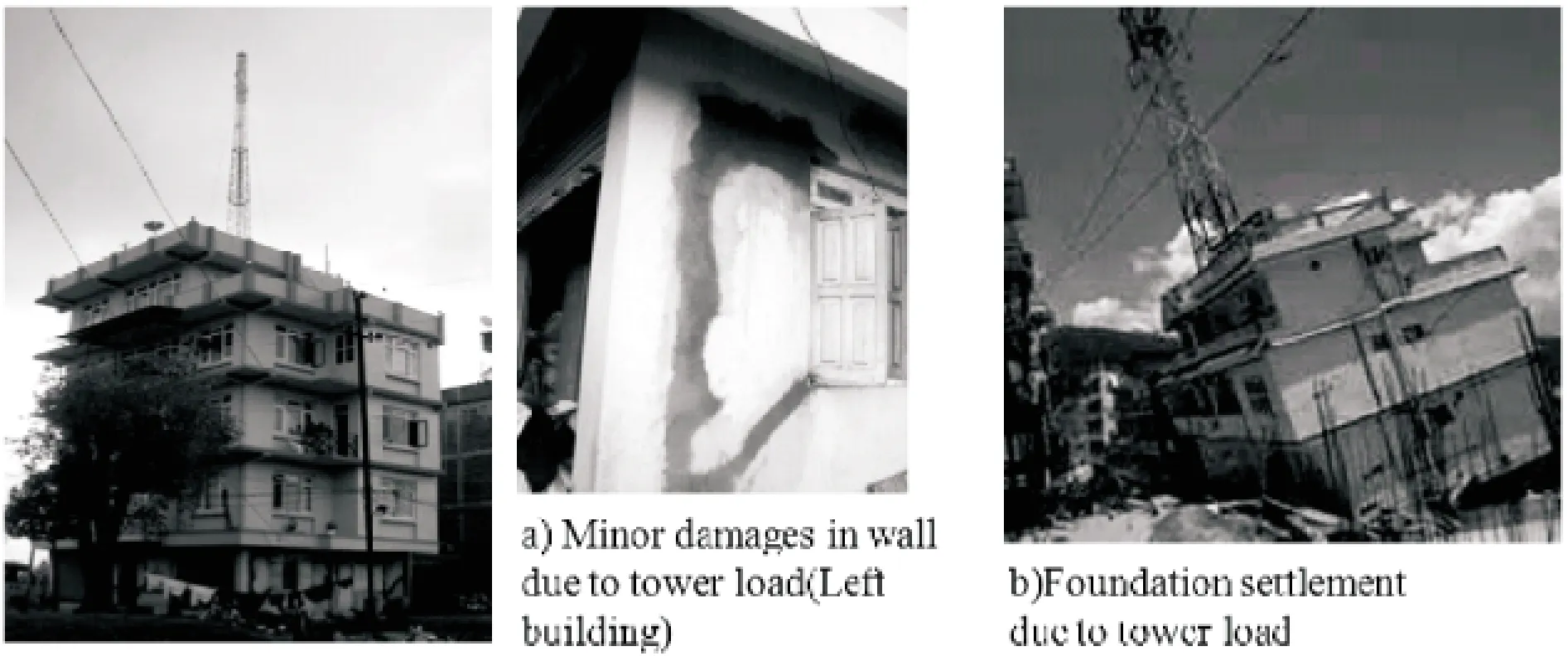
Fig 6 Buildings damaged due to tower load in Lalitpur
Most houses when building was higher were selected by the tower company in Nepal. It means the buildings with tower are not designed for the moments and shear forces induced by tower and its batteries. Hence most of the houses with tower were damaged during the earthquake (Fig 6).
6.3Damage due to weak mud mortar
Almost all mud mortar houses were not suitable for use after the earthquake in Kathmandu (Fig 7). All of the mud mortar houses near the epicenter were completely grounded.

Fig 7 Damages due to weak mud mortar in Lalitpur
Some of the mud mortar houses seemed unaffected when inspected from the outside, yet they were unsuitable for use when inspected from inside.
6.4Damages in apartment
Before Gorkha earthquake, the apartment business was slowly flourishing in Nepal but the earthquake proved a nightmare for the business. From the visual inspection, Nepal Government declared that 11 out of 16 apartments in the Kathmandu valley were unsafe.
Most of structural designer concentrates on main structural components, but paid less emphasis to the walls. Hence most of the apartments seemed very vulnerable from outward (Fig 8), almost all the walls were severely damaged need to repair.
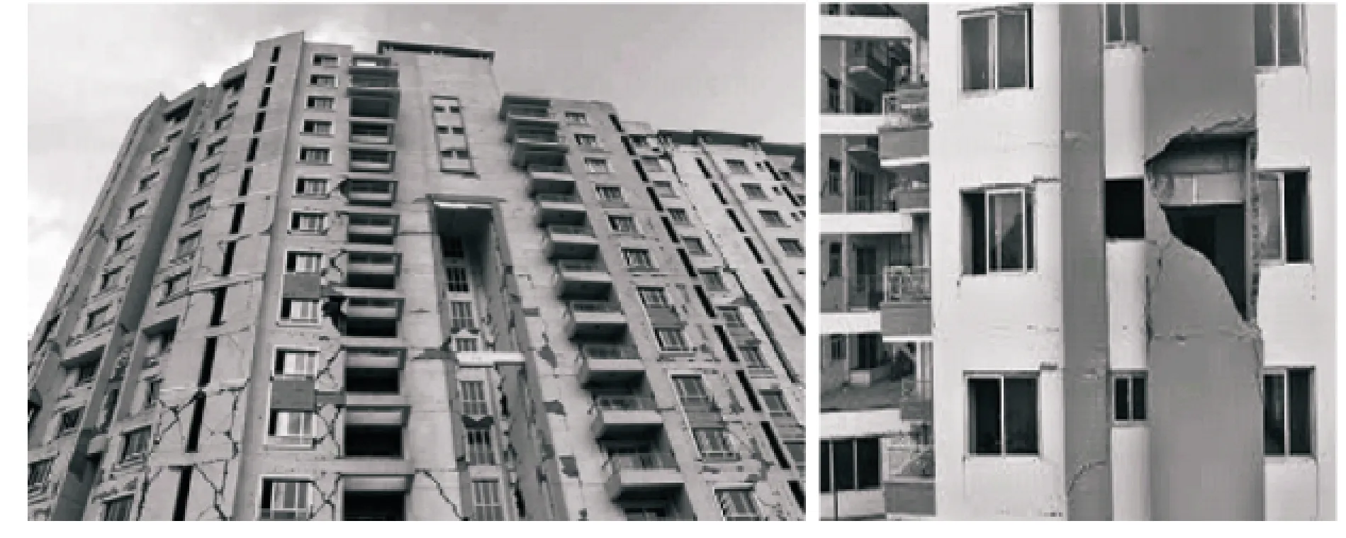
Fig 8 Damages in apartment walls in Kathmandu valley
6.5Damages due to weak neighbor buildings
In many cases, the buildings were damaged by the collapse of nearby weak buildings. The cracked materials falling from high buildings are dangerous to the nearby small buildings. One typical damage mode due to adjoining building is shown in Fig 9.
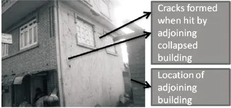
Fig 9 Damages due to adjoining building in Lalitpur
Hence high rise apartments were also one of the greatest threats to the nearby residential buildings.
6.6Miscellaneous damage modes of building
Complex structures are common in Nepal, contain RC structure in one floor and masonry structure in another. Structural analysis indicated that the complex structures led high load concentration in particular area and induced the structure to failure. Almost all the complex structures in Kathmandu and near the epicenter were damaged during the earthquake. Most of the roof-top water tanks placed above two columns were also failed. There were other different damage modes of the building like soft story action, mass irregularity, vertical irregularity etc.
7Damages in historical monuments
7.1Collapse of historical tower (Dharahara)
The highest historical tower (Dharahara) in Nepal was collapsed in 2015 Gorkha earthquake. It was a nine-story, 61.88 m high (203.0 ft) tower at the center of Sundhara in Kathmandu and was a part of the architecture of Kathmandu recognized by UNESCO[12].
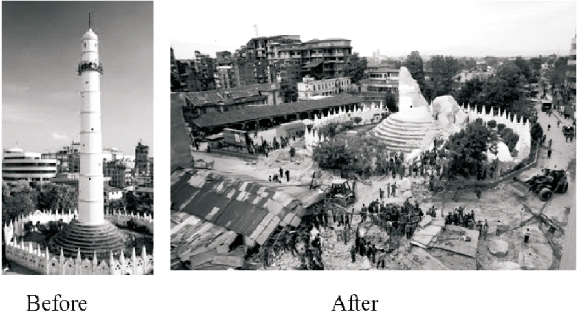
Fig 10 Dharahara before and after collapse
7.2Damage of other heritages
Centuries-old buildings were destroyed at UNESCO World Heritage sites in the Kathmandu Valley, including some at the Kathmandu Durbar Square, the Patan Durbar Square, the Bhaktapur Durbar Square, the Changu Narayan Temple and the Swayambhunath Stupa.
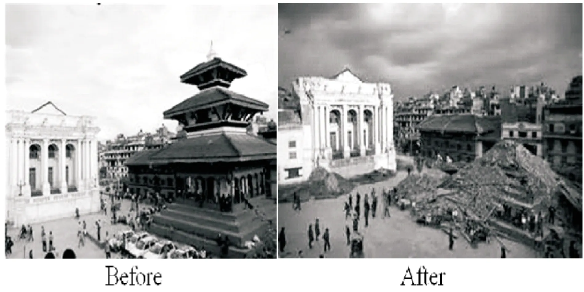
Fig 11 Bashantapur Durbar Square Before and After Collapse in Kathmandu
8Affected Area and Miscellaneous Damages
The worst affected districts were Bhaktapur, Dhading, Dolakha, Gorkha, Kathmandu, Lalitpur, Lamjung, Rasuwa, Ramechhap, Nuwakot, Sindhupalchok, Makawanpur, and Sindhuli. Initial estimates based on Government data suggested that around 980,000 people were directly affected in the 13 most impacted districts as a result of their houses being collapsed or significantly damaged[13].
Almost all civil engineering works were affected including highways, hydropower projects etc. Two major highways, Arniko Highway and Prithivi Highway were completely blocked due to earthquake inducing landslide. At least 14 hydropower stations were damaged. But they are not under the scope of this study.
9Codes requirements and general practice
Nepal has its own technical standards for the construction works, such as NBC 105:1994[14]. The maximum value of basic seismic coefficient is 0.08. The buildings constructed according to the code were not only safe, but also no any cracks. Hence the code is adequate for earthquake resistant buildings in Nepal. All of the damage was owing to lack of the standard code implementation in construction.
Some International Government Organizations (INGOs) and National Government Organizations (NGOs) are working in collaboration with Department of Urban Development and Building Constructions (DUDBC) of Nepal. The efforts are being made to convey the engineering construction to local masons but are still inadequate. Great majorities of villages haven't yet reached the INGOs, NGOs and government.
10Conclusion and Recommendation
The earthquake coefficient adopted for the building design in the NBC of Nepal is adequate, so building codes should be strictly applied in construction. Soil and foundation test must be done before structural design. Non-structural components like infill wall must be designed for earthquake resistance. There is compulsion for structural design in urban area in Nepal but supervision during the construction is not strict. Normal practice was that structural design was done just for the government registration. Most of the buildings were built without the supervision of engineers. There is also the practice to add floors for renting in buildings without proper structural design in the urban area, although law does not permit it. In village area there is no any supervision during building construction. In case of apartments attention is not paid well for infill walls.Such practices should be strictly checked by concerned authorities.
Besides, proper authorities should be assigned for special masons training all over the country, so the Mandatory Thumb Rules (MRT) could be applied in construction.
Acknowledgements: Sincerely thanks to the Dean of International Relations Department in CTGU, Mr. Jian Xi for providing me a valuable suggestion in amendment of the thesis writing. Again, sincerely thank my GOD for providing me such a wonderful work!
References:
[1]Map of the world,Nepal Map, Where Nepal is[EB/OL]. http://www.mapsofworld.com/nepal/nepal-location-map.html.
[2]NSET[EB/OL]. http://www.nset.org.np/nset2012/index.php/menus/menuid-58/submenuid-137.
[3]Rameshwor Dangal, 2015, Country Profile: Nepal, Disaster Risk Management: Policies and Practices in Nepal.
[4]The free Encyclopedia, List of earthquakes in Nepal[EB/OL]. http://en.wikipedia.org/wiki/List_of_earthquakes_in_Nepal.
[5]Wikipedia, the free encyclopedia, April 2015 Nepal Earthquake[EB/OL]. http://en.wikipedia.org/wiki/April_2015_Nepal_earthquake.
[6]Wikipedia, the free Encyclopedia, List of earthquakes in Nepal[EB/OL]. http://en.wikipedia.org/wiki/List_of_earthquakes_in_Nepal.
[7]Plate tectonics[EB/OL]. http://en.wikipedia.org/wiki/Plate_tectonics.
[8]Alzajeera News[EB/OL].http://www.aljazeera.com/news/2015/04/caused-nepal-earthquake-15042607 5723870.html.
[9]Pacific Earthquake Engineering Research (PEER) Center[EB/OL]. http://peer.berkeley.edu/news/2015/05/gorkha-nepal-earthquake-peer-strong-motion-records-server-room-video/.
[10] IRIS, Teachable Moments, Magnitude 7.8, Saturday April 25, 2015 at 06:11:26 UTC.
[11] Wikipedia, List of aftershocks of April 2015 Nepal earthquake[EB/OL]. http://en.wikipedia.org/wiki/List_of_aftershocks_of_April_2015_Nepal_earthquake#List_of_aftershocks.
[12] Wikipedia, the free encyclopedia, Dharahara[EB/OL]. http://en.wikipedia.org/wiki/Dharahara.
[13] OSOCC Assessment Cell, 2015. Situation Analysis Nepal Earthquake[R]. On-Site Operations Coordination Centre (OSOCC), United Nations Disaster Assessment and Coordination (UNDAC).
[14] National Building Code, NBC 105:1994. Seismic Designs of Buildings in Nepal.
[责任编辑王康平]
收稿日期:2016-02-18
通信作者:李建林(1961-),男,教授,博士生导师,主要研究方向为岩土卸荷力学.E-mail:subin@ctgu.edu.cn
DOI:10.13393/j.cnki.issn.1672-948X.2016.02.009
中图分类号:P316
文献标识码:A
文章编号:1672-948X(2016)02-0037-07
对尼泊尔廓尔喀地区地震的探讨
Subin Desar1李建林1邓华锋1孙旭曙1李江龙2
(1. 三峡大学 三峡库区地质灾害重点实验室, 湖北 宜昌443002; 2. 三峡大学 水利与环境工程学院, 湖北 宜昌443002)
摘要尼泊尔是一个地震多发的内陆国家,地震统计资料指出,每隔80年左右将发生一次强震.2015年4月25日,尼泊尔廓尔喀地区发生Mw 8.1级毁灭性的地震灾害,带来严重的人员伤亡和巨大的经济损失.地震发生后,作者深入地震灾区进行两个多月的现场调研,收集大量的现场地震资料.研究表明,增强建筑物的抗震性能和提高民众对地震的防范意识是非常必要的,可以有效地减少地震带来的人员伤亡和经济损失.其中,一个关键问题就是尼泊尔的很多公共建筑物在设计施工过程中,没有严格执行国家建筑规范.因此,在今后尼泊尔的公共建设中,必须严格执行国家建筑及抗震救灾规范.
关键词廓尔喀地震;余震;建筑物破坏
