松花江流域不同空间尺度典型流域泥沙输移比及其影响因素
2016-06-18高燕张延玲焦剑谢云
高燕,张延玲,焦剑,谢云
(1.水利部松辽水利委员会,130021,长春;2.中国水利水电科学研究院,100048,北京;3.北京师范大学地理学与遥感科学学院,100875,北京)
松花江流域不同空间尺度典型流域泥沙输移比及其影响因素
高燕1,张延玲1,焦剑2†,谢云3
(1.水利部松辽水利委员会,130021,长春;2.中国水利水电科学研究院,100048,北京;3.北京师范大学地理学与遥感科学学院,100875,北京)
摘要:为在不同空间尺度上对东北黑土区流域侵蚀产沙建立宏观认识,以松花江流域为研究区,选择不同尺度的典型流域,通过收集降水、遥感影像和土地利用资料,计算不同尺度流域土壤流失量;采用流域出口量水堰和水文站径流泥沙观测资料,计算流域输沙量,从而得出不同空间尺度典型流域悬移质泥沙输移比(SDR)。研究区小尺度流域全年SDR为0.33,大中尺度流域SDR变化于0.005~0.365之间,平均仅0.051。本区SDR存在显著的季节差异:小尺度流域雨季SDR为0.38,春季融雪侵蚀期仅为0.17;流域面积(A)和主河道比降(SLP)是影响大中尺度流域SDR的重要因素;SDR与A呈幂函数递减关系,这在丘陵漫岗区更为显著;山区的流域的SDR随SLP的增加而递增。研究成果有助于建立本区土壤侵蚀与流域产沙之间的定量关系,为流域水土保持规划提供科学依据。
关键词:泥沙输移比; 土壤流失量; 输沙量; 流域面积; 主河道比降; 黑土区; 松花江流域
泥沙输移比是流域侵蚀产沙研究中的基础问题。泥沙输移比为流域出口控制断面的输沙量与控制断面以上流域土壤流失总量的比值,是在不同空间尺度上建立产沙量和侵蚀量之间联系的定量因子[1-2]。其中,流域输沙量可以通过在出口设置水文站或量水堰,进行水文观测获得;而作为推算泥沙输移比的重要环节,流域土壤流失量的计算是制约流域泥沙输移比计算精度的重要因素。
计算土壤流失量方法较多,总体而言可分为实地测量调查、模型计算和遥感调查等3大类。对于面积较大的区域,实地测量调查工作量十分巨大,结合遥感图像信息,利用土壤侵蚀模型计算土壤流失量是相对简便可行的方法[3]。在建模方法上,主要通过因果分析和统计分析,确定影响土壤侵蚀的主要因素,进而建立计算土壤流失量方程式[4-5]。
东北地区是我国重要的商品粮基地;然而,人类的长期不合理开发使得该地区水土流失日益严重,已对粮食安全构成严重威胁[6]。现有研究表明,东北黑土区坡面侵蚀面积大,河道输沙量小是本区侵蚀产沙的鲜明特点之一[7]。由于目前尚不清楚流域尺度内侵蚀物质发生堆积的区域和条件,现有研究不能有效建立坡面侵蚀和流域产沙之间的定量联系;因此,开展东北黑土区泥沙输移比的研究,在不同空间尺度上对流域侵蚀产沙建立宏观认识,可为该区水土流失综合治理提供重要科学依据。笔者以东北黑土区的松花江流域为研究区,选择不同尺度的典型流域,通过收集降水、遥感影像和土地利用资料,计算土壤流失量,采用流域出口量水堰和水文站径流泥沙观测资料,计算流域输沙量,得出不同空间尺度典型流域泥沙输移比,以建立本区土壤侵蚀与流域产沙之间的定量关系。
1研究区概况
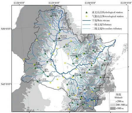
图1 气象站和水文站分布Fig.1 Distribution of meteorological stations and hydrological stations
松花江流域三面环山,西部和北部为大兴安岭和小兴安岭(合称兴安岭山地),流域东部及东南部为完达山脉、老爷岭、张广才岭和长白山脉(合称流域东部山地)。兴安岭山地和流域东部山地自其山前丘陵区和漫川漫岗区向流域中心地带的平原过渡。笔者在松花江干流、第二松花江和嫩江的不同级别支流共选择35个流域(图1)。其中:17个流域主体海拔高度在500 m以上,以山地为主,主河道比降变化介于2‰~5‰之间;18个流域主体海拔高度在200~500 m之间,以丘陵漫川漫岗为主,主河道比降变化介于1‰~2‰之间。鹤北8号流域位于农垦九三分局鹤北流域内,流域面积2.8 km2,地貌类型为丘陵漫岗,坡缓坡长,土地利用以耕地为主,耕地面积占流域总面积的98%。
按空间尺度差异,将研究流域分为小、中、大3类。参考已有的流域尺度类别划分标准[8-9],将面积<100 km2的流域划分为小尺度流域,选择鹤北8号流域作为研究的典型流域,将面积>2 000 km2的流域划分为大尺度流域,100~2 000 km2的流域为中尺度流域。
2材料与方法
2.1资料收集
资料主要有降水资料、地图与遥感资料、水文资料和径流小区产流泥沙资料。降水资料包括36个气象站和35个雨量站自20世纪50年代至2010年底的逐年日降雨数据,用于计算降雨-径流侵蚀力。地图与遥感资料包括东北地区1∶100万土壤类型图和土地利用图、美国航天飞机雷达拓朴测绘数据、小流域坡度遥感数据和土地利用(分辨率30 m×30 m)。其中,土壤类型图用于计算土壤可蚀性,雷达拓朴测绘数据和土地利用图用于提取大中尺度流域地表坡度和土地利用信息,小流域坡度遥感和土地利用数据用于提取小尺度流域地表坡长、坡度和土地利用信息,以计算坡长、坡度因子和水土保持措施因子。
水文资料包括松花江流域35个水文站点(图1)自20世纪50年代至2010年底的逐日降水量、径流量和泥沙含量(悬移质)资料,以及鹤北8号小流域2004—2006年把口径流堰径流泥沙资料,以计算流域输沙量。各水文站资料年限在12~55年之间,平均为28.8年。
径流小区产流泥沙资料为鹤北8号小流域17个径流小区2004—2006年逐次产流的径流量和泥沙量,可用于计算小尺度流域土壤流失量。
2.2土壤流失量计算
2.2.1大中尺度流域土壤流失量计算利用Liu Baoyuan等[10]提出的中国土壤流失预报方程(Chinese Soil Loss Equation,CSLE)计算多年平均土壤流失量
AE=RKLSBET。
(1)
式中:AE为多年平均年土壤流失量,t/(hm2·a);R为降雨-径流侵蚀力,MJ·mm/(hm2·h·a),依据多年平均降水量计算[11];K为土壤可蚀性,t·hm2·h/(hm2·MJ·mm),利用三次样条法[12-13]计算。L和S分别为坡长因子和坡度因子。本文视研究区耕地地表坡长为300 m,其他土地利用类型为100 m,则L值依据刘宝元等[14]提出的典型黑土区坡长因子公式计算;S依据RUSLE[4]和Liu B Y等[15]提出的方法计算:
(2)
B为生物措施因子:耕地B值为大豆和玉米生物措施因子的平均值;疏林地、园地和草地B值依据本区荒山灌木梗小区观测值确定,为0.054[16];水域、居民点、独立工矿地和交通用地B值为0。根据水土流失抽样调查结果,本区有林地的植被覆盖度基本在70%~80%之间,故研究视有林地植被覆盖度为75%,依据用刘秉正等[17]提出的经验公式计算得其B因子值为0.022。E为工程措施因子,取值为1。T为耕作措施因子,取横坡和顺坡种植的耕作措施因子的平均值,为0.441[16],其他土地利用类型T值均为1。
多年平均土壤流失量由上述各因子图层叠加运算获得,网格大小均插值到90 m×90 m。
2.2.2小尺度流域土壤流失量计算流域侵蚀总量为片蚀量、浅沟侵蚀量和切沟侵蚀量之和。其中,片蚀量依据式(1)计算,除L和S因子,其他因子均利用雨季径流小区产流泥沙资料获得,并以网格分辨率为30 m×30 m的精度计算各流域土壤流失量。浅沟侵蚀量依据张永光等[18]观测的浅沟侵蚀量获得;根据Wu Yangqiu等[19]推算,该流域切沟侵蚀量应为浅沟侵蚀量的2.35倍。
2.3流域泥沙输移比计算
各流域的泥沙输移比(SDR)为流域出口控制断面的输沙量与用模型计算的该流域土壤流失总量的比值。流域出口断面输沙量由径流量和径流含沙量获得。本文将分析流域面积(A)、主河道比降(SLP)等下垫面特征对泥沙输移比(SDR)的影响。对于小尺度流域,则分析了不同季节泥沙输移比的差异。由于本区水文测站普遍缺乏推移质观测资料,笔者计算的SDR值为悬移质泥沙输移比。
3结果与分析
3.1小尺度流域泥沙输移比
鹤北8号小流域全年泥沙输移比为0.33,雨季侵蚀产沙过程的泥沙输移比变化介于0.04~0.76之间,平均为0.38。流域地表坡度大多在3°以下,致使汇流速度慢,径流容易入渗;且夏季气温高,蒸发强烈。地表径流在入渗和蒸发的同时,所挟带侵蚀物质会在坡脚、草甸等地势平缓或地表阻力较大处沉积。鹤北8号小流域春季融雪侵蚀期流域泥沙输移比仅为0.17。流域不同季节被输送的泥沙质地有显著差别,融雪侵蚀期大多数泥沙来源于沟蚀和重力侵蚀,侵蚀物质以粗沙为主;降雨侵蚀期大多数泥沙来源于面蚀和细沟侵蚀,侵蚀物质以细沙为主。在泥沙输移过程中,粗沙更易沉积,而细沙更易传输到下游。
3.2大中尺度流域泥沙输移比
本区大中尺度流域泥沙输移比普遍较低,其值变化于0.005~0.365之间,平均仅为0.051,表明大部分侵蚀物质在到达流域出口之前已发生沉积。侵蚀物质的迁移距离和流域地形特征对本区SDR值有显著影响。随着A扩大,侵蚀物质迁移距离相应增加,其发生沉积的可能性相应增加。SDR与A的线性相关并不十分显著,二者呈幂函数递减关系(图2):
SDR=1.25A-0.41
(R2= 0.32,n = 35,P < 0.01)。
(3)
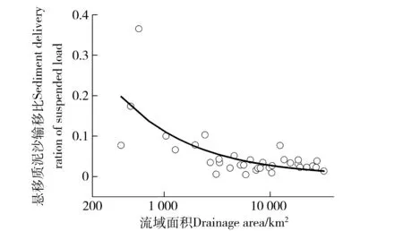
图2 松花江流域悬移质泥沙输移比与流域面积的关系Fig.2 Relationship between sediment delivery ratio of suspended load and drainage area in Songhua River Basin
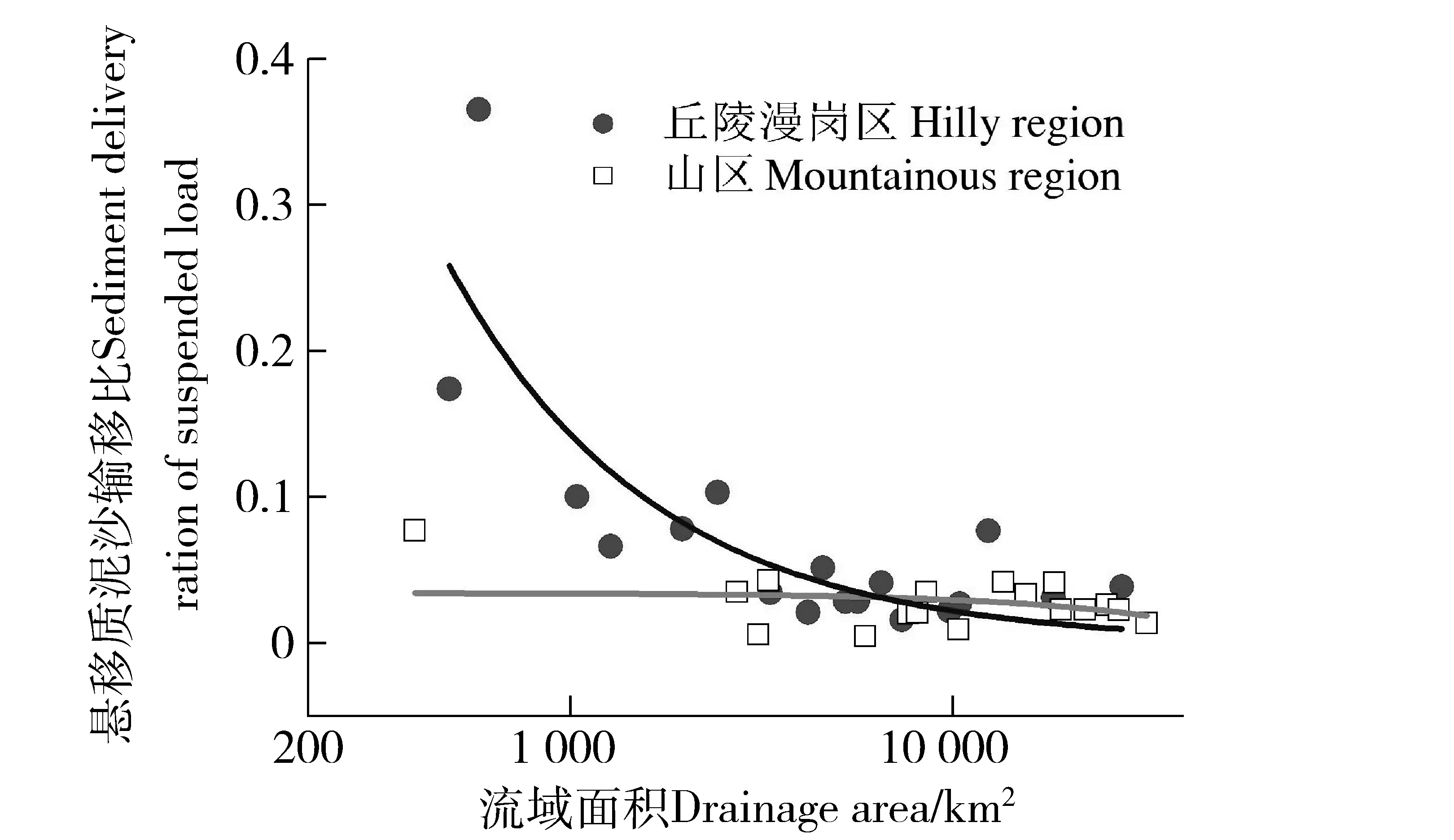
图3 丘陵漫岗区和山区流域悬移质泥沙输移比与 流域面积的关系Fig.3 Relationship between sediment delivery ratio of suspended load and drainage area for the mountainous and hilly regions
在坡缓坡长的丘陵漫岗区,这一关系更为显著(图3):
SDR= 4.01A-0.52
(R2=0.55,n=18,P<0.01)。
(4)
位于山区的流域,其SDR随SLP的增加而递增,表明在地表起伏更为显著,坡度相对较陡的流域,坡面侵蚀产生的泥沙更易被运移至流域出口(图4):
SDR=0.007SLP+0.004
(R2=0.48,n=16,P<0.01)
(5)
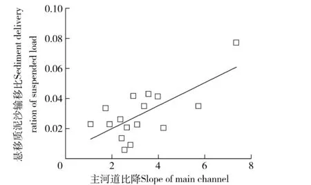
图4 山区流域悬移质泥沙输移比与主河道比降的关系Fig.4 Relationship between sediment delivery ratio of suspended load and the slope for the main channel in mountainous region
3.3东北典型黑土区侵蚀泥沙坡面至河道运移过程
我国黄河流域主要支流SDR值多变化,介于0.5~1.0之间[20-23];长江流域主要支流SDR值多变化,介于0.3~0.7之间[24-27]。与之相比,笔者所计算的各流域泥沙输移比较低。本区侵蚀泥沙自坡面至河道的运移特征可能是影响不同空间尺度SDR值变化的重要原因。
东北典型黑土区地貌以丘陵漫川漫岗为主,坡度一般不大,主要是直线坡和凹形坡,也有一些弱变化的复式坡和不明显的凹坡,从坡顶向下,面蚀起初随坡面径流厚度、流速和携带泥沙量的增大而逐渐增强,至一定距离后,由于泥沙负荷太大,损耗径流冲刷力使面蚀减弱,及至坡脚则代之以堆积[27]。而沟蚀在坡面和谷底均有发育。坡面沟侵蚀主要来源于沟壁崩塌和沟底下切;谷底沟沟头溯源侵蚀湿润年份发育迅速,干旱年份发育基本停滞,在降雨量中等的年份则多出现堆积[28]。
目前,有关东北黑土区主要侵蚀类型特征均有报道,但对流域内泥沙沉积的研究相对较为薄弱。在流域侵蚀产沙观测中,需通过塘库泥沙淤积调查、放射性元素测年等方法[29-30],推算泥沙淤积量。
4结论
1)本区小尺度流域全年泥沙输移比为0.33,即约有2/3之多的侵蚀物质在泥沙输移过程中沉积。随着流域尺度的增大,侵蚀物质在进入河道前发生沉积的机率会进一步增加。本区大中尺度流域泥沙输移比普遍较低,其值变化介于0.005~0.365之间,平均仅为0.051。
2)本区泥沙输移比存在显著的季节差异,这主要由泥沙粒径组成的差异造成。小尺度流域雨季侵蚀产沙过程的泥沙输移比为0.38,春季融雪侵蚀期流域泥沙输移比仅为0.17。融雪侵蚀期绝大多数泥沙来源于沟蚀和重力侵蚀,侵蚀物质以粗沙为主;降雨侵蚀期泥沙多来源于面蚀和细沟侵蚀,侵蚀物质以细沙为主。
3)流域面积(A)和主河道比降(SLP)是影响大中尺度流域泥沙输移比(SDR)的重要因素。SDR与A呈幂函数递减关系,在坡缓坡长的丘陵漫岗区,这一关系更为显著SDR=4.01A-0.52。位于山区的流域,SDR随SLP的增加而递增。
5参考文献
[1]Walling D E. The sediment delivery problem [J]. Journal of Hydrology, 1983, 65(83):209.
[2]Lane L J,Hernandez M,Nichols M. Processing controlling sediment yield from watersheds as functions of spatial scale [J]. Environment Modeling & Software, 1997, 12(4): 355.
[3]Van der Kinff J M, Jones R J A, Montanarella L. Soil erosion risk assessment in Europe[R]. Brussels, Belgium: European Commission, European Soil Bureau, 2000.
[4]Renard K G, Forster G R, Weesies G A, et al. Predicting soil erosion by water: a guide to conservation planning with the revised universal soil loss equation (RUSLE) [M]. Washington D C: US Department of Agriculture, 1997:14-17.
[5]Lu H,Gallant J,Prosser I P, et al. Prediction of sheet and rill erosion over the Australian Continent,incorporating monthly soil loss distribution. CSIRO Land and Water Technical Report 13/01[R]. Canberra, Australia: Commonwealth Scientific and Industrial Research Organization, 2001.
[6]Duan Xingwu, Xie Yun, Feng Yanjie,et al. Study on the method of soil productivity assessment in black soil region of Northeast China [J]. Agricultural Sciences in China, 2009, 8(4):472.
[7]张小平,梁爱珍,申艳,等. 东北黑土水土流失特点[J]. 地理科学,2006,26(6):687.
Zhang Xiaoping, Liang Aizheng, Shen Yan, et al. Erosion characteristics of black soils in Northeast China[J]. Scientia Geographica Sinica, 2006, 26(6):687. (in Chinese)
[8]王万忠,焦菊英. 黄土高原侵蚀产沙与黄河输沙[M]. 北京:科学出版社,1996:11-18.
Wang Wanzhong, Jiao Juying. Rainfall and erosion sediment yield in the Loess Plateau and sediment transformation in the Yellow River Basin[M]. Beijing: Science Press, 1996. (in Chinese)
[9]Gassman P W, Reyes M R, Green C H, et al. The Soil and water assessment tool: historical development, applications and future research directions [J]. Transactions of the ASABE, 2007, 50(4): 1211.
[10]Liu Baoyuan, Zhang Keli, Xie Yun. An Empirical Soil Loss Equation [C]∥Proceedings of 12th ISCO conference, Vol. II Process of soil Erosion and Its Environment Effect. Beijing: Tsinghua University Press, 2002:21-25.
[11]焦剑,谢云,林燕,等. 东北地区降雨-径流侵蚀力研究[J]. 中国水土保持科学,2009,7(3): 6.
Jiao Jian, Xie Yun, Lin Yan, et al. Study on rainfall-runoff erosivity index in Northeastern China[J]. Science of Soil and Water Conservation, 2009, 7(3): 6. (in Chinese)
[12]蔡永明,张科利,李双才. 不同粒径制间土壤质地资料的转换问题研究[J]. 土壤学报,2003,40(4): 511.
Cai Yongming, Zhang Keli, Li Shuangcai. Study on the conservation of different soil texture[J]. Atca Pedologica Sinica, 2003, 40(4): 511. (in Chinese)
[13]刘建立,徐绍辉, 刘慧. 几种土壤累积粒径分布模型的对比研究[J]. 水科学进展,2003,14(5):588.
Liu Jianli, Xu Shaohui, Liu Hui. Investigation of different models to describe soil particle-size distribution data[J]. Advances in Water Science, 2003, 14(5):588. (in Chinese)
[14]刘宝元,阎百兴,沈波,等. 东北黑土区农地土壤流失现状与综合治理对策[J]. 中国水土保持科学,2008,6(1):1.
Liu Baoyuan, Yan Baixing, Shen Bo, et al. Current status and comprehensive strategies of soil erosion for cultivated land in the Northeastern black soil area of China[J]. Science of Soil and Water Conservation, 2008, 6(1):1. (in Chinese)
[15]Liu B Y,Nearing M A,Risse L M. Slope gradient effects on soil loss for steep slopes [J]. Trans. ASAE, 1994, 37(6):1835.
[16]范建荣,王念忠,陈光,等. 东北地区水土保持措施因子研究[J]. 中国水土保持科学,2011,9(3):75.
Fan Jianrong, Wang Nianzhong, Chen Guang, et al. Practice factor of soil and water conservation in Northeastern China[J]. Science of Soil and Water Conservation, 2011, 9(3):75. (in Chinese)
[17]刘秉正,刘世海,郑随定. 作物植被的保土作用及作用系数[J]. 水土保持研究,1999,6(2):32.
Liu Bingzheng, Liu Shihai, Zheng Suiding. Soil conservation and coefficient of soil conservation of crops[J]. Research of Soil and Water Conservation, 1999, 6(2):32. (in Chinese)
[18]张永光,伍永秋,汪言在,等. 典型黑土区小流域浅沟侵蚀季节差异分析[J]. 地理研究,2008,27(1):145.
Zhang Yongguang, Wu Yongqiu, Wang Yanzai, et al. Seasonal discrepancy of ephemeral gully erosion in Northeast China with black soils[J]. Geographical Research, 2008, 27(1):145. (in Chinese)
[19]Wu Yangqiu, Zheng Qiuhong, Zhang Yongguan,et al. Development of gullies and sediment production in the black soil region of Northeastern China [J]. Geomorphology, 2008, 101(4):683.
[20]刘纪根,蔡强国,张平仓.岔巴沟流域泥沙输移比时空分异特征及影响因素[J].水土保持通报,2007,27(5):6.
Liu Jigen,Cai Qiangguo,Zhang Pingcang.Temporal and spatial variations of sediment delivery ratio and its influencing factors in Chabagou watershed[J]. Bulletin of Soil and Water Conservation, 2007, 27(5):6.(in Chinese)
[21]吴傲,李天宏,韩鹏. 黄河流域泥沙输移比与流域面积的关系[J]. 泥沙研究,2014(1):61.
Wu Ao, Li Tianhong, Han Peng. Relationship between sediment delivery ratio and basin area in Yellow River basin[J]. Journal of Sediment Research, 2014(1):61. (in Chinese)
[22]许炯心,孙季. 水土保持措施对流域泥沙输移比的影响[J]. 水科学进展,2004,15(1):29.
Xu Jiongxin, Sun Ji. Effect of soil control measures on sediment delivery ratio[J]. Advances in Water Science, 2004, 15(1):29. (in Chinese)
[23]张晓明,曹文洪,周利军.泥沙输移比及其尺度依存研究进展[J].生态学报,2014,34(24):7475.
Zhang Xiaoming, Cao Wenhong, Zhou Lijun. Progress review and discussion on sediment delivery ratio and its dependence on scale[J]. Acta Ecologica Sinica, 2014, 34(24):7475. (in Chinese)
[24]文安邦,张信宝,王玉宽,等. 云贵高原区龙川江上游泥沙输移比研究[J]. 水土保持学报,2003,17(4):139.
Wen Anbang, Zhang Xinbao, Wang Yukuan, et al. Study on sedimentation delivery ratio in upper Longchuan River of Yungui Plateau Region[J]. Journal of Soil and Water conservation, 2003, 17(4):139. (in Chinese)
[25]景可,焦菊英,李林育. 长江上游紫色丘陵区土壤侵蚀与泥沙输移比研究:以涪江流域为例[J]. 中国水土保持科学,2010,8(5):1.
Jing Ke,Jiao Juying,Li Linyu,et al.Soil erosion amount and sediment deliery ratio in the hilly purple soil region in the upper reaches of Yangtze River: a case study in the Fujiang River Basin[J].Science of Soil and Water Conservation, 2010,8(5): 1. (in Chinese)
[26]景可,焦菊英,李林育,等.输沙量、侵蚀量与泥沙输移比的流域尺度关系:以赣江流域为例[J].地理研究,2010,29(7):1163.
Jing Ke, Jiao Juying, Li Linyu, et al. The scale relationship of sediment discharge, erosion amount and sediment delivery ratio in drainage basin: a case study in the Ganjiang River Basin[J].Geographical Research, 2010, 29(7):1163. (in Chinese)
[27]范昊明,张杰华,董长虹,等. 东北黑土区典型流域沙量平衡研究[M]. 北京: 中国农业科学技术出版社,2009: 102-105.
Fan Haoming, Zhang Jiehua, Dong Changhong. Sediment yields balance for typical basins in the Northeastern black soil area of China[M]. Beijing: China Agricultural Science and Technology Press, 2009:102-105. (in Chinese)
[28]董一帆. 小流域尺度的东北黑土区切沟侵蚀速率研究[D]. 北京:北京师范大学,2011: 85-86.
Dong Yifan. The gully erosion rate at catchment scale in the black soil region of Northeast China[D].Beijing: Beijing Normal University, 2011: 85-86. (in Chinese)
[29]Walling D E, He Q. Use of fallout 137Cs in investigations of over bank sediment deposition on river floodplains[J]. Catena, 1997, 29:263.
[30]Du P F, Walling D E. Using 210Pb measurements to estimate sedimentation rates on river floodplains [J]. Journal of Environmental Radioactivity, 2012, 103(1):59.
(责任编辑:程云郭雪芳)
Sediment delivery ratios of typical watersheds on different spatial scales in Songhua River Basin and its affecting factors
Gao Yan1, Zhang Yanling1, Jiao Jian2, Xie Yun3
(1.Songliao Water Resources Commission, Ministry of Water Resources, 130021,Changchun, China; 2.China Institute of Water Resources and Hydropower Research, 100048, Beijing, China; 3. School of Geography, Beijing Normal University, 100875, Beijing, China)
Abstract:[Background] There is widespread concern about the severe soil loss in the black soil region of Northeastern China. To date, however, few studies have examined the relationships between soil loss and sediment yields of different watersheds in this area. In this contribution, we calculated sediment delivery ratios of the suspended load (SDR) for selected watersheds of different sizes to obtain an overview of sedimentation and erosion in this region. [Methods] We chose a total of 36 watersheds of different sizes, small, medium, and large, in the Songhua River Basin for our study. Nineteen of the 36 watersheds were in hilly region, where the altitudes ranged from 200 to 500 m; while the other 17 watersheds were in mountainous region, where the altitudes exceeded 500 m. The SDRof each watershed was the ratio of the sediment yields to the amount of soil loss. We used rainfall and land use data, and remote sensing images to calculate amount of soil loss for the different watersheds, with the adoption of the Chinese Soil Loss Equation (CSLE). We calculated sediment yields for the different watersheds from runoff and sediment yields data from 36 corresponding hydrological stations. [Results] The results indicated that the annual average SDRfor the small watershed was 0.33. The SDRvalues for the medium- and large-scale watersheds ranged from 0.005 to 0.365, and the average was only 0.051. The drainage area (A) and slope of the main channel (SLP) were the two main controls on the SDRvalues in the medium- and large-scale watersheds: SDRdecreased by a power function as A increased, and the relationship for the tested watersheds in the Songhua River Basin was SDR=1.25A-0.41. In the watersheds of the hilly region, this relationship was more obvious, the formula was SDR= 4.01A-0.52. In the mountainous region, SDRincreased as SLPincreased and the relationship was expressed as: SDR= 0.007SLP+0.004; however, this relationship did not apply to the hilly region. The slopes in the hilly region generally had gradients that were less than 5° and the slope lengths varied between 500 and 2 000 m, meaning that the eroded particles were easily deposited at the foot of the slope. The SDRvalues in the Songhua River Basin were clearly lower than those of the Yellow (0.5-1.0) and the Yangtze (0.3-0.7) River Basins. There were sizeable seasonal differences in the values of the SDR. The SDRfor the rainy season in the small watersheds was 0.38 but was only 0.17 in the snowmelt season, probably because the eroded particles transported in the snowmelt season were larger than those transported in the rainy season. [Conclusions] The results of this study will support the establishment of statistical relationships between soil loss and sediment yields at the watershed and basin scale, and will hopefully provide a robust scientific basis for soil conservation in this region.
Keywords:sediment delivery ratio; soil loss; sediment delivery; drainage area; slope of the main channel; the black soil region; Songhua River Basin
收稿日期:2015-07-16修回日期: 2016-01-13
第一作者简介:高燕(1972—),女,硕士,高级工程师。主要研究方向:水土保持监测与规划。E-mail:zhixuyu@163.com †通信 焦剑(1983—),男,博士,高级工程师。主要研究方向:土壤侵蚀与非点源污染。E-mail:68283847@qq.com
中图分类号:TV142
文献标志码:A
文章编号:1672-3007(2016)01-0021-07
DOI:10.16843/j.sswc.2016.01.003
项目名称: 国家自然科学基金“北京山区水库水体磷和重金属表观沉降速率研究”(41401560);水利部公益科研项目“典型黑土区坡耕地土壤侵蚀危险程度研究”(201501012)
