晚中新世以来帕米尔高原生长过程及其与塔里木盆地气候变化可能的联系
2016-03-13李乐意刘向东贺宁强宋院利
张 飚,李乐意,刘向东,贺宁强,杜 彪,宋院利,常 宏
(1. 陕西省地质调查中心,西安 710068;2. 中国科学院地球环境研究所黄土与第四纪地质国家重点实验室,西安 710061;3. 中国科学院大学,北京 100049)
晚中新世以来帕米尔高原生长过程及其与塔里木盆地气候变化可能的联系
张 飚1,李乐意2,3,刘向东1,贺宁强1,杜 彪1,宋院利1,常 宏2
(1. 陕西省地质调查中心,西安 710068;2. 中国科学院地球环境研究所黄土与第四纪地质国家重点实验室,西安 710061;3. 中国科学院大学,北京 100049)
帕米尔高原是我国极端干旱区 —— 塔里木盆地的西部边界,也是青藏高原西部构造结所处的位置,所以,它的构造演化过程对于研究青藏高原生长过程及塔里木盆地的干旱化历史具有重要的意义。本文通过帕米尔高原东北部正断裂活动的空间展布、活动性质及运动时代的分析,结合最近构造观测结果,提出帕米尔高原在晚中新世已经隆升到了能够影响西风气流通过的高度。尽管高原在晚中新世已经存在东西向的拉张应力,木吉-塔什库尔干谷地可能最终形成于早-中更新世。这一事件奠定了作为喜马拉雅山到南天山之间过渡的帕米尔高原的现今地貌形态及塔里木盆地的气候特征背景。本文结合西昆仑北部及南天山的古地理演化及构造运动证据分析,提出帕米尔高原晚中新世以来的构造地貌演化可能是塔里木盆地晚中新世干旱化加剧的主要原因,中更新世气候代用指标解释复杂性可能也与此密切相关,全球变冷和特提斯海西退可能对晚中新世以来的气候变化也有一定的贡献。
帕米尔高原;谷地;正断裂;走滑断裂;构造隆升;干旱化
帕米尔高原位于青藏高原的西北部,北部以主帕米尔逆冲断裂与西南天山相接,东西分别是塔里木盆地和塔吉克盆地(图1),它的构造运动与应力传递不仅决定了自己的生长过程,同样是天山隆起与变形的重要应力来源(张培震等,1996)。它的最后形成也是新生代全球海平面下降背景下副特提斯海完全退出塔里木盆地的最重要原因之一(Savostin et al,1986;郝诒纯等,2002;Bosboom et al,2011;An et al,2014)。副特提斯海从塔里木盆地最后退出的年代为始新世-渐新世(孙东怀等,2013;Sun and Jiang,2013),这一时期与青藏高原在42 — 34 Ma的生长有时间上的一致性(An et al,2014),而且印度板块西北部与欧亚板块的汇聚速率在~40 —45 Ma降低了45%左右,这被理解为平均海拔高度的提高造成了汇聚速率的减小(Molnar and Stock,2009)。帕米尔高原东北部新生代沉积物中~40 Ma的锆石年龄峰值揭示了发生于始新世的生长事件(Bershaw et al,2012)。这些均说明了晚始新世帕米尔高原的隆升是副特提斯海向西退出的重要原因之一,尽管其在中始新世和中中新世可能也发生了海退事件(Ritts et al,2008)。由于帕米尔高原及青藏高原西部的隆起造成西风环流分为南北两支而影响了西风降水在这一区域的再分配(Liu and Yin,2001;Wu et al,2007),这一过程与青藏高原的屏障作用一起导致了我国西北广大区域极端干旱气候的形成(Sun et al,2008;Chang et al,2012;Liu et al,2015)。 这些地质事件和气候变化的相关性揭示了它们之间的密切关系。

图1 帕米尔及周边地区构造地貌简图MPT:帕米尔主逆断裂,CPT:中帕米尔逆断裂,SKT:Shyok逆断裂,MBT:主前缘逆断裂, MKT:Maidan-Karatieke逆断裂:KTT:柯坪塔格逆断裂,KTF:Kindytash断裂,TFF:达拉斯-费尔干纳断裂,KLF:昆仑断裂,KKF:喀喇昆仑断裂,WKT:西昆仑逆断裂Fig.1 Simplifi ed morphotectonic map of the Pamirs and suurounding areas MPT: Main Pamirs Trust, CPT: Central Pamirs Trust, SKT: Shyok Trust, MBT: Main Boundry Trust, MKT: Maidan-Karatieke Trust, KTT: KepingTagh Trust, KTF: Kindytash Fault, TFF: Talas-Fergana Fault, KLF: Kunlun Fault, KKF: Karakorum Fault, WKT: West Kunlun Trust.
塔里木盆地新生代沉积物中介形虫研究显示(图2),早更新世的干旱环境有所好转,由之前的上新世基本没有介形虫到出现种类较少的介形虫,晚更新时种属增加,显示气候逐渐湿润,湖盆扩大(Sun et al,1999)。而根据沉积物中孢粉组合恢复的降水信息却显示中-晚更新世盆地干旱化明显加剧,年降水量由654 — 1031.3 mm降低为361 — 368.2 mm(Hao et al,2012)。环境磁学指标特别是磁化率在早-中更新世没有明显的变化,而晚更新时稍有增大(Chang et al,2012;常秋芳和常宏,2013)。这些指标之间对气候特征指示的差异,不仅与不同指标在一定气候背景下物理意义的解读有联系,同时与盆地的古地理格局变化有重要的关联。由于塔里木盆地主要受西风气候影响,而帕米尔高原位于盆地的上风向位置,其地貌形态改变对西风环流的影响可能是造成盆地内气候特征变化的重要因素。

图2 晚中新世以来塔里木盆地气候变化特征Fig.2 Climatic changes in the Tarim Basin since Late Miocene
根据欧亚和冈瓦纳大陆原始碎块古生代的缝合带在帕米尔高原东西两侧的位置、高原西部和北缘边缘白垩纪-古近纪沉积物古地磁分析、沉积相突然变化带位置变化及高原北部地壳缩短量等综合估算,高原在新生代向北汇聚了300 — 700 km(Burtman and Molnar,1993;Burtman,2000;Negredo et al,2007;Schmidt et al,2011)。尽管有研究指出,帕米尔高原构造隆升在晚始新世-早中新世之间开始(Burtman and Molnar,1993;Yin et al,2002),新生代沉积相变化、裂变径迹年代学与热模型分析、地层变形等特征综合研究显示,高原外部主要缩短发生在25 Ma到14 Ma之间,缩短量可达250 — 280 km,而在晚始新世之前和中中新世之后缩短量较少,高原内部的变形在晚中新世更为明显(Sobel and Dumitru,1997;Cowgill,2010)。现在GPS速度场研究显示,印度板块西北角到亚洲之间的汇聚速率为~30 mm · a-1,其中有10 — 15 mm · a-1的汇聚量被帕米尔高原北部边界的阿莱断裂带吸收,另外有10 — 15 mm · a-1的汇聚量被白沙瓦盆地北部的断裂带吸收,帕米尔高原中部南北向缩短几乎可以忽略,但东西向的拉伸运动速率可达到5 — 10 mm · a-1(Mohadjer et al,2010;Ischuk et al,2013)。这显示了帕米尔高原北部边界是重要的构造运动场所,吸收了青藏高原西构造结缩短量的三分之一多。显然,高原中部到北部在中新世就已经隆升到较高的位置。由于这一地区是控制塔里木盆地气候特征的北半球中纬度西风直接进入盆地的必经之路,这一地貌变化很可能影响了塔里木盆地气候变化过程。所以,高原隆升到现今位置的时代限定是分析塔里木盆地气候变化的重要信息。
本文拟通过帕米尔高原北部大范围野外地质调查,特别是新生代地层分析,结合高原构造运动信息,探讨高原达到现今高度的时代及其对塔里木盆地气候特征的影响。
1 区域地质特征
帕米尔高原是青藏高原构造带西构造结所在位置,在印度与欧亚板块碰撞过程中形成(Burtman and Molnar,1993)。尽管高原东北部古地磁研究结果显示始新世以来,高原整体相对欧亚大陆发生了明显的逆时针旋转(孙知明等,2013),南帕米尔西部的变质锆石年代为35 — 19 Ma也揭示了其渐新世以来已经存在地壳加热加厚的过程(李羿芃等,2013)。但是,地震剖面分析显示,高原北部新生代变形主要沿着向南倾的MPT和前缘的MAT发生(Fan et al,1994;Negredo et al,2007)。阿莱盆地西部构造与地层揭示的碰撞作用开始于中新世-上新世(Pavlis et al,1997),阿莱峡谷平衡剖面解析提出缩短可能始于渐新世-中新世而且持续至今(Coutand et al,2002),高原东部快速剥蚀的年代揭示快速运动可能发生于早中新世(Sobel and Dumitru,1997)。通过帕米尔与天山之间巴克斯布雷克新生代沉积物磁化率各向异性分析,Tang et al(2015)提出构造应力加强始于26 Ma。高原东北部乌依塔格剖面沉积物锆石年龄谱分析显示,早中新世开始沉积物源发生了明显的变化(Bershaw et al,2012)。构造带变质岩特征与年代学分析指出,高原东部的喀喇昆仑断裂活动自27 Ma开始,这也提示高原向北运动可能在晚渐新世已经开始(李海兵等,2007)。这些证据均显示,帕米尔高原向北的运移及隆起在晚渐新世-早中新世于不同部位发生。不仅不同部位构造运动发生的时代存在差异,不同部位的构造运动特征也存在差异。
帕米尔高原西部主要为左行走滑断裂与放射状逆冲断裂,塔吉克盆地在这些构造特征裹挟下发生逆时针的旋转(Bazhenov et al,1994;Burtman,2000)。高原北部主要自中新世以来一直处于挤压应力背景,逆冲作用明显,逆冲体可能发生了300 — 600 km的逆冲(Burtman and Molnar,1993;Negredo et al,2007;Cowgill,2010)。高原东侧的塔里木盆地边缘主要为喀喇昆仑右行走滑断裂及倾向西-西南的逆冲断裂(潘家伟等,2009;Mohadjer et al,2010)。尽管高原北部断裂性质基本如此,但是在不同地区会有不同性质断裂的出现。如在高原东北部也存在左行走滑断裂,特别是在和西昆仑相接的部位(刘栋梁等,2011),高原上存在正断裂(Arnaud et al,1993;李文巧等,2011)等。与现在喜马拉雅山向青藏高原块体俯冲造成的总体挤压应力场形成鲜明对比的是帕米尔高原的东部存在一个张性凹陷 —— 吉木-塔什库尔干谷地。Molnar et al(1993)提出正断层的出现是山体隆起到一定高度重力失稳造成的。所以,通过对高原构造演化过程及正断裂系统的研究,能获得判定高原地质时期高度变化的证据。
2 木吉-塔什库尔干谷地
木吉-塔什库尔干谷地属帕米尔构造结东部拉张系部分(图3),是谷地北部的木吉断裂、东侧的公格尔断裂、慕士塔格断裂及西南侧塔什库尔干断裂等晚新生代运动的结果(李文巧等,2011;刘栋梁等,2011;李文巧,2014)。木吉断裂是谷地右行走滑断裂,是喀喇昆仑右行走滑断裂北段分支,呈北西 — 南东方向。山前到盆地地貌特征突变,现代沟谷与河流在断裂附近发生明显的转向,这些显示了其右行走滑运动的性质。野外地质调查发现有非常明显的断层三角面(图4a),分析认为沿断裂有正断层活动性质(刘栋梁等,2011;本研究)。木吉断裂东南与公格尔正断裂相接,再往南与慕士塔格正断裂(图4b)相连。正断裂的活动造成了公格尔山和慕士塔格与谷地之间3000 m左右的高差。谷地北部由于分支断裂(塔合曼断裂等)分为次级地貌单元。谷地北部主要是正断裂形成的半地堑,而南部受到正断层与右行走滑断裂的共同作用。
野外调查中发现谷地东侧山前正断裂发育明显,特别是在沟口位置往往能够看到多级正断层形成的台地。布伦口与苏巴什出现了正断层与新生代地层切割关系非常明显的地质剖面。
布伦口附近由线状断陷带和单斜式隆起带组成(图5),其间发育有正断裂。隆起带位于北侧及东侧,沿断裂地表出露线东侧为公格尔等高大山峰。断裂带内出现沿断裂的串珠状泉眼,显示了其至今持续的构造活动。带内不对称发育了早-中更新世—全新世湖积、冰碛和冲洪积层。小区域形成了半地堑构造类型,断层错段的最老地层为早-中更新世的砾岩层。断层活动活跃,1950年以来发生4级以上地震45次。最近一次为2003年9月2日布伦口5.9级地震。由于受到喀喇昆仑断裂北部延伸部分及塔什库尔干断裂等两个右行断裂的影响,断层表现出具有一定右行走滑的性质。右行走滑与正断裂早-中更新世以来的共同作用是现在拉分盆地形成的主要地质作用。

图3 木吉-喀什库尔干谷地构造地貌简图Fig.3 Simplifi ed morphotectonic map of the Muji-Kashikurgan Valley
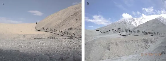
图4 a 木吉断裂照片,b慕士塔格断裂照片Fig.4 Photos showing faults in the Muji-Kashikurgan Valley

图5 阿克陶县布伦口活动断裂示意图Fig.5 Sketch map of active fault in Bulunkou in the County Aketao
苏巴什东侧的正断层出露特征与布伦口相近(图6)。断层东侧为隆起的高大山脉,断层错断了至少中更新世以来的地层(断层向下错断的地层没有出露)。正断层同时具有右行走滑的运动性质。
通过资料厘定与野外调查,1895年的新疆塔什库尔干大地震震中位于谷地南侧的塔合曼乡,地震使得慕士塔格和塔合曼正断裂发生破裂,形成27 km走向NNE的地表破裂带。根据地表破裂带宽度、单条陡坎垂直位移等信息估算的地质矩阵级也可达到7级以上(李文巧等,2011)。此次地震后的余震也曾达到6级以上。
这些正断层的活动对谷地的形成至关重要,是青藏高原西构造结东侧应力持续作用与岩石特性共同作用的结果。尽管慕士塔格断裂下盘变质岩中锆石年龄及岩体锆石低温热年代学揭示的快速隆升可能在晚中新世就已经存在(Robinson et al,2012;Thiede et al,2013),根据正断裂错断的地层分析,正断层至少在早-中更新世已经非常活跃。磷灰石裂变径迹年代学及锆石低温年代学同时发现公格尔山和慕士塔格在早更新世也发生了非常显著的隆起(Arnaud et al,1993;Robinson et al,2012)。木吉-塔什库尔干谷地可能就是其东侧山脉早更新世以来快速隆起造成重力失稳而形成正断裂开始发育,之后在右行走滑断裂共同作用下形成了现在的地貌特征。

图6 阿克陶县苏巴什一带正断裂示意图Fig.6 Sketch map of active fault in Subash in the County of Aketao
3 晚新生代以来帕米尔生长过程及其与塔里木盆地干旱化加剧的关系
塔里木盆地钻探岩芯研究显示,晚中新世到早上新世盆地干旱化明显加剧,这一气候变化过程可能与Messinian Salinity Crisis有联系(Sun et al,2008;Chang et al,2012),盆地周边山体隆起可能对这一变化同样具有重要的意义(Chang et al,2013;Liu et al,2014)。因为:(1)根据现在GPS速度场数据显示的帕米尔高原最北部逆冲断裂吸收的缩短量为10 — 15 mm · a-1(Mohadjer et al,2010;Ischuk et al,2013),那么在6 Ma以来沿断裂可能缩短了60 — 90 km的距离。以平均缩短量75 km、现在帕米尔高原南北300 km计算,当时的高原南北大约375 km,根据物质量的计算,晚中新世之前有部分高原及阿莱谷地的高度可能在3000 m之下。这种高度还不足以影响西风气流的通过。之后可能由于高原继续向北逆冲造成地壳增厚与地表隆起,使得高原的高度超过了3000 m甚至达到更高的高度,造成到达高原的西风气流明显分为南北两个分支,将其携带的水汽带到了高原南部和东部,而塔里木盆地干旱化就会明显加剧(Liu and Yin,2001;Wu et al,2007)。(2)根据磷灰石裂变径迹及锆石(U-Th)/He年代学分析获得帕米尔高原东部的公格尔山和慕士塔格峰在最近5 Ma以来的垂向生长速率为(0.4 — 0.5)± 0.1 mm · a-1(Robinson et al,2012),以现在高原的高度为4000 — 7000 m计算,5 Ma以来它们应该生长了2000 — 2500 m,如果整个帕米尔高原在印度板块与欧亚板块碰撞过程中处于同一应力场作用下,那么帕米尔高原的垂向生长速率应该接近,考虑到现在高原的高度,在晚中新世之前高原大部分区域的高度应该小于3000 m,对西风气流直接进入塔里木盆地不造成明显的影响。随着高原高度的进一步增长,其对塔里木盆地气候变化的影响和强迫更加明显,最终在晚中新世-早上新世造成西风气流不能直接进入盆地,西风气流通过天山中的较低位置进入塔里木盆地,这会使得盆地干旱化的趋势明显加强。在全球新生代以来变冷趋势过程中,北半球冰量增加强迫西风环流南移(Jansen and Sjøholm,1991;Wolf and Thiede,1991;Thiede et al,1998; Luo et al,2009;Chang et al, 2012)及副特提斯海西退(Popov et al,2004;Sun et al,2013)造成到达这一位置的西风携带的水汽减少,可能对塔里木盆地干旱化加剧也有一定的影响。
木吉-塔什库尔干谷地正断裂揭示的下盘公格尔山和慕士塔格在早-中更新世快速的隆起与低温热年代学指示这些区域在2 — 1 Ma以来的快速冷却(Arnaud et al,1993;Robinson et al,2012)相一致。昆仑山黄土在0.88 Ma大范围出现,揭示了帕米尔高原和南部天山可能发生了又一次隆升(Fang et al,2002)。柴达木盆地古生物地层学揭示,青藏高原周边山地持续隆升造成整个高原在中更新世出现了冰川(Sun et al,1999),冰缘作用提供的风尘物质明显增多也支持大量的黄土堆积在昆仑山前出现。塔里木盆地中更新世气候变化研究结果的矛盾,可能与塔里木盆地周边山地有冰川活动相关。尽管孢粉组合揭示降水量可能高于实际情况,但是其反映的降水量在中更新世的减小可能是一种实际存在的事实(Hao et al,2012)。这一气候事件可能是由于全球冰量增加和帕米尔高原生长共同作用的结果。由于塔里木盆地周边特别是昆仑山和帕米尔高原的冰川活动,使得盆地周边存在季节性或者是永久性河流。这些河流滋润了盆地中零星分布的湖泊,造成了介形虫在这些湖泊中的再次出现与繁盛。而周边山地冰川的出现和全球冰量增加的共同作用也会使得盆地的温度降低,这会造成蒸发量的显著减少,这一过程会提高土壤水分。土壤水分的提高是造成其中磁化率升高的关键因素(Hu et al,2015)。但反映大范围内气候特征的孢粉组合显示,盆地在这一时期降水明显减少(Hao et al, 2012)。综上所述,帕米尔高原在早-中更新世的隆升促使塔里木盆地周边山体出现冰川活动,认识这一地貌变化过程能够对塔里木盆地不同气候代用指标指示的气候意义给与合理的解释。
4 结论
通过帕米尔高原GPS速度场、低温热年代学资料分析及木吉-塔什库尔干谷地正断层活动特征研究,获得了以下认识:
(1)帕米尔高原渐新世-中新世以来就开始了明显的生长,高原内部及周边的多列构造带活动明显。中新世晚期的强烈隆升是塔里木盆地在这一时期干旱化加剧的原因之一。
(2)木吉-塔什库尔干谷地东部一系列正断层可能是帕米尔高原东北部进一步隆升的表现,特别是公格尔山和慕士塔格的快速生长造成的重力失稳形成正断裂,谷地于早-中更新世开始形成。这期构造运动使得帕米尔高原接近现今的地貌特征。
(3)帕米尔高原在中-晚更新世早期的高度已经可能形成山岳冰川,这些冰川融水造成了塔里木盆地一些湖泊的出现与扩大,使得总体干旱背景下湖泊中介形虫的出现与不同种属的繁盛。
常秋芳, 常 宏. 2013. 罗布泊Ls2孔近7.1 Ma以来沉积物的环境磁学研究[J]. 第四纪研究, 33(5): 876 - 888. [Chang Q F, Chang H. 2013. The environmental magnetism study of core Ls2 in Lop Nor, Tarim since 7.1 Ma [J]. Quaternary Sciences, 33(5): 876 - 888.]
郝诒纯,关绍曾,叶留生,等. 2002. 塔里木盆地西部地区新近纪地层及古地理特征[J]. 地质学报, 76(3): 289 - 298. [Hao Y C, Guan S Z, Ye L S, et al. 2002. Neogene stratigraphy and palaeogeography in the western Tarim Basin [J]. Acta Geologica Sinica, 76(3): 289 - 298.]
李海兵, Vali F, 刘敦一, 等. 2007. 喀喇昆仑断裂的形成时代:锆石SHRIMP U-Pb年龄的制约[J]. 科学通报, 52(4): 438 - 447. [Li H B, Valli F, Liu D Y, et al. 2007. Forming age of the Karakorum fault: Constraints from Zircon SHIRIMP U-Pb chronology [J]. Chinese Science Bulletin, 52(4): 438 - 447.]
李文巧, 陈 杰, 袁兆德, 等. 2011. 帕米尔高原1895年塔什库尔干地震地表多段同震破裂与发震构造[J]. 地震地质, 33(2): 260 - 276. [Li W Q, Chen J, Yuan Z D. 2011. Coseismic surface ruptures of multi segments and seismogenic fault of the Tashkorgan Earthquake in Pamirs, 1895 [J]. Seismology and Geology, 33(2): 260 - 276.]
李文巧. 2014. 帕米尔高原东北部塔什库尔干谷地活动构造与强震[J]. 国际地震动态, (8): 35 - 41. [Li W Q. 2014. Active tectonic and strong earthquake in Kashkorgan valley in the Pamir Plateau [J]. Recent Developments in World Seismology, (8): 35 - 41.]
李羿芃, 丁 林, 刘德亮, 等. 2013. 帕米尔高原沙克达拉穹窿变质作用及新生代下地壳演化[J]. 地质科学, 48(2): 468 - 483. [Li Y F, Ding L, Liu D L, et al. 2013. The Cenozoic metamorphism and tectonic evolution of the lower crust of Shakhdara dome, Tarim Mountains [J]. Chinese Journal of Geology, 48(2): 468 - 483.]
刘栋梁, 李海兵, 潘家伟. 等. 2011. 帕米尔高原东北缘-西昆仑的构造地貌及其构造意义[J]. 岩石学报, 27(11): 3499 - 3512. [Liu D L, Li H B, Pan J W, et al. 2011. Morphotectonic study from the northeastern margin of the Pamir to West Kunlun range and its tectonic implications [J]. Acta Patrologica Sinica, 27(11): 3499 - 3512.]
潘家伟, 李海兵, Van der Woerd J, 等. 2009. 青藏高原西北部帕米尔东北缘构造地貌与活动构造研究[J]. 第四纪研究, 29(3): 586 - 598. [Pan J W, Li H B, Van der Woerd J, et al. 2009. Tectonic geomorphology and active tectonics in northeastern Pamir, northwestern Margin of the Qinghai-Tibetan Plateau [J]. Quaternary Sciences, 29(3): 586 - 598.]
孙东怀, 王 鑫, 李宝峰, 等. 2013. 新生代特提斯海演化过程及其内陆干旱化效应研究进展[J]. 海洋地质与第四纪地质, 33(4): 135 - 151. [Sun D H, Wang X, Li B F, et al. 2013. Evolution of Cenozoic Tethys and environmental effects on inland drought [J]. Marine Geology & Quaternary Geology, 33(4): 135 - 151.]
孙知明, 李海兵, 裴军令, 等. 2013. 帕米尔-西昆仑地区新生代古地磁结果及其构造意义[J]. 岩石学报, 29(9): 3183 - 3191. [Sun Z M, Li H B, Pei J L, et al. 2013. Paleomagnetic study of Cenozoic sediments from western Kunlun-Pamir and its tectonic implications [J]. Acta Petrologica Sinica, 29(9): 3183 - 3191.]
张培震, 邓起东, 杨小平, 等. 1996. 天山的晚新生代构造变形及其地球动力学问题[J].中国地震, 12(2): 127 - 140. [Zhang P Z, Deng Q D, Yang X P, et al. 1996. Late Cenozoic tectonic deformation and mechanism along the Tianshan Mountain, northwestern China [J]. Earthquake Research in China, 12(2): 127 - 140.]
An Z S, Sun Y B, Chang H, et al. 2014. Late Cenozoic climate change in Monsoon Arid Asia and global changes [M]// An Z S. Late Cenozoic climate change in Asia. Heidelberg: Springer: 491 - 581.
Arnaud N O, Brunel M, Cantagrel J M, et al. 1993. High cooling and denudation rates at Kongur Shan, eastern Pamir (Xinjiang, China) revealed by40Ar/39Ar alkali feldspar thermochronology [J]. Tectonic, 12(6): 1335 - 1346.
Bazhenov M L, Perroud H, Chauvin A, et al. 1994. Paleomagnetism of Cretaceous red beds from Tadjikistan and Cenozoic deformations related to the India-Eurasia collision [J]. Earth and Planetary Science Letters, 124: 1 - 18.
Bershaw J, Garzione C N, Schoenbohm L, et al. 2012. Cenozoic evolution of the Pamir Plateau based on stratigraphy, zircon peovence, and stable isotopes of foreland basin sediments at Oytag (Wuyitake) in the Tarim Basin (west China) [J]. Journal of Asian Earth Science, 44: 136 - 148.
Bosboom R E, Dupont-Nivet M, Houben A J P, et al. 2011. Late Eocene sea retreat from the Tarim Basin (west China) and concomitant Asian paleoenvironmental change [J]. Paleogeography, Palaeoclimatology, Palaeoecology, 299: 385 - 398.
Burtman V S, Molnar P. 1993. Geological and geophysical evidence for deep subduction of continental crustal beneath the Pamir [J]. Geological Society of America Special Papers, 281: 1 - 76.
Burtman V S. 2000. Cenozoic crustal shortening between the Pamir and Tien Shan and a reconstruction of the Pamir-Tien Shan transition zone for the Cretaceous and Palaeogene [J]. Tectonophysics, 319: 69 - 92.
Chang H, An Z S, Liu W G, et al. 2012. Magnetostratigraphic and paleoenvironmental records for a Late Cenozoic sedimentary sequence drilled from Lop Nor in the eastern Tarim Basin [J]. Global and Planetary Science, 80 / 81: 113 - 122.
Chang H, An Z S, Wu F, et al. 2013. A Rb/Sr record of the weathering response to environmental changes in westerly winds across the Tarim Basin in the late Miocene to the early Pleistocene [J]. Paleogeography, Palaeoclimatology, Palaeoecology, 386: 364 - 373.
Coutand I, Strecker M R, Arrowsmith J R, et al. 2002. Late Cenozoic tectonic development of the intramontane Alai Valley, (Pamir-Tien Shan region, central Asia): An example of intracontinental deformation due to the Indo-Eurasia collision [J]. Tectonics, 21(6), 1053, doi: 10.1029/2002TC001358.
Cowgill E. 2010. Cenozoic right-slip faulting along the eastern margin of the Pamir salient northwestern China [J]. Geological Society of America Bulletin, 122(1/2): 145 - 161.
Fan G W, Ni J F, Wallace T C. 1994. Active tectonics of the Pamirs and Karakorum [J]. Journal of Geophysical Research, 99(B4): 7131 - 7160.
Fang X M, Lü L Q, Yang S L, et al. 2002. Loess in Kunlun Mountains and its implications on desert development and Tibetan Plateau uplift in west China [J]. Science China (D), 45(2): 289 - 299.
Gradstein F, Ogg J, Schmitz M, et al. 2012. The geological time scale 2012 [M]. Amsterdam: Elsevier: 923 - 978.
Hao H, Ferguson D K, Chang H, et al. 2012. Vegetation and climate of the Lop Nur area, China, during the past 7 million years [J]. Climatic Change, 113: 323 - 338.
Hu P X, Liu Q S, Heslop D, et al. 2015. Soil moisture balance and magnetic enhancement in loess-paleosol sequences from the Tibetan Plateau and Chinese Loess Plateau [J]. Earth and Planetary Science Letters, 409: 120 - 132.
Ischuk A, Bendick R, Rybin A, et al. 2013. Kinematics of the Pamir and Hindu Kush region [J]. Journal of Geophysical Research: Solid Earth, 118: 2408 - 2416.
Jansen E, Sjøholm J. 1991. Reconstruction of glaciation over the past 6 Myr from ice-bone deposits in the Norwegian Sea [J]. Nature, 349: 600 - 603.
Liu W G, Liu Z H, An Z S, et al. 2014. Late Miocene episodic lakes in the arid Tarim Basin, western China [J]. Proceeding of the National Academy Sciences of the United States ofAmerica, 111: 16292 - 16296.
Liu X D, Sun H, Miao Y F, et al. 2015. Impacts of uplift of northern Tibetan Plateau and formation of Asian inland deserts on regional climate and environment [J]. Quaternary Science Reviews, 116: 1 - 14.
Liu X D, Yin Z Y. 2001. Spatial and temporal variation of summer precipitation over the Eastern Tibetan Plateau and North Atlantic Oscillation [J]. Journal of Climate, 14: 2896 - 2909.
Luo C, Peng Z C, Yang D, et al. 2009. A lacustrine record from Lop Nur, Xinjiang, China: Implications for paleoclimate change during Late Pleistocene [J]. Journal of Asian Earth Sciences, 34: 38 - 45.
Mohadjer S, Bendick R, Ischuk A, et al. 2010. Partitioning of India-Eurasia convergence in the Pamir-Hindu Kush from GPS measurements [J]. Geophysical Research Letters, 37, L04305, doi: 10.1029/2009GL041737.
Molnar P, England P, Martinod J. 1993. Mantle dynamics, uplift of the Tibetan Plateau, and the Indian Monsoon [J]. Reviews of Geophysics, 31(4): 357 - 396.
Molnar P, Stock J M. 2009. Slowing of India’s convergence with Eurasia since 20 Ma and its implications for Tibetan mantls dynamics [J]. Tectonics, 28, TC3001, doi:10.1029/2008TC002271.
NegredoA M, Replumaz A, Villasenor A, et al. 2007. Modeling the evolution of continental subduction processes in the Pamir-Hindu Kush region [J]. Earth and Planetary Science Letters, 259: 212 - 225.
Pavlis T, Hamburger M W, Pavlis G L. 1997. Erosional processes as a control on the structural evolution of an actively deforming fold and thrust belt: An example from the Pamir-Tien Shan region, central Asia [J]. Tectonics, 16(5): 810 - 822.
Popov S V, Rögl F, Rozanov A Y, et al. 2004. Lithological-Paleogeographic maps of Paratethys: 10 maps late Eocene to Pliocene [M]. Courier Forschungsinastitut Senckenberg, 250: 1 - 46.
Ritts B, Yue Y J, Greham S A, et al. 2008. From sealevel to high elevation in 15 Million years: Uplift history of the northern Tibetan Plateau margin in the Altun Shan [J]. Americal Journal of Science, 308: 657 - 678.
Robinson A C, Ducea M, Lapen T J. 2012. Detrial zircon and isotopic constraints on the crustal architecture and tectonic evolution of the northeastern Pamir [J]. Tectonics, 31, TC2016, doi: 10. 1029/2011TC003013.
Savostin L A, Sibuet J C, Zonenshain L P, et al. 1986. Kinematic evolution of the belt from the Atlantic Ocean to the Pamirs since the Triassic [J]. Tectonophysics, 123: 1 - 35.
Schmidt J, Hacker B R, Ratschbacher L, et al. 2011. Cenozoic deep crust in the Pamir [J]. Earth and Planetary Science Letters, 312: 411 - 421.
Sobel E R, Dumitru T A. 1997. Thrusting and exhumation around the margin of the western Tarim Basin during the India-Asia collision [J]. Journal of Geophysical Research, 102: 5043 - 5063.
Sun J M, Jiang M S. 2013. Wocene seawater retreat from the southwest Tarim Basin and implications for early Cenozoic tectonic evolution in the Pamir Plateau [J]. Tectonopgysics, 588: 27 - 38.
Sun J M, Zhang L Y, Deng C L, et al. 2008. Evidence for enhanced aridity in the Tarim Basin of China since 5.3 Ma [J]. Quaternary Science Reviews, 27: 1012 - 1023.
Sun Z C, Feng X J, Li D M, et al. 1999. Cenozoic Ostracoda and palaeoenvironments of the northeastern Tarim Basin, western China [J]. Paleogeography, Palaeoclimatology, Palaeoecology, 148: 37 - 50.
Tang Z H, Dong X X, Wang X, et al. 2015. Oligocene-Miocene magnetostratigraphy and magnetic anisotropy of the Baxbulak section from the Pamir-Tian Shan convergence zone [J]. Geochemistry, Geophysics, Geosystems, 16: 3675 - 3592.
Thiede J, Winkler A, Wolf-Welling T, et al. 1998. Late Cenozoic history of the polar north Atlantic: results from ocean drilling [J]. Quaternary Science Reviews, 17: 185 - 208.
Thiede R C, Sobel E R, Chen J, et al. 2013. Late Cenozoic extension and crustal doming in the India-Eurasia collision zone: New thermohcronologic constraints from the NE Chinese Pamir [J]. Tectonics, 32: 763 - 779.
Wolf T C W, Thiede J. 1991. History of terrigenous sedimentation during the past 10 m.y. in the North Atlantic (ODP Legs 104 and 105 and DSDP Leg 81) [J]. Marine Geology, 101: 83 - 102.
Wu G X, Liu Y M, Wang T M, et al. 2007. The influence of mechanical and thermal forcing by the Tibetan Plateau on Asian climate [J]. Journal of Hydrameteology — Special Section, 8: 770 - 789.
Yin A, Rumelhart P E, Butler R, et al. 2002. Tectonic history of the Altyn Tagh fault system in northern Tibet inferred from Cenozoic sedimentation [J]. Geological Society of America Bulletin, 114(10): 1257 - 1295.
Link between development of the northeast Pamir Plateau and climate changes in the Tarim Basin
ZHANG Biao1, LI Leyi2,3, LIU Xiangdong1, HE Ningqiang1, DU Biao1, SONG Yuanli1, CHANG Hong2
(1. Shaanxi Central of Geological Survey, Xi’an 710068, China; 2. State Key Laboratory of Loess and Quaternary Geology, Institute of Earth Environment, Chinese Academy of Sciences, Xi’an 710061, China; 3. University of Chinese Academy of Sciences, Beijing 100049, China)
Background, aim, and scope The Pamir Plateau, the west syntaxis of the Tibetan Plateau, is located in the west to the Tarim Basin where climate is extremely arid. So, its evolution plays an important role to the growth of the Tibetan Plateau and aridification process in the Tarim Basin. Based on the studies of spatial distributions, activity and age of the normal fault in the northeastern Pamir, and observations on tectonics in the past several years, it is deduced that westerly wind was obstructed when flowing through directly since the Late Miocene when the Tibetan Plateau had been uplifted to a certain elevation. Tectonic events in the Pamir Plateau have been researched onvolcanism, sedimentology, metamorphism, deformations of the geological materials, low temperature chronology, and Global Positioning System (GPS). Evolution of climatic changes also has been carried out because the high-resolution drilling cores obtained from the eastern Tarim Basin. Comparison possible elevations of the Pamir Plateau and the significant climatic changes in the Tarim Basin in special time windows since Late Miocene can shed light on their correlation. Materials and methods In this study, we calculate probable elevation in different geologic times according to GPS data and low temperature measurements published in recent decades. Field works in the Muji-Tashkorgan valley in northeastern Pamir show that normal faults have initiated at least since Late Pleistocene. This suggests that obviously uplift occurred in this region since that time. The elevations of the Pamir Plateau were estimated when the signifi cant climate change occurred in Late Miocene. Results The results of the GPS and low temperature thermochronologies showed that even if the east-west extensive stress occurred in the Pamir since late Middle Miocene, uplift occurred in the northeastern Pamir Plateau. Paleoelevation of the Pamir Plateau was lower than 3000 m on the base of the data from these observations since transition of the Late Miocene and Early Pliocene, calculated from shortening amount of the crust stemmed from recent GPS data (10 — 12 mm · a-1). The similar result is obtained on the base of the uplift rate came from the low temperature thermometers (0.5 —0.4 mm · a-1). The oldest sediment observed in hanging wall of the normal faults in Muji-Tashkorgan valley is composed of the Early-Middle Pleistocene. So, Muji-Tashkorgan valley developed at least since the Early-Middle Pleistocene on the setting of pressure stress state in the north of the Pamir Plateau. Discussion If these are the cases, the west wind could reach the Tarim Basin directly before Late Miocene. Because the elevation of the Pamir Plateau uplifted in Late Miocene, the west wind weakened and part of it cannot reach the Tarim Basin directly. This process can decrease the moisture and enhance the aridifi cation in the basin. Elevation increased attributed to the progressively tectonic uplift since Late Pleistocene triggered development of the mountain glacial, and most of the amount of the water reached the basin would block in the high mountains, rivers and lakes in the basin. The variation made amount of the water volume increase in lakes on the background of enhanced aridifi cation in whole basin. It makes climate proxies of index complicated, which came from different sedimentary documents, especially the eolian deposits. These tectonic and climatic events shaped the geomorphology of the Pamir Plateau since Late Miocene which is located between the Himalaya and South Tianshan. And since Late Miocene, climate feature of the Tarim Basin was mostly influenced by the decrease of moisture because of the uplift of the Pamir Plateau and the migration southward of the west wind drove by increasing ice volume in the north hemisphere, even through retreat of the Paratethys Sea play minor role. We argue in this study that evolution of the tectonic geomorphology of the Pamir Plateau caused the enhancement of aridification and complicated interpretation to climatic proxies in the Tarim Basin since Late Miocene. Conclusions Growth of the Pamir Plateau has started since Oligocene-Miocene, and activities were observed along several fault belts inner and around the plateau. The normal faults along the eastern Muji-Kashkorgan valley suggested that east part of the plateau has still uplifted since early-middle Pleistocene. Height of the plateau can influence climate changes in the Tarim Basin because it may be obstruct the westerly circulation. Recommendations and perspectives The results about the evolution of the Pamir remained controversial, for an example, the development age from Eocene to Pleistocene. Detail process (including elevations and rates in different geologic times) of its uplift should be study on the top plateau and in the surrounding basins.
Pamir Plateau; valley; normal fault; slip fault; tectonic uplift; aridifi cation
CHANG Hong, E-mail: changh@loess.llqg.ac.cn
10.7515/JEE201604003
2015-12-02;录用日期:2016-05-12
Received Date:2015-12-02;Accepted Date:2016-05-12
国家自然科学基金项目(41420104008,41572166,41290252)
Foundation Item:National Natural Science Foundation of China (41420104008, 41572166, 41290252)
常 宏,E-mail: changh@loess.llqg.ac.cn
