兰州盆地第三纪沉积物常量元素变化及其古环境意义
2016-03-13刘星星李再军孙东怀孙有斌
王 扬,刘星星,李再军,孙东怀,孙有斌
(1.中国科学院地球环境研究所 黄土与第四纪地质国家重点实验室,西安710061;2.中国科学院大学,北京 100049;3. 兰州大学 西部环境教育部重点实验室,兰州 730000)
兰州盆地第三纪沉积物常量元素变化及其古环境意义
王 扬1,2,刘星星1,2,李再军3,孙东怀3,孙有斌1
(1.中国科学院地球环境研究所 黄土与第四纪地质国家重点实验室,西安710061;2.中国科学院大学,北京 100049;3. 兰州大学 西部环境教育部重点实验室,兰州 730000)
通过对兰州盆地凤凰山剖面沉积物(厚约2484 m)的常量元素(Si、Al、Ca、Fe、K、Mg、Na)和碳酸盐含量分析,发现元素含量变化特征可分为三类:(1)元素Al、Fe、K和Mg赋存于细颗粒矿物中,与粒度分选和风化强度关系密切;(2)元素Si主要赋存于石英中,能良好反映沉积相变化;(3)元素Ca、Na与化学沉积盐类的生成有关,元素比值(Na/Al和Ca/Al)能揭示沉积环境演变。元素比值变化表明兰州盆地第三纪古环境变化可划分为四个阶段:54 —43 Ma为三角洲河流相沉积,气候较温暖湿润;43—33 Ma Na/Al比值较高,钠盐大量生成,进入盐湖发育阶段,气候开始变干;33 — 23 Ma Ca/Al比大幅度波动,地层中含有大量石膏层,盆地经历了半干旱—半湿润的气候环境波动;23—9 Ma盆地从咸水-半咸水湖转变为风尘主导的干旱环境。综合凤凰山剖面的元素、磁化率、色度和粒度结果,认为第三纪以来兰州盆地古环境经历了三次阶段性变干的过程(~43 Ma,~33 Ma和~23 Ma);同全球气候和区域构造记录的对比表明,前两次变干可能同全球气候变冷关系密切,而早中新世的变干则可能是区域构造运动的结果。
兰州盆地;第三纪;常量元素;沉积相;古环境
兰州盆地是我国开展第三系研究较早的地区之一,包含了丰富的哺乳动物化石,经历了显著的沉积环境演化。上世纪开始,谢家荣(1921)、Young and Bien(1937)、胡敏(1946)、路兆洽(1948)、杨锺健(1948)等,先后多次对盆地的第三系地层和化石进行了全面的调查和对比研究。甘肃区调队建立的下第三系西柳沟组(古新统—始新统)、野狐城组(渐新统),上第三系咸水河组(中新统)、临夏组(上新统)是目前被广泛应用的地层单元(甘肃省地质局区域地质调查队,1984)。随后,邱占祥等(邱占祥和谷祖纲,1988;邱占祥等,1997,1998;邱占祥和谢骏义,1997;邱占祥和王伴月,1999)在兰州盆地发现了丰富的哺乳动物化石,命名了南坡坪动物群、狭沟动物群、张家坪动物群和对亭沟动物群。岳乐平等(2000,2003)对兰州盆地永登剖面第三系沉积物进行了磁性地层学和沉积学研究,建立了第三系地层古地磁年代序列。张炎等(2010)通过对皋兰山剖面沉积物的研究,表明兰州地区沉积地层在至少约7 Ma开始由河湖相向风尘沉积转变,气候开始干旱化;Zhang et al(2014)认为~26 Ma亚洲内陆大规模干旱化已经形成,兰州盆地风尘沉积显著增加。
沉积物中元素含量的变化对于指示气候冷暖干湿波动有重要意义。比如,钠是化学性质活泼的元素,在暖湿气候条件下易淋溶迁移,地层中钠含量的增加反映古气候向干冷趋势发展(舒强等,2001;靳鹤龄等,2003;赵锦慧等,2004);铁、铝较稳定而不易迁移,铝、全铁、钾、硅含量低时,反映了气候转干、降水减少、化学和生物作用减弱(张虎才等,1991)。另外,依据比值的变化可以表明元素的相对富集或分散,Na / K、Fe / Mg、Zr / Rb、K / Al、Ba / (Zr+Rb)、Ba / Al、Sr / (Zr + Rb)能很好地反映古气候、古环境意义(刘连文,2004)。鲁新川(2007)对临夏盆地14 — 4.4 Ma湖泊沉积物化学元素进行研究,表明CaO、Na2O和CaO / MgO比值与干旱气候成正比,并对其气候演化进行了阶段性划分(宋春晖等,2007)。前人对兰州盆地第三纪的研究多集中在动物群、古生物化石、岩石地层单元以及沉积相的研究,运用的指标多是粒度、磁化率、色度等,但关于兰州盆地第三系沉积物地球化学特征的研究基本没有涉及。本文通过对兰州凤凰山剖面9 — 54 Ma以来沉积物中常量元素的分析,结合地层特征以及沉积相变化,探讨第三系时期兰州盆地沉积物的元素地球化学特征及其古环境气候阶段和意义。
1 区域背景
兰州盆地位于青藏高原东北缘和黄土高原西缘(图1),是广义的第三纪陇中沉积盆地中次一级的中新生代盆地,海拔1500 m以上,位于黄河上游,处于东部季风湿润区、西北内陆干旱区和青藏高寒区三大自然区域的交汇地带,有我国“季风三角”的枢纽地区一说(李吉均等,2001)。兰州盆地特殊的地理位置,决定了该区对构造运动和环境变化的响应较其他地区更为敏感。兰州盆地是典型的温带半干旱大陆性季风气候,年平均气温9.3℃,年平均降水量360 mm,植被不甚发育,为草原植被至荒漠草原植被。研究区位于兰州盆地内,区内大部分地区为黄土所覆盖,比较完整地沉积了白垩纪晚期及第三纪以来不同时期的沉积物,盆地被自西向东再转向北东穿流而过的黄河横切,黄河南、北岸分布着不同时代的地层(图1)。
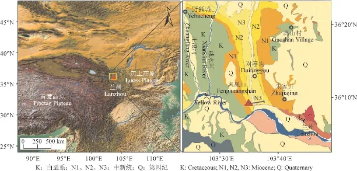
图1 兰州盆地凤凰山剖面位置图及区域内第三系地层分布Fig.1 Location of Fenghuangshan section in Lanzhou Basin and the Tertiary stratigraphic distribution in the area
兰州地区的典型剖面包括第四纪的九州台剖面(张虎才等,1991;张虎才,1993;刘现彬等,2012)、第三纪的南山剖面(胡文伟等,2011;Sun et al,2011)、永登剖面(岳乐平等,2000,2003;邓焰平等,2010)、皋兰山剖面(韩飞等,2010;张炎等,2010)、对亭沟剖面(Flynn et al,1999;Qiu et al,2013;张鹏等,2015)以及凤凰山剖面(张月宝等,2012;Zhang et al,2014)。第三纪地层在盆地不同位置厚度差异巨大,对亭沟厚约750 m(张鹏等,2015),永登剖面厚约1300 m(岳乐平等,2000),凤凰山剖面厚约2490 m(Zhang et al,2014),不同剖面沉积厚度的差异归因于其位于兰州沉积盆地的不同位置。其中,凤凰山剖面靠近盆地边缘,沉积地层连续稳定,地层时间跨度为9 — 54 Ma,剖面自下而上包含了三个组:西柳沟组、野狐城和咸水河组。岳乐平等(2000)认为西柳沟组古地磁年龄为58 — 51 Ma,野狐城组为51—31.5 Ma,咸水河组为31.5 — 15 Ma;Zhang et al(2014)认为西柳沟组为54 — 33 Ma,野狐城组为33 — 23.6 Ma,咸水河组为23.6 — 9 Ma。西柳沟组以河流沉积相为主,由一套红色块状砂岩和碎屑砂岩组成,具有交错层理;野狐城组是由含石膏夹层的紫红色泥岩和砖红色河流相砂岩组成,为河湖相沉积地层,基本上相当于西宁盆地西宁组的上部分(甘肃省地质局区域地质调查队,1984);咸水河组为河湖相沉积旋回夹风成粘土层(张月宝等,2012),下部主要是薄的泥岩夹有数层砂岩,上部多是粘土层,该组包含了5个地方哺乳动物群(邱占祥等,1997)。Zhang et al(2014)对该剖面进行了岩性、粒度、古地磁、色度、粉尘通量以及扫描电镜的研究,揭示了~26 Ma亚洲内陆大规模的干旱化已经开始出现,并在约22 Ma、14 Ma逐步加剧。
2 材料与方法
凤凰山剖面(36°09′10″N,103°36′15″E,图1)位于兰州市黄河以北的安宁区,厚约2484 m,包含有出露良好且沉积连续稳定的第三系地层。根据古地磁结果(Zhang et al,2014),对整个剖面进行不等间距(2—30 m)粉末样品挑选,其中咸水河组(厚约962 m)136个样品,野狐城组(厚约96 m)样品48个,西柳沟组(厚约1152 m)样品51个,共计235个样品,粉末样的年代依据古地磁结果线性内插获得。本研究所有样品由兰州大学孙东怀教授提供。所挑粉末样品称取10 g烘干,用Bartington MS2型双频(475 Hz和4750 Hz)磁化率仪测量,获得样品的磁化率值,用于同已发表数据的深度对比。
常量元素测量采用X射线荧光光谱分析法(XRF)。具体步骤如下:将样品放在38℃烘箱里充分烘干后,取10 g用研磨机研磨2分钟,颗粒大小为200目(75 μm)以下,称取试样6 g在30吨压力下制成32 mm直径的圆片,之后送入波长色散型X荧光光谱测试仪(WD-XRF)上进行常量元素(Si、Al、Ca、Fe、K、Mg、Na)组成分析。测试过程中利用12个水系沉积物标准物质(GSD-1 — 12)和16个国家土壤标准物质(GSS-1 — 16)建立元素分析的工作曲线,其中对GSS-8进行了多次平行测试,常量元素分析的不确定性在压片法中测量均小于1%。色度测量选取Konica Minolta公司生产的CM-700d分光测色计进行测试,扫描之前用于XRF测量的压片样,可获得L*、a*、b*以及400 —700 nm的反射光谱数据。碳酸盐的百分含量测试采用气量法,测定0.3 g样品与3 mL的10%的稀盐酸反应生成的CO2气体体积,利用公式:碳酸盐含量=气压×(测量值本底值)/(温度+273.15)/0.8309/样品质量,计算得到样品碳酸盐的百分含量。
3 结果
凤凰山剖面235个样品的元素分析结果和碳酸盐含量变化如表1所示。沉积物常量元素主要由Si、Al、Ca、Fe、K、Mg、Na组成,含量依次降低。Si含量高达39.48%,低至8.07%,平均值为26.5%;Al含量在1.45% — 9.65%变化,平均值为6.1%;Ca含量的变化范围为0.32% — 14.9%,均值为5.7%;Fe(0.49% — 5.2%)、K(0.26% — 3.52%)、Mg(0.16% — 3.15%)、Na(0.13% — 3.29%)元素含量变化范围略小,平均值分别为2.8%、2.0%、1.6%、1.3%。碳酸盐含量在3.0% — 28.99%变化,平均值为11.66%,变化幅度较大。

表1 碳酸盐校正前后常量元素含量对比Tab.1 Comparison of carbonate-free basis concentrations and bulk contents of major elements
由于测量的常量元素含量变化可能受到碳酸盐含量变化的影响,不能真实反映元素本身的含量变化(文启忠,1989)。为了获得元素含量真实变化,将剖面中常量元素含量进行碳酸盐百分含量校正以除去碳酸盐对元素的影响,公式为:校正值=测量值/(1- CaCO3含量),校正前后常量元素含量变化的相关性分析见表1。结果表明,Si、Al、Fe、K、Mg、Na含量校正前后相关性都很高,其中Si的r2> 0.91,其他元素r2> 0.99,说明常量元素含量受到碳酸盐含量的影响非常微弱,元素含量的变化基本可以代表其本身的变化规律。Ca元素通过公式:校正值=测量值- 0.4×CaCO3进行校正,校正前后的相关性很小(r2= 0.298),说明Ca主要赋存于碳酸盐矿物中。本文选取经碳酸盐含量校正后的元素含量值进行进一步分析与讨论。
为了进一步分析常量元素含量的变化特征,将校正后的常量元素分别和Al做相关性分析(图2)。结果显示Fe(r2= 0.9481)、K(r2= 0.7947)、Mg(r2= 0.8057)和Al呈较高的正相关,Na(r2= 0.1244)和Ca(r2= 0.1129)与Al相关性较差。Si与Al的关系表现地较复杂,可以将其分成三个阶段,在9 — 23 Ma和33—54 Ma Si和Al有一定的正相关(r2> 0.6),22—33 Ma阶段二者基本没有相关性(r2= 0.1718)。据此,将7种常量元素变化大至分为三类:(1)Al、Fe、K、Mg;(2)Si;(3)Ca、Na,进一步分析控制沉积物常量元素含量变化的因素。
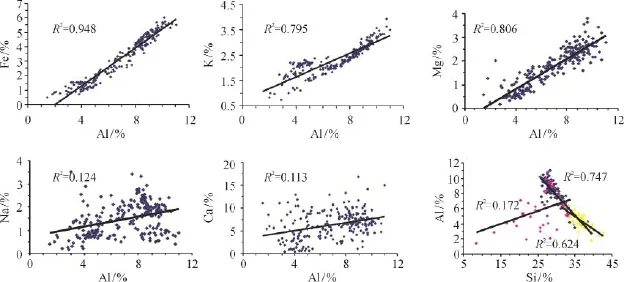
图2 常量元素与Al的相关性分析(Al和Si分成三组地层分别做相关性分析)Fig.2 Correlation analysis between major elements and Al (Al and Si were divided into three groups for the formation correlation analysis)
第一类元素Al、Fe、K、Mg之间具有很好的一致性,表现出明显的阶段性特征(图3)。4条元素含量变化曲线由老至新呈现出增加的趋势,大致可以划分为三段:西柳沟组(2012 —3158 m)各元素含量都较低且变化波动较小;野狐城组和咸水河组下部(1438 — 2012 m)元素含量都有所增加且有大幅度高低值频繁交替出现;咸水河组中上部(903 — 1438 m)Al、Fe、K、Mg的含量均值处于最高的一个区段,震荡幅度较之前略小。
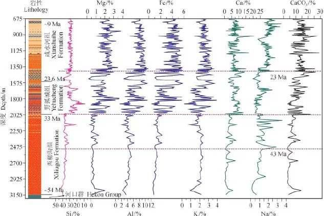
图3 凤凰山剖面岩性(Zhang et al,2014)和沉积物常量元素及碳酸盐含量变化Fig.3 Variations of lithology (Zhang et al, 2014), major element concentrations and carbonate content of Fenghuangshan section sediments
第二类元素Si除了在野狐城组和咸水河组下部的含量波动很大且频繁,其他阶段其含量没有大的波动(图3)。与地层岩性变化相对应,第三纪以来Si含量总体呈逐渐减小的趋势,西柳沟组以河流相块状砂岩为主,野狐城组和咸水河组下部为河湖相砂泥岩交互出现,咸水河组上部为厚的粘土层夹有数层砂岩。
第三类元素Ca和Na的含量变化趋势和变化幅度与其他元素并不一致。Ca含量在西柳沟组含量较低,自野孤城组(~2012 m)开始显著增加,咸水河组含量总体较高。Na含量在西柳沟组下部和野孤城组总体较低,而在西柳沟组上部和咸水河组总体较高。
4 讨论
4.1 常量元素变化对古环境的指示
沉积物元素含量变化控制因素较多,各地层单元中元素的迁移聚集受到气候、地形、源区物质化学成分的初始差异和化学元素自身特点的影响。兰州盆地第三纪以来复杂的沉积相变化使元素变化的解释更为复杂,单一的元素含量变化具有多解性,然而一定的元素组合却具有成因专属性,具有物源或者沉积环境的指示意义。从凤凰山剖面7种常量元素的分析结果可以看出,常量元素含量与沉积物类型和沉积相密切相关(图3)。
Al、Fe、K均为富集在偏细颗粒(粘土矿物、辉石、角闪石、铁氧化物、云母)中的稳定元素,Mg也易在细颗粒辉石、角闪石、黑云母等中富集。Al、Fe、K、Mg含量随沉积物粒度的减小逐步增大,并且Fe、K、Mg和Al有高的正相关关系,这些元素含量变化主要与粘土矿物密切相关,代表了细颗粒沉积物(粘土矿物)的影响,是元素含量变化的主要控制因素。元素含量变化既受搬运过程中动力分选作用的影响,较弱的搬运动力易携带较多的细颗粒矿物,又与物源区风化作用密切相关,通常干热气候条件下氧化作用强烈会导致硅酸盐矿物发生风化,形成更多的粘土矿物。在54 — 33 Ma,Al、Fe、K、Mg含量低且稳定,与粗颗粒的河流相砂岩有关,搬运动力较强,气候相对暖湿。在约33 Ma和23 Ma时段,4个元素的含量都有明显阶段性的增加,细颗粒物质输入增多。元素含量变化表明33 — 23 Ma气候波动较大,干湿交替出现,而22 Ma以来气候振荡幅度则大大减小。
Si主要存在于石英和各种硅酸盐矿物(辉石、角闪石、长石、云母)中,风化过程中辉石和角闪石被分解,长石、云母易转变为粘土矿物。因为石英较稳定,Si含量在剖面中的变化主要受到物质来源及风力分选作用的影响。一般而言,Si富集在偏粗颗粒,而Al富集在偏细颗粒中,二者呈反相关关系。然而,从Si与Al的相关性分析可以看出(图2),二者相关性受到沉积相变化控制。由于兰州盆地第三纪时期沉积环境波动频繁(岳乐平等,2003),砂岩中Si含量略高,而泥岩中Si含量降低,因此Si含量变化主要反映了沉积相的变化。54—33 Ma,高Si含量与河流相粗粒砂岩有关;33—22 Ma Si含量有所减小且波动频繁,反映当时河湖泊相(砂岩-泥岩)频繁的交互出现;22 Ma之后Si含量趋于稳定,地层以风尘沉积为主,偶夹河流相沉积。
Ca和Na在河流相、湖泊相、风尘沉积多变的环境下,除了存在于碎屑矿物方解石、云母、长石中,亦可赋存于湖泊自身的化学沉积过程形成的白云石CaMg(CO3)2、石膏(CaSO4水合物)和钠盐(NaCl等)中。Ca、Na和Al无明显的相关性,暗示了Ca、Na含量变化,更多反映了化学沉积生成盐类的情况。由于Ca和Na有多重来源,其环境意义存在多解性,相对的元素比值对沉积环境的演化更为敏感。Al元素在沉积物形成过程中相对稳定并且主要富集在粘土粒级中(余素华等,1994),故选择Al为稳定元素,计算元素的比值讨论元素的变化。下文将用Na /Al和Ca /Al比值来反映化学成因的盐类和石膏的生成情况,这些盐类的沉积受温度影响比较大,多见于干旱地区,可以反映湖泊咸淡变化和气候的干旱程度(孙小虹,2013;吕凤琳,2014;吕凤琳等,2015)。
4.2 区域环境变化过程及影响因素
Na /Al和Ca /Al比值变化表明兰州盆地沉积环境经历了显著变化(图4)。在43 — 33 Ma,Na /Al比值显著增高,说明这一时期钠盐大量生成,气候开始变干,盐湖开始发育。随后在33 —23 Ma,Ca/Al比值变化幅度显著增加,Na /Al比值较之前略有减小但仍比其他时段略高,表明~33 Ma开始石膏大量沉积并有一定的钠盐析出,与这个时间段沉积地层中有大量石膏层一致。石膏的形成需要一定的条件,除了要有一个集水成湖的盆地外,还需地面径流将周围土壤中的溶质带入湖中,并且蒸发量大于降水量,因此石膏形成的最佳环境为半干旱环境(王苏民,1993; Williams et al,1999)。自33 Ma开始,气候总体相对干旱,进入了咸水湖阶段,地层中数层呈条带状分布的石膏亦说明古气候明显的干湿波动。22 Ma以来,Na/Al和Ca/Al变小且趋于稳定,表明沉积环境变为淡水湖或者湖泊消亡。

图4 凤凰山剖面平均粒径、磁化率、红度(Zhang et al,2014)、同元素比值变化和深海氧同位素(Zachos et al,2001)对比Fig.4 Variations of mean size, magnetic susceptibility, redness (Zhang et al, 2014) and element ratios in Fenghuangshan section and their comparison with deep sea oxygen isotope records (Zachos et al, 2001)
结合前人的沉积相及相关代用指标变化研究结果(岳乐平等,2003;Zhang et al,2014),元素地球化学组成揭示出第三纪兰州盆地古环境的阶段性演化特征。在54 — 43 Ma为三角洲河流相沉积,地层中不含盐类夹层,主要由块状砂岩组成,颗粒较粗,显示盆地可能为开放的淡水湖盆;低磁化率值和高红度值,说明盆地环境较为温暖。43 — 33 Ma,以钠盐的大量生成为特征,此时进入了咸水湖发育阶段。此时段红度急剧减小,由于红度主要同赤铁矿含量相关,赤铁矿形成于相对炎热干燥的有氧环境中(Rossel et al,2006),它的含量变化主要与温度相关(Barron and Torrent,1986;Yang et al,2001;Yang and Ding,2003),说明此时段温度有所降低,因此,咸水湖的形成主要是降水减少而非蒸发增加所致,说明此时段气候经历了显著变干。在33 — 22 Ma为河流相和咸水湖相交替沉积,中等粒径的河湖相沉积物磁化率开始增加,地层中大量的石膏夹层及红度大幅度的变化,表明兰州盆地转为干冷和湿热的沉积环境频繁交替出现,出现了类似于现代的季风雏形。随后的22 — 9 Ma,表现为风尘沉积大量出现并夹有河湖相夹层,湖泊由咸水湖变为淡水湖,磁化率开始显著增加,同时红度逐渐变小,气候逐渐变冷,干旱化加剧。
基于深海氧同位素记录的全球气候变化自50 Ma开始表现为总体变冷(图4),在33 Ma有一次显著变冷,随后在26 Ma有所和缓,至15 Ma开始又显著变冷(Zachos et al,2001)。兰州盆地的西柳沟组和白垩纪河口群之间为角度不整合(~54 Ma)标志着新生代兰州盆地第一次重大构造事件,可能是由亚洲和印度的初始碰撞所致(Yin and Harrison,2000),这一事件使兰州盆地第三纪流域体系及沉积模式初步形成。从~ 43 Ma盆地内钠盐生成,到~33 Ma石膏大量析出,结合磁化率和红度变化,表明盆地气候逐渐变干和变冷的趋势。风尘组分含量分析表明,在33 — 22 Ma亚洲内陆干旱化已具有一定规模,26 Ma兰州盆地风成沉积已占显著优势(Zhang et al,2014)。晚渐新世至早中新世,秦安-天水盆地已有大量粉尘堆积出现(Guo et al,2002;Qiang et al,2011),同期我国西北地区发育石膏、盐岩沉积(刘东生,1997;刘东生等,1998)均显示了内陆干旱化的加剧。在渐新世/中新世界线,我国大陆环境的气候系统由行星风系为主导向季风风系转变(Sun and Wang,2005;Guo et al,2008),类似于现代的亚洲季风-干旱格局开始发育(施雅风等,1998;安芷生等,2006),可能和青藏高原北部在25 — 20 Ma的加速生长相关(Turner et al,1993;Xiao et al,2012;Sun et al,2015)。中新世开始,Na/Al和Ca /Al 比值变化总体稳定,对应了相对干旱的沉积环境,同风尘组分的显著增加标志的干旱化趋势一致。通过与全球气候变化趋势和区域构造证据初步对比,兰州盆地第三纪的三次阶段性变干的控制因素有所不同,前两次变化可能同全球气候变冷驱动的区域降水减少一致,类似的记录在西宁盆地也有显示(Zhang et al,2015),而23 Ma前后的变干可能是青藏高原北部的抬升,加剧了兰州盆地的干旱化(Zheng et al,2003)。
5 结论
通过对兰州凤凰山剖面沉积物的常量元素地球化学分析,认为不同元素组合可良好地揭示沉积古环境演化,尤其是化学沉积形成的盐类(Na)和石膏(Ca)相关元素含量,对盆地干旱气候的变化较为敏感。基于元素比值变化(Na/Al和Ca/Al),将兰州盆地第三纪沉积环境演变划分为四个阶段:54 — 43 Ma为三角洲河流相沉积,气候相对暖湿,盆地可能为开放的淡水湖盆;43 — 33 Ma钠盐生成,进入咸水湖发育阶段,气候变干变冷;33 — 23 Ma则是河流相和咸水近湖滨相沉积,地层中含有大量的石膏,盆地进入咸水湖阶段,兰州盆地转为半干旱-半湿润的气候且气候波动频繁;23 — 9 Ma为河流相和湖滨相沉积旋回并夹有风尘沉积,盆地经历了湖相逐渐变干的变化过程。自54 Ma以来,兰州盆地气候环境经历了阶段性的变干,分别出现在~43 Ma,~33 Ma和~22 Ma,与沉积相和多代用指标揭示的古气候变化历史是一致的。盆地古环境的变化可能受控于全球气候变化和青藏高原阶段式隆升两大因素,前者可能确定了长期的古环境演变趋势,而后者加速了亚洲干旱化的阶段性进程。
致谢:感谢中国科学院地球环境研究所吴枫副研究员在元素分析时提供的指导。
安芷生, 张培震, 王二七, 等. 2006. 中新世以来我国季风-干旱环境演化与青藏高原的生长[J]. 第四纪研究, 26(5): 678 – 693. [An Z S, Zhang P Z, Wang E Q, et al. 2006. Changes of the monsoon-arid environment in China and growth of the Tibetan Plateau science the Miocene [J]. Quaternary Sciences, 26(5): 678 – 693.]
邓焰平, 洪汉烈, 殷 科, 等. 2010. 兰州盆地永登剖面晚古新世—早渐新世沉积物中粘土矿物的特征及其古气候指示意义[J]. 现代地质, 24(4): 793 – 800. [Deng Y P, Hong H L, Yin K, et al. 2010. Clay mineralogy and its palaeoclimatic indicator of the late Paleocene to early Oligocene sediments in Yongdeng Lanzhou Basin [J]. Geoscience, 24(4): 794 – 800.]
甘肃省地质局区域地质调查队. 1984. 甘肃的第三系[J]. 甘肃地质, 2: 1 – 40. [Regional Geological Survey Team, Geological Bureau of Gansu Province. 1984. Tertiary system of Gansu [J]. Gansu Geology, 2: 1 – 40.]
韩 飞, 孙东怀, 张 焱, 等. 2010. 兰州地区晚第三纪磁性地层与古环境意义[J]. 地球物理学报, 53(5): 1179 – 1186. [Han F, Sun D H, Zhang Y, et al. 2010. Magnetostratigraphy and palaeoclimatic significance of Late Neogene aeolian sequence of Lanzhou area [J]. Chinese Journal of Geophysics, 53(5): 1179 – 1186.]
胡 敏. 1946. 关于甘肃第三纪几个问题之商榷[J]. 地质论评, (S2): 215 – 222. [Hu M. 1946. The discuss of several problems about Gansu Tertiary [J]. Geological Review, (S2): 215 – 222.]
胡文伟, 张月宝, 郭 峰, 等. 2011. 兰州地区晚新生代沉积的岩石磁学记录及其古环境意义[J].兰州大学学报(自然科学版), 47(5): 7 – 16. [Hu W W, Zhang Y B, Guo F, et al. 2011. Rock magnetic record for a late cenozoic sequence from Lanzhou area and its palaeoenvironmental implications [J]. Journal of Lanzhou University (Natural Sciences), 47(5): 7 – 16.]
靳鹤龄, 苏志珠, 孙 忠. 2003. 浑善达克沙地全新世中晚期地层化学元素特征及其气候变化[J]. 中国沙漠, 23(4):366 – 371. [Jin H L, Su Z Z, Sun Z. 2003. Characters of chemical elements in strata of middle and late Holocene in Hunshandake Desert and the indicating climatic changes [J]. Journal of Desert Research, 23(4): 366 – 371.]
李吉均, 方小敏, 潘保田,等. 2001. 新生代晚期青藏高原强烈隆起及其对周边环境的影响[J]. 第四纪研究, 21(5): 381 – 391. [Li J J, Fang X M, Pan B T, et al. 2001. Late Cenozoic intensive uplift of Qinghai-Xizang Plateau and its impacts on environments in surrounding area [J]. Quaternary Sciences, 21(5): 381 – 391.]
刘东生, 郑绵平, 郭正堂. 1998. 亚洲季风系统的起源和发展及其与两极冰盖和区域构造运动的时代耦合性[J].第四纪研究, 18(3): 194 – 204. [Liu T S, Zheng M P, Guo Z T. 1998. Initiation and evolution of the Asian monsoon system timely coupled with the icesheet growth and the tectonic movements in Asia [J]. Quaternary Sciences, 18(3): 194 – 204.]
刘东生. 1997. 中国第四纪环境概要[M]. 北京: 科学出版社: 189 – 239. [Liu T S. 1997. Summary on the Quaternary environments in China [M]. Beijing: Science Press: 189 – 239.]
刘连文. 2004. 元素地球化学在海陆沉积古环境研究中的应用[D]. 上海: 同济大学. [Liu L W. 2004. Application of element geochemistry in the study of sea and continental sedimentary paleoenvironment [D]. Shanghai: Tongji University.]
刘现彬, 夏敦胜, 贾 佳, 等. 2012. 兰州九州台黄土磁性特征及其古气候意义研究[J]. 第四纪研究, 32(4): 761 – 770. [Liu X B, Xia D S, Jia J, et al. 2012. Magnetic properties of Jiuzhoutai loess in Lanzhou and its signifi cance of palaeoclimate [J]. Quaternary Sciences, 32(4): 761 – 770.]
鲁新川. 2007. 临夏盆地14 — 4.4 Ma湖相沉积物元素地球化学特征与气候变化[D]. 兰州:兰州大学. [Lu X C. 2007. Elemental geochemical characters and palaeoclimatic changes of lacustrine sediments of 14 — 14.4 Ma in Linxia Basin [D]. Lanzhou: Lanzhou University.]
路兆洽. 1948. 关于甘肃及青海境内之第三纪红色地层[J].地质论评, (S2): 258 – 261. [Lu Z Q. 1948. The red strata of Tertiary in Gansu and Qinghai Province [J]. Geological Review, (S2): 258 – 261.]
吕凤琳, 刘成林, 焦鹏程, 等. 2015. 亚洲大陆内部盐湖沉积特征、阶段性演化及其控制因素探讨——基于罗布泊LDK01深孔岩心记录[J]. 岩石学报, 31(9): 2770 – 2782. [Lü F L, Liu C L, Jiao P C, et al. 2015. The discussion on sedimentary characteristics, phased evolution and controlling factors of saline lake in Asia interior: records from deep drill cores of LDK01 in Lop Nur, Xinjiang, northwestern China [J]. Acta Petrologica Sinica, 31(9): 2770 – 2782.]
吕凤琳. 2014. 罗布泊早更新世以来沉积环境演变及其地质意义[D]. 北京: 中国地质大学. [Lü F L. 2014. Evolution of depositional environment since early Pleistocene in Lop Nor, Xinjiang, China and its geological signifi cance [D]. Beijing: China University of Geosciences.]
邱占祥, 谷祖纲. 1988. 甘肃兰州——第三纪中期哺乳动物化石地点[J]. 古脊椎动物学报, 26(3): 198 – 223. [Qiu Z X, Gu Z G. 1988. A new locality yielding Mid-Tertiary mammals near Lanzhou, Gansu [J]. Vertebrata PalAsiatica, 26(3): 198 – 223.]
邱占祥, 王伴月, 邱铸鼎, 等. 1997. 甘肃兰州盆地咸水河组研究的新进展[M]. 北京: 海洋出版社: 177 – 192. [Qiu Z X, Wang B Y, Qiu Z D, et al. 1997. The new progress in the study of Xianshuihe group of Lanzhou Basin, Gansu [M]. Beijing: Ocean Press: 177 – 192.]
邱占祥, 王伴月, 谢骏义. 1998. 记兰州盆地第三纪中期的爪兽(奇蹄目)化石[J]. 古脊椎动物学报,36(4):297 – 318. [Qiu Z X, Wang B Y, Xie J Y. 1998. Mid-Tertiary Chalicothere (Perissodactyla) fossils from Lanzhou, Gansu, China [J]. Vertebrata PalAsiatica, 36(4): 297 – 318.]
邱占祥, 王伴月. 1999. Allacerops(奇蹄目、犀超科)化石在我国的发现及其分类地位的讨论[J]. 古脊椎动物学报, 37(1): 48 – 61. [Qiu Z X, Wang B Y. 1999. Allacerops (Rhinocerotoidea, Perissodactyla), its discovery in China and its systematic position [J]. Vertebrata PalAsiatica, 37(1): 48 – 61.]
邱占祥, 谢骏义. 1997. 记兰州盆地巨獠犀(奇蹄目,犀科)——新种[J]. 古脊椎动物学报, 35(4): 250 – 267. [Qiu Z X, Xie J Y. 1997. A new species of Aprotodon (Perissodactyla, Rhinocerotidae) from Lanzhou basin, Gansu, China [J]. Vertebrata PalAsiatica, 35(4): 250 – 267.]
施雅风, 汤懋苍, 马玉贞. 1998. 青藏高原二期隆升与亚洲季风孕育关系探讨[J]. 中国科学(D辑),28(3): 263 – 271. [Shi Y F, Tang M C, Ma Y Z. 1998. Link age between the second up lifting of the Qinghai-Xizang (Tibetan) Plateau and the initiation of the Asian monsoon system [J]. Science in China (Series D), 42(3): 303 – 312.]
舒 强, 钟 巍, 熊黑钢, 等. 2001. 南疆尼雅地区4000 a来的地化元素分布特征与古气候环境演化的初步研究[J].中国沙漠, 21(1): 12 – 18. [Shu Q, Zhong W, Xiong H G, et al. 2001. Study on the characters of the geochemical elements and changes of paleoclimate since about 4000 a B.P. in Niya Section [J]. Journal of Desert Research, 21(1): 12 – 18.]
宋春晖, 鲁新川, 邢 强, 等. 2007. 临夏盆地晚新生代沉积物元素特征与古气候变迁[J]. 沉积学报, 25(3): 409 – 416. [Sun C H, Lu X C, Xing Q, et al. 2007. Late Cenozoic element characters and palaeoclimatic change of the lacustrine sediments in Linxia Basin China [J]. Acta Sedimentologica Sinica, 25(3): 409 – 416.]
孙小虹. 2013. 罗布泊盐湖盐类矿物特征、成因与成钾作用[D]. 北京: 中国地质科学院. [Sun X H. 2013. Characteristics and genesis of salt minerals, and potash formation in the Lop Nur playa [D]. Beijing: Chinese Academy of Geological Science.]
王苏民. 1993. 世界咸水湖的物理与化学特性[J]. 湖泊科学, 5(3): 278 – 286. [Wang S M. 1993. Physics and chemistry of saline lakes [J]. Journal of Lake Science, 5(3): 278 – 286.]
文启忠. 1989. 中国黄土地球化学[M]. 北京: 科学出版社: 210 – 235. [Wen Q Z. 1989. Chinese loess geochemistry [M]. Beijing: Science Press: 210 – 235.]
Williams M A J, Dunkerley D L, Deckker P D, et al. 1999. 第四纪环境 [M]. 刘东生, 译. 北京: 科学出版社: 1 – 304. [Williams M A J, Dunkerley D L, Deckker P D, et al. 1999. Quaternary environment [M]. Liu T S, translated. Beijing: Science Press: 1 – 304. ]
谢家荣. 1921. 民国九年十二月甘肃地震报告[R]. [Xie J R. 1921. The earthquake report of nine years of the republic of China in Gansu [R].]
杨锺健. 1948. 甘肃享堂脊椎动物化石简报[J]. 地质论评, (S2): 199 – 202. [Young C C. 1948. The briefi ng of Gansu Xiangtang vertebrate fossils [J]. Geological Review, (S2): 199 – 202.]
余素华, 文启忠, 张士三, 等. 1994. 中国西北地区晚第四纪黄土中镁铝地球化学与古气候意义[J]. 沉积学报, 12(1): 112 – 116. [Yu S H, Wen Q Z, Zhang S S, et al. 1994. The Geochemistry and Paleoclimate Significance of Magnesium and Aluminium in Loess of Late Quaternary in Northwestern China [J]. Acta Sedimentologica Sinica, 12(1): 112 – 116.]
岳乐平, Heller F, 邱占祥, 等. 2000. 兰州盆地第三系磁性地层年代与古环境记录[J]. 科学通报, 45(18): 1998 – 2003. [Yue L P, Heller F, Qiu Z X, et al. 2000. Magnetuc stratigraphy and paleoenvironment records of Tertiary in Lanzhou Basin [J]. Chinese Science Bulletin, 45(18): 1998 – 2003.]
岳乐平, 邱占祥, 颉光普, 等. 2003. 兰州盆地永登剖面记录的第三纪沉积环境[J]. 沉积学报, 21(4): 683 – 694. [Yue L P, Qiu Z X, Xie G P, et al. Sedimentary environment of Tertiary recorded in the Yongdeng section of Lanzhou area [J]. Acta Sedimentologica Sinica, 21(4): 683 – 687.]
张 鹏, 敖 红, 安芷生, 等. 2015. 兰州盆地渐新世沉积物岩石磁学性质探究[J]. 地球物理学报, 58(7): 2445 – 2459. [Zhang P, Ao H, An Z S, et al. 2015. Rock magnetism properties of Oligocene sediments in the Lanzhou Basin [J]. Chinese Journal of Geophysics, 58(7): 2445 – 2459.]
张 炎, 孙东怀, 韩 飞, 等. 2010. 兰州地区新近纪地层的沉积相和古环境记录[J]. 沉积学报, 28(3): 612 – 619. [Zhang Y, Sun D H, Han F, et al. 2010. Depositional facies and paleoenvironmental record of the late Tertiary stratum of Lanzhou area [J]. Acta Sedimentologica Sinica, 28(3): 612—619.]
张虎才, 张林源, Mahaney W C. 1991. 兰州九州台黄土剖面元素地球化学研究[J]. 地球化学, (1): 79 – 86. [Zhang H C, Zhang L Y, Mahaney W C. 1991. Element geochemistry of the Jiuzhoutai loess section, Lanzhou [J]. Geochimica, (1): 79 – 86.]
张虎才. 1993. 九州台黄土剖面碳酸盐稳定同位素及其气候意义[J]. 兰州大学学报(自然科学版), 29(3): 232 – 240. [Zhang H C. 1993. The carbonate stable carbon and oxygen isotopes of the Jiuzhoutai loess profi le and their climatic significance [J]. Joutnal of Lanzhou University(Natural Sciences), 29(3): 232 – 240.]
张月宝, 孙东怀, 李再军, 等. 2012. 兰州地区新生代最老的风成沉积[J].地质学报, 86(3): 503 – 513. [Zhang Y B, Sun D H, Li Z J, et al. 2012. The oldest eolian deposit of Cenozoic in Lanzhou Area [J]. Acta Geologica Sinica, 86(3): 503 – 513.]
赵锦慧, 王 丹, 樊宝生, 等. 2004. 延安地区黄土堆积的地球化学特征与最近13万年东亚夏季风气候的波动[J].地球化学, 33(5): 495 – 500. [Zhao J H, Wang D, Pan B S, et al. Geochemical characteristics of the loess deposit at Yan’an and its implication to changes of East Asia summer monsoon during the past 130 ka [J]. Geochimical, 33(5): 495 – 500.]
Barron V, Torrent J. 1986. Use of the Kubelka-Munk theory to study the influence of iron oxides on soil colour [J].Journal of Soil Science, 37(4): 499 – 510.
Flynn L J, Downs W, Opdyke N, et al. 1999. Recent advances in the small mammal biostratigraphy and magnetostratigraphy of Lanzhou Basin [J]. Chinese Science Bulletin, 44(1): 105 – 118.
Guo Z T, Ruddiman W F, Hao Q Z, et al. 2002. On set of Asian desertification by 22 Myr ago inferred from loess deposition in China [J]. Nature, 416(6877): 159 – 163.
Guo Z T, Sun B, Zhang Z S, et al. 2008. A major reorganization of Asian climate regime by the early Miocene [J]. Climate of the Past Discussions, 4(3): 153 – 174.
Qiang X K, An Z S, Song Y G, et al. 2011. New eolian red clay sequence on the western Chinese Loess Plateau linked to onset of Asian desertifi cation about 25 Ma ago [J]. Science China Earth Science, 54(1): 136 – 144.
Qiu Z X, Qiu Z D, Deng T, et al. 2013. Neogene land mammal stages/ages of China—toward the goal to establish an Asian land mammal stage/age scheme [M]// Wang X, Flynn L J, Fortelius M. Fossil Mammals of Asia: Neogene Biostratigraphy and Chronology. New York: Columbia University Press: 29 – 90.
Rossel R A V, Minasny B, Roudier P, et al. 2006. Colour space models for soil science [J]. Geoderma, 133(3 / 4): 320 – 337.
Sun D H, Zhang Y B, Han F, et al. 2011. Magnetostratigraphy and palaeoenvironmental records for a Late Cenozoic sedimentary sequence from Lanzhou, Northeastern margin of the Tibetan Plateau [J]. Global and Planetary Change, 76(3/4): 106 – 116.
Sun X J, Wang P X. 2005. How old is the Asian monsoon system?—Palaeobotanical records from China [J]. Palaeogeography, Palaeoclimatology, Palaeoecology, 222(3 / 4): 181 – 222.
Sun Y B, Ma L, Bloemendal J, et al. 2015. Miocene climate change on the Chinese Loess Plateau: Possible links to the growth of the northern Tibetan Plateau and global cooling [J]. Geochemistry Geophysics Geosystems, 16(7): 2097 – 2108.
Turner S, Hawkesworth C, Liu J Q, et al. 1993. Tmiing of Tibetan uplift constrained by analysis of volcanic rocks [J]. Nature, 364(6432): 50 – 54.
Xiao G Q, Guo Z T, Dupont-Nivet G, et al. 2012. Evidence for northeastern Tibetan Plateau uplift between 25 and 20 Ma in the sedimentary archive of the Xining Basin, Northwestern China [J]. Earth and Planetary Science Letters, 317(2): 185–195.
Yang S L, Ding Z L. 2003. Color reflectance of Chinese loess and its implications for climate gradient changes during the last two glacial-interglacial cycles [J]. Geophysical Research Letters, 30(20), 2058, doi: 10.1029/2003GL018346.
Yang S L, Fang X M, Li J J, et al. 2001. Transformation functions of soil color and climate [J]. Science in China Series D, 44(1): 218 – 226.
Yin A, Harrison T M. 2000. Geologic evolution of the Himalayan-Tibetan orogen [J]. Annual Review of Earth & Planetary Sciences, 28(1): 211 – 280.
Young C C, Bien M N. 1937. Cenozoic geology of the Kaolan-Yungteng area of central Kansu [J]. Bulletin of the Geological Society of China, (S1): 221 – 245+247 – 260+505 – 514.
Zachos J, Pagani M, Sloan L, et al. 2001. Trends, rhythms, and aberrations in global climate 65 Ma to present [J]. Science, 292(5517): 686 – 693.
Zhang C X, Xiao G Q, Guo Z T, et al. 2015. Evidence of late early Miocene aridification intensification in the Xining Basin caused by the northeastern Tibetan Plateau uplift [J]. Global and Planetary Change, 128: 31 – 46.
Zhang Y B, Sun D H, Li Z J, et al. 2014. Cenozoic record of aeolian sediment accumulation and aridification from Lanzhou, China, driven by Tibatan Plateau uplift and global climate [J]. Global and Planetary Change, 120(3): 1 – 15.
Zheng D, Zhang P, Wan J, et al. 2003. Late Cenozoic deformation subsequence in northeastern margin of Tibet— detrital AFT records from Linxia basin [J]. Science in China Series D, 46(2): 266 – 275.
Major elemental compositions of Tertiary sediments in Lanzhou Basin and their paleoenvironment implication
WANG Yang1,2, LIU Xingxing1,2, LI Zaijun3, SUN Donghuai3, SUN Youbin1
(1. State Key Laboratory of Loess and Quaternary Geology, Institute of Earth Environment, Chinese Academy of Sciences, Xi’an 710061, China; 2. University of the Chinese Academy of Sciences, Beijing 100049, China; 3. MOE Key Laboratory of Western China’s Environmental Systems, Lanzhou University, Lanzhou 730000, China)
Background, aim, and scope The Lanzhou Basin is rich in Tertiary mammalian faunas and experienced signifi cant sedimentary environmental evolution, making it an ideal site for paleontological, sedimentological, magnetostratigraphical and paleoclimatic studies. Located in the northeastern margin of the Tibetan Plateau and the western margin of the Loess Plateau, the thick Cenozoic sedimentary sequence in Lanzhou provides critical evidence for the tectonic history of the northeastern part of the Tibetan Plateau and contains a large number of paleoenvironment information. The Fenghuangshan section is situated at the south edge of the Lanzhou Basin with continuous and stable strata ranging from9 Ma to 54 Ma. The Tertiary sedimentary systems of the basin are divided into three formations, i.e., the Xiliugou Formation, Yehucheng Formation and Xianshuihe Formation, in order of decreasing age. Previous work mostly concentrated in mammalian fossils, rock stratigraphic units and the sedimentary facies research by the use of indicators such as particle size, magnetic susceptibility, chroma in the Lanzhou Tertiary Basin. But the geochemical characteristics of Tertiary sediments in the Lanzhou Basin is hardly investigated. The variations of the elements content in the sediments can refl ect the fl uctuations of dry and wet climate. To explore the element geochemical characteristics and infer the stage and signifi cance of the Lanzhou Basin Tertiary sediments, we analyse the major elements of the sediments in the Fenghuangshan section at 9 — 54 Ma, combined with the strata features and the changes of sedimentary facies. Materials and methods We picked out 235 samples in the Fenghuangshan section, which has a total thickness of~2484 m. The sample age was obtained by linear interpolation of the paleomagnetic ages. Major elements were measured by X-ray fluorescence spectrometry (XRF). The CM-700d spectral color measurement meter produced by Konica Minolta Company was used to test the color of sediments. The percentage content of carbonate was measured by gas method, using the formula: carbonate content = pneumatic × background value(measured value)/(temperature+273.15)/0.8309/sample quality to calculate the percentage content of carbonate samples. Results The results show that the major elements of sediments consist mainly Si, Al, Ca, Fe, K, Mg, Na in descending order, and the element content are weakly affected by carbonate content. According to the results of the correlation of each element content and Al, the seven elements were divided into three categories: (1) Fe (r2= 0.9481), K (r2= 0.7947), Mg (r2= 0.8057) have a high positive correlation with Al. According to four element content curves, the results can be roughly divided into three parts with boundaries at 2012 m and 1438 m. (2) The relationship between Si and Al is more complex. There are little fl uctuations except that the elemental contents have large and frequent fl uctuation in the Yehucheng Formation and the lower part of the Xianhuihe Formation. (3) The correlation among Na (r2= 0.1244), Ca (r2= 0.1129) and Al are poor. The content of Ca was lower in the Xiliugou Formation, but increased signifi cantly from Yehucheng Formation (~2012 m) and was higher in the Xianshuihe Formation. The content of Na was quite low in the lower part of Xiliugou Formation and Yehucheng Formation, but generally high in the upper part of the Xiliugou Formation and the Xianshuihe Formation. Discussion The content of major element is closely related to sediment types and sedimentary facies, according to the results of the 7 major elements at the Fenghuangshan section. (1) Al, Fe, K, Mg that existed mainly in fi negrain minerals refl ect the effects of grain size sorting and/or weathering. In the period of 54 — 33 Ma, the contents of Al, Fe, K, Mg are low and stable, and associated with the coarse fl uvial facies sandstone, which has stronger transport power, related to warm and wet climate. The content of four elements have obvious periodic increase since 33 Ma, indicating the increasing of fi ne particle input. Changes of element content suggested that the climate had a great dry-wet oscillation in 33 — 23 Ma. (2) Si enriched in quartz is well related to the changing sedimentary facies. In stage of 54 — 33 Ma, the high content of Si is related to coarsegrained fluvial sandstone. However, during 33 — 22 Ma, the content reduced and fluctuated frequently, which refl ects the frequent interaction occurring of fl uvial-lacustrine facies (sandstone-mudstone). The Si content tends to be stable after 22 Ma, and the dust deposition dominated with the accidentally occurrence of fl uvial deposition. (3) Ca and Na may be associated with the formation of salts (i.e., salt and gypsum) during the chemical deposition, thus the Na/Al and Ca/Al ratios can be employed to infer the evolution of sedimentary environment. According to the element ratios and sedimentary facies research, the Tertiary paleoenvironmental evolution in the Lanzhou Basin can be divided into four stages: (1) fl uvial environment under a warm and humid climate at 54 — 43 Ma; (2) development of salt lake with high Na/Al ratios during 43 — 33 Ma; (3) fl uctuated salt lake from 33 Ma to 23 Ma with a signifi cant increase in Ca/Al ratioformed under semi-arid and semi-humid climate, and (4) shifts from salt-brackish lake to gradual aridifi cation environment lake after 23 Ma. Conclusions Combination of available proxy indicators including grain size, color, magnetic susceptibility and major elemental compositions suggests stepwise drying of the Lanzhou Basin occurred around 43 Ma, 33 Ma, and 23 Ma, respectively. Taking into account evidence of global cooling and regional tectonics, we tentatively attribute the fi rst two drying events to global cooling and the last drying in early Miocene to regional uplift of the northern Tibet Plateau. Recommendations and perspectives The results provide signifi cant stages of aridifi cation in the Lanzhou Basin. It is recommended that more work should be carried out to deepen the cognition of the Tertiary paleoenvironmental evolution in the Lanzhou Basin.
Lanzhou Basin; Tertiary; major elements; sedimentary facies; paleoenvironment
WANG Yang, E-mail: wangyang@ieecas.cn
10.7515/JEE201604007
2016-03-17;录用日期:2016-05-19
Received Date:2016-03-17;Accepted Date:2016-05-19
中国科学院战略性先导科技专项(XDB03020504)
Foundation Item:Strategic Priority Research Program of Chinese Academy of Sciences (XDB03020504)
王 扬,E-mail: wangyang@ieecas.cn