Characterization of Drought and Its Assessment over Sindh,Pakistan During 1951-2010
2015-11-21ShahzadaADNANKalimULLAHandGAOShouting高守亭
Shahzada ADNAN,Kalim ULLAH,and GAO Shouting(高守亭)
1 Department of Meteorology,COMSATS Institute of Information Technology(CIIT),Islamabad-44000,Pakistan
2 National Drought Monitoring Centre,Pakistan Meteorological Department,Islamabad-44000,Pakistan
3 Institute of Atmospheric Physics,Chinese Academy of Sciences,Beijing 100029,China
4 State Key Laboratory of Severe Weather,Chinese Academy of Meteorological Sciences,Beijing 100081,China
Characterization of Drought and Its Assessment over Sindh,Pakistan During 1951-2010
Shahzada ADNAN1,2∗,Kalim ULLAH1,and GAO Shouting3,4(高守亭)
1 Department of Meteorology,COMSATS Institute of Information Technology(CIIT),Islamabad-44000,Pakistan
2 National Drought Monitoring Centre,Pakistan Meteorological Department,Islamabad-44000,Pakistan
3 Institute of Atmospheric Physics,Chinese Academy of Sciences,Beijing 100029,China
4 State Key Laboratory of Severe Weather,Chinese Academy of Meteorological Sciences,Beijing 100081,China
Drought is one of the complex meteorological disasters affecting water resources,agriculture,livestock,and socioeconomic patterns of a region.Although drought prediction is difficult,it can be monitored based on climatological information.In this study,we provide high spatiotemporal resolution drought climatology,using observational,gridded precipitation data(0.5°×0.5°)from the Global Precipitation Climatological Center and soil moisture data from the Climate Prediction Center for the 60-yr period 1951-2010.The standardized precipitation index(SPI)based on a fitted Gamma distribution and Run method has been calculated from the regional drought identification model(ReDIM)for 3,6,9,12,and 24 months.The results show strong temporal correlations among anomalies of precipitation,soil moisture,and SPI.Analysis of long-term precipitation data reveals that the drought vulnerability concentrates on monsoon season(July-September),which contributes 72.4%and 82.1%of the annual precipitation in northern and southern Sindh,respectively.Annual and seasonal analyses show no significant changes in the observed precipitation.The category classification criteria are defined to monitor/forecast drought in the selected area.Further analysis identifies two longest episodes of drought,i.e.,1972-1974 and 2000-2002,while 1969,1974,1987,and 2002 are found to be the most severe historical drought years.A drought hazard map of Sindh was developed,in which 10 districts are recognized as highly vulnerable to drought.This study helps to explain the time,duration,intensity,and frequency of meteorological droughts over Sindh as well as its neighboring regions,and provides useful information to disaster management agencies and forecasters for assessing both the regional vulnerability of drought and its seasonal predictability in Pakistan.
climatology,drought,standardized precipitation index(SPI),regional drought identification model(ReDIM),Sindh
1.Introduction
Drought is caused naturally by the deficiency of rainfall over a prolonged period in an area,in which the lack of natural water availability leads to temporary deficiency(Vogt and Somma,2013).It is probably the worst natural disaster,which influences and causes the largest economic loss,affecting various aspects of life with great successive and potentially hazardous consequences(Zheng,2000;Zhang et al.,2011). Aridity is the climate characteristic used to describe a specific region(Wilhite,2012)where the available water resources are not sufficient to fulfill the long-term water demands of the region(Spinoni et al.,2014).In addition to the societal and environmental impacts of droughts,numerous droughts can lead to desertification and land degradation.This is the situation that arose between the 1960s and 1970s in the Sahel(Zeng,2003).
Drought is a creeping phenomenon.It developsgradually and propagates during the water year,which is a 12-month period from 1 October to 30 September next year,according to the Unites States Geological Survey(USGS).Its consequences persist after termination,unlike other hydrometeorological and geological disasters such as floods,cyclones,tornados,volcanic outbursts,and earthquakes(Vogt et al.,2011). In general,there are four types of drought that can be distinguished:meteorological drought,caused by the shortage of precipitation with respect to climatology over a long period in a region;agriculture drought,caused by deficiency of soil moisture and crop water needs;hydrological drought,caused by channel flow or water level in rivers,canals,or reservoirs falling below an established statistical average(Dracup et al.,1980);and socioeconomic drought,caused by the impact of previously mentioned three types of drought conditions on the supply and demand of economic goods and services(Wilhite and Glantz,1985).Recently,a fifth category has been suggested by Mishra and Singh(2010)as drought of ground water.
Supported by the National Natural Science Foundation of China(91437215 and 41375052)and National Basic Research and Development(973)Program of China(2012CB417201).
∗Corresponding author:shaz.adnan@gmail.com.
©The Chinese Meteorological Society and Springer-Verlag Berlin Heidelberg 2015
Drought may affect large areas and population both socioeconomically and environmentally.About 50%of the earth's land has been drought vulnerable(Kogan,1997).Recently,Emergency Events Database(EM-DAT,2013)reported that more than 200 million people were affected,and 11 million had been killed by drought between 1900 and 2011.Higher temperatures may increase the number of droughts and dry conditions(Dai et al.,2004).Similarly,Sheffield et al.(2012)observed a smaller increase in the frequency of global drought.
The present study focuses on analysis of precipitation,one of the triggering factors of drought.Subsidence and higher temperature are caused by the atmospheric blocking pattern,which affects the trajectory of storm and normal precipitation(Spinoni et al.,2014).The single drought indicator method such as standardized precipitation index(SPI)uses only the precipitation input to provide early warnings of drought and help in drought severity assessment(WMO,2012),and therefore,it does not describe the complete picture of a drought process,which also includes soil moisture response on short timescale and groundwater,reservoirs,and stream flow responses on longer terms to precipitation anomaly.However,we still choose to use SPI in this study because SPI quantifies the precipitation deficit and changes as the length of records grows,and SPI is recommended by WMO and many national hydrometeorological organizations across the world due to its simplicity and versatility.
The geographical location of Sindh,Pakistan is shown in Fig.1.According to a government report of Pakistan(GoP,2014),Sindh Province has a population of 42400000 and a total area of 140914 m2centered around 26.1°N,68.5°E,which includes low elevation plains(250 m above sea level)and the Kirthar Range with elevations above 1000 m in the west of Sindh(UNEP,1998).Approximately two thirds of the areas of Pakistan lie in an arid climate,including Sindh Province(Adnan,2009).The annual rainfall is less than 200 mm in the southern parts of Pakistan,including Sindh and Baluchistan(Adnan and Khan,2009).The intraseasonal variability of rainfall is high over Sindh,with significant floods and droughts in that region(Muslehuddin and Faisal,2006).According to the rainfall climatology of Pakistan(1981-2010),most of the rainfall is received during the monsoon season(July-September)and summer season(May-September)is hot,with temperatures reaching up to 50℃.
The drought climatology and hazard map of Sindh has not yet been established.Therefore,this study focuses on determining the historical episode,frequency,intensity,category,type,and return period of drought,identifying the criteria of drought,and developing a drought hazard map for the 23 districts in Sindh by using the climatological datasets of rainfall and soil moisture in the past 60 years(1951-2010).This study also provides information regarding the sensitivity and behavior of soil moisture during drought years. The final results are expected to help climatologists,agro-meteorologists,agriculturists,agronomists,policy makers,and stakeholders to improve the drought preparedness and make mitigation,adaptation,and contingency plans for drought in this region.

Fig.1.Topographical map showing the geographical location of 23 districts of Sindh Province,Pakistan.
2.Methodology
2.1 Precipitation and soil moisture data
The precipitation data (version 6.0)on a resolution of0.5°×0.5°were obtained from the Global Precipitation Climatological Center(GPCC;http://www.esrl.noaa.gov/psd/data/gridded/data.gp cc.html)(Becker et al.,2013).The dataset was selected because of the following reasons:first,it has the longest precipitation record that is spatially interpolated;second,it has a complete dataset of all gridded points after January 1951,while it ranges from January 1901 to December 2010;third,this dataset has already been used for regional and global drought studies(Becker et al.,2013);and fourth,it has a very strong correlation with the in-situ station rainfall data due to its high resolution(see details in Section 3 of this paper). Many studies have been conducted to investigate worldwide droughts based on the GPCC datasets,such as the South African drought(Rouault and Richard,2003),the outstanding drought in Iberian(Garcia-Herrera et al.,2007),the Qilian Mountains historical droughts(Liu et al.,2009),the European drought(Pietzsch and Bissolli,2011),variability of the drought in Iran(Raziei et al.,2011),the historical droughts in Amazon region in the context of 2010(Marengo et al.,2011),the SPI analysis of droughts in Africa(Kurnik et al.,2011),and the world droughts under global warming(Dai,2011).
The GPCC monthly climatologicalrainfall dataset (1951-2010)with a high resolution of 0.5°×0.5°,along with the local gauging station data,were selected for monthly and annual analysis because they passed all the quality tests and allowed for better analysis of the regional drought pattern.The first soil moisture dataset(1931 to present),known as the Climate Prediction Center(CPC)soil moisture(Huang et al.,1996),plays a significant role in the real-time national drought monitoring(Svoboda et al.,2002). The monthly soil moisture dataset was produced by the Leaky Bucket model with a horizontal resolution of 0.5°×0.5°for the period 1951-2010. It worked reasonably well against the limited observations in a different region with a spatial resolution of 0.5°×0.5°from 1948 to date(Fan and Dool,2004,2008).
Five tests were conducted to determine the significance at the 90%and 95%confidence levels,namely,the Student t-test(Helsel and Hirsch,1992;Maidment,1993)for linear trends,the turning point test(Kottegoda,1980)for randomness,the Kendall τ-test(Helsel and Hirsch,1992;Maidment,1993),and the Sen's slope method(Sen,1968)to detect the magnitude of the trend.
A drought hazard map is prepared by keeping in view the geography and climatology of the selected districts of Sindh,Pakistan.The long-term data are analyzed to determine the historical drought frequency and intensity,monthly and seasonal precipitation dependencies,soil moisture anomaly,cumulative rainfall deficit,and the area deficit for each district.
2.2 Regionaldroughtidentification model(ReDIM)
Identifying the characteristics of drought over a local region is useful for planning and managing water shortage risks and for implementing preparedness and adaptation measures.A regional drought identification model(ReDIM)was adopted in this study.It uses the SPI and Run method(RM)to determine historical drought events,return period,regional drought analysis,and water deficit period(Rossi et al.,2003). Details about the RM are provided in Section 2.4.
2.3 Standardized precipitation index(SPI)
McKee et al.(1993)used SPI to monitor the status of drought in Colorado,USA by extracting information on different timescales from precipitation observations.They calculated SPI for different monthly timescales(3,6,12,24,and 48 months)to reflect the temporal behavior of drought.Based on these results,the type of drought can be defined.Drought with SPI on 6-,9-,12-,and 24-month timescales is defined as meteorological drought,agricultural drought,hydrological drought,and hydrological drought,respectively.
To determine drought severity and excessive wetness,SPI has been used with remarkable success in several applications(Gidding et al.,2005).Data that span at least 30 consecutive years are recommended for SPI use.
The strength of drought in Sindh is classified after standardization,as shown in Table 1.The corresponding probability is calculated by using the normal probability density function for each severity.Thus,for a drought year in the Sindh region,the mild drought(SPI<-0.5),moderate drought(SPI≤-1.0),severe drought(SPI≤-1.50),and extreme drought(SPI≤-2.0)have a probability occurrence of 16.5%,9.1%,2.7%,and 1.7%,respectively.

Table 1.Drought classification based on SPI values and the corresponding event's probability for Sindh
2.4 Run method(RM)
Run method is used to determine drought period and to calculate statistical characteristics of drought. Yevjevich(1967)stated that the drought period derived by RM as a function of hydrological variables remains below a threshold or critical level during consecutive number of intervals.The advantage of RM is its ability to determine the drought characteristics analytically by data generated in terms of duration and deficit if the random probability distributions of prime variables are known(Cancelliere et al.,1998;Fern´andez and Salas,1999).
3.Results
The aim of this study is to conduct drought analysis for the 23 districts of Sindh Province as shown in Fig.1.However,Pakistan Meteorological Department(PMD)has only eight meteorological stations in the whole Sindh Province.In order to fill this gap,GPCC data were used.The spatiotemporal analysis of GPCC data was performed in-situ with analysis of PMD data over eight districts of Sindh during the monsoon season(July-September)as well as annually.The spatial and temporal correlations between the GPCC data and the meteorological station rainfall data are shown in Figs. 2 and 3.
The scatter and time series graphs are plotted between the GPCC data and meteorological station data for eight districts of Sindh.The regression line shows that the coefficient of determination R2is 0.996 for annual rainfall,while R2is 0.968 for monsoon sea-son(July-September)rainfall.Monsoon season is the main rainy season in Sindh,in which high variability in precipitation is observed.The high value of R2indicates that the GPCC data are well consistent with the meteorological station data in the region.Long-term analysis of rainfall during 1951-2010 shows a strong correlation between GPCC data(0.5°×0.5°)and the station data,both temporally and spatially,as shown in Figs.2 and 3,as also suggested by Fan and Dool(2004).Based on this comparison,GPCC data can be used for Sindh districts and any other plane areas in the country where meteorological station data are not available.
The intraseasonal variability of rainfall during the monsoon season(July-September)leads to droughts and floods in this region(Muslehuddin et al.,2005). The climate normal of rainfall(1981-2010)shows that southern Sindh received 169.1 mm of rainfall,while northern Sindh received 93.3 mm during the rainy season(PMD,2013).To determine the contribution of monsoon rainfall over Sindh,the percentage of monsoon rainfall calculated for the 23 districts is shownin Fig. 4. Monsoon rainfall makes up 78.2%of annual rainfall in Sindh,with a minimum contribution of 59.3%in Kashmore and a maximum contribution of 98.1%in Tharparkar. Figure 4 also shows that the districts in southern Sindh (i.e.,Badin,Mirpurkhas,Sanghar,Tando Muhammad Khan,Tharparkar,Thatta,and Umerkot)received over 80%of annual rainfall during the monsoon season,while the districts in northern Sindh received between 59%and 81%of annual rainfall during the monsoon season,with Shaheed Benzairabad receiving the largest percentage(80.3%).The analysis shows that southern Sindh depends more heavily on monsoon rainfall than northern Sindh.

Fig.2.Relationship between GPCC rainfall data and meteorological station rainfall data over Sindh(a)during the monsoon season and(b)annually between 1951 and 2010.

Fig.3.Temporal relationship between the GPCC data and station data in Sindh(a)during the monsoon season(July-September)and(b)annually between 1951 and 2010.
Figure 5 shows strong correlations between the annual rainfall departure with 12-month SPI(abbreviated as 12-SPI,similarly for 3-,6-,9-SPI,etc.)(r= 0.97),rainfall departure with soil moisture(r=0.80),and soil moisture with SPI(r=0.77).Hence,we may determine the soil moisture departure and SPI by knowing the rainfall departure,which is a good indicator for drought monitoring as discussed by Naren-dra(2008).Note:SPI is the probability of precipitation on any timescale,i.e.,1,3,6,9,12,24,48 months and so on,etc.whereas 12-SPI is the SPI for consecutive 12 months;12-SPI is a comparison of the precipitation for 12 consecutive months with that recorded in the same 12 consecutive months in all previous years of available data.Ideally,SPI needs at least 20-30 consecutive years of data in order to calculate drought(Guttman,1994).The rainfall departure,however, does not require long-term data and it works similarly to SPI.

Fig.4.Percentage of monsoon rainfall in the 23 districts of Sindh between 1951 and 2010.
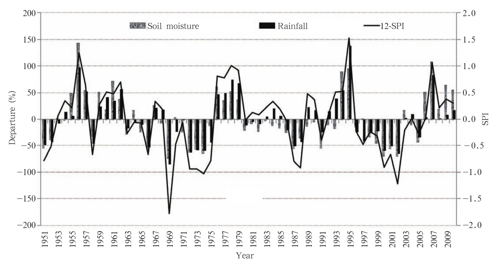
Fig.5.Temporal comparison among 12-month SPI and percentage departure of soil moisture and rainfall in Sindh Province during 1951-2010.
Figure 6 shows the relationship among percentage mean area deficit,50%quantile frequency,and 12-SPI in Sindh.The percentage mean area deficit increases with respect to SPI(tends to be negative),showing an inverse relationship between the two.The area deficit(%)increases due to negative values of SPI while positive values reduces this deficit(Wu et al.,2001).1969is an extreme drought year in the history of Sindh Province,where the lowest 12-SPI and soil moisture departure are observed(-50 and-90%).An abrupt change from a dry period to a wet period is observed in Sindh Province in the early 1990s,similar to what was observed in Hunan Province of China(Zhang et al.,2011).

Fig.6.Time series analysis among(a)50%quantile frequency,(b)mean area deficit(%),and(c)12-SPI of Sindh during 1951-2010.
Figure 7 shows the mean deficit(MD),mean area deficit(MAD),50%quantile frequency(QF),and 12-SPI along with the 5-yr moving average for the 60-yr period(1951-2010).There is an obvious relationship between the MD,MAD,and 50%quantile frequency deficit(QFD).Specifically,the 12-SPI is inversely proportional to MD(r=-0.61),MAD(r=-0.44),and QF(r=-0.62),which means that MD,MAD,and 50%QFD are in phase,while 12-SPI is out of phase with the other three variables.Therefore,the intensity of SPI(higher negative values)and time duration(3,6,9,12,and 24 months)increase with MAD and MD.
Isopleths were drawn relative to each station to identify the spatial association of rainfall over the 23 districts of Sindh for the period 1951-2010. Correlation coefficients were calculated for each of the other districts to determine the degree of correlation between the annual rainfall in each region.Figure 8 shows these coefficient isopleths with Shaheed Benazirabad in the center of Sindh as the base station,as suggested by Maher(1967). There is a significant correlation between annual rainfalls in the climate zone centered on the base station.Apart from the high correlation around the base station,the pattern for other stations shows a general east-south-east and east-north-east configuration,which is most likely associated with the normal paths of moving synoptic systems.The correlation patterns did not form circles,as might be anticipated,but were approximated by ellipses.The orientation of the axes of maximum and minimum correlations does not offer a means to trace the flux of atmospheric moisture or a means to identify its sources(Yevjevich,1967).This figure shows a high correlation among the 23 districts of Sindh,showing that all the districts receive rainfall,if a rainfall system approaches the base station.
The results from Mann-Kendall test for annual precipitation series show values that are statistically significant for Z>1.61 and Z >1.05 at the 95% and 90%confidence levels,respectively.The results showed no significant change at the 95%confidence level as demonstrated by Hanif et al.(2013).How-ever,a significant change was observed for the Jacobabad and Kashmore districts at the 90%confidence level.Table 2 shows a positive trend in the districts of Ghotki,Jacobabad,Kashmore,Larkana,Mirpurkhas,Sanghar,Sikarpur,Sukkur,Tharparkar,and Umerkot, and negative trends in the rest of the districts,representing almost non-significant conditions.The estimated Sen's slope(Q)shows the rising slope magnitude in the above-mentioned districts,although not a significant one.Sen's slope corresponds to Mann-Kendall test value and determines the increasing and decreasing trends and the magnitude of the slope(Mondal et al.,2012).The Student t-test and turning point test are found to be non-significant and random,respectively.
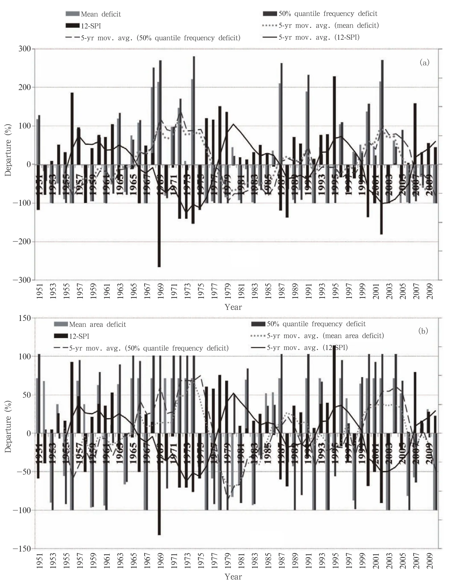
Fig.7.Comparison between 50%quantile frequency and 12-SPI of Sindh for(a)mean deficit(%)and(b)mean area deficit(%),based on time series analysis using a 5-yr moving average.

Fig.8.Correlation coefficient isopleths of annual rainfall between the base station Shaheed Benazirabad and other stations in the 23 districts of Sindh Province during 1951-2010.
Table 3 shows strong correlations between rainfall departures and SPI.The rainfall departure and SPI were taken on the same timescale,e.g.,3 months.Table 3 indicates that the correlation between the rainfall departure and SPI becomes stronger with the passage of time as indicated by Kumar et al.(2009).Drought intensity as a function of rainfall departure was also calculated,and the results are presented in Table 4.
The intensity and category of droughts were calculated from rainfall departure(%)on 3-,6-,9-,12-,and 24-month timescales by analyzing the data over 1951-2010 as shown in Table 4.The rainfall departure(%)is a simple tool for determining the intensity and category of drought.Long-term data(1951-2010)show that neither severe nor extreme droughts were observed based on 3-SPI,as drought intensity depends upon the length of the timescale.Table 4 is useful in monitoring and predicting the category and intensity of drought in Sindh.The analysis shows that Sindh is highly dependent on the monsoon rainfall,and rainfall deficiency during the monsoon season may lead to droughts.Hence,on the basis of monsoon rainfall de-parture,drought intensity can be monitored and predicted.The following four conditions are important for monitoring and predicting drought in Sindh.
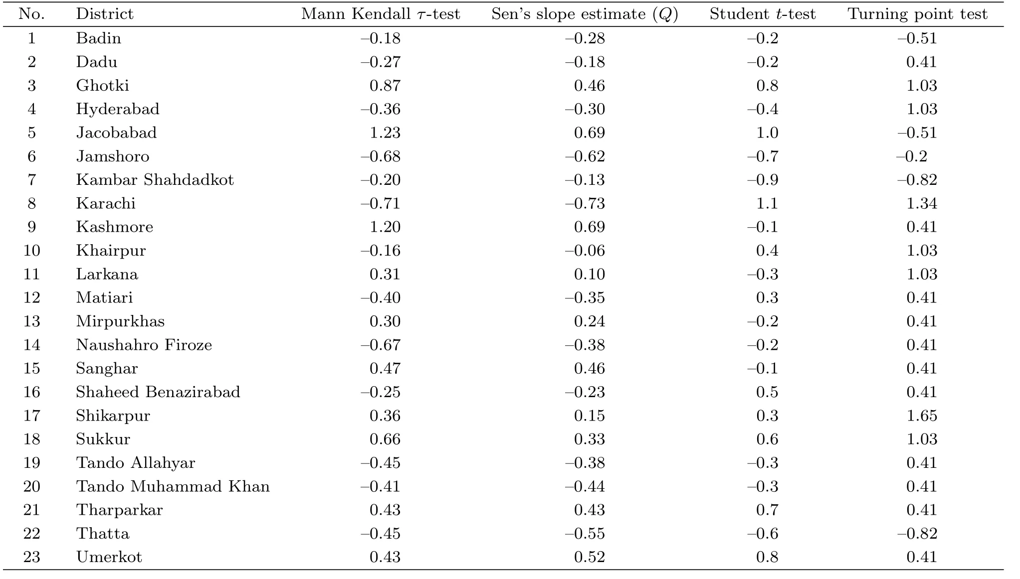
Table 2.Results from four different statistical tests for the 23 districts of Sindh
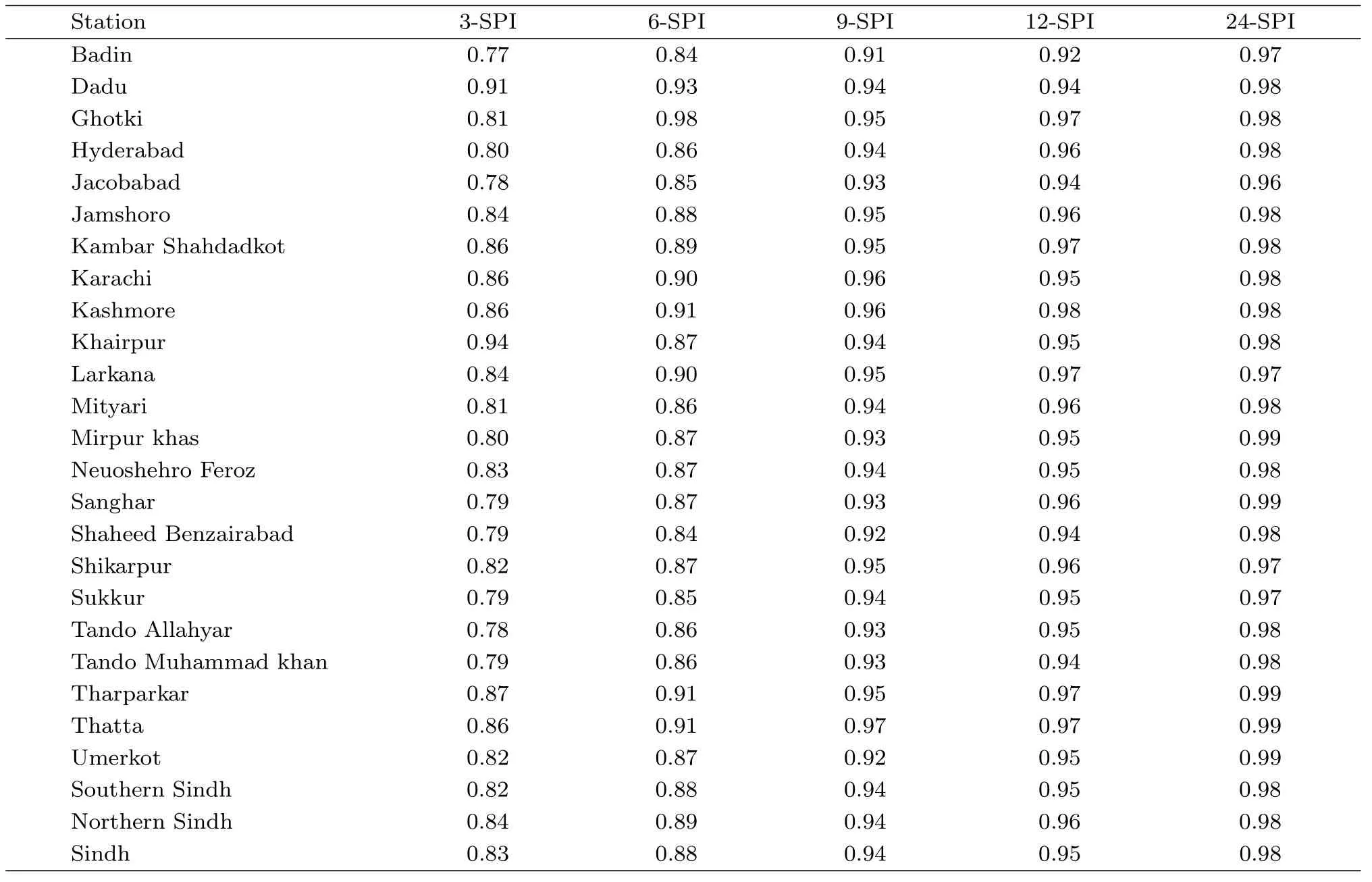
Table 3.Correaltion of rainfall departure with 3-,6-,9-,12-,and 24-SPI for Sindh districts

Table 4.Drought monitoring indicator for the Sindh region
1)If monsoon rainfall departure is more than -60%or the first two quarter departure is more than -50%,mild drought might occur;
2)If monsoon rainfall departure is more than -65%,or the first two quarter departure is more than -60%,or if monsoon rainfall departure exceeds-90%,or two quarter departure exceeds-90%,moderate drought might occur;
3)If monsoon rainfall departure is more than -75%and the first quarter departure is more than -85%,or if the monsoon rainfall departure is more than-90%and the first quarter departure is more than -60%,severe drought might occur;
4)If monsoon rainfall departure is more than -85%and two quarter departure is more than-95%, or if the monsoon rainfall departure is more than -90%and the first two quarter departure is more than -80%,extreme drought might occur.
Based on 3-SPI,high frequency of mild drought is observed in southern Sindh,while moderate drought frequently occurs in northern Sindh. Figure 9 depicts that neither severe nor extreme droughts were observed with 3-SPI.The total drought frequency is higher in northern Sindh than in southern Sindh,meaning that northern Sindh is more vulnerable to drought(mild to moderate),as compared to southern Sindh.
Based on 6-SPI (termed asmeteorological drought),Fig.10 indicates that the highest frequency of total droughts is observed in northern and southwestern parts of Sindh.Mild droughts are more frequent in northern parts,while moderate droughts are more frequent in central and southern parts of Sindh.Severe and extreme drought frequencies are higher in southern Sindh than in northern Sindh.Meteorological drought has higher frequency and less intensity in northern Sindh than in sourthern Sindh.Figure 10 shows that northern parts of Sindh are more vulnerable to meteorological droughts of mild to moderate intensity.

Fig.9.Drought frequency based on 3-SPI(dry period)of Sindh over 1951-2010.
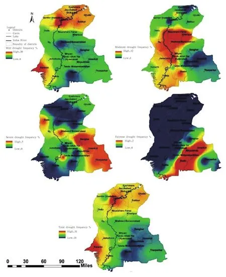
Fig.10.Drought frequency based on 6-SPI(meteorological drought)of Sindh over 1951-2010.
Based on 9-SPI(termed as agricultural drought),Fig.11 shows that the drought frequency(i.e.,mild to moderate and severe to extreme)is high in north-ern and southern parts of Sindh.The analysis also reveales that mild to moderate agricultural droughts are frequent in northern Sindh,while the intensity of these droughts is higher in southern Sindh.The total drought frequency is higher in northern Sindh than in southern Sindh.The northern Sindh receives less rain during the monsoon season than the southern part,which puts it at risk of agricultural drought.
According to climate normal of 1981-2010,the annual amount of rainfall is 128.7 mm in northernparts of Sindh and 209 mm in southern parts,which means that light to moderate deficiency of rainfall may cause drought in northern parts of Sindh.The 12-SPI indicates high frequencies of mild and extreme drought in southern parts of Sindh,but high frequencies of moderate and severe drought in the northern parts(Fig.12).The total drought frequency in northeastern and southwestern parts of Sindh is very high,suggesting that Sindh is highly susceptible to hydrological drought in the absence of monsoon rainfall.

Fig.11.Drought frequency based on 9-SPI(agriculture drought)of Sindh over 1951-2010.
Based on 24-SPI,Fig.13 shows high frequency of mild,moderate,and severe drought in Sindh,while extreme drought frequency is recorded only in the northern parts of Sindh.The total drought frequency insouthwestern parts of Sindh is very high.This implies that extreme hydrological drought is more frequent in that region.

Fig.12.Drought frequency based on 12-SPI(hydrological drought)of Sindh over 1951-2010.
The drought categories are defined on the basis of percentage of the affected area and intensity return period as shown in Table 5 for the Sindh region.
Each district is put into a category after the analysis of historical records during 1951-2010,as shown in Table 6.The most of the CAT-IV extreme droughts were observed in southern Sindh,where more than 80%of the area was affected.
Regional analysis in this study has identified thatthe two longest drought episodes are 1972-1974 and 2000-2002.According to SPI data,the most severe historical drought years are 1969,1974,1987,and 2002,where soil moisture departure(%)is below 50% in the entire province,as shown in Figs.14a and 14b.

Fig.13.Drought frequency based on 24-SPI(extreme hydrological drought)of Sindh during 1951-2010.

Table 5.Drought categories,percentage of area affected,and intensity return period for Sindh
The drought hazard map of Sindh Province(Fig. 15)has been prepared by considering the historical records(1951-2010)of following factors in the 23 districts:dependency on seasonal/monsoon rainfall,soil moisture,SPI to calculate the drought years,frequency,intensity,return period of drought,and percentage area affected by drought.The simplest equation to calculate the drought hazard index(DHI)is as follows:

where Tdis total number of droughts;Tyis total number of years;MIndexis monsoon rainfall index(see Table 7);SMJ-Dis soil moisture(July-December);and SMannualis annual soil moisture.
The drought vulnerability class limits and rating scores,obtained by taking the percentage of monsoon rainfall,are shown in Table 7.Based on the DHI equation(Eq.(1)),the severity class of vulnerability was developed,which varies from very low to extremely high values as describe by Asrari et al.(2012)(see Table 8).
与同区块近年来施工情况对比,东9-8、埕南91-平13、孤南24-斜91、滨5-斜45、桩59-斜40施工平均钻机月速达到了同井深、同类型施工井的最好水平,创下区块指标。
Figure 15 shows that the southern parts of Sindh are more vulnerable to droughts than the northern parts of Sindh.The Tharparkar district is highly dependent on monsoon rainfall and extremely vulnerable to drought(once every three years).The districts of Thatta,Badin,Tando Muhammad Khan,Tando Allahyar,Dadu,Mirpur Khas,Umerkot,Sanghar,and Shaheed Benazirabad(base station)are highly vul-nerable to drought as well.The western and eastern parts of Sindh districts(where no canal or river network is present)and the Kohistan region are also highly vulnerable to drought.
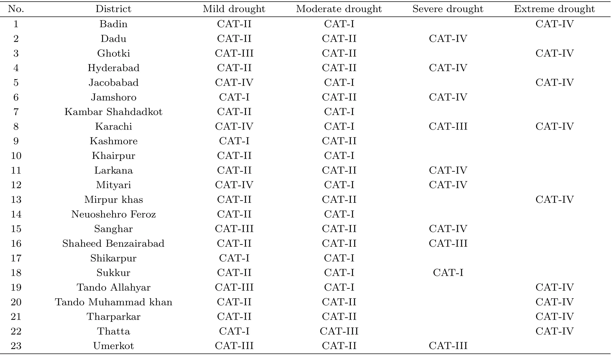
Table 6.Categories and intensity of drought prone districts of Sindh
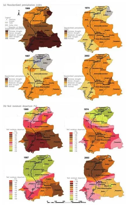
Fig.14.(a)SPI and(b)soil moisture departure(%)for the most severe historical drought years in Sindh.
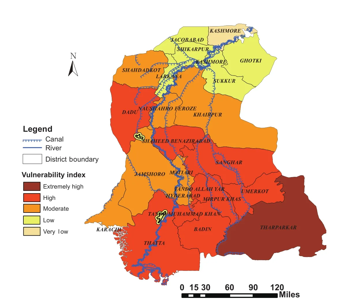
Fig.15.Drought hazard map showing the vulnerability index for each district of Sindh.
4.Summary
This study presents a full picture of the spatial distribution of drought and its characteristics over 23 districts of Sindh Province,Pakistan,based on SPI,soil moisture,and rainfall departure between 1951 and 2010.The results show a high correlation between the rainfall datasets of GPCC and meteorological station data,with R2values of 0.996 and 0.968,for both annual rainfall and monsoon season rainfall,respectively. A close relationship exists between the Mann Kendall and Sen's slope methods for statistical tests of the correlation results.
Annual and seasonal analyses show that no significant change(at the 95%confidence level)in precipitation was observed in Sindh.This region is highly dependent on monsoon rainfall(78.2%),and deficiency of monsoon rainfall is one of the major factors for the occurrence of drought.The southern part of Sindh is more vulnerable to drought than the northern part,as 82.1%of its rainfall is a result of monsoon rainfall. The drought climatologies of each district of Sindh Province are calculated on the basis of 3-,6-,9-,12-,and 24-SPI along with rainfall departure and soil moisture anomaly.The rainfall departure(%)has a strong correlation with SPI,and the correlation increases as time period increases.Rainfall departure is equally a good tool as SPI for determining the intensity and severity of droughts.The 5-yr moving average results show SPI to be inversely proportional to mean deficit,mean area deficit,and 50%quantile frequency deficit of rainfall.However,severity of drought was not significant on smaller timescales of SPI(≤3 months).Meteorological,agricultural,and hydrological droughts may be identified on 6-,9-and 12-SPI,respectively.
The frequency of mild droughts has increased in northern Sindh,while intense and severe droughts are reported in southern Sindh.Regional analysis of Sindh shows that the most severe historical droughts occu-rred in 1969,1974,1987,and 2002.In this study,a drought hazard map of Sindh was developed by considering the climatological records of drought. The district of Tharparkar is extremely vulnerable to drought.Thatta,Badin,Tando Muhammad Khan,Tando Allahyar,Dadu,Mirpur Khas,Umerkot,Sanghar,Shaheed Benazirabad,and Kohsitan districts are also highly vulnerable to drought.This study is useful to policy makers,water management and irrigation departments,and disaster management agencies for preparation of contingency plans regarding drought in drought-prone areas of the country as well as neighbouring countries.

Table 7.Criteria used for the hazard assessment of drought using percentage of normal rainfall

Table 8.The severity class used in the hazard map of Sindh
Acknowledgments.Theauthorssincerely thank Dr.Azmat Hayat Khan of National Drought Monitoring Centre of Pakistan,Mr.Mansoor Ahmed of PMD,GPCC,CPC,and the Department of Civil and Environmental Engineering,University of Catania.The authors appreciate the editors and the two anonymous referees for their positive remarks and insightful comments as well as suggestions.
Adnan,S.,2009:Agro-climatic Classification of Pakistan. Master dissertation,COMSATS Institute of Information Technology,Islamabad,Pakistan.[Accessed 29 October,2014][Available online at https://www.researchgate.net/publication/2617003 54-Agroclimatic-Classification-of-Pakistan].
Asrari,E.,M.Masoudi,and S.S.Hakimi,2012:GIS overlay analysis for hazard assessment of drought in Iran using Standardized Precipitation Index(SPI). J.Ecol.Field Bio.,35,323-329.
Becker,A.,P.Finger,A.Meyer-Christoffer,et al.,2013:A description of the global land-surface precipitation data products of the Global Precipitation Climatology Centre with sample applications including centennial(trend)analysis from 1901 to present. Earth System Science Data,5,71-99.
Cancelliere,A.,A.Ancarani,and G.Rossi,1998:Distribuzioni di probabilit`a delle caratteristiche di siccit`a. Atti del XXVI Conv. di Idr. e Costr. Idrauliche,Catania,Italy,9-12.
Dai,A.G.,2011:Drought under global warming:A review.Wiley Interdisciplinary Reviews:Climate Change,2,45-65.
Dai,A.G.,K.E.Trenberth,and T.T.Qian,2004:A global dataset of Palmer Drought Severity Index for 1870-2002:Relationship with soil moisture and effects of surface warming.J.Hydrometeor.,5,1117-1130.
Dracup,J.A.,K.S.Lee,and E.G.Paulson,Jr.,1980:On the definition of droughts.Water Resour.Res.,16,297-302.
EM-DAT,2013:The International Disaster Database,http://www.emdat.be/disaster-list,accessed on December 20,2014.
Fan,Y.,and H.Van Den Dool,2004:The CPC global monthly soil moisture data set at 0.5 degree resolution for 1948-present.J.Geophys.Res.,109,D10102,doi:10.1029/2003JD004345.
Fan,Y.,and H.Van Den Dool,2008:A global monthly land surface air temperature analysis for 1948-present. J.Geophys. Res.,113,D01103,doi:10.1029/2007JD008470.
Fern´andez,B.,and J.Salas,1999:Return period and risk of hydrologic events.Part I:Mathematical formulation.J.Hydro.Eng.,4,297-307.
Garcia-Herrera,R.,E.Hern´andez,D.Barriopedro,et al.,2007:The outstanding 2004/05 drought in the Iberian Peninsula:Associated atmospheric circulation.J.Hydrometeor.,8,483-498.
Giddings,L.,M.Soto,B.M.Rutherford,et al.,2005:Standardized precipitation index zones for Mexico. Atm´osfera,18,33-56.
Govement of Pakistan(GoP),2014:Economic Survey of Pakistan(2013-14),Ministry of Finance,Government of Pakistan,Islamabad,Pakistan,260 pp.
Guttman,N.B.,1994:On the sensitivity of sample L moments to sample size.J.Climate,7,1026-1029.
Hanif,M.,A.H.Khan,and S.Adnan,2013:Latitudinal precipitation characteristics and trends in Pakistan.J.Hydrol.,492,266-272,doi:10.1016/ j.jhydrol.2013.03.040.
Helsel,D.R.,and R.M.Hirsch,1992:Statistical Methods in Water Resources.Elsevier,Amsterdam,510 pp.
Huang,J.,H.M.Van Den Dool,and K.G.Georgakakos,1996:Analysis of model-calculated soil moisture over the US(1931-1993)and applications to longrange temperature forecasts.J.Climatol.,9,1350-1362.
Kogan,F.N.,1997:Global drought watch from space. Bull.Amer.Meteor.Soc.,78,621-636.
Kottegoda,N.T.,1980:Stochastic Water Resources Technology.The Macmillan Press,London,384 pp.
Kumar,M.N.,C.S.Muthly,M.V.R.Sesha,et al.,2009:On the use of Standardized Precipitation Index(SPI)for drought intensity assessment.Meteor. Appli.,16,381-389.
Kurnik,B.,P.Barbosa,and J.Vogt,2011:Testing two different precipitation datasets to compute the standardized precipitation index over the Horn of Africa. Int.J.Remote Sens.,32,5947-5964.
Liu Wenhuo,Gou Xiaohua,Yang Meixue,et al.,2009:Drought reconstruction in the Qilian Mountains over the last two centuries and its implications for largescale moisture patterns.Adv.Atmos.Sci.,26,621-629.
Maher,J.V.,1967:Drought assessment by statistical analysis of rainfall.Aust.NZ Assoc.Adv.Sci. Symp.Drought,Melbourne,57-71.
Maidment,D.R.,1993: HandbookofHydrology. McGraw-Hill Inc.,New York,1424 pp.
Marengo,J.A.,J.Tomasella,L.M.Alves,et al.,2011:The drought of 2010 in the context of historical droughts in the Amazon region. Geophys. Res. Lett.,38,doi:10.1029/2011GL047436.
McKee,T.B.,N.J.Doeskin,and J.Kleist,1993:The relationship of drought frequency and duration to timescales.Proceedings of the 8th Conference on Applied Climatology.American Meteorological Society,Boston,MA,179-184.
Mishra,A.K.,and V.P.Singh,2010:A review of drought concepts.J.Hydrol.,391,202-216.
Mondal,A.,S.Kundu,and A.Mukhopadhyay,2012:Case study rainfall trend analysis by Mann-Kendall test:Case study of north-eastern part of Cuttack district,Orissa. Int. J.Geology Earth Environ. Sci.,2,70-78.[Accessed 29 July,2014][Available online at http://www.cibtech.org/jgee.htm].
Muslehuddin,M.,and N.Faisal,2006:Long range forecast of Sindh monsoon. Pakistan J.Meteor.,3,35-44.
Muslehuddin,M.,H.Mir,and N.Faisal,2005:Sindh Summer(June-September)monsoon rainfall prediction.Pakistan J.Meteor.,2,91-108.
Narendra,B.H.,2008:Drought monitoring using rainfall data and spatial soil moisture modeling.Master dissertation,Gadja Mada University,India,75 pp.
Pakistan Meteorological Department(PMD),2013:Climatic Normal(1981-2010)of Pakistan.Karachi,48-58.
Pietzsch,S.,and P.Bissolli,2011:A modified drought index for WMO RA VI.Adv.Sci.Res.,6,275-279.
Raziei,T.,I.Bordi,and L.S.Pereira,2011:An application of GPCC and NCEP/NCAR datasets for drought variability analysis in Iran. Water Resources Management,25,1075-1086.
Rossi,G.,and A.Cancelliere,2003:At-site and regional drought identification by ReDIM model. Tools for Drought Mitigation in Mediterranean Regions. Springer,Kluwer Academic Publishing,Netherland,37-54.
Rouault,M.,and Y.Richard,2003:Intensity and spatial extension of drought in South Africa at different timescales.Water SA,29,489-500.
Sen,P.K.,1968:Estimates of the regression coefficient based on Kendall's tau.J.Amer.Statis.Assoc.,63,1379-1389.
Sheffield,J.,E.F.Wood,and M.L.Roderick,2012:Little change in global drought over the past 60 years. Nature,491,435-438.
Spinoni,J.,G.Naumann,H.Carrao,et al.,2014:World drought frequency,duration,and severity for 1951-2010. Int. J.Climatol.,34,2792-2804. doi:10.1002/joc.3875.
Svoboda,M.,D.Lecomte,M.Hayes,et al.,2002:The drought monitor.Bull.Amer.Meteor.Soc.,83,1181-1190.
United Nations Environment Programme(UNEP),1998:Land Cover Assessment and Monitoring.Pakistan,10-A,UNEP/EAP.TR/95-06,50 pp.
Vogt,J.V.,U.Safriel,G.Von Maltitz,et al.,2011:Monitoring and assessment of land degradation and desertification:Towards new conceptual and integrated approaches.Land Degradation&Development,22,150-165.
Vogt,J.V.,and F.Somma,2013:Drought and Drought Mitigation in Europe.Springer Science&Business Media,328 pp.
Wilhite,D.A.,2012:Drought Assessment,Management,and Planning:Theory and Case Studies.Springer Science&Business Media,262 pp.
Wilhite,D.A.,and M.H.Glantz,1985:Understanding:The drought phenomenon:The role of definitions. Water International,10,111-120.
World Meteorological Organization,2012: Standardized Precipitation Index User Guide.M.Svoboda,M.Hayes,and D.Wood,Eds.,WMO-No.1090,Geneva,24 pp.
Wu,H.,M.J.Hayes,A.Weiss,et al.,2001:An evaluation of the standardized precipitation index,the China-Z-index and the statistical Z-score.Int.J. Climatol.,21,745-758,doi:10.1002/joc.658.
Yevjevich,V.,1967:An Objective Approach to Definitions and Investigations of Continental Hydrologic Drought.Colorado State University,Fort Collins,Colorado,18 pp.
Zeng,N.,2003:Drought in the Sahel.Science,302,999-1000,doi:10.1126/science.1090849.
Zhang Jianming,Zhang Xinping,Li Zuxian,et al.,2011:Spatial distribution and variation tendency of droughts and floods in Hunan Province during the past 36 years.J.Tropical Meteor.,17,385-391.
Zheng,Y.C.,2000:Summaries of natural disasters across the globe.J.Dis.Reduc.,10,14-19.(in Chinese)
Shahzada Adnan,Kalim Ullah,and Gao Shouting,2015:Characterization of drought and its assessment over Sindh,Pakistan during 1951-2010.J.Meteor.Res.,29(5),837-857,
10. 1007/s13351-015-4113-z.
(Received December 27,2014;in final form July 27,2015)
猜你喜欢
杂志排行
Journal of Meteorological Research的其它文章
- Interannual Variability of the Wintertime Northern Branch High Ridge in the Subtropical Westerlies and Its Relationship with Winter Climate in China
- Analysis of Tibetan Plateau Vortex Activities Using ERA-Interim Data for the Period 1979-2013
- A Piecewise Modeling Approach for Climate Sensitivity Studies:Tests with a Shallow-Water Model
- Characteristics and Mechanisms of the Sudden Warming Events in the Nocturnal Atmospheric Boundary Layer:A Case Study Using WRF
- A New Evaporation Duct Climatology over the South China Sea
- Cloud Radiative Forcing Induced by Layered Clouds and Associated Impact on the Atmospheric Heating Rate
