土地利用方式影响下的赣江硝态氮浓度和氮稳定同位素分布特征*
2015-03-20齐述华
王 鹏,齐述华,陈 波
(1:江西师范大学鄱阳湖湿地与流域研究教育部重点实验室,南昌 330022;2:江西师范大学地理与环境学院,南昌 330022 ;3:中国科学院陆地水循环及地表过程重点实验室,北京 100101)
土地利用方式影响下的赣江硝态氮浓度和氮稳定同位素分布特征*
王 鹏1,2,3,齐述华1,2,陈 波1,2
(1:江西师范大学鄱阳湖湿地与流域研究教育部重点实验室,南昌 330022;2:江西师范大学地理与环境学院,南昌 330022 ;3:中国科学院陆地水循环及地表过程重点实验室,北京 100101)

赣江;鄱阳湖;硝态氮;氮稳定同位素;土地利用

1 材料与方法
1.1 样品采集与分析

图1 赣江流域采样点与子流域划分(S1~S20表示采样点,Z1~Z20表示相应子流域)Fig.1 Sample sites and sub basins in Ganjiang Basin (S1-S20 represent sample sites, and Z1-Z20 represent sub basins)
1.2 子流域与土地利用类型
对S1~S20采样点,基于Aster 30m精度的DEM数据,利用ArcGIS的Hydrology模块划分采样点对应的子流域,相应划分为20个子流域.土地利用数据利用2010年秋季获取的无云Landsat卫星遥感影像,经过几何纠正,参照《环境状况评价技术规范》(HJ/T 192-2006)中土地利用分类方法,基于ArcInfo Workstation,并结合人工目视解译获得.该土地利用体系的一级分类划分为林地、草地、居民建设用地、水域、旱地、水田和未利用地共7种类型,根据地形地貌、林地郁闭度和草地覆盖度等条件建立二级分类体系(图2).该数据库经过内业校核和外业核查,一级分类的总体精度达到90%以上,二级分类精度大于85%.
1.3 数据分析
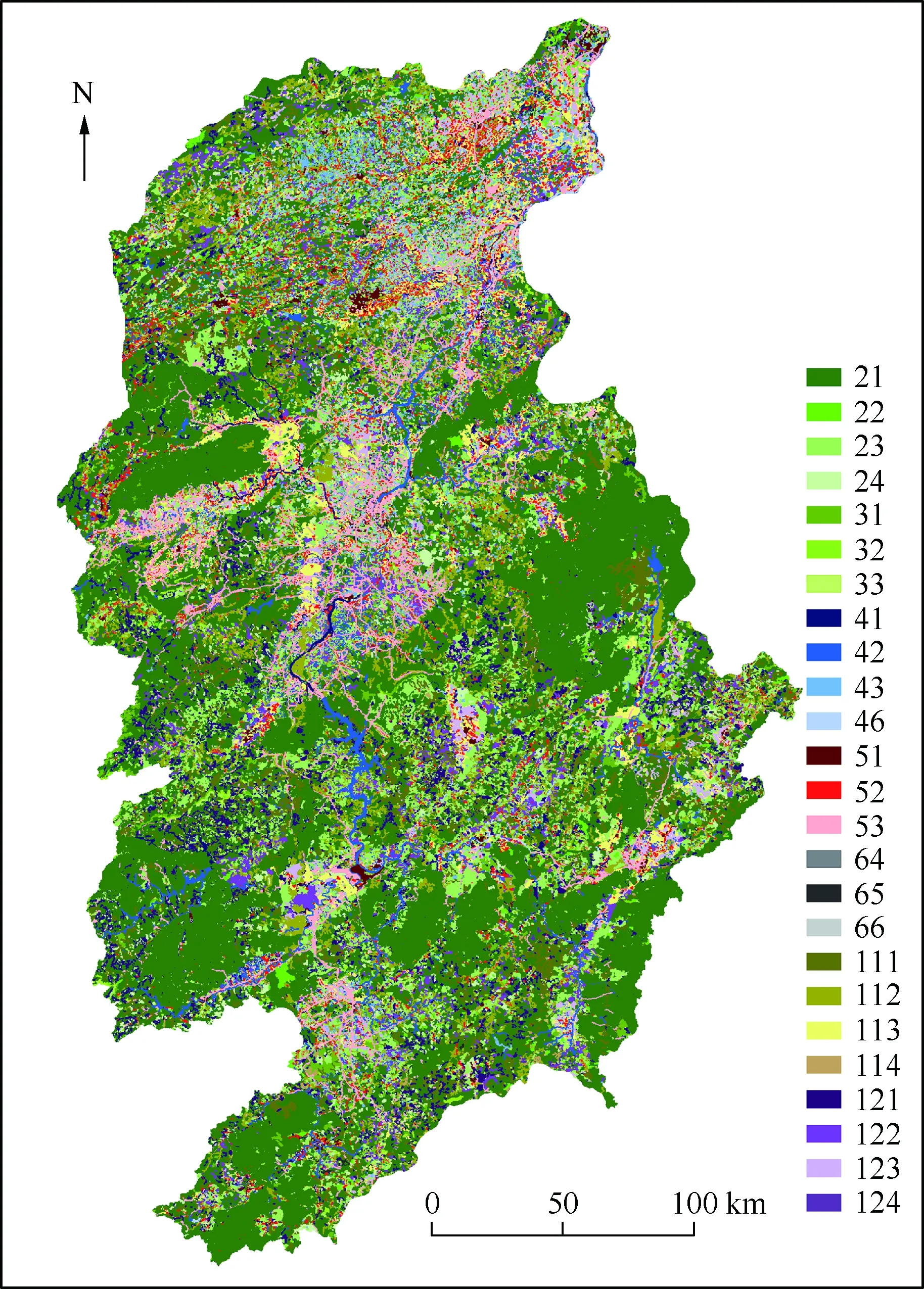
图2 赣江流域土地利用类型(图例代码见表1)Fig.2 Land use patterns in Ganjiang Basin(Legend code are shown in table 1)

一级分类(代码)二级分类(代码)水田山区水田(111);丘陵水田(112);平原水田(113);大于25°坡地水田(114)旱地山区旱地(121);丘陵旱地(122);平原旱地(123);大于25°坡地旱地(124)林地 有林地(21):郁闭度>50%的天然林和人工林;灌木林(22):郁闭度>40%、高度在2m以下的矮林地和灌丛林地;疏林地(23):郁闭度为10%~30%;其它林地(24):未成林造林地、迹地、苗圃及各类园地草地 高覆盖度草地(31):覆盖度>50%;中覆盖度草地(32):覆盖度20%~50%;低覆盖度草地(33):覆盖度5%~20%水域河渠(41);湖泊(42);水库坑塘(43);滩地(46)居民建设用地城镇用地(51);农村居民用地(52);其它工矿建设用地(53)未利用土地沼泽地(64);裸土地(65);裸岩石砾地(66)
1) 将采样点控制的子流域分为相邻控制流域和总控制流域2种空间尺度.相邻控制流域指从某采样点至上游相邻采样点间的流域汇水范围,总控制流域指某采样点在赣江流域内总的流域汇水范围.如S3的相邻控制流域为Z3,总控制流域为Z1+Z2+Z3.
2 结果

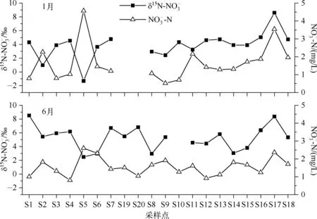
图3 赣江浓度和值的分布(S19和S20点位只在6月采集,S10点位6月没有检测出值)
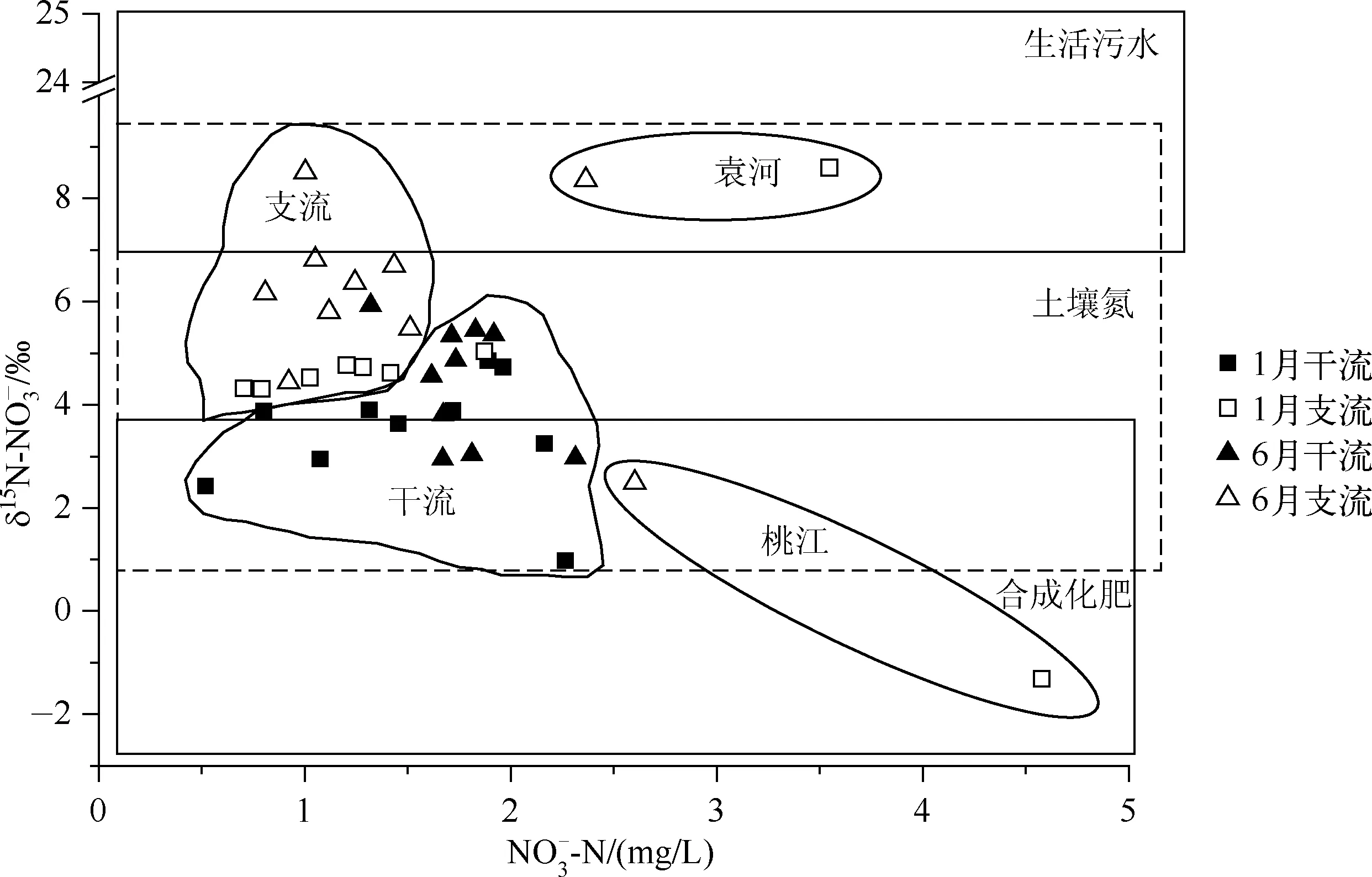
图4 赣江浓度和值的关系(生活污水、土壤氮和合成化肥的15N取值范围参考文献[19-20])(Ranges of 15N for domestic sewage, soil N and fertilizer are taken from references[19-20])
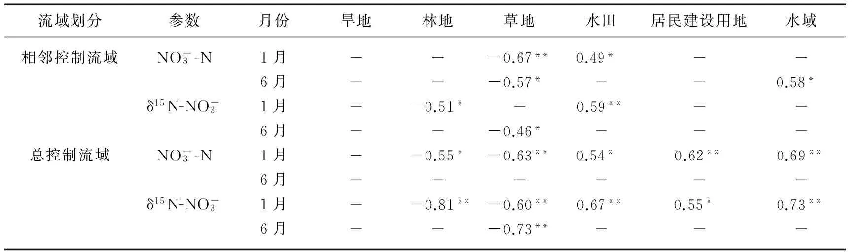
流域划分参数月份旱地林地草地水田居民建设用地水域相邻控制流域NO-3-N1月-0.67**0.49* 6月-0.57*0.58* δ15N-NO-31月-0.51*0.59**6月-0.46*总控制流域NO-3-N1月-0.55*-0.63**0.54* 0.62**0.69**6月δ15N-NO-31月-0.81**-0.60**0.67**0.55* 0.73**6月-0.73**
**表示在0.01水平(双侧)上显著相关,*表示在0.05水平(双侧)上显著相关,下同.
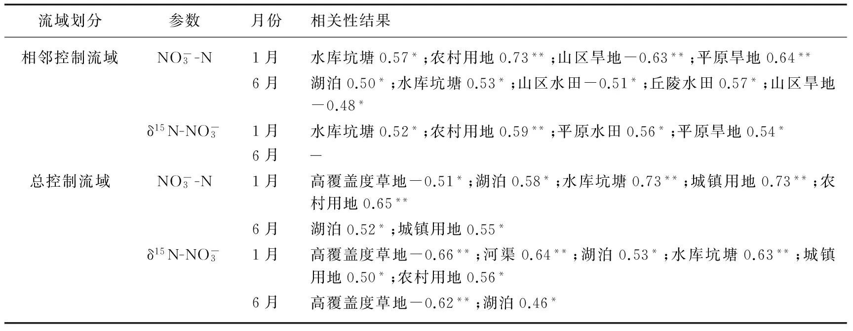
流域划分参数月份相关性结果相邻控制流域NO-3-N1月水库坑塘0.57*;农村用地0.73**;山区旱地-0.63**;平原旱地0.64**6月 湖泊0.50*;水库坑塘0.53*;山区水田-0.51*;丘陵水田0.57*;山区旱地-0.48*δ15N-NO-31月水库坑塘0.52*;农村用地0.59**;平原水田0.56*;平原旱地0.54*6月总控制流域 NO-3-N 1月 高覆盖度草地-0.51*;湖泊0.58*;水库坑塘0.73**;城镇用地0.73**;农村用地0.65**6月湖泊0.52*;城镇用地0.55*δ15N-NO-3 1月 高覆盖度草地-0.66**;河渠0.64**;湖泊0.53*;水库坑塘0.63**;城镇用地0.50*;农村用地0.56*6月高覆盖度草地-0.62**;湖泊0.46*
3 讨论
4 结论
致谢:本研究的同位素分析实验得到中国科学院遗传与发育生物学研究所的研究生赵焕、孔晓乐和梁慧雅的帮助,在此表示感谢.
[1] Mcisaac GF, David MB, Gertner GZetal. Eutrophication: Nitrate flux in the Mississippi River. 2001, 414(6860): 166-167.
[2] Townsend-Small A, Mccarthy MJ, Brandes JAetal. Stable isotopic composition of nitrate in Lake Taihu, China, and major inflow rivers.Hydrobiologia, 2007, 194: 135-140.
[3] 余进祥,刘娅菲,钟晓兰等.鄱阳湖水体富营养化评价方法及主导因子研究.江西农业学报,2009,21(4):125-128.
[4] 陈晓玲,张 媛,张 琍等.丰水期鄱阳湖水体中氮、磷含量分布特征.湖泊科学,2013,25(5):643-648.DOI 10.18307/2013.0504.
[5] Wu Z, Cai Y, Liu Xetal. Temporal and spatial variability of phytoplankton in Lake Poyang: The largest freshwater lake in China.JournalofGreatLakesResearch, 2013, 39(3): 476-483.
[6] 刘倩纯,余 潮,张 杰等.鄱阳湖水体水质变化特征分析.农业环境科学学报,2013,(6):1232-1237.
[7] 王毛兰,周文斌.鄱阳湖水体无机氮时空分布特征研究.人民长江,2010,41(1):88-91.
[8] 王毛兰,周文斌,胡春华.赣江流域水体无机氮分布特征.南昌大学学报:理科版,2007,31(3):271-275.
[9] 王毛兰,胡春华,周文斌.丰水期鄱阳湖氮磷含量变化及来源分析.长江流域资源与环境,2008,17(1):138-142.
[10] Ohte N, Dahlgren RA, Silva SRetal. Sources and transport of algae and nutrients in a Californian river in a semi-arid climate.FreshwaterBiology, 2007, 52(12): 2476-2493.
[11] 陈法锦,李学辉,贾国东.氮氧同位素在河流硝酸盐研究中的应用.地球科学进展,2007,(12):1251-1257.
[12] Kendall C. Tracing nitrate sources and cycling in catchments. In:Kendall C, McDonnell JJ eds.Isotope tracers in catchment hydrology. Amsterdam:Elsevier, 1998: 519-576.
[13] Bedard-Haughn A, Van Groenigen JW, Van Kessel C. Tracing N through landscapes: potential uses and precautions.JournalofHydrology, 2003, 272(1/2/3/4): 175-190.
[14] Voss M, Deutsch B, Elmgren Retal. Source identification of nitrate by means of isotopic tracers in the Baltic Sea catchments.Biogeosciences, 2006, 3(4): 663-676.
[15] Ide J, Somura H, Nakamura Tetal. Hydrological effects on relationships between δN of river nitrate and land use in a rural river basin, western Japan.RiverResearchandApplications, 2014. DOI: 10.1002/rra.2756.
[16] 王开然,郭 芳,姜光辉等.N和O在桂林岩溶水氮污染源示踪中的应用.中国环境科学,2014,34(9):2223-2230.
[17] 向速林.赣江流域农田地表径流氮磷迁移与流失研究.生态环境学报,2013,22(7):1204-1207.
[18] Silva S R, Kendall C, Wilkison DHetal. A new method for collection of nitrate from fresh water and the analysis of nitrogen and oxygen isotope ratios.JournalofHydrology,2000, 228(1/2): 22-36.
[19] Nestler A, Berglund M, Accoe Fetal. Isotopes for improved management of nitrate pollution in aqueous resources: review of surface water field studies.EnvironmentalScienceandPollutionResearch, 2011, 18(4): 519-533.
[20] Xue D, Botte J, De Baets Betal. Present limitations and future prospects of stable isotope methods for nitrate source identification in surface-and groundwater.WaterResearch, 2009, 43(5): 1159-1170.
[21] 罗 璇,史志华,尹 炜等.小流域土地利用结构对氮素输出的影响.环境科学,2010,31(1):58-62.
[22] Bu H, Meng W, Zhang Yetal. Relationships between land use patterns and water quality in the Taizi River basin, China.EcologicalIndicators, 2014, 41: 187-197.
[23] 孙然好,陈利顶,王 伟等.基于“源”“汇”景观格局指数的海河流域总氮流失评价.环境科学,2012,33(6):1784-1788.
[24] 李兆富,杨桂山,李恒鹏.西苕溪典型小流域土地利用对氮素输出的影响.中国环境科学,2005,25(6):678-681.
[25] Nielsen A, Trolle D, Sndergaard Metal. Watershed land use effects on lake water quality in Denmark.EcologicalApplications, 2012, 22(4): 1187-1200.
[26] Xue D, De Baets B, Van Cleemput Oetal. Use of a Bayesian isotope mixing model to estimate proportional contributions of multiple nitrate sources in surface water.EnvironmentalPollution, 2012, 161: 43-49.
[27] Smith EL, Kellman LM. Examination of nitrate concentration, loading and isotope dynamics in subsurface drainage under standard agricultural cropping in Atlantic Canada.JournalofEnvironmentalManagement, 2011, 92(11): 2892-2899.
[28] 陈惟财,陈伟琪,张珞平等.九龙江流域地表水中硝酸盐来源辨析.环境科学,2008,29(6):1484-1487.
[29] Johannsen A, Dähnke K, Emeis K. Isotopic composition of nitrate in five German rivers discharging into the North Sea.OrganicGeochemistry, 2008, 39(12): 1678-1689.
[30] 赵中华,邱祖民.桃江流域农业区氮平衡及时空差异性.水电能源科学,2012,30(5):83-86.
[31] Li S, Liu C, Li Jetal. Assessment of the sources of nitrate in the Changjiang River, China using a nitrogen and oxygen isotopic approach.EnvironmentalScience&Technology, 2010, 44(5): 1573-1578.
[32] 徐刘凯,王全金,向速林等.赣江下游地区各类非点源污染源的影响研究.华东交通大学学报,2012,(1):48-53.
[33] 王毛兰,赖建平,胡珂图等.鄱阳湖表层沉积物有机碳、氮同位素特征及其来源分析.中国环境科学,2014,34(4):1019-1025.
Characteristics of nitrate and nitrogen stable isotope in Ganjiang River under the influence of land use
WANG Peng1,2,3, QI Shuhua1,2& CHEN Bo1,2
(1:KeyLaboratoryofPoyangLakeWetlandandWatershedResearch,MinistryofEducation,JiangxiNormalUniversity,Nanchang330022,P.R.China2:SchoolofGeographyandEnvironment,JiangxiNormalUniversity,Nanchang330022,P.R.China3:KeyLaboratoryofWaterCycleandRelatedLandSurfaceProcesses,ChineseAcademyofSciences,Beijing100101,P.R.China)
Identifying the source of nitrate in the Ganjiang River has great significance to eutrophication control in the Lake Poyang,since the nitrate in the Ganjiang River is the main source of nitrogen input into the lake. Based on the investigation of NO -3 -N andδ15N-NO -3 in the mainstream and major tributaries of the Ganjiang River in January and June of 2013,the characteristics of nitrateand nitrogen stable isotope and the influence from land use were analyzed through different spatial scales and classification levels.The ranges of NO -3 -N concentration in dry season and wet season were 0. 52 - 4. 58 mg /L and 0. 81-2. 60 mg /L,respectively,andtheir mean value had no significant difference between the two seasons. The ranges of δ15N-NO -3 in dry season and wet season were- 1. 31‰-8. 60‰ and 2. 49‰-8. 51‰,respectively,which were significantly lower in dry season. Land use with larger spatialscales had more significant correlation with NO -3 -N and δ15N-NO -3 . The NO -3 -N concentration and δ15N-NO -3 in Gangjiang Riverwere significantly positively correlated with the area of paddy field,residential land and water,and significantly negatively correlated with the area of forest land and grass land. However,this correlation decreased in wet season. Compared to the first level of land use classification,the second level of land use classification was more helpful to reflect the correlation of land use with NO -3 -N,while little help for δ15N-NO -3 . Agricultural land,especially hill paddy field and plain dry land,was the main source of NO -3 -N. Compared with other area in the Yangtze River Basin,there was a smaller proportion of NO -3 -N coming from domestic sewage in the Ganjiang River Basin.
Ganjiang River; Lake Poyang; nitrate; nitrogen stable isotope; land use
J.LakeSci.(湖泊科学), 2015, 27(6): 1011-1019
DOI 10.18307/2015.0604
©2015 byJournalofLakeSciences
国家自然科学基金项目(41201033)、鄱阳湖湿地与流域研究教育部重点实验室主任开放基金项目(ZK2013009)、中国科学院陆地水循环及地表过程重点实验室开放基金项目(WL2013004)和江西省重大生态安全问题监控协同创新中心项目(JXS-EW-00)联合资助.
2014-12-19收稿;2015-02-11收修改稿.
王鹏(1982~),男,博士,副教授;E-mail:wangpengjlu@gmail.com.