Variations in Regional Mean Daily Precipitation Extremes and Related Circulation Anomalies over Central China During Boreal Summer
2014-12-14KEDan柯丹andGUANZhaoyong管兆勇
KE Dan(柯丹)and GUAN Zhaoyong(管兆勇)
Key Laboratory of Meteorological Disasters of China Ministry of Education,Nanjing University of Information Science&Technology,Nanjing 210044
Variations in Regional Mean Daily Precipitation Extremes and Related Circulation Anomalies over Central China During Boreal Summer
KE Dan(柯丹)and GUAN Zhaoyong∗(管兆勇)
Key Laboratory of Meteorological Disasters of China Ministry of Education,Nanjing University of Information Science&Technology,Nanjing 210044
The variations of regional mean daily precipitation extreme(RMDPE)events in central China and associated circulation anomalies during June,July,and August(JJA)of 1961-2010 are investigated by using daily in-situ precipitation observations and the NCEP/NCAR reanalysis data.The precipitation data were collected at 239 state-level stations distributed throughout the provinces of Henan,Hubei,and Hunan. During 1961-2010,the 99th percentile threshold for RMDPE is 23.585 mm day-1.The number of RMDPE events varies on both interannual and interdecadal timescales,and increases significantly after the mid 1980s. The RMDPE events happen most frequently between late June and mid July,and are generally associated with anomalous baroclinic tropospheric circulations.The supply of moisture to the southern part of central China comes in a stepping way from the outer-region of an abnormal anticyclone over the Bay of Bengal and the South China Sea.Fluxes of wave activity generated over the northeastern Tibetan Plateau converge over central China,which favors the genesis and maintenance of wave disturbances over the region.RMDPE events typically occur in tandem with a strong heating gradient formed by net heating in central China and the large-scale net cooling in the surrounding area.The occurrence of RMDPE events over central China is tied to anomalous local cyclonic circulations,topographic forcing over the northeast Tibetan Plateau,and anomalous gradients of diabatic heating between central China and the surrounding areas.
regional mean daily precipitation extreme event,circulation anomalies,wave activity flux,central China,boreal summer
1.Introduction
An increasing amount of attention has been paid to precipitation extreme events in recent decades.A recent IPCC report(IPCC,2012)on climate extremes indicated that the frequency of strong rainfall events and the proportion of intensive rainfall to total rainfall may increase in many areas of the world under global warming.This hypothesis is supported by a number of primary studies(Karl and Knight,1998;Stone et al., 1999;Yamamoto and Sakurai,1999).The intensity and frequency of rainfall may increase even in regions where the total rainfall remains constant or decreases (Buffoni et al.,1999;Groisman et al.,1999;Kunkel et al.,1999;Easterling et al.,2000;Manton et al.,2001). Trends in the frequency of extreme rainfall in China differ substantially by region and season,while trends in total annual rainfall depend primarily on trends in the occurrence of extreme rainfall events(Zou et al., 2009).Regional trends and variations are not necessarily consistent with global trends and variations.
Daily precipitation extremes(DPE)in China typically take place south of 35°N,particularly over the mid-low reaches of the Yangtze River,the area imme-
diately south of the Yangtze River(the Jiangnan region),and the southeastern Tibetan Plateau. Regional mean daily precipitation extreme(RMDPE) events,which can persist for longer time,are also relatively frequent over these regions(Wang and Qian, 2009).Research on interdecadal variations in torrential rainfall indicates that the frequency of extreme precipitation events has decreased significantly in recent decades over North China and the Sichuan basin, but has increased significantly over West China,the Yangtze River valley,and coastal areas of Southeast China(Zhai et al.,1999a,b;Zhai and Pan,2003;Bao and Huang,2006).
Supported by the National Natural Science Foundation of China(41330425)and China Meteorological Administration Special Public Welfare Research Fund(GYHY201406024).
∗Corresponding author:guanzy@nuist.edu.cn.
©The Chinese Meteorological Society and Springer-Verlag Berlin Heidelberg 2014
Extreme precipitation events take place mainly during summer and are generally of short duration. The frequency of such extreme events has increased over the Yangtze River basin and decreased over northern China in recent decades(Wang and Zhou,2005). RMDPE events lasting for two days or less are most common over the mid-low reaches of the Yangtze River valley and the Jiangnan region,while RMDPE events lasting three days or more occur predominantly over the southeast coast,the southeast Tibetan Plateau, and the western part of the Yun-Gui Plateau(Wang and Qian,2009).The area impacted by summer floods south of the Qinling Mountains-Huai River has increased over the past 50 years.This increase was particularly strong during the 1990s(Wang et al.,2005); however,recent studies indicate slight reductions in the intensity and frequency of summer DPE events over the mid-low reaches of the Yangtze River valley during the early 21st century(Zou et al.,2009;He et al.,2013).
Weathers underlying RMDPE events fall largely into two classes:rainstorms and floods.It is generally believed that many torrential rain events originate as meso-β weather systems.The physical mechanisms behind the occurrence and development of these systems are extremely complicated as the systems are heavily localized and develop very rapidly.So far, the scientific understanding of meso-β rainstorms is still not sufficient enough for reliable forecasting(Bei and Zhao,2002;Wang and Li,2002;Xu et al.,2008). Many studies have examined the formation mechanisms of large-scale droughts and floods,such as the attribution of the 1998 Yangtze basin floods to ENSO (Huang et al.,1998;Sun and Ma,2001)and baroclinic wave activity at upper levels(Mei and Guan, 2009).Most studies on RMDPE have focused on the long-term trends or small-scale events(Guan and Ren, 2012);relatively few studies have examined RMDPE events with regional or large-scale coverage(Guan et al.,2011).
Central China is one of the most important region with dense population and quick economical development.This region is located to the east of the Tibetan Plateau,where cold air from the north and warm air from the south converge at lower levels.RMDPE events can cause severe flooding in central China,with serious impacts on industrial activity,agricultural productivity,and daily lives of the human population. Torrential rain events that occur at low frequency but with high intensity and long duration are very likely to produce large-scale floods(Xiao et al.,2010).Examples include the 4-day rainstorm over Lake Dongting valley in July 1996(Zhang et al.,2004),the 10-day rain event over the Jiangnan region in June 1998(National Climate Center,1998),and the 9-day rain event over the mid-lower Yangtze basin in June 1999(Zhang et al.,2001).All of these rain events had serious socioeconomic consequences.
Central China covers an extensive area in the north-south direction with complex topography and climate regime. Scientists in each of the three provinces(Henan,Hubei,and Hunan)of central China have conducted studies on the characteristics of rainfall in their own provinces(Qin and Wang,1997;Jiao and Kang,2007;Zhang et al.,2008)and in central China as a whole(Chen et al.,2010;Sun et al.,2010; Ren et al.,2013).The exceptional flood that occurred in the Yangtze River basin in 1998 was investigated by many research groups(e.g.,Huang et al.,1998;Ren et al.,2000;Mei and Guan,2009),demonstrating some complicated features in circulation anomalies related to both the anomalous sea surface temperature in the tropics and the Rossby wave activities in midlatitudes. Guan et al.(2011)showed that different patterns of Pacific sea surface temperature anomalies(SSTA)are
likely to have a considerable influence on the occurrence of RMDPE events in the Yangtze River basin. However,little efforts have been made to identify and attribute the causes of regional rainfall extremes over central China.Therefore,we examine in the present paper the variations of summertime RMDPE events over central China during 1961-2010 using in situ precipitation observations from 239 stations and daily meteorological data from the NCEP/NCAR reanalysis. The results that explore the features and causes of summer RMDPE events over central China will help to advance our understanding of the mechanisms of weather and climate variations in this region and to improve disaster prevention and mitigation efforts.
2.Data and methods
2.1 Data
This work is based on daily rainfall observations from 239 stations within central China between 1961 and 2010,as well as historical records from the archives of Henan,Hubei,and Hunan provinces.Of the 239 stations with complete data records between 1961 and 2010,97 are located in Henan,67 in Hubei,and 75 in Hunan. Meteorological variables and related physical quantities are taken from the NCEP/NCAR daily reanalysis(Kistler et al.,2001)at a horizontal resolution of 2.5°×2.5°.Typhoons over central China are identified using the Optimal Tropical Cyclone Paths Atlas released by the China Meteorological Administration(CMA)(http://tcdata.typhoon. gov.cn/zjljsjj-zlhq.html). Summer comprises June, July,and August(JJA).
2.2 Methods
A number of techniques for testing the homogeneity of rainfall data have been developed in recent years, including the standard normal homogeneity technique (SNHT)and the Buishand method.SNHT is a parameter verification technique for judging the inhomogeneity of a time series against a reference time series,and can be used to detect sudden shifts or linear trends(Hawkins,1977;Li et al.,2008).The Buishand method is based on the sum of departures from the mean of the time series(Wijngaard et al.,2003). We also use a two-term regression(Solow,1987),the Pettitt scheme(Pettitt,1979),and multivariate linear regression to analyze the precipitation data.These five tests are used as the criteria for selecting statistically significant station data at the 99%confidence level.Stations with annual total rainfall time series that pass at least three of the five statistical tests are selected for further study.These criteria are met for 233 of the 239 stations.
The stations in central China that meet our selection criteria are distributed densely and approximately homogeneously.We therefore use a simple arithmetic average to represent the regional mean:

where Pridenotes daily mean rainfall at the ith station.
We investigate the causes of RMDPE events by computing vertically integrated water vapor fluxes,apparent heat sources,and apparent water vapor sinks. Water vapor fluxes are calculated as

where q is specific humidity,psis surface pressure,and V is the horizontal wind vector.The apparent heat source Q1and the apparent vapor sink Q2are calculated as
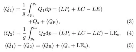
where g is gravitational acceleration,L is the latent heat of condensation,Pris rainfall,E is the evaporation rate of cloud droplets in the air column,C is the generation of liquid water via water vapor condensation in the air column(excluding raindrops),LEsis the surface latent heat flux,ptis the pressure at the top of the troposphere(set to 300 hPa),Qsis the
surface sensible heat flux and〈Qr〉is the vertical integral of radiative heating or cooling.
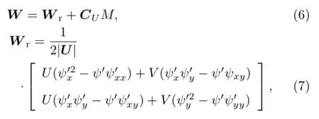
Takaya and Nakamura(2001)derived a wave activity flux for migratory and stationary Rossby waves relative to the background flow and independent of wave phase.This wave activity flux can be used to diagnose the propagation of wave energy.The horizontal component is calculated in pressure coordinates,and has the form

3.General characteristics of summer rainfall over central China
The general features of annual and summer precipitation in central China provide necessary context for studying summer RMDPE episodes. Figure 1 shows maps of the 50-yr climatological annual mean and summer mean rainfall and the fractional contribution(%)of summer precipitation to total precipitation.Annual mean precipitation decreases progressively from south to north over this region.The areas south of the Yangtze River receive greater than 1000 mm of rainfall per year,while much of the areas north of the Yangtze River receive less than 1000 mm.The latitudinal variation of summer precipitation is less clear.The maximum summer precipitation (>650 mm)is located at Enshi,Hubei Province.
Summer rainfall accounts for more than 50%of the total precipitation over much of Henan and more than 40%over most parts of Hubei,but only about 30%over central-southern Hunan.The spatial distribution of the ratio of summer to annual mean precipitation is approximately opposite to the spatial distribution of annual mean precipitation,with a northward increase in the relative contribution of summer rainfall.
Figure 2 shows the spatial distributions of maximum daily rainfall.The maximum daily rainfall during summer was 755.1 mm on 7 August 1975 in Shangcai,Henan.This county is located in the northern part of central China,and the daily mean precipitation over the past 50 years at this location was relatively low.In fact,this record daily rainfall approached the annual mean precipitation at this station(874.4 mm).This rainfall event can be attributed to the direct effects of Typhoon No.7503.
Precipitation in central China varies on multiple timescales.Figure 3 shows interannual variations in the relative anomalies of annual and summer precipitation over central China relative to the 1961-2010 climatological means.No trends are apparent in the relative anomaly of annual mean rainfall;however, these anomalies do vary on interannual and decadal timescales.Years of high and low rainfall tended to alternate.On the decadal scale,less rainfall occurred over central China before the 1990s,followed by a period of relatively plentiful rainfall that lasted until 2004.Rainfall was relatively scarce during 2005-2010.In contrast to annual rainfall,summer rainfall has increased over the past 50 years at a rate of 15.9 mm decade-1(significant at the 0.05 level based on Student’s t-test).Summer rainfall was relatively low during the 1960s and early 1970s,high during the late 1970s and early 1980s,low from the mid 1980s until the early 1990s,and high during the following 20 years.This result is consistent with the conclusions of previous studies of abrupt changes in summer precipitation over central China,particularly with respect to the differences in the variability of annual and seasonal rainfall and the abrupt increase in precipitation that occurred between the end of the 1980s and the early 1990s(Sun et al.,2010).
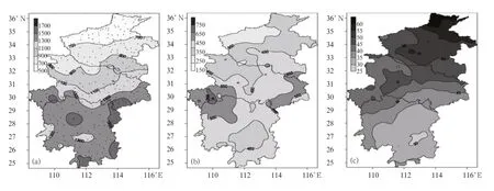
Fig.1.Climatological mean(a)annual and(b)summer precipitation(mm)over central China during 1961-2010 and (c)the fraction in percentage of total precipitation that occurs during summer.Black dots in(a)indicate the locations of the meteorological stations used in this study.
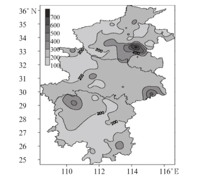
Fig.2.Maximum single-day summer rainfall(mm)during 1961-2010.
The spatial patterns of climatological annual and summer precipitation are vastly different(Fig.1).The interannual and decadal variability of summer rainfall anomalies over central China also differs from the variability of annual rainfall anomalies(Fig.3).In particular,summer rainfall has increased significantly.No similar trends can be identified in annual rainfall.
4.Definition and characteristics of summer RMDPE events in central China
By definition,RMDPE events are small probability episodes for each station where they occur.Urban floods are possible when extreme precipitation events occur at even one station;however,RMDPE events typically occur on regional scales,so they affect multiple stations simultaneously.Ground and river water levels can rise substantially over a very short time, potentially resulting in large-scale natural disasters (Guan et al.,2011).We define RMDPE events as those events with regional mean daily rainfall exceeding a
particular percentile relative to the long-term time series of rainfall amount.

Fig.3.Anomalies in the ratio(%)of(a)annual and(b)summer precipitation(mm)over central China relative to the 1961-2010 climatological means.
4.1 Definition of RMDPE events
In total,the summers(JJA)of 1961-2010 comprise 4600 days.Mean rainfall over central China exceeded 1 mm on 3458 of these 4600 days.We construct a time series of rainfall amount using these 3458 samples.The 99th percentile of regional mean daily rainfall amount based on this time series is 23.585 mm. We use this 99th percentile value as the criterion for selecting the summer RMDPE events in central China. A total of 35 events meet this criterion(Table 1).A subset of these 35 events are described in more detail in Appendix I.
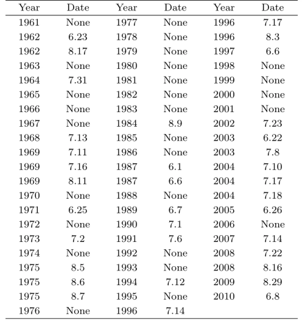
Table 1.Dates(month.day)of RMDPE events over central China during summers of 1961-2010
4.2 Temporal variability
RMDPE events in central China varied on interdecadal timescales during the analysis period.Figure 4a shows the frequency of RMDPE events by year. Three RMDPE events occurred during each year of 1969,1975,1996,and 2004,but no RMDPE events occurred between 1976 and 1983.RMDPE events have occurred relatively frequently since 2002.
Figure 4b shows the occurrence of RMDPE events at 10-day intervals during summer.RMDPE events were most frequent during mid July(9 events),while no episodes took place during mid June.These results indicate that the likelihood of an RMDPE event increase substantially from mid June to mid July.This increase in likelihood is consistent with the seasonal development of the Meiyu rain band.
4.3 Spatial distribution
The mean daily rainfall averaged over the 35 RMDPE events is much larger than the climatological mean daily rainfall during summer.The largest amounts of precipitation associated with RMDPE events occurred,in order,over southwestern Luohe Prefecture in Henan,the Tangbai River catchment area in Henan,and Xiaogan County in northeastern Hubei.The intensity of rainfall during RMDPE events exceeded 60 mm day-1over these three locations(Fig.5a).The spatial pattern of differences between the mean daily rainfall during the 35 RMDPE events and the climatological mean daily rainfall during summer(Fig.5b)is largely consistent with the spatial pattern of the daily mean during the RMDPE events.The mean daily rainfall associated with the 35 RMDPE events is generally greater than the climatological mean daily rainfall during summer,with the exception of a small area in southern Hunan.The spatial pattern of the fractional contribution of RMDPE events to total summer rainfall(Fig.5c)is also similar to the mean daily rainfall during the RMDPE events. RMDPE days are only 1%of the total number of days, but account for more than 10%of the total summer rainfall in central Henan.
Summertime RMDPE events are of regional scale and are typically associated with persistent large-scale precipitation. These events are therefore relatively likely to result in flooding,especially in the mountainous areas of central China.We provide a partial description of the disastrous consequences of these 35 RMDPE events in Appendix I.
5.Circulation anomalies associated with summer RMDPE events

Fig.4.Occurrence frequencies of RMDPE events in central China during 1961-2010 by(a)year and(b)10-day periods during summer(from early June to late August).
The occurrence of regional RMDPE events may be attributed to local circulation anomalies.Analysis of the 35 RMDPE events relative to the strongest single-day summertime precipitation event(Fig.2) shows that the catastrophic rainstorm over Henan during 5-7 August 1975 was directly related to Typhoon No.7503.Rainfall of this intensity and its impacts occurred only once in central China between 1961 and 2010.A number of previous studies have examined the causes and circulation patterns associated with this event(Research Team of the 1975 August Rainstorm,1977a,b;Ding et al.,1978;Beijing Cooperative Research Group for“75.8”Heavy Rain,1979; Tan and Chen,2008).Considering that this typhooninfluenced RMDPE event(counted as three RMDDE events in Table 1)was a special case,we focus our analysis on the other 32 RMDPE events(excluding 5-7 August 1975).The spatiotemporal characteristics of these 32 events are shown in Appendix II for reference.
5.1 Circulation patterns
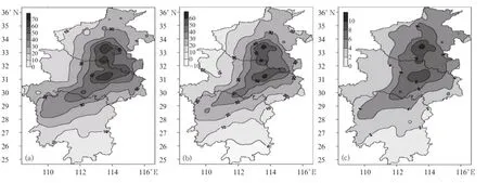
Fig.5.(a)Mean daily rainfall(mm)during the 35 RMDPE events,(b)differences(mm)between mean daily rainfall during RMDPE events and the climatological mean,and(c)fractional contribution(%)of RMDPE events to total summer rainfall during 1961-2010.
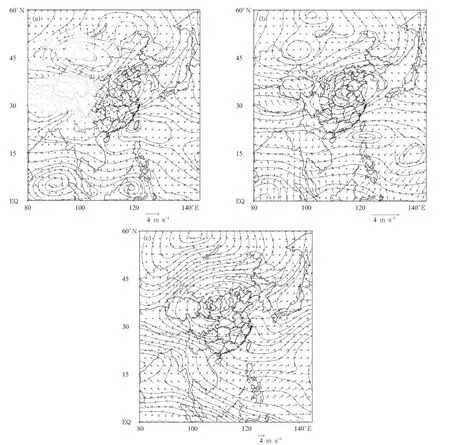
Fig.6.Mean composite anomalies of rotational(stream lines)and divergent(vectors)wind components(m s-1)at (a)850,(b)500,and(c)200 hPa for the 32 RMDPE events relative to the summertime climatological mean circulation during 1961-2010.
RMDPE episodes occur under the control of local circulation anomalies.Figure 6 shows the difference between the mean circulation composited over the 32 RMDPEs and the summer climatology(RMDPE minus climatology).RMDPE events were associated with robust cyclonic circulation anomalies in the middle and lower troposphere over central China(Figs.6a and 6b),centered near 35°N.Southwesterly anomalies to the south favored a deepening of the trough over central China.Anomalous anticyclones occurred over Mongolia and Siberia in higher latitudes,and the South China Sea(SCS)and Northwest Pacific at lower latitudes.The northern anticyclonic anomaly steered cold air southward,while the southwesterly flow associated with the low-latitude anticyclonic steered warm and moist air northward.These two flows acted together to produce strong rainfall over central China. The composite circulation in the upper troposphere (Fig.6c)featured an anomalous anticyclone to the north of Lake Baikal and a robust anomalous cyclone over northwestern China.The South Asian high was expected to be weaker than normal.These anomalies enhanced the eastward zonal flow in the upper troposphere over central China.This zonal flow was located between the outer flows of the cyclonic anomaly to the north and the anomalous anticyclonic flow to the south,and acted to enhance upper tropospheric divergence over central China.The upper tropospheric cyclone over the western North Pacific shifted substantially eastward of Japan.The circulation over central
China was therefore baroclinic,and favored the genesis and maintenance of cloudbursts.
Composite anomalies in the divergent component of the horizontal wind also facilitated the occurrence of RMDPE events. Convergence was anomalously strong in the lower and middle troposphere over central China,while divergence was anomalously strong over the region northwest of central China.Divergence was anomalously strong in the upper troposphere over central China,consistent with both the cyclonic circulation to the northwest and the anticyclonic flow to the south.
Anticyclone-cyclone-anticyclone anomalies were prevalent from the northwest to the southeast at different levels in the troposphere.This sequence of anomalies may be evidence of wave disturbances propagating from the midlatitudes.
5.2 Vertically integrated water vapor fluxes
Abnormal water vapor transport facilitated the genesis of RMDPE episodes.Figure 7 shows water vapor fluxes integrated from the surface to 300 hPa. During RMDPE events,water vapor entered central China through the outer region of the anomalous anticyclones over the Bay of Bengal and SCS in a stepped manner.Differences in mean water vapor flux divergence between RMDPE composite and the 1961-2010 climatology show decreases in water vapor flux divergence over central China and the area to the east of central China.By contrast,water vapor flux divergence was anomalously high over Shaanxi Province and southern China. Anomalously high water vapor flux convergence over central China evidently provided enough water vapor to facilitate the occurrence of RMDPE events.
5.3 Wave activity fluxes

Fig.7.Composite anomalies of the stream function(kg m-1s-1;vectors)and divergence(kg m-2s-1;solid lines) of the vertically integrated water vapor flux during the 32 RMDPE events.Bold arrows indicate vapor fluxes for which both zonal and meridional components are greater than 100 kg m-1s-1.Grey shaded areas indicate values of water vapor flux divergence that are significant at the 99%confidence level using Student’s t-test.
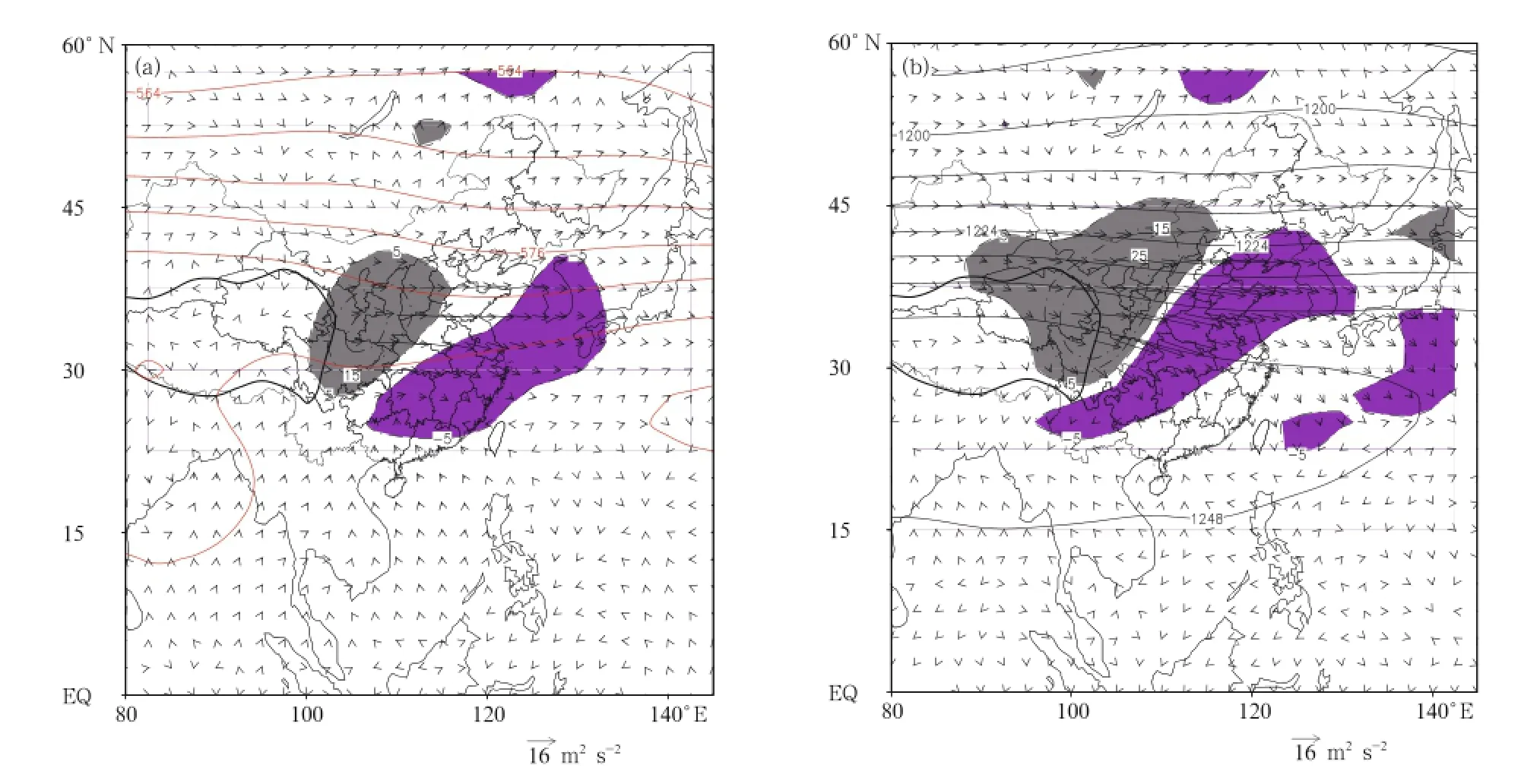
Fig.8.Wave activity flux(m2s-2;arrows)and wave activity flux divergence(10-6m s-2;shading)as derived from composites of anomalous rotational winds,and summertime mean geopotential height(dgpm;solid lines)at(a)500 and (b)200 hPa.Dark shading indicates wave activity flux divergence greater than 5×10⁻⁶m s-2,while light shading indicates wave activity flux divergence less than-5×10⁻⁶m s-2.The thick solid curve denotes the Tibetan Plateau.
Wave activity fluxes depict the direction of wave energy propagation.Figure 8 shows the horizontal component and divergence of TN fluxes(excluding CUM;see Eqs.(6)and(7))in the middle and upper troposphere.Mei and Guan(2008,2009)studied upper tropospheric baroclinic wave activity over the mid-lower Yangtze River valley during the Meiyu period of 1998 and over the Jiang-Huai River valley during the Meiyu period of 2003.They reported that baroclinic waves organize into a wave packet that moves downstream,carrying disturbance energy that can accumulate to support the genesis and development of localized rainstorms.Without consideration of CUM,perturbation energy from the northeastern Tibetan Plateau and Hexi Corridor converged over central China(Fig.8).The accumulation of energy over central China favored the development and maintenance of disturbances in central China,and promoted the occurrence of RMDPE events.Park and Schubert(1997)suggested that the 1994 severe summer drought over eastern Asia might have been associated with interactions between atmospheric disturbances and the topography of the Tibetan Plateau. Figure 8 shows that wave energy fluxes emerged at the northern and northeastern boundaries of the Tibetan Plateau,suggesting that the enhancement and eastward propagation of these disturbances are likely to be linked to the effects of complex terrain.
5.4 Heating field
Figure 9 shows composite anomalies in apparent heat source and apparent water vapor sink for RMDPE events relative to the summer climatological mean.The spatial distributions and orders of magnitude of these two variables are largely consistent. The largest values are located over eastern and central China,where the apparent heat source is approximately 500 W m-2and the apparent water vapor sink is approximately 400 W m-2.As the surface sensible heat and evaporative fluxes are typically very small during rainstorms(Wang et al.,2008),these maxima are primarily due to condensational heating associated with strong convective precipitation(e.g.,Guan et al., 2011;Song et al.,2011).Note that the heat source and water vapor sink are both negative over northwestern China,and the heat source is also negative over the western North Pacific and the SCS(with absolute values of approximately 400 W m-2),suggesting that the heating and cooling contrast from the region northeast of Tibetan Plateau southeastward to the Taiwan region may play a certain role in the occurrences of RMDPE over central China.
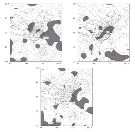
Fig.9.Composite anomalies of vertically-integrated(a)apparent heat sources〈Q1〉,(b)apparent water vapor sinks〈Q2〉,and(c)differences between the two(〈Q1〉-〈Q2〉)during the 32 RMDPE events relative to the summertime climatological mean during 1961-2010.All data are in unit of W m-2.Shaded areas indicate values that are significant at the 99%confidence level based on Student’s t-test.
The difference〈Q1〉-〈Q2〉indicates the portion of diabatic heating not due to condensation of water vapor.Figure 9c shows composite anomalies of this quantity for the 32 RMDPE events relative to the summertime climatological mean.Small values indicate that latent heating due to condensation plays a dominant role in the local heat budget.Positive values indicate radiative heating and/or heating by the surface sensible or latent heat flux,while negative values indicate radiative cooling and/or cooling by the surface sensible or latent heat flux(Han et al.,2012). Anomalies of〈Q1〉-〈Q2〉associated with RMDPE are positive in the western part of central China,which indicates that rainfall associated with RMDPE events was stronger over the eastern part of central China. Anomalies of〈Q1〉-〈Q2〉are negative over the region south of central China and the coastal regions. Negative values of〈Q1〉-〈Q2〉suppressed air-column heating and associated upward motion;however,neg-
ative values of〈Q1〉-〈Q2〉over the Bay of Bengal, SCS,and western North Pacific promoted lower tropospheric divergence and enhanced water vapor convergence over central China.Han et al.(2012)examined summertime RMDPE over the mid-lower reaches of the Yangtze River valley.They found that anticyclonic anomalies tend to develop to the northwest of the regions of diabatic cooling.The genesis of these anticyclonic anomalies excites wave trains traveling toward the north and east,and provides large-scale disturbances that could promote the development of RMDPE events.No distinct wave trains propagating northeastward from the SCS are apparent in Fig. 6.Nevertheless,the horizontal gradient in diabatic heating is extremely beneficial to the production and maintenance of ascending motion over central China, furnishing a necessary condition for RMDPE episodes.
6.Concluding remarks
We have performed a composite analysis of regional mean daily precipitation extreme(RMDPE) events during 1961-2010.The conclusions are as follows.
The pattern of annual mean rainfall averaged over central China exhibits a pronounced dependence on latitude(decreasing from south to north)and significant interannual variations,but with no apparent long-term trend.By contrast,the 1961-2010 summer mean precipitation has increased at a rate of 15.9 mm per decade and has a very different spatial distribution,with a maximum of more than 650 mm centered at Enshi,Hubei Province.The fractional contribution of summer rainfall to total annual precipitation increases from south to north.
The 99th percentile of regional mean daily precipitation between 1961 and 2010 was 23.585 mm day-1. The occurrence frequency of RMDPE events(defined as daily precipitation exceeding the 99th percentile) varied substantially on interannual and interdecadal timescales,with a marked increase after the mid 1980s. RMDPE events occurred more frequently between late June and mid July.
The genesis and maintenance of RMDPE events were associated with robustcyclonic circulation anomalies in the lower and middle troposphere over central China.The composite upper-level flow over central China was more zonal than normal during RMDPE events,which promoted upper-level divergence. Anomalous convergence in the lower and middle troposphere over central China reflected enhanced flow from the western North Pacific. The baroclinic structure of the anomalous tropospheric circulation promoted the formation and maintenance of the RMDPE events.Water vapor converged over central China in a stepped fashion via the outer regions of the anomalous low-level anticyclones over the Bay of Bengal and the SCS.RMDPE events were associated with anomalous water vapor convergence over central China and the areas to the east,and anomalous water vapor divergence over Shaanxi and southern China.Strong water vapor convergence over central China also favored the development and maintenance of RMDPE events.
The circulation anomalies associated with RMDPE events were connected to wave disturbances and atmospheric heating anomalies.RMDPE events over central China were associated with the eastward propagation of Rossby wave disturbance energy from the northeastern Tibetan Plateau.These wave disturbances appeared to be caused by the complex terrain in this region.Anomalies in the apparent heat source and water vapor sink associated with RMDPE events were positive over central China and negative(or small)over the surrounding areas.Diabatic heating anomalies due to processes other than condensation were positive over the western part of central China and negative over surrounding areas.The resulting gradient in diabatic heating anomalies promoted ascending motion over central China.
Rossby wave energy in this region appeared to originate mainly over the northeastern Tibetan Plateau and propagated eastward(Fig. 8). This feature suggests that topographic effects may play an important role in the genesis and maintenance of RMDPE events over central China,particularly with respect to the high topography over Lanzhou and the associated baroclinic circulation in the middle and up-
per troposphere.The magnitude of this role remains to be revealed in future.
Appendix I∗
Central China suffered a number of severe disasters associated with RMDPE events between 1961 and 2010(Wen and Pang,2005;Wen and Zeng,2006; Wen and Jiang,2007;China Meteorological Administration,2008,2009,2010).This appendix describes the serious consequences of selected RMDPE events. For detailed description of those events and associated damage statistics,refer to the Chinese version of this paper(doi:10.11676/qxxb2014.037).
Appendix II
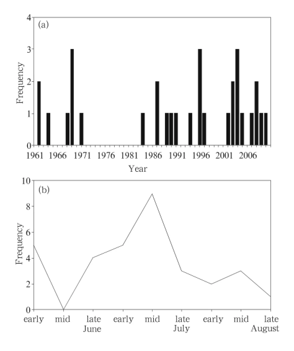
Fig.A.Occurrence frequencies of summertime RMDPE events in central China during 1961-2010 excluding the three days of Typhoon No.7503 by(a)year and(b)10-day intervals during JJA(from early June to late August).

Fig.B.Daily rainfall(mm)averaged over 32 summer RMDPE events in central China(excluding Typhoon No. 7503)during 1961-2010.
Figure A shows the spatiotemporal patterns of rainfall for 32 RMDPE events,excluding the three days of Typhoon No.7503.Comparison with Fig.4 shows that the three episodes in August 1975 are due to the passage of the typhoon.This extends the break without summertime RMDPE events to 1975-1983(a total of 9 yr),and reduces the frequency of RMDPE events in early August to two.
The spatial distribution of mean daily rainfall averaged over these 32 RMDPE events(Fig.B)shows no significant change relative to that averaged over all 35 RMDPE events(Fig.5a).Excluding the typhoon reduces the area of the maximum,with drops in mean daily rainfall over Henan and the emergence of a new local maximum(74.3 mm)in Anlu,Xiaogan,Hubei.
Acknowledgments.We are grateful to Wuhan Regional Climate Center for providing station rainfall data and records of central China meteorological disasters. The NOAA-CIRES Climate Diagnostics Center provided the reanalysis data(http://www.cdc. noaa.gov).All graphs were made using the Grid Analysis and Display System(GrADS).
Bao Ming and Huang Ronghui,2006:Characteristics of the interdecadal variations of heavy rain over China in the last 40 years.Chinese J.Atmos.Sci.,30, 1057-1067.(in Chinese)
∗Data given for some RMDPE episodes during 1961-2000 are taken from the compiled Henan,Hubei,and Hunan Volumes of the Yearly Book of Meteorological Disasters in China,the 2001-2007 data are from the Regional Meteorological Center at Wuhan, and the 2008-2010 statistics is from the Chinese Yearly Book for Meteorological Disasters.
Beijing Cooperative Research Group for“75.8”Heavy Rain,1979:A diagnostic analysis about the“75.8”heavy rain in Henan.Acta Meteor.Sinica,37,45-55.(in Chinese)
Bei Naifang and Zhao Sixiong,2002:Mesoscale analysis of severe local heavy rainfall during the second stage of the 1998 Meiyu season.Chinese J.Atmos.Sci., 26,526-540.(in Chinese)
Buffoni,L.,M.Maugeri,and T.Nanni,1999:Precipitation in Italy from 1833 to 1996.Theor.Appl. Climatol.,63,33-40.
Chen Bo,Shi Ruiqin,and Chen Zhenghong,2010:The variation tendency of heavy precipitation events in different grades during recent 45 years over central China.J.Appl.Meteor.Sci.,21,47-54.(in Chinese)
China Meteorological Administration,2008:Yearbook of Meteorological Disasters in China(2008). China Meteorological Press,Beijing,233 pp.(in Chinese)
—-,2009:Yearbook of Meteorological Disasters in China (2009).China Meteorological Press,Beijing,203 pp.(in Chinese)
—-,2010:Yearbook of Meteorological Disasters in China (2010).China Meteorological Press,Beijing,221 pp.(in Chinese)
Ding Yihui,Cai Zeyi,and Li Jishun,1978:The exceptional torrential rain event in early August of 1975 over Henan.Chinese J.Atmos.Sci.,2,276-298. (in Chinese)
Easterling,D.R.,J.L.Evans,P.Y.Groisman,et al., 2000:Observed variability and trends in extreme climate events:A brief review.Bull.Amer.Meteor.Soc.,81,417-425.
Groisman,P.Y.,T.R.Karl,D.R.Easterling,et al., 1999:Changes in the probability of heavy precipitation:Important indicators of climatic change. Climatic Change,42,243-283.
Guan Zhaoyong,Han Jie,and Li Minggang,2011:Circulation patterns of regional mean daily precipitation extremes over the middle and lower reaches of the Yangtze River during the boreal summer.Climate Research,50,171-185.
—-and Ren Guoyu,2012:On Variations of Weather and Climate Extremes in China.China Meteorological Press,Beijing,347 pp.(in Chinese)
Han Jie,Guan Zhaoyong,and Li Minggang,2012:Comparisons of circulation anomalies between the daily precipitation extreme and non-extreme events in the middle and lower reaches of Yangtze River in boreal summer.J.Trop.Meteor.,28,367-378.(in Chinese)
Hawkins,D.M.,1977:Testing a sequence of observations for a shift in location.J.Amer.Statist.Associat., 72,180-186.
He Shuqiao,Zheng Youfei,and Yin Jifu,2013:An analysis on precipitation characteristics over middle and lower reaches of Yangtze River in the last 50 years. J.Ecolog.Environ.,22,1187-1192.(in Chinese)
Huang Ronghui,Xu Yuhong,Wang Pengfei,et al.,1998: The features of the catastrophic flood over the Changjiang River basin during the summer of 1998 and cause exploration.Climatic Environ.Res.,3, 300-313.(in Chinese)
IPCC,2012:Managing the Risks of Extreme Events and Disasters to Advance Climate Change Adaptation: Special Report of the Intergovernmental Panel on Climate Change.Cambridge University Press,582 pp.
Jiao Jianli and Kang Wenying,2007:Analysis on regional characters of the annual rainfall in Henan Province.Journal of North China Institute of Water Conservancy and Hydroelectric Power,28,7-10. (in Chinese)
Karl,T.R.,and R.W.Knight,1998:Secular trends of precipitation amount,frequency,and intensity in the United States.Bull.Amer.Meteor.Soc.,79, 231-241.
Kistler,R.,W.Collins,S.Saha,et al.,2001:The NCEPNCAR 50-year reanalysis:Monthly means CD-ROM and documentation.Bull.Amer.Meteor.Soc.,82, 247-267.
Kunkel,K.E.,K.Andsager,and D.R.Easterling,1999: Long-term trends in extreme precipitation events over the conterminous United States and Canada. J.Climate,12,2515-2527.
Li Qingxiang,Jiang Zhihong,Huang Qun,et al.,2008: The experimental detecting and adjusting of the precipitation data homogeneity in the Yangtze delta. J.Appl.Meteor.Sci.,19,219-226.(in Chinese)
Manton,M.J.,P.M.Della-Marta,M.R.Haylock,et al.,2001:Trends in extreme daily rainfall and temperature in Southeast Asia and the South Pacific: 1961-1998.Int.J.Climatol.,21,269-284.
Mei Shilong and Guan Zhaoyong,2008:Activities of baroclinic wave packets in the upper troposphere related to Meiyu of 2003 in the Yangtze River-Huaihe River valley.Chinese J.Atmos.Sci.,32,1333-1340.(in Chinese)
—-and—-,2009:Propagation of baroclinic wave packets in upper troposphere during the Meiyu period of 1998 over middle and lower reaches of Yangtze River valley.J.Trop.Meteor.,25,300-306.(in Chinese)
National Climate Center,1998:The Severe Floods and Climatic Anomaly in China in 1998.China Meteorological Press,Beijing,139 pp.(in Chinese)
Park,C.K.,and S.D.Schubert,1997:On the nature of the 1994 East Asian summer drought.J.Climate, 10,1056-1070.
Pettitt,A.N.,1979:A non-parametric approach to the change-point problem.Applied Statistics,28,126-135.
Qin Jun and Wang Haijun,1997:The study of air temperature and rainfall trend of Hubei Province since 1961.Journal of Huazhong(Central China)Agricultural University,16,405-410.(in Chinese)
Ren Guoyu,Wu Hong,and Chen Zhenghong,2000:Spatial patterns of change trend in rainfall of China.J. Appl.Meteor.Sci.,11,322-330.(in Chinese)
Ren Yongjian,Gao Yuan,Xiao Ying,et al.,2013:Analysis of the precipitation change character over Central China from 1961 to 2010.Resources and Environment in the Yangtze Basin,22(S1),90-95. (in Chinese)
Research Team of the 1975 August Rainstorm,1977a: Primary analysis of the causes of cloudburst in August of 1975(1).Meteor.Mon.,7,3-5.(in Chinese)
—-,1977b:Primary analysis of the causes of cloudburst in August of 1975(2).Meteor.Mon.,7,6-8.(in Chinese)
Solow,A.R.,1987:Testing for climate change:An application of the two-phase regression model.J.Climate Appl.Meteor.,26,1401-1405.
Song Dawei,Guan Zhaoyong,and Tang Weiya,2011: Variations of OLR in maritime continent regions in association with droughts and floods in the upper and middle reaches of Yangtze River of China in boreal summer.J.Trop.Meteor.,27,560-568.(in Chinese)
Stone,D.A.,A.J.Weaver,and F.W.Zwiers,1999: Trends in Canadian precipitation intensity.Atmos. Ocean,38,321-347.
Sun Jie,Xu Yang,Chen Zhenghong,et al.,2010:Characteristics of precipitation in central region of China over 45 years.Resources and Environment in the Yangtze Basin,19,45-51.(in Chinese)
Sun Shuqing and Ma Shujie,2001:A study on the relationship between the anomaly of subtropical high over the western Pacific and the heavy flooding in Yangtze River valley in 1998.Acta Meteor.Sinica, 59,719-729.(in Chinese)
Takaya,K.,and H.Nakamura,2001:A formulation of a phase-independent wave-activity flux for stationary and migratory quasigeostrophic eddies on a zonally varying basic flow.J.Atmos.Sci.,58,608-627.
Tan Yan and Chen Dehui,2008:Mesoscale ensemble forecasts on“75.8”heavy rain in Henan.Meteor. Mon.,34,10-21.(in Chinese)
Wang Jianjie and Li Zechun,2002:Numerical simulation and diagnostic analysis on mesoscale convective systems of a torrential rain case in Meiyu period of 1998.Acta Meteor.Sinica,60,146-155.(in Chinese)
Wang Lijuan,Guan Zhaoyong,and He Jinhai,2008:Circulation background of the extremely heavy rain causing severe floods in Huaihe River valley in 2003 and its relationships to the apparent heating.Scientia Meteor.Sinica,28,1-7.(in Chinese)
Wang,Y.Q.,and L.Zhou,2005:Observed trends in extreme precipitation events in China during 1961-2001 and the associated changes in large-scale circulation.Geophys.Res.Lett.,32,L09707,doi: 10.1029/2005GL022574
Wang Zhifu and Qian Yongfu,2009:Frequency and intensity of extreme precipitation events in China. Adv.Water Sci.,20,1-9.(in Chinese)
Wang Zhiwei,Zhai Panmao,Tang Hongyu,et al.,2005: Variation of characteristics of waterlogging by rain over southern China in the last half century.J.Natural Disasters,14,56-60.(in Chinese)
Wen Kegang and Pang Tianhe,2005:Yearly Book of Meteorological Disasters of China(Henan Volume). China Meteorological Press,Beijing,398 pp. (in Chinese)
—-and Zeng Qinghua,2006:Yearly book of Meteorological Disasters of China(Hunan Volume).China Meteorological Press,Beijing,509 pp.(in Chinese)
—-and Jiang Hairu,2007:Yearly Book of Meteorological Disasters of China(Hubei Volume).China Meteorological Press,Beijing,462 pp.(in Chinese)
Wijngaard,J.B.,A.M.G.Klein Tank,and G.P.K¨onnen, 2003:Homogeneity of 20th century European daily temperature and precipitation series.Int.J.Climatol.,23,679-692.
Xiao Yan,Li Zuxian,Zhang Xinping,et al.,2010:Research on extreme precipitation event characteristics
of Xiangjiang River basin in recent 48 years.Resources and Environment in the Yangtze Basin,19, 1356-1362.(in Chinese)
Xu Shuangzhu,Zou Liwei,Liu Huosheng,et al.,2008: Mesoscale system and numerical simulation analysis of heavy rain in Hubei Province during Meiyu. Plateau Meteor.,27,567-575.(in Chinese)
Yamamoto,R.,and Y.Sakurai,1999:Long-term intensification of extremely heavy rainfall intensity in recent 100 years.World Resource Review,11,271-282.
Zhai,P.,A.Sun,F.Ren,et al.,1999a:Changes of climate extremes in China.Climatic Change,42,203-218.
—-,Ren Fumin,and Zhang Qiang,1999b:Detection of trends in China’s precipitation extremes.Acta Meteor.Sinica,57,208-216.(in Chinese)
—-,and X.H.Pan,2003:Change in extreme temperature and precipitation over northern China during the second half of the 20th century.Acta Geographica Sinica,58,1-10.
Zhang Jianming,Li Zuxian,and Zhang Xinping,2008: Precipitation change in Hunan Province.Adv.Climate Change Res.,4,101-105.(in Chinese)
Zhang Xiaoling,Tao Shiyan,Zhang Shunli,et al.,2004: A case study of persistent heavy rainfall over Hunan Province in July 1996.J.Appl.Meteor.Sci.,15, 21-31.(in Chinese)
Zhang Yan,Ding Yihui,and Ma Qiang,2001:Analysis of the atmospheric circulation in relation to persistent rain storm on the Meiyu front.Climatic Environ. Res.,6,161-167.(in Chinese)
Zou Yongchang,Yang Xiuqun,Sun Xuguang,et al.,2009: Seasonal difference of the spatio-temporal variation of the number of the extreme precipitation processes in China.J.Nanjing Univ.(Nat.Sci.Ed.),45, 98-109.(in Chinese)
:Ke Dan and Guan Zhaoyong,2014:Variations in regional mean daily precipitation extremes and related circulation anomalies over central china during boreal summer.J.Meteor.Res.,28(4), 524-539,
10.1007/s13351-014-3246-9.
(Received March 2,2014;in final form June 18,2014)
杂志排行
Journal of Meteorological Research的其它文章
- Chinese Contribution to CMIP5:An Overview of Five Chinese Models’Performances
- Track of Super Typhoon Haiyan Predicted by a Typhoon Model for the South China Sea
- The Persistent Heavy Rainfall over Southern China in June 2010: Evolution of Synoptic Systems and the Effects of the Tibetan Plateau Heating
- Overview of the Major 2012-2013 Northern Hemisphere Stratospheric Sudden Warming:Evolution and Its Association with Surface Weather
- Characteristics of Meteorological Factors over Different Landscape Types During Dust Storm Events in Cele,Xinjiang,China
- Diagnostic Study of Global Energy Cycle of the GRAPES Global Model in the Mixed Space-Time Domain
