Simulation of urban affordable housing land-use evolution based on CA-MAS model
2014-09-06ZhangJiankunWangYuanyuanWangXiaorongLiJunjie
Zhang Jiankun Wang Yuanyuan Wang Xiaorong Li Junjie
(School of Civil Engineering, Southeast University, Nanjing 210096, China)
Simulation of urban affordable housing land-use evolution based on CA-MAS model
Zhang Jiankun Wang Yuanyuan Wang Xiaorong Li Junjie
(School of Civil Engineering, Southeast University, Nanjing 210096, China)
In order to simulate the evolution of affordable housing land use, a dynamic model that combines cellular automata (CA) and a multi-agent system (MAS) is established. This paper aims to utilize the approach of decision factors on site selection of affordable housing through a literature review to construct a hierarchy model of those factors, identifying the weight of each factor by an analytic hierarchy process (AHP). Based on those weight factors, the CA-MAS model is designed. Nanjing city is taken as an example to verify the feasibility of the model. The results show that the CA-MAS model is pragmatic and effective in simulating evolution of affordable housing land use, which also promotes the fundamental understanding and perception of the development of affordable housing and urbanization.
affordable housing; land use; CA-MAS model; simulation
The housing issue is a grave concern because it is directly related to the livelihoods of the citizens[1]. In order to meet basic needs of low-income families and adapt to the ugent social demand, many districts in China have been built with affordable housing on a large scale. The reasonable evolution of urban land is an adaptive adjustment of urban system functions, which promotes the healthy development of the city and enhances its competitiveness. Therefore, the establishment of the dynamic model simulating affordable housing land use is of theoretical and practical significance to understand urbanization, especially the basic rules of land-use changes.
The evolution of affordable housing land is influenced not only by natural and social factors, but also by the underlying driving stimulus of the government and low-income residents’ demand. This paper analyzes the social and natural factors that influence the CA model, followed by a dynamic model with the characteristics of the decision-maker and low-income residents’ demand developed in the MAS model.The CA-MAS model plays a critical role in understanding the development of affordable housing and urbanization.
As representatives of simulating land-use evolution, the CA and MAS models have been widely used in the research domestically and abroad[2].Since the CA model is of discrete dynamical systems[3],which are particularly suitable for the research of the geographic system with complex spatial and temporal characteristics.
However, as the CA model is incapable of simulating the effect of different participators and decision makers, the MAS has been introduced. Liu et al.[4-6]treated agents that influenced urban expansion as the research objects, so as to simulate the process of land-use evolution.
1 Construction Methods of CA-MAS Model
1.1 Construction methods
This paper integrates the CA and MAS models to simulate the evolution of affordable housing land. As shown in Fig.1, the CA-MAS model contains an environment-related factors layer, several mobile MAS layers and an immovable CA layer.
The environment-related factors layer refers to the natural environment, which dominates macro control; the MAS layers include the government and residents; the CA layer restrains the model from the angle of individual cells and their neighborhoods, thus to gain a comprehensive effect.
Besides, the environment-related factors layer is defined as the constraints of the entire CA-MAS model. The CA layer defines the social factors that influence land conversion, and the MAS layers define the government and residents’ driving effect. Along with some random interference factors, a total conversion ratePijcan be obtained ultimately.This rate determines the probability that a grid transforms from other land types to the affordable housing land.Pijconsists of five parts:pca,president,pplan,pconstraint,prandom, as shown in Fig.1. Compared with a preset thresholdPthreshold, ifPij>Pthreshold, the land cellular can be converted into affordable housing land; otherwise, the land cellular will maintain its original state.
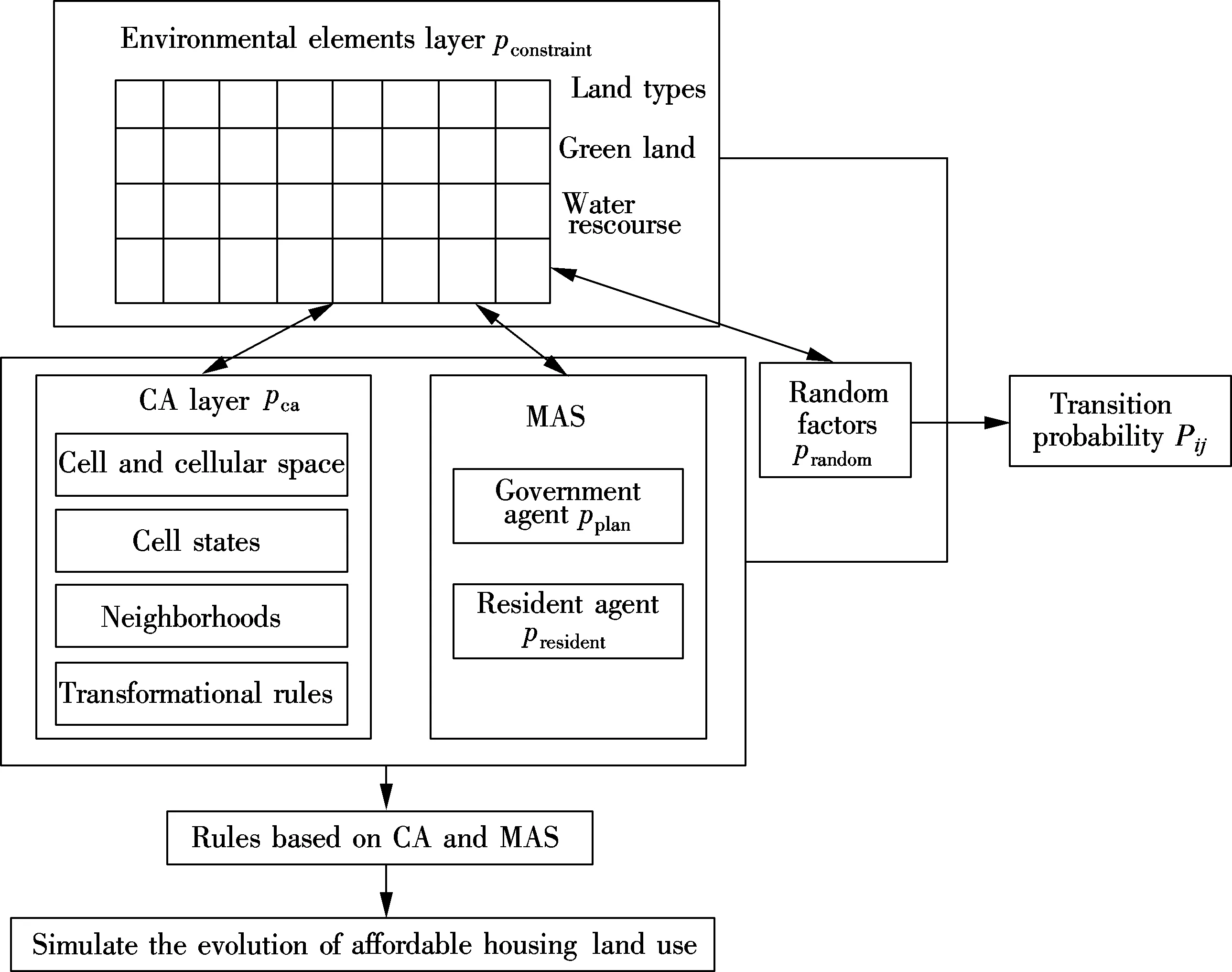
Fig.1 Construction methods of CA-MAS model
1.2 Analysis of affordable housing land driving factors
The driving factors of affordable housing land’s evolution are broadly in line with common residential land. The difference is the particularity of the guaranteed people and the land acquisition. In current studies, the factors affecting the evolution of affordable housing land mainly include: land types, land prices, transportation, infrastructure, environment, education, as shown in Tab.1.
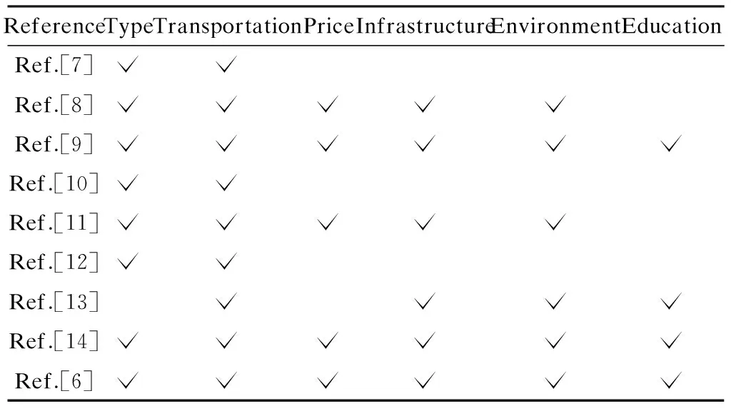
Tab.1 Factors of affordable housing land evolution
1.3 CA layer based on binary logistic regression
The CA consists of five fundamental elements: cell, cellular space, neighbors, transformational rules, and time, as shown in Fig.2. The core of the CA is that the transformational rules determine the state of the cell; i.e., the state of cell in timet+1 is determined by the state of cell in timetand its neighborhoods’ state[15].
1) Cell and cellular space
Cellular space, as the discrete grid of the research area and a single cell, which represents a plot of the research area, is an individual unit of the discrete grid. This paper divides the research area into several squares of side length 30 m.In other words, it means that each cell represents a piece of 30×30=900 m2land within the research area.
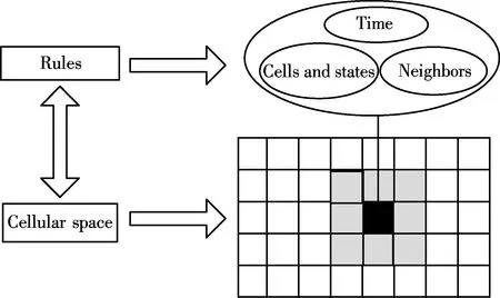
Fig.2 Constitution of CA
2) Cell states
All the cells of the cellular space have merely two states, namely “can be converted into affordable housing land” and “ cannot be converted into affordable housing land” two states. Thus, the state set is defined asS={affordable housing land; other types}, expressed asS={1, 0}.
3) Neighbourhoods
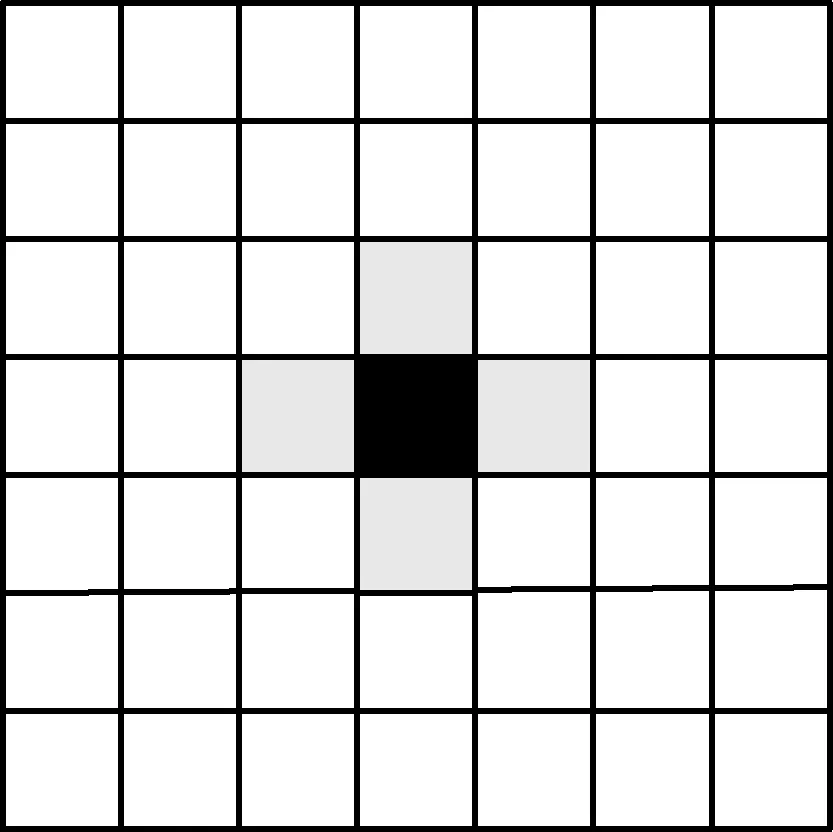
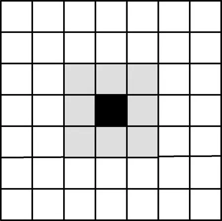
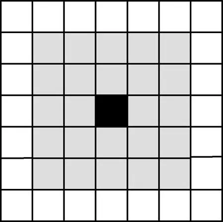
In the CA model, the next moment state of a cell is determined by the state of itself and its neighboring cell state. So the neighbors of the cells must be defined before determining the transformation rules. In fact, the cellular space is the network ofm×n, as shown in Fig.3.
This model uses the extended Moore type, and the neighborhood radiusr=2. That is to say, a cell’s neighboring space is a 5×5 grid which centers on itself. The number of neighboring cells is 5×5-1=24.
(a)
(b)
(c)
4) Transformational rule
The core part of the CA is to define the transformational rules, which control the whole simulation process in the CA model. In this model, all the cells of the cellular space have only two states, namely “can be converted into affordable housing land” and “cannot be converted into affordable housing land”. Therefore, the transformational rule is defined as a binary logistic regression method, which will be used to analyze the social factors that influence affordable housing land evolution (see Tab.2), and the coefficients of variables can be obtained.
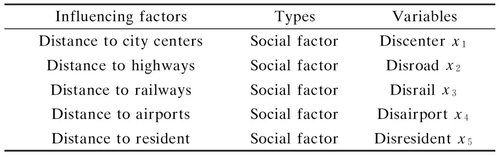
Tab.2 Social influencing factors and their corresponding variables
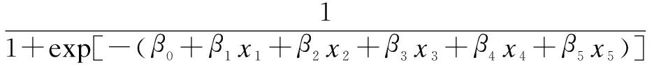
Through the regression of empirical data in order to obtain the weights of factors and establish reliable transformational rules, the conversion probabilitypcaof each grid in the CA model can be obtained[15].
1.4 MAS layer
1) The government agent
The implementation of a government agent’s willingness is achieved through urban planning. In the course of affordable housing land conversion, the function of government planning is stronger than that of residents’ demand. It is assumed that the planning ofN(generally for 3 to 5) years later is developed according to the present data, and then the changes of each cell are influenced by planning are as follows:

2) The resident agent
The resident agents are individuals who have the ability to think and behave independently while seeking better residential conditions. Transportation accessibility, public facilities and good environment quality are the conditions aimed for the selection of an urban residential location.
Transportation accessibility reflects the extent of traffic convenience, which can be evaluated by the distance to subways, bus stops, etc. In the model, the index of the distance decay function is adopted to express their spatial appeal to the location[11]:
Etraffic=a1A1e-B1Dsubway+a2A2e-B2·Dbus
whereEtrafficis the index of transportation accessibility;a1anda2are the weights of the corresponding distance;A1andA2are the strength coefficients of the corresponding distance;B1andB2are the attenuation coefficients of the corresponding distance;DsubwayandDbusare the distances to the subway and bus stops, respectively.
The public facilities’ evaluation factors include distance to hospitals, schools, libraries, recreational facilities, parks, commercial centers (i.e. infrastructure and education resources in Tab.2), and the spatial attraction of all above is expressed by the index distance decay function.
Environmental quality is evaluated by the per capita green area and the distance from water. The per capita green area is expressed by the ratio of the number of green spaces grid within a 5×5 neighboring window to the number of the residential land’s grid:
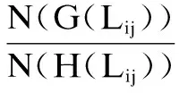
whereEgreenis the evaluation of green land;Lijis a grid of the two-dimensional space;N(G(Lij))is the number of the green land’s grid centered withLij;N(H(Lij)) is the number of the residential land’s grid centered withLij. The influence of water on the environmental quality can also be expressed by the distance decay function as below:
Eenvironment=C1Egreen+C2A3e-B3Dwater
whereEenvironmentis the index of the environmental quality;C1andC2are the weights of green land and water;A3is the strength coefficient of the water;B3is the attenuation coefficient of the water;Dwateris the distance to water.
Based on the assumption that residents pursue maximal utility, this paper studies the resident agent behavior on the choice of residential location with the random utility model and the discrete choice model.
First, according to the random utility model, the utility of the optional locationIto the resident agentnis expressed as
Uin=∂Etraffic+βEconvenience+γEenvironment+εin
where ∂+β+γ=1, and ∂,β,γrepresent, respectively, the resident agentnpreference coefficient for each influencing factor;Etraffic,EconvenienceandEenvironmentrepresent the transportation accessibility, convenience of facilities and environmental quality, respectively. Then the values of ∂,β,γare obtained by the Delphi method and AHP.
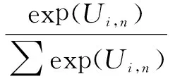
Finally, based on the discrete choice model, the probability of the resident agentnrandomly choosing his housing location atiis equal to the probability that the utility (attraction) ofifor the resident agentnis not less than the utility of any other alternativei; namely,
i=1,2,…,I;i≠i′;n=1,2,…,N
The summation of resident selection probability for some certain location is
President=∑Pi,n
1.5 Random factors
The conversion of land is also affected by the random factors and accidental events. To make the calculation result conform to reality and reflect the uncertainty existing in the city system, the influence of the random factor is added to the model. The item can be expressed as
prandom=1+(-lgγ)∂
In the formula,γis a random number in (0,1); ∂ is a parameter that controls the influence of the random variable, and its value ranging from 1 to 10 is the number of the integer. The greater the value of ∂, the greater the influence of the random variable in the model, the smaller the vice. Conversely, it becomes less important.
1.6 Probability expression
Synthesizing the CA model and the MAS model, the conversion probability of cell(i,j) at the time oftis expressed as
Pij=(apresident+bpplan)pcaprandom
whereaandbare the weights ofpresidentandpplan, respectively, and they are obtained by AHP.
2 Empirical Analysis
2.1 General situation of the study area
The urban district of Nanjing is divided into eight areas, which are the Qixia district, Xuanwu district, Xiaguan district, Gulou district, Baixia district, Qinhuai district, Jianye district and Yuhuatai district, respectively.
In 1990, Nanjing started to construct anti-poverty housing as planned. Until 1995, 1×10⁶m2of anti-poverty housing has been built. From 1995 to 1998, the comfortable housing was brought under construction with the purpose to aid the settling down of families in poverty, relocate households and be part of the teaching faculty. Economical affordable housing was built from 1998 thereafter. The centralization security housing has been massively increased since 2011. Until now, the total construction area of security housing was approximately 28.64×10⁶m2covering the whole of Nanjing.
2.2 Regression results in cellular automata
In the CA model, after the logistic regression analysis on the factors in Tab.3 by the SPSS, it can be seen that the confidence level of each regression coefficient is greater than 95% (i.e., α≤0.05), and all of them, except for Discenter can be incorporated into the regression equation. The historical data of affordable housing land in 2008 and 2012 have been selected.
According to the regression results in Tab.3, it can be seen that the regression coefficients of Disroad and Disairport are positive, indicating that the land is far away from the road and the airport. It can be more easily converted into affordable housing, which is in line with reality. In general, the location of affordable housing is remote. Although there are some positive elements being close to the airport, noise pollution is still a cause of possible disturbance. Therefore, to a certain extent, the expansion of affordable housing land has a positive correlation with the distance from the airport. The regression coefficients of Disrail is negative, indicating that the land closer to railways is converted into affordable housing land with more difficulty and that they are quite consistent with the fact.

Tab.3 Binary logistic regression of influencing factors of CA
2.3 MAS
1) Resident agent
Based on experts’ evaluations, the influencing factors when choosing residential location are determined by the Delphi method, then the obtaining factors’ weights by AHP. The results are shown in Tab.4.
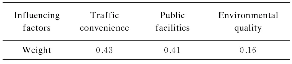
Tab.4 Resident agent’s preference weights for location
2) Government agent
The function of the government agent mainly concerns decision-making; thus, the government in housing location planning decides directly affordable housing land supply and location. So the implementation of the model is mainly as follows: comparing current land-use data and planning data in 2012, if a cell’s state changes,pplanis 1; otherwise,pplanis 0.
2.4 Analysis of simulation results
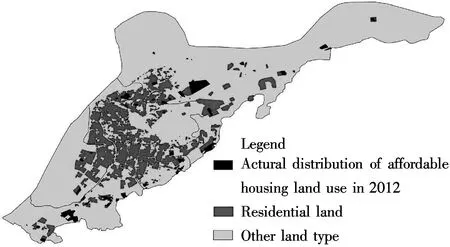
The simulation results show that affordable housing land use in Nanjing is mainly distributed in the Qixia, Xiaguan and Yuhua districts, which is basically in line with the actual situation (see Fig.4). In addition, two basic features can be found in the spatial layout: remote location and relatively concentrated distribution. The location remoteness contributes to the lack of infrastructure in the surroundings and expensive transportation costs, while concentrated distribution may lead to residential space differentiation, which risks the building of large scale centralized affordable housing settlements. These all indicate that it is necessary to fully consider the construction and feasibility of surrounding facilities when planning affordable housing project addresses, thus ensuring that low-income groups live and work in harmonious environments.

(a)
(b)
3 Conclusion
Based on the combination of CA and MAS, a dynamic model of urban land utilization is constructed. By reviewing former research, factors influencing the conversion of affordable housing land utilization are obtained. In the MAS layer, the government and the residents are chosen as two of the most crucial decision-makers influencing the conversion of affordable housing land utilization. Finally, the integration of the CA and MAS models is established, not only taking advantage of the characteristics of holistic transformation generated by self-organized developed regulation law, but also critical decisions are made based on the choices of the resident agent and macro control of the government agent. However, final choices will be made according to the synthesized consideration of the probability of two models. Empirical studies suggest that this dynamic model accurately simulates the evolution status of affordable housing land utilization, providing a decision-making basis for the location of affordable housing and a scientific development of cities.
[1]Cheng M, Zhou H, Zhang Y. Housing planning compilation under the new situation:a case study of Nanjing Pukou District example [J].Planners, 2009, 25(12):84-89. (in Chinese)
[2]Guo H, Li B, Hou Y, et al. Cellular automata model and multi-agent model for the simulation of land use change: a review [J].ProgressinGeography, 2011, 30(11):1336-1344. (in Chinese)
[3]Li X, Yeh A G O. Data mining and geographical cellular automata [J].ScienceinChinaSeriesD:EarthSciences, 2004, 34(9): 865-872. (in Chinese)
[4]Liu X, Li X, Ye J. Multi-agent systems for simulating spatial decision behaviors and land use dynamics [J].ScienceinChinaSeriesD:EarthSciences,2006, 36(11):1027-1036. (in Chinese)
[5]Zhang H, Zeng Y, Jin X. Urban land expansion model based on multi-agent system and application [J].ActaGeographicaSinica, 2008, 63(8):869-881. (in Chinese)
[6]Quan Q, Tian G, Sha M. Dynamic simulation of Shanghai urban expansion based on multi-agent system and cellular automata models [J].ActaEcologicaSinica, 2011, 31(10):2875-2887. (in Chinese)
[7]Li X, Yang Q, Liu X. The evolution of knowledge mining and simulation of urban planning based on CA [J].ScienceinChinaSeriesD:EarthSciences, 2007, 37(9):1242-1251. (in Chinese)
[8]Yang Q, Li X. Agent-based micro-simulation of urban industrial spatial evolution [J].ScientiaGeographicaSinica, 2009, 29(4):515-522. (in Chinese)
[9]Nie Y, Chen H, Xia B. Simulation of urban land use change based on multi-agent and GIS [J].ApplicationResearchofComputers, 2009,26(7):2613-2616. (in Chinese)
[10]Li K, Zhang Y, Yang Q. Simulation of Xi’an urban expansion and error analysis based on CA [J].ScienceofSurveyingandMapping, 2011,36(5):106-108,111. (in Chinese)
[11]Zhang H, Zeng Y, Tan R.A model for regional land use optimization allocation based on multi-agent system and its application [J].ActaGeographicaSinica, 2011,66(7):972-984. (in Chinese)
[12]Feng Y, Liu M. Modelling land use changes with machine learning-based cellular automata in GIS environment [J].ScienceofSurveyingandMapping, 2011,36(3):216-218. (in Chinese)
[13]Tao H, Li X, Chen X.Simulation for evolvement of residential spatial patterns in real scene based on multi-agent[J].ActaGeographicaSinica, 2009,64(6):665-676. (in Chinese)
[14]Liu X, Li X, Chen Y. Agent-based model of residential location [J].ActaGeographicaSinica, 2010,65(6):695-707. (in Chinese)
[15]Zhang H, Zeng Y, Jin X. Urban land expansion model based on multi-agent system and application [J].ActaGeographicaSinica, 2008, 63(8):869-881.(in Chinese)
基于CA-MAS模型的城市保障房用地演变模拟
张建坤 王圆圆 王效容 李俊杰
(东南大学土木工程学院,南京210096)
为了模拟保障房用地的演变过程,建立了元胞自动机(CA)和多智能体(MAS)相结合的模型.通过文献综述法,对保障房选址的决策因素进行梳理,构建关于保障房选址决策因素的层次结构模型,运用层次分析法(AHP)得出各层次因素的权重;基于各因素及其权重,建立CA和MAS相结合的模型;最后,以南京市主城区为例,验证模型的可行性.结果表明:CA-MAS模型能够对保障房建设用地进行有效的演化模拟,对于认识、理解保障房的发展和城市化进程具有重要的理论和实践意义.
保障性住房;土地利用;CA-MAS模型;模拟
P208
Received 2014-05-13.
Biography:Zhang Jiankun (1963—), male, doctor, professor,zhang_jk@vip.163.com.
s:The National Social Science Foundation of China (No.14AJY013), the Scientific Innovation Research of College Graduates in Jiangsu Province(No.CXLX13_126).
:Zhang Jiankun, Wang Yuanyuan, Wang Xiaorong, et al. Simulation of urban affordable housing land-use evolution based on CA-MAS model[J].Journal of Southeast University (English Edition),2014,30(4):531-536.
10.3969/j.issn.1003-7985.2014.04.022
10.3969/j.issn.1003-7985.2014.04.022
猜你喜欢
杂志排行

Journal of Southeast University(English Edition)的其它文章
- Dynamical chiral symmetry breaking in QED3
- A decision model of optimal production reliability and warranty length in an imperfect production system
- Metal cation crosslinking of TiO2-alginate hybrid gels
- One-pot facile synthesis of highly photoluminescent graphene quantum dots with oxygen-rich groups
- Modeling household car ownership using ordered logistic regression model
- An automatic identification algorithm for freeway bottleneckbased on loop detector data