Landslide disaster prevention and mitigation through works in Hong Kong
2013-10-19ChoiRaymondCheung
K.Y. Choi, Raymond W.M. Cheung
Geotechnical Engineering Of fice, Civil Engineering and Development Department, The Government of the Hong Kong SAR, Hong Kong, China
1. Introduction
Hong Kong has a hilly terrain with little flat land; among the total land area of about 1100 km2, some 63% of the land is steeper than 15°and 30% steeper than 30°. Because of the intense urban development, a large number of man-made slopes are formed on hillsides in close proximity to buildings, roads and other facilities.These man-made slopes may be susceptible to landsliding during periods of high seasonal rainfall, which could be a serious hazard if not attended to. The situation was exacerbated by the lack of proper engineering standards in the design and construction of man-made slopes prior to the setting up of the Geotechnical Engineering Office(GEO, formerly known as the Geotechnical Control Office) in 1977 as a central body to regulate various aspects of slope safety in Hong Kong. Indeed, landslides have occurred regularly in Hong Kong over the past century, causing extensive socio-economic damage and loss of lives (CEDD, 2005). In the past 65 years since 1947, some 470 people have been killed by landslides in Hong Kong, mostly as a result of failures associated with man-made slopes. The notable incidents include two fatal landslides at Po Shan Road and Sau Mau Ping respectively on 18 June 1972 where a total of 138 people were killed, and another fatal landslide at Sau Mau Ping on 25 August 1976 where 18 people were killed (Fig. 1).
Apart from man-made slopes, Hong Kong is faced with the insidious natural terrain landslide hazards. Based on a review of aerial photographs taken from 1924 to 2006, about 100,000 past landslides on natural terrain were identified (MFJV, 2007). In the severe rainstorm of 4 and 5 November 1993, over 800 landslides occurred on the natural terrain on Lantau Island. About 2400 natural terrain landslides occurred in West Lantau during another severe rainstorm of 7 June 2008. Whilst most of these natural terrain landslides occurred in relatively remote areas, some of them had affected existing facilities including buildings and roads. For example, a channelized debris flow was triggered by natural terrain landslides above Sham Tseng San Tsuen on 23 August 1999(Fig. 2).
The channelized debris flow had travelled down the natural hillside and demolished several squatter structures at the foothill.One person was killed and another 13 persons were injured as a result of this incident (FMSWJV, 2005). Immediate emergency measures including closure of roads and evacuation of homes were implemented to ensure public safety. These incidents highlight the hazards arising from natural terrain landslides. With the growing demand for land to meet housing needs and other purposes, there is a trend to locate developments closer to areas of steep natural hillsides with a consequent increase in landslide risk.
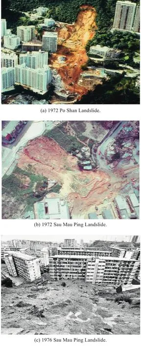
Fig. 1. The fatal landslides at Po Shan Road and Sau Mau Ping in the 1970s.

Fig. 2. The 1999 natural terrain landslide at Sham Tseng San Tsuen.
2. The Landslip Preventive Measures Programme from 1977 to 1994
In the aftermath of the disastrous man-made slope failures in the 1970s, the Government embarked on a long-term slope retro fitting programme in 1977, known as the Landslip Preventive Measures (LPM) Programme, to deal with substandard man-made slopes. A catalogue of sizeable man-made slopes including cut slopes, fill slopes and retaining walls was compiled. Currently, there are about 60,000 man-made slopes registered in the New Slope Catalogue (Fig. 3). These slopes are mainly situated within developed areas or adjacent to traf fic routes over different geographical locations of Hong Kong.
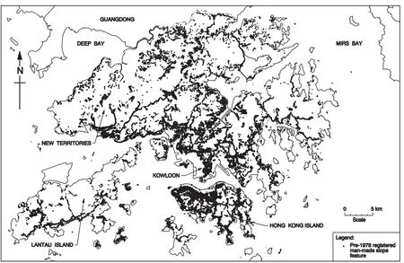
Fig. 3. Spatial distribution of the 60,000 man-made slopes in Hong Kong.
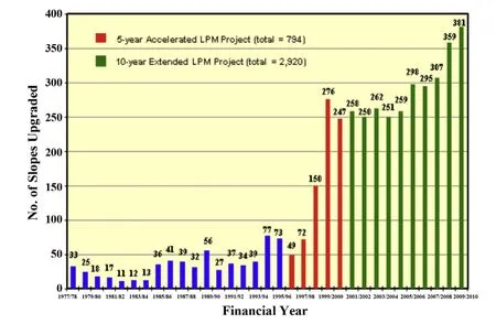
Fig. 4. Distribution of slopes upgraded under the LPM Programme from 1977 to 2010.
Initially, most of the slopes included in the LPM Programme were fill slopes affecting housing estates, schools and hospitals,mainly as a result of the two fatal landslides involving liquefaction of loose fill at Sau Mau Ping in 1972 and 1976, respectively. Since the mid-1980s, the proportion of soil cut slopes, rock cut slopes and retaining walls in the LPM Programme had increased. Up to 1994, a total of 620 slopes (Fig. 4) had been upgraded under the LPM Programme. In sum, the focus of the LPM Programme in this period, i.e. 1977-1994, was on treating man-made slopes affecting occupied buildings. The total expenditure involved was about HK$1200 million (Fig. 5).
In general, there are four stages in the design and construction of slope upgrading works under the LPM Programme. These include:

Fig. 5. Expenditure incurred under the LPM Programme from 1997 to 2010.
(a) Stage 1 - Preliminary study consisting of a site reconnaissance to identify slopes that require a detailed study. Where signs of immediate and obvious danger are identified, urgent repair works would be initiated.
(b) Stage 2 - Detailed study consisting of desk study, aerial photograph interpretation, site observations, stability analysis, and if necessary, ground investigation works to decide whether or not upgrading works are necessary. For private slopes, where there is primafacie evidence that the slope is dangerous or liable to become dangerous, a statutory repair order would be issued to the private owners concerned. This process is referred to as“safety screening”.
(c) Stage 3 - Design of slope upgrading works to bring the slope up to the required safety standards.
(d) Stage 4 - Construction of slope upgrading works including tender documentation, contract administration and site supervision.
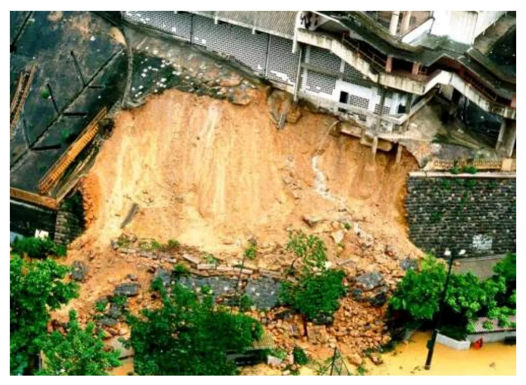
Fig. 6. The 1994 fatal landslide at Kwun Lung Lau.
3. Acceleration of the LPM Programme from 1995 to 2010
On 23 July 1994, a fatal landslide occurred below Block D of Kwun Lung Lau, Kennedy Town (Fig. 6). Five people were killed and another three people were injured during the incident. In addition, about 3900 residents were temporarily evacuated overnight.A comprehensive investigation into the cause of the landslide was subsequently carried out by the GEO. An international renowned geotechnical engineering expert was engaged by the Government to conduct an independent review of the investigation (GEO,2000a). A Select Committee was established by the Legislative Council in 1994 to inquire into matters related to the fatal landslide.Prompted by the Kwun Lung Lau landslide, the Government initiated a Slope Safety Review at the end of 1994 to examine the policy,legislation and resources related to the prevention of landslides in Hong Kong, and to recommend improvement measures.
Following the investigation, inquiry and review, a number of recommendations to improve the slope safety system were made. One of the recommendations was to accelerate the LPM Programme. Following acceptance of the recommendations, the Government launched the 5-year Accelerated LPM Programme in April 1995. The target was to complete the upgrading works for about 800 substandard government man-made slopes and to carry out safety screening studies for 1500 private man-made slopes. To ensure that the most deserving slopes are selected for action under the Programme, a risk-based priority ranking system incorporating the results of quantitative risk assessment (QRA), and the experience and technical know-how in landslides accrued over the years was adopted (Wong, 2005). The risk-based priority ranking system takes account of both the likelihood of landslide and the consequence of the slope failure. A total score which reflects the risk of the slope is obtained by the product of instability score and consequence score. The instability score is determined by a number of factors including age of slope, level of geotechnical input during the formation of the slope, slope geometry, signs of distress, records of instability and other characteristics. The consequence score is determined by the type and proximity of the facilities affected, the probable scale of failure and the topography adjacent to the slope.
Over the 5 years from 1995 to 2000, a total of 794 slopes were upgraded under the LPM Programme (Fig. 4). The total expenditure involved is about HK$ 2930 million (Fig. 5). At the end of the 5-year Accelerated LPM Programme, about 250 slopes were upgraded each year which is about five to six times the average productivity before 1995. It is worth noting that QRA has been applied at that time to evaluate and monitor the performance of the LPM Programme.An assessment made in 2000 found that the overall landslide risk posed by pre-1977 man-made slopes was reduced to 50% of the level existed in 1977 upon completion of the 5-year Accelerated LPM Programme (Cheung and Shiu, 2000).
As part of the Government’s long-term strategy to improve slope safety in Hong Kong, the 10-year Extended LPM Programme was launched in 2000 upon completion of the 5-year Accelerated LPM Programme. The annual output under the 10-year Extended LPM Programme was to upgrade 250 government man-made slopes and to carry out safety-screening studies on 300 private man-made slopes. The aim was to reduce the landslide risk posed by pre-1977 man-made slopes to 25% of the level in 1977 (Cheng, 2011). The 10-year Extended LPM Programme was successfully completed in 2010, and this has brought about substantial improvement in the safety of slopes and a significant reduction in the number of fatal landslides in recent years.
During the period from 1977 to 2010, about 4500 substandard government man-made slopes were upgraded under the LPM Programme (Fig. 4). The average number of slopes upgraded from 1977 to 1994 was about 35 per year and this had progressively increased to 250 per year during the 5-year Accelerated LPM Programme. The average number of slopes upgraded per year under the 10-year Extended LPM Programme had further increased to 300.
The cumulative expenditure incurred under the LPM Programme from 1977 to 2010 was about HK$ 14 billion (Fig. 5). Before the 5-year Accelerated LPM Programme, the annual expenditure was about HK$ 60 million. Over the 5 years from 1995, the expenditure had increased geometrically until it reached the peak of about HK$ 900 million in 2000. In the next 10 years from 2000 to 2010,the average annual expenditure was about HK$ 950 million.
Apart from LPM upgrading works, enhanced maintenance (EM)works, generally by means of prescriptive measures, were carried out on some 5000 selected old slopes maintained by various government departments who are responsible for maintaining these slopes. This also helps achieve quick improvement to the stability of old substandard slopes.
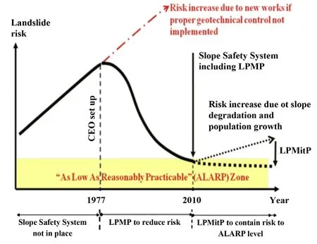
Fig. 7. Landslide risk profile of Hong Kong.
4. The post-2010 Landslip Prevention and MitigationProgramme
With the introduction of geotechnical control and the implementation of the LPM Programme, the landslide risk has decreased progressively and reached the “As low as reasonably practicable” (ALARP) zone in 2010 (Fig. 7). However, there is no room for complacency. If investment in slope safety is not maintained, the landslide risk will increase with time due to slope deterioration and encroachment of urban development or redevelopment upon steep natural hillside. This would cause, in addition to risk to life,significant economic losses and social disruption as a result of road blockages and building evacuation due to landslides, thereby compromising public safety, sustainable development and Hong Kong’s reputation as a modern metropolitan city and tourist hub.
The majority of the remaining landslide risk comes from about 15,000 man-made slopes with moderate risk affecting development and about 2700 natural hillside catchments (Fig. 8) with known hazards and close to existing buildings and important transport corridors. Therefore, the Government has implemented Landslip Prevention and Mitigation (LPMit) Programme since 2010 to dovetail with the 10-year extended LPM Programme. The strategy of the LPMit Programme is to contain this remaining landslide risk through rolling enhancement of man-made slopes and systematic mitigation of natural terrain landslide risk pursuant to the“react-to-known” hazard principle, i.e. to carry out studies and mitigation actions where significant hazards become evident. The annual target of the LPMit Programme is to complete the upgrading works for 150 substandard government slopes, carry out safety screening studies on 100 private slopes and carry out landslide risk mitigation works for 30 vulnerable natural hillside catchments from 2010 onwards.
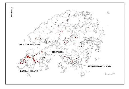
Fig. 8. Spatial distribution of the 2700 vulnerable natural hillside catchments.
5. Technical advancement in man-made slope upgradingworks
Slope upgrading works are substantial engineering works based on the principles of removal (e.g. cutting back the slope to reduce its gradient), reinforcement (e.g. strengthening slopes by installation of steel bars called soil nails), retention (i.e. supporting slopes with retaining structures), and replacement (e.g. excavating and reforming slopes with a denser surface soil layer). Combinations of different types of works may be used for upgrading man-made slopes. The design and construction practice for man-made slopes has evolved over time, as a result of the technical advancements made in respect of slope engineering and construction techniques.In particular, the findings of the systematic landslide investigation Programme initiated by the GEO since 1997 have contributed to achieving an improved understanding of the mechanisms and causes of slope failures. Areas for improvement in enhancing the slope engineering practice are identified, which are promulgated by Ho et al. (2002).
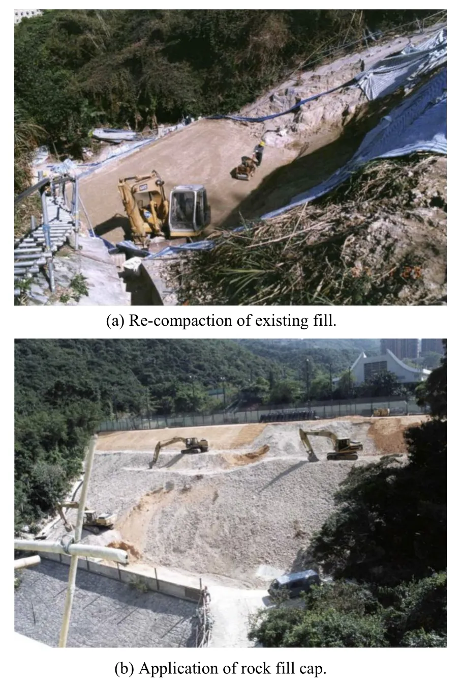
Fig. 9. Stabilization of fill slopes.
5.1. Fill slopes
Substandard fill slopes, typically comprising loose fill materials,are susceptible to liquefaction when they become saturated and subjected to shearing. The conventional method of treating these fill slopes is to excavate and re-compact the top 3 m of loose fill to achieve 95% relative compaction (Fig. 9a). This is based on the recommendations made by the independent review panel for fill slopes, which was set up following the 1976 Sau Mau Ping landslide(HKG, 1977). Most of the fill slopes under LPM Programme were upgraded by means of this method because of its effectiveness and reliable performance in improving the stability of the fill slopes. A variant to this method, which entails the use of rock fill or cement stabilized soil in place of compacted soil fill to form the 3 m cap,has been adopted in some cases (Fig. 9b).
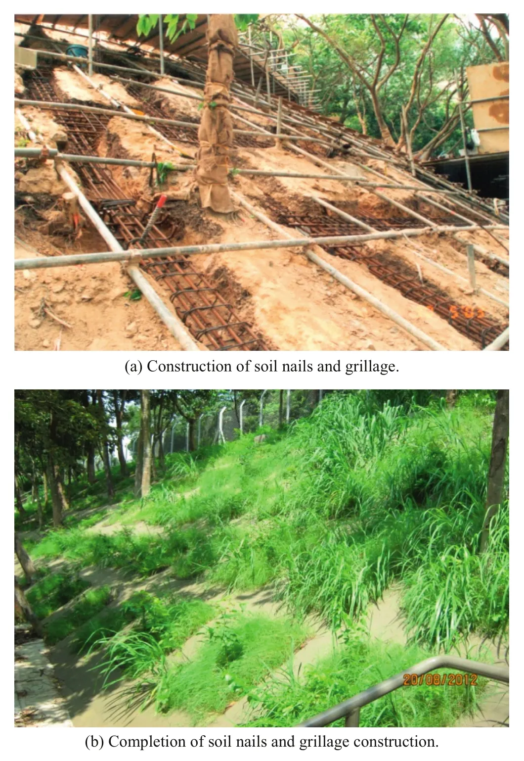
Fig. 10. Upgrading of loose fill slopes using soil nails and grillage.
5.2. Soil cut slopes
Before 1990, the usual method of improving the stability of a substandard soil cut slope was by trimming back the slope to a gentler profile (Koirala and Tang, 1988). The major construction activity involved is excavation and removal of soil materials from the slope. Because no special engineering techniques are needed,the construction cost is relatively cheap and easy to implement.Vegetation is used as the slope surface cover in order to make the slope look as natural as possible. Where there is insufficient space at the crest to accommodate the cut back profile, structural supports such as hand dug caissons and retaining walls would be used to improve the stability of the slopes (Powell et al., 1990).
Discussions on the reliability of the design of soil cut slopes were made in the 1980s (Malone, 1985). The profession recognized that there were uncertainties inherent in some of the important elements of a slope design such as the geological model, selection of slip surfaces, groundwater conditions and shear strength of the soil materials. Although the soil cut slopes are designed to the same factor of safety (FOS) derived from deterministic analysis, the reliability in terms of the probability of failure may vary significantly.Hence the mere demonstration of an adequate FOS carries with it no guarantee that the probability of failure is adequately low. It was necessary to improve the design of soil cut slopes that would give greater reliability and robustness for the same FOS.
Soil nailing, which comprises high yield steel reinforcing bars installed into the ground by means of drilling and grouting, was introduced in Hong Kong in the mid-1980s. The process of soil nailing is not very susceptible to weather conditions and there is flexibility to position the soil nails to avoid existing trees. The technique is simple and versatile compared with other structural solutions, rendering it adaptable to the physical constraints commonly encountered in slope sites. In addition, because soil nails are usually installed at close spacing, they can reduce the vulnerability of the slope to undetected weak geological zones and unfavourable relict joints by binding the soil together to form an integral mass. That means the design of soil-nailed cut slopes is less sensitive to adverse ground conditions. Following documentation of the design approach and the construction practice by Watkins and Powell (1992), soil nailing has been accepted as a robust and economical engineering solution for improving the stability of soil cut slopes in Hong Kong. In order to improve the soil nailing technology and rationalize the design standards, a series of studies were conducted by the GEO in the early 2000s. This involved literature review, field tests, laboratory investigations, physical modelling,numerical modelling and analytical study (Figs. 11 and 12). The findings from these soil nails studies have led to the publication of a guide on soil nail design and construction (GEO, 2008). It enhances the technical know-how of local engineers in the technique.
The use of soil nails in soil cut slopes has become increasingly popular. About 3400 and 2600 slopes have been upgraded using soil nails under the LPM Programme and EM Programme respectively up to 2010. Through theoretical studies and field observations, soil nailing is now recognized as a more robust and reliable scheme than cutting back in that the scheme is more resilient to local geological defects.
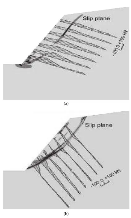
Fig. 11. Numerical modelling of soil nails with different inclinations.
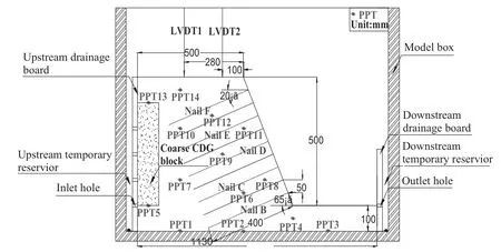
(a) Set-up of a nailed-slope model in centrifuge test.
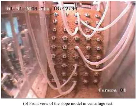
Fig. 12. Centrifuge modelling of a soil-nailed slope.
5.3. Retaining walls
Most of the substandard retaining walls are old masonry walls constructed during the period from 1850 to 1950. A number of fatal landslide incidents involving masonry walls had occurred in the history of Hong Kong. In 1925, a masonry wall at Po Hing Fong on Hong Kong Island collapsed, demolishing seven houses and killing over 70 people. Most recently in 1994, the failure of a 100-year old masonry wall at Kwun Lung Lau claimed the lives of 5 persons (Fig. 6). These tragic incidents have highlighted the need for understanding the structure and behaviour of old masonry walls so that appropriate stabilization measures can be carried out to improve their stability.
The assessment of stability of old masonry retaining walls is not simple because of their variable and non-monolithic construction.In order to tackle the problem, a comprehensive review on masonry retaining walls in Hong Kong, including the construction practice and structure of masonry walls, an examination of their structural behaviour, analyses of case histories of wall failures and suggestions on the approach to investigate stability of masonry walls, was carried out by Chan (1996). Further guidelines on the assessment of old masonry walls were given by GEO (2004) following a review of the lessons learnt from the Kwun Lung Lau landslide incident.
A special feature found on many old masonry walls in Hong Kong is the presence of “wall trees”, which refer to trees growing from the open joints or crevices between stone blocks. These“wall trees” constitute an important landscape element in the community and should be preserved where at all possible in view of their special amenity value. A study on masonry walls with trees was carried out by Wong and Jim (2011). The study concluded that the roots of wall trees would not induce failure of masonry walls.They would occasionally cause displacement of masonry blocks at the wall crest but the roots would also strengthen the wall face by providing a form of mesh reinforcement. However, wall trees would affect the stability of masonry walls due to its surcharge effect and this should be considered in the stability assessment. The study also identified suitable methods of stabilizing old masonry walls. One of the methods is to use soil nailing, which has the bene fit of preserving both the existing wall trees and the original masonry facade (Fig. 13b). Other methods include the provision of conventional buttresses or flying buttresses in front of the masonry wall, and the construction of hand-dug caissons behind the wall.
5.4. Rock cut slopes
The stability of rock slopes is mainly controlled by the characteristics and orientations of discontinuities within the rock mass, as well as the groundwater conditions. Detailed engineering geological mapping is required for the investigation, design and construction of rock slope stabilization measures. Very often, the design of the necessary works can only be finalized during the construction stage when safe access for close inspection of the rock face has been made available and obscuring vegetation and surface covers have been removed. The common stabilization measures for use in rock cut slopes include scaling, buttresses, dentition, dowels and rock bolts, drainage provisions and mesh netting. The design and construction practice for upgrading existing rock cut slopes under the LPM Programme was described by Dubin et al. (1986).
公司采用股份有限责任制,并根据公司发展特点,初期采取直线制管理。后期根据公司发展状况进行调整。公司所有权与经营权分离,实行总经理负责制。
In the design of rock slope stabilization works, it is important to identify laterally persistent discontinuities such as sheeting joints which are conducive to large-scale rock slope failures. However,dislodgement of small rock blocks by way of rotation, sliding or ravelling may occur as a result of progressive deterioration and/or development of cleft water pressures within adversely oriented joints. Although the chance of direct impact by a small rock fall is not high, the consequence in the event of direct impact may be very serious given the nature of the material. Therefore, extreme care should be taken to ensure that minor but kinematically critical joints are not overlooked during the design process. Based on the key lessons learnt from studies of engineered rock cut slope failures and a review of the practice for the investigation and design of rock cut slopes, technical guidance on enhancement of rock slope engineering practice was promulgated by Yu et al.(2005).
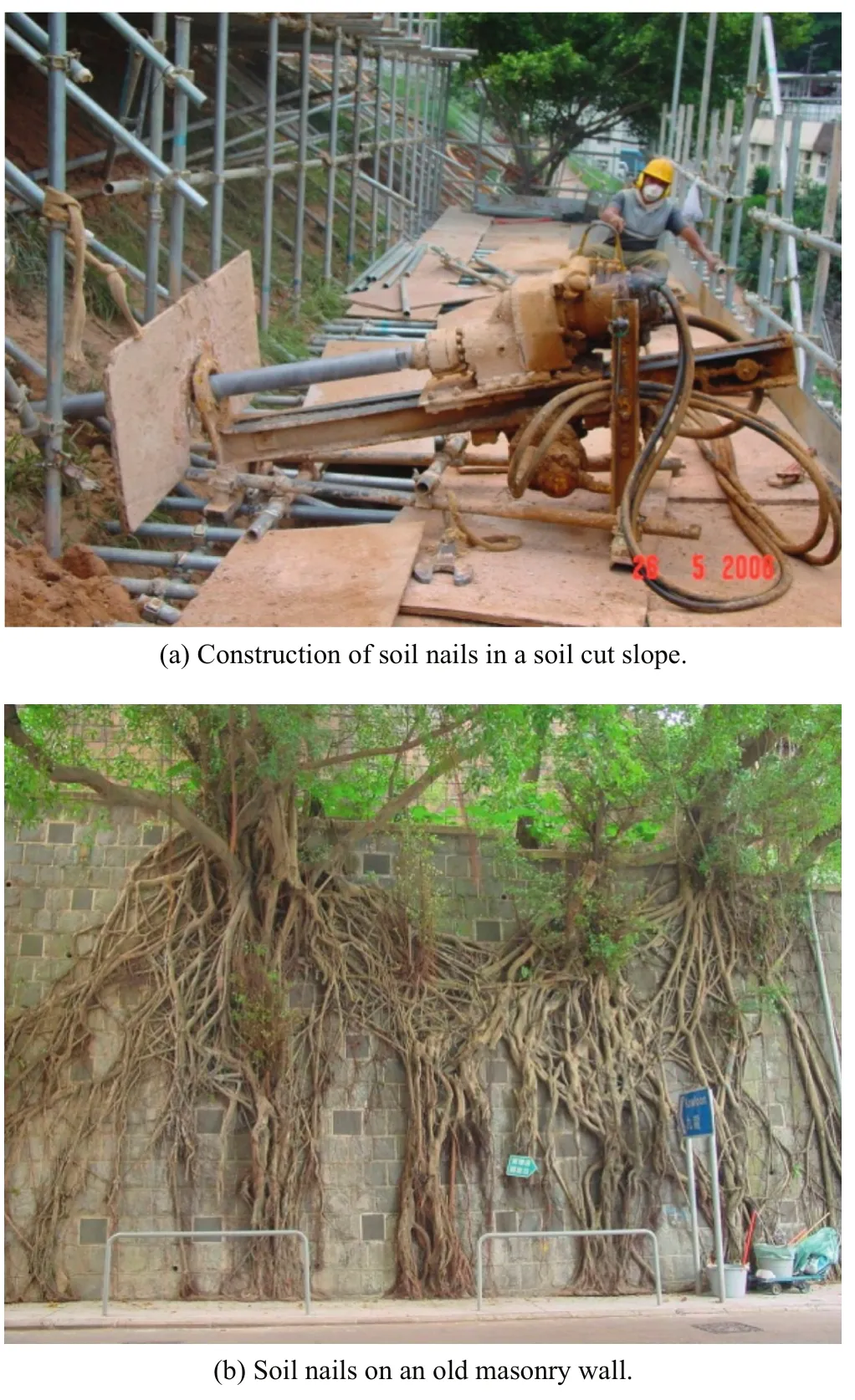
Fig. 13. Application of soil nailing technique in soil cut slopes and old masonry walls.
6. Technical advancement in natural terrain mitigation works
Natural terrain occupies an area of about 650 km2, which covers about 60% of the land area of Hong Kong. There is a high concentration of developments in Hong Kong mingled with man-made slopes and natural hillsides. The severe rainstorm of 7 June 2008 is a vivid reminder of the potential vulnerability of developments located close to natural terrain. To provide a dataset for planning of risk mitigation works, an inventory of hillside catchments with historical landslides that occurred close to existing buildings and important transport corridors has been compiled. The criteria are based on the proximity of the crown or toe of a landslide to an important facility. The inventory comprises about 2700 hillside catchments,scattered over different areas of Hong Kong (Fig. 8). A risk-based ranking system has been devised for establishing the priority of the 2700 hillside catchments for systematic follow-up action under the LPMit Programme.
In Hong Kong, natural terrain hazards have been grouped into five main hazard types on the basis of the mechanism of transportation, the nature of displaced material and the topographic location. These include open hillside landslide, channelized debris flow, deep-seated failure, boulder fall and rock fall. A natural terrain hazard study is carried out to formulate the geological and geomorphological model for the hillside and evaluate the hazards involved.Three different approaches, namely FOS, QRA and design event,may be used either individually or in combination for evaluation of natural terrain hazards. In practice, the majority of natural terrain hazard assessments are carried out using the design event approach. The FOS approach is used only if it is pragmatic and cost-effective to stabilize the natural hillside. QRA, fairly involved and costly, is adopted if rigorous quantification of the landslide risk or cost-benefit analysis of alternative risk mitigation strategies is required for the natural terrain concerned. Regardless of the approach adopted, the large areal extent of the natural hillsides means that only limited ground investigation and testing can be carried out during the process of natural terrain hazard studies. Therefore, geological and geomorphological inputs based on site-specific observations should be provided to complement the investigation. Technical guidance on natural terrain hazard assessment is given by Ng et al. (2003).
In the management of natural terrain risk under the LPMit Programme, the preferred approach is not to carry out extensive stabilization works to large areas of the natural hillside, which is impractical and environmentally damaging, but to mitigate the risk through the provision of defense measures to contain the landslide debris from the natural hillside above. In most cases, the defense measures adopted in Hong Kong consist of the provision of a concrete barrier at the toe of the natural hillside (Fig. 14). A review of the local and international natural terrain landslide risk mitigation strategy and practice was carried out by Shum and Lam (2011).As part of the review, a number of established techniques not commonly used in Hong Kong have also been examined. Some of these techniques including flexible debris-resisting barriers, transport channels and debris-straining structures would have potential applications to certain natural terrain landslide problems in Hong Kong.
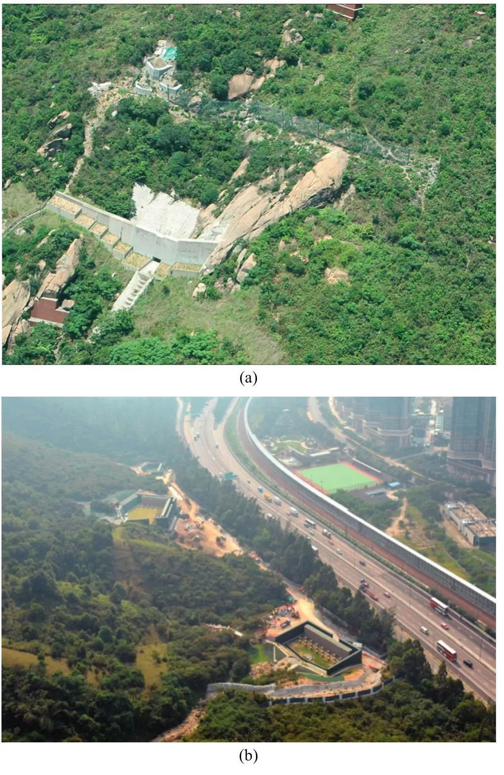
Fig. 14. Concrete barrier at the toe of a natural hillside.
6.1. Debris mobility modelling
One of the important factors affecting the design of defense works is debris mobility. This requires the use of dynamic analysis to assess the probable distance of debris runout and debris velocity of natural terrain landslides, based on continuum models which have been calibrated against field observations. These continuum models utilize the principles of conservation of mass,momentum and energy to describe the dynamic motion of landslide debris and incorporate a rheological model to represent the flow behaviour of the landslide debris. The findings of a study of the mobility of natural terrain landslides in Hong Kong by Ayotte and Hungr (1998) concluded that the frictional rheology and Voellmy rheology can be used to estimate the mobility of open hillside landslides and channelized debris flows (CDFs),respectively. A set of conservative material parameters for debris mobility analysis in Hong Kong, including the apparent friction angle for the frictional rheology and the apparent friction angle and turbulence coefficient for Voellmy rheology were recommended.
However, the natural terrain landslides triggered by the 7 June 2008 rainstorm have provided plenty of additional information and data on debris movement. Back-analysis of selected CDF triggered by the 7 June 2008 rainstorm carried out by GEO showed that about 1% of the CDFs were more mobile than that predicted using the Voellmy parameters recommended by Ayotte and Hungr (1998).Based on findings of the back-analysis, supplementary guidelines on the assessment of mobility of CDFs are promulgated by GEO(2011).
The GEO has developed its own two-dimensional (2D) dynamic modelling algorithm, based on a formulation and solution methodology similar to that adopted in the DAN model formulated by Hungr (1995). The GEO has also developed a three-dimensional(3D) landslide runout simulation model based on the Particle-in-Cell technique (Kwan and Sun, 2007). Both modelling algorithms have been used to back analyze CDFs and open hillslope failures(OHF) in Hong Kong. The development of 2D and 3D numerical modelling of debris movement has greatly enhanced the capability of assessing debris influence zones and design of the corresponding risk mitigation works.
A benchmarking exercise on landslide debris mobility modelling was held in December 2007 in Hong Kong during the International Forum on Landslide Disaster Management (Hungr et al., 2007). It was participated by 13 groups of researchers and practitioners from different regions of the world including the GEO. A range of numerical models were used by the participants to complete the mobility analysis of selected benchmark cases. The outcome of this benchmarking exercise showed that the simulation results obtained by GEO’s 3D landslide runout simulation model were reasonably accurate compared with the corresponding analytical solutions, laboratory measurements and field observations. The results were also consistent with those determined from other numerical models by other participants,which would mean that the debris mobility modelling capability in Hong Kong is comparable to that in other technical leaders.
6.2. Flexible debris-resisting barriers
Flexible barriers, which are mainly formed of steel ring nets mounted between horizontal steel ropes spanning between steel posts and anchored into the ground, are one of the techniques that can be used to mitigate natural terrain landslides (Fig. 15a). The advantages of flexible barriers are that they are relatively easy to install on steep natural terrain, less visually obtrusive and have less environmental impact compared with reinforced concrete barriers.Whilst flexible barriers have been in use for over twenty years as a protective measure against boulder falls and rock falls, the application of flexible barriers for resisting the impact of natural terrain landslide debris is a relatively new concept.
The design methodology for flexible rock fall barriers is based on an energy approach whereby a falling rock or boulder is stopped in one go by the barrier designed to absorb the kinetic energy carried by the rock or boulder. The design usually entails the use of proprietary flexible barrier systems with specific energy absorbing capacities that are verified by full scale field testing in accordance with the relevant national or international standards. The technology involved is relatively mature. In contrast to a rock fall, the impact of landslide debris hitting a flexible barrier is delivered as consecutive pulses due to the compressibility and mobility of the debris. Therefore, the design methodology for rock fall barriers is not applicable to the design of flexible barriers as a debris resisting structure. So far, there are no national or international standards for the design of flexible debris-resisting barriers. Suggestions on the design approaches for flexible debris-resisting barriers were prepared by Kwan and Cheung (2012) based on a review of the present state of knowledge, which would serve as a useful reference for the relevant practitioners. Fig. 15b shows the establishment of a numerical model for a flexible debris-resisting barrier using a commercial software LS-DYNA in conjunction with the suggested force design approach.

Fig. 15. Flexible debris-resisting barrier.
6.3. Managing public expectation
Natural terrain mitigation works differ from slope upgrading works in that they would not stop the occurrence of landslides on the natural hillsides. Instead, they would only reduce the consequence of landslides. Muddy water and some debris could sometimes spill over to the roads and buildings they protect, which may still have to be closed temporarily for safety against risks remaining from the landslide scars. Furthermore, because of the variable nature of the natural terrain and the limitations in the current technology, the mitigation measures, which will contribute to reducing the consequence, may be overwhelmed under very severe or extreme rainstorms. Therefore, it is necessary to manage public expectation through public education so that the people of Hong Kong can be prepared for such situation.
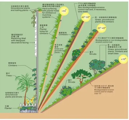
Fig. 16. Guidelines for planting on slopes.
7. Landscaping to slopes
It is government policy to make slopes look as natural as possible, blending them with their surroundings and minimizing their visual impact on the built environment. To pursue this policy, vegetation is used as slope surface cover in the upgrading of existing man-made slopes which are not steeper than 55°(Fig. 16). A hard surface cover such as chunam or shotcrete may be used for steeper slopes, but suitable landscape measures such as applying subdued colour, masonry facing and providing planter holes on the slope surface for screen planting are taken to minimize the visual impact(Fig. 17).
For natural terrain mitigation works, the extent of mitigation works is minimized as far as practicable to reduce disturbance to the hillside and the environment. The existing vegetation, including trees and shrubs, is also preserved whereas possible during the construction of landslide risk mitigation measures. Landscape treatments such as vertical greening, screen planting and toe planters (Fig. 18) would be provided to minimize the visual impact of the mitigation works and blend them with their surrounding environment.

Fig. 17. Landscaping to man-made slope with hard cover.
In 2000, the GEO produced a set of technical guidelines on landscape treatment and bioengineering for man-made slopes and retaining walls (GEO, 2000b). A review of the technical guidelines was carried out in 2010 with a view to promulgating the latest best practice and expanding the scope to include landscape treatments for natural terrain mitigation works and landslide repairs.The review has culminated in the new GEO Publication No. 1/2011“Technical Guidelines on Landscape Treatment on Slopes” (GEO,
2011).
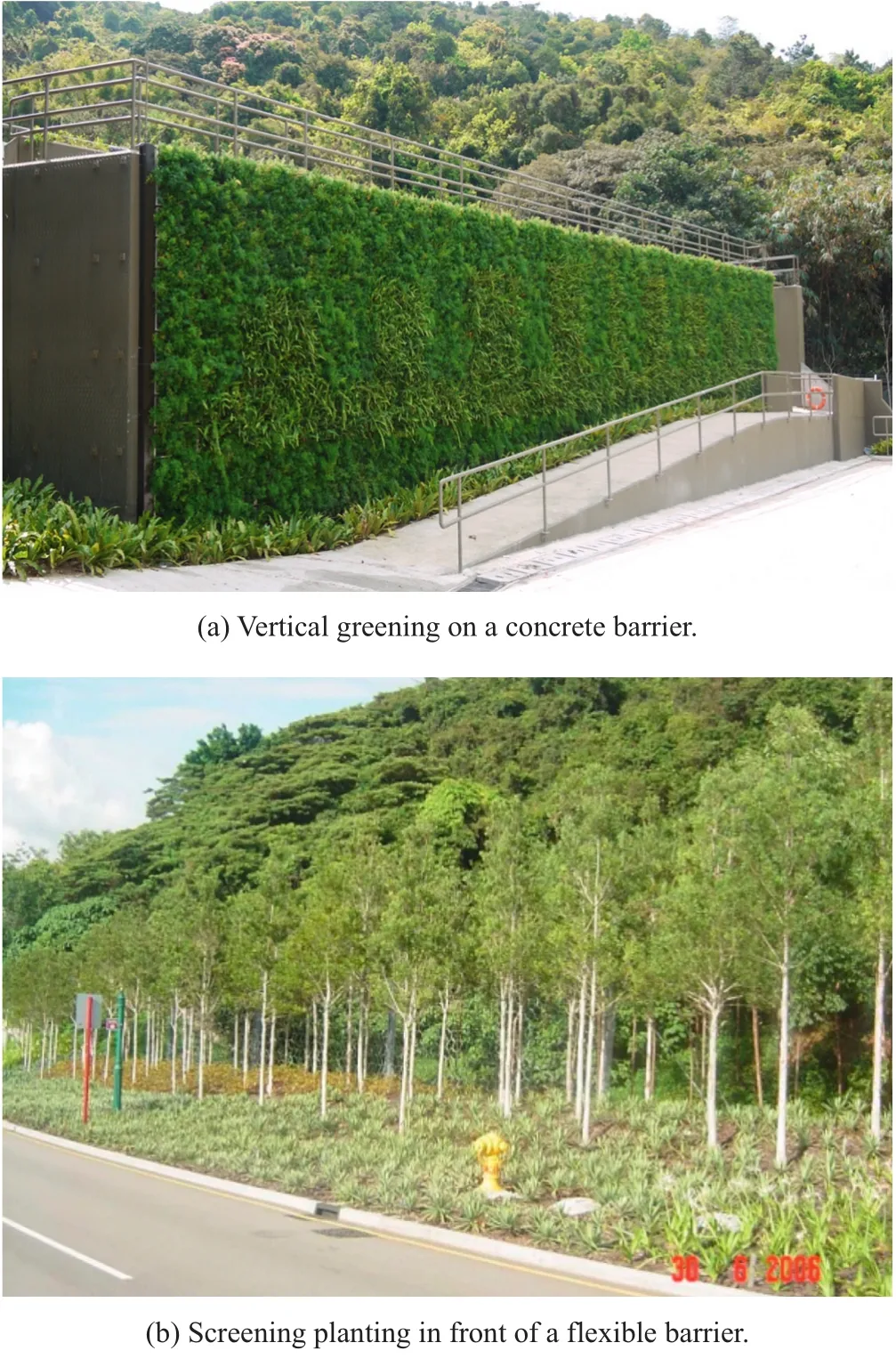
Fig. 18. Landscaping to natural terrain mitigation measures.
Apart from slope appearance, we are mindful of the ecological impact of slope works. The GEO has put in effort to achieve ecological enhancement of slope works by using native species. A good example is the adoption of ecological planting in upgrading 24 man-made slopes along South Lantau Road between 2001 and 2004 (Fig. 19). Native species, either planted alone or when mixed with exotic species, would attract local wildlife including birds and insects which may act as seed dispersers to enrich the plant biodiversity. A bio-diversified vegetation cover is ecologically stable and hence more sustainable. Good practice on ecological planting for man-made slopes and engineering works for natural terrains with native species is given in GEO Publication No. 1/2011 (GEO,
2011).

Fig. 19. A success example to landscape the slopes along South Lantau Road.
As part of the continuous improvement in landscape treatment of slopes, the GEO has been researching into the use of vegetation in slope works and experimenting with new techniques of providing erosion control measures and vegetation covers to steep slopes, with due regard to safety, cost, aesthetic quality, and longterm maintenance requirements. Since 2002, the GEO has set up a database called “Greening Methods on Slopes” to co-ordinate updates of the information on the different new greening techniques that have been tried on Government slopes. Studies have been undertaken to assess the performance of different greening techniques and to identify vegetation species that can successfully establish and self-sustain on steep slopes. In collaboration with the Kadoorie Farm and Botanic Garden, the GEO has carried out a planting trial of native small tree and shrub species on steep slopes.The results of the studies and the planting trial provide useful information for further research into the establishment of robust,cost-effective, and eco-friendly vegetation covers on man-made slopes. Further studies on the application of various vegetation species for greening of man-made slopes were completed in 2007 and 2011, respectively, which have expanded the range of suitable vegetation species for landscape use on man-made slopes.
8. Conclusions
Hong Kong is unique in the world in terms of its combination of high seasonal rainfall and close proximity of dense urban development to steep terrain. As a result, landslides are one of the common natural hazards in Hong Kong. Some of the past landslides had caused widespread damage and many casualties, together with significant economic losses and social disruption. Through sustained efforts to prevent landslide disasters by means of slope engineering works over the past 35 years, the overall landslide risk posed to the community of Hong Kong has been substantially reduced. This is corroborated by the declining trend of landslide fatality rate since 1977.
Under the current LPMit Programme, about half of the funding resources will be allocated to natural terrain risk mitigation works.The philosophy and technology for dealing with man-made slope features and natural terrain landslide hazards differ significantly.The limited size of man-made slopes permits a level of ground investigation and testing sufficient for deterministic analysis and design. The technology is relatively well established. In contrast,natural terrain hazards studies require plenty of geological and geomorphological analyses with limited ground investigation and testing. The objective of mitigation works is to divert or contain landslide debris instead of preventing failure, which involves evaluation of debris movement down the slope and its interaction with the mitigation measures. The technology is still evolving. Further development work is being carried out in order to enhance the reliability, cost-effectiveness and buildability of natural terrain mitigation measures.
Apart from keeping the slopes safe, it is necessary to make them look as natural as possible in order to create a safer and better living environment for the people of Hong Kong. Landscape design is treated as an essential part of the design of upgrading works for man-made slopes and natural terrain hazard mitigation works.Input by professional landscape architects is provided at the early stage of the design process to ensure that landscaping input is integrated with geotechnical input. Where appropriate, native species are used in the landscaping works in order to create a visually acceptable and ecological sustainable slope environment.
Sustained development in Hong Kong requires continued vigilance and perennial attention in respect of landslide risk management. Notwithstanding this, absolute slope safety is not practical or achievable due to many uncertainties inherent in the variables including geological settings, properties of soil and rock,rainfall pattern and groundwater conditions. Hence, it is necessary to promote an accurate understanding of the nature of landslip danger in Hong Kong in order to enable the public to develop a realistic expectation for slope safety. This would reduce the likelihood of public over-reaction in future landslips and maintain community’s support and trust in the implementation of the landslip prevention and mitigation works.
Acknowledgements
This paper is published with the permission of the Head of the Geotechnical Engineering Office and the Director of Civil Engineering and Development, Government of the Hong Kong Special Administrative Region.
Ayotte D, Hungr O. Runout analysis of debris flows and avalanches in Hong Kong.Hong Kong: Geotechnical Engineering Office, HKSAR Government; 1998.
CEDD. When hillside collapse: a century of landslides in Hong Kong. Hong Kong:Civil Engineering and Development Department, HKSAR Government; 2005.
Chan YC. Study of old masonry retaining walls in Hong Kong (GEO Report No. 31).Hong Kong: Geotechnical Engineering Office, HKSAR Government; 1996.
Cheng PFK. Assessment of landslide risk posed by man-made slopes as of 2010 (Special Project Report No. SPR 1/2011). Geotechnical Engineering Office, HKSAR Government: Hong Kong; 2011.
Cheung WM, Shiu YK. Assessment of global landslide risk posed by pre-1978 manmade slope features: risk reduction from 1977 to 2000 achieved by the LPM Programme (GEO Report No. 125). Hong Kong: Geotechnical Engineering Office,HKSAR Government; 2000.
Dubin BI, Watkins AT, Chang DCH. Stabilisation of existing rock faces in urban areas of Hong Kong. In: Proceedings of the conference on rock engineering and excavation in an urban environment. Hong Kong: The Hong Kong Institution of Engineers; 1986. p. 155-71.
FMSWJV. Report on the debris flow at Sham Tseng San Tsuen of 23 August 1999(GEO Report No. 181). Fugro Maunsell Scott Wilson Joint Venture. Hong Kong:Geotechnical Engineering Office. HKSAR Government; 2005.
GEO. Guidelines for assessment of old masonry retaining walls in geotechnical studies and for action to be taken on private walls (GEO circular no. 33). Hong Kong:Geotechnical Engineering Office, HKSAR Government; 2004.
GEO. Guide to soil nail design and construction (Geoguide 7). Hong Kong: Geotechnical Engineering Office, HKSAR Government; 2008.
GEO. Report on the Kwun Lung Lau landslide of 21 July 1994 (GEO Report No.103). Hong Kong: N.R. Morgenstern & Geotechnical Engineering Office, HKSAR Government; 2000a.
GEO. Technical guidelines on landscape treatment and bio-engineering for manmade slopes and retaining walls (GEO Publication No. 1/2000). Hong Kong:Geotechnical Engineering Office, HKSAR Government; 2000b.
GEO. Technical guidelines on landscape treatment for slopes (GEO Publication No.1/2011). Hong Kong: Geotechnical Engineering Office, HKSAR Government;2011.
HKG. Report on the slope failures at Sau Mau Ping. Hong Kong: Government of Hong Kong; 1977.
HKIE. Soil nails in loose fill slopes (a preliminary study) - final report. Hong Kong:Geotechnical Division, The Hong Kong Institution of Engineers; 2003.
Ho KKS, Sun HW, Hui THH. Enhancing the reliability and robustness of engineered slopes (GEO Report No. 139). Hong Kong: Geotechnical Engineering Office,HKSAR Government; 2002.
Hungr O. A model for the runout analysis of rapid flow slides: debris flows and avalanches. Canadian Geotechnical Journal 1995;32(4):610-23.
Hungr O, Morgenstern NR, Wong HN. Review of benchmarking exercise on landslide debris runout and mobility modeling. In: Proceedings of the 2007 international forum on landslide disaster management. Hong Kong: The Hong Kong Institution of Engineers; 2007. p. 755-812.
Koirala NP, Tang KY. Design of landslip preventive works for cut slopes in Hong Kong.In: Proceedings of the fifth international symposium on landslides. Lausanne,Switzerland: A.A. Balkema; 1988. p. 933-8.
Kwan JSH, Sun HW. Benchmarking exercise on landslide mobility modeling-runout analyses using 3dDMM. In: Proceedings of the 2007 international forum on landslide disaster management. Hong Kong: The Hong Kong Institution of Engineers;2007. p. 945-66.
Kwan JSH, Cheung RWM. Suggestions on design approaches for flexible debrisresisting barriers (GEO Discussion Note 1/2012). In: Hong Kong: Geotechnical Engineering Office. HKSAR Government; 2012.
Malone AW. The reliability of the design of cuttings in Hong Kong (GCO Discussion Note 5/85). In: Hong Kong: Geotechnical Engineering Office. HKSAR Government; 1985.
MFJV. Final report on the compilation of the enhanced natural terrain landslide inventory. Hong Kong: Maunsell Fugro Joint Venture. HKSAR Government:Geotechnical Engineering Office; 2007.
Ng KC, Parry S, King JP, Franks CAM, Shaw R. Guidelines for natural terrain hazard studies (GEO Report No. 138). Hong Kong: Geotechnical Engineering Office,HKSAR Government; 2003.
Powell GE, Tang KW, Au-Yeung YS. The use of large diameter piles in landslip prevention in Hong Kong. In: Proceedings of the tenth Southeast Asian geotechnical conference; 1990. p. 197-202.
Shum LKW, Lam AYT. Review of natural terrain landslide risk management practice and mitigation measures (GEO technical note 3/2011). Hong Kong: Geotechnical Engineering Office, HKSAR Government; 2011.
Watkins AT, Powell GE. Soil nailing to existing slopes as landslip preventive works.Hong Kong: Hong Kong Engineer; 1992. p. 20-7.
Wong CM, Jim CY. Study on masonry walls with trees (GEO Report No. 257). Hong Kong: Geotechnical Engineering Office, HKSAR Government; 2011.
Wong HN. Landslide risk assessment for individual facilities. In: Proceedings of international conference on landslide risk management. Vancouver, Canada: Taylor& Francis Ltd.; 2005. p. 237-96.
猜你喜欢
杂志排行
Journal of Rock Mechanics and Geotechnical Engineering的其它文章
- Easy profit maximization method for open-pit mining
- A discontinuum-based model to simulate compressive and tensile failure in sedimentary rock
- Easy profit maximization method for open-pit mining
- Reply to Discussion on “A generalized three-dimensional failure criterion for rock masses”
- Discussion on “A generalized three-dimensional failure criterion for rock masses”
- Effects of physical properties on electrical conductivity of compacted lateritic soil
