缅甸Tarlay 2011年地震与古特提斯缝合带的活动构造
2012-09-20HLAHLAAUNG
缅甸Tarlay 2011年地震与古特提斯缝合带的活动构造
E-mail: hhlaaung@gmail.com.
0 Introduction
The eastern Myanmar can be tectonically divided into two terranes: Shan Massif in the west and the Than Lwin fold belt to the east. The Than Lwin suture zone is located between Loi-se-Loi-len fault and Chiang Rai Tectonic Line. Southeastward extrusion of the Indochina plate controls the active tectonics of eastern Myanmar. The satellite imagery of the Shan plateau (eastern Myanmar) shows a bookshelf-pattern of conjugate active strike-slip faults arranged in parallel in NE-or ENE-WSW direction. Structurally, the eastern Myanmar belongs to the Indochina plate which is between the Red River fault and Papun – Three Pagoda fault. The topographic image in Paleo-Tethys suture zone is charaterized by sigmoidal wrench structures and is interpreted by the previous authors as the trace of the Indosonian fold belt of Late Triassic age. The folds turn abruptly northeastward approaching the Red River fault, forming a large V-shaped regional structure pointing towards southeast. The sigmoidal wrench structures and the sigmoidal bends may be a result of offset and drag along the Red River suture during extrusion of Indochina plate in 15 Ma to 35 Ma (Rangin, 1996-1999). Their shape may be inherited from the orgional grain of the Indosinian fold belt which marked the site of closure of Paleo-Tethys Ocean in Late Triassic-Jurassic age.
1 Active Tectonics in the suture zone
A detailed morphotectonic study was carried out in the area using satellite image of 1:24,000 scale aerial photographs and 1:63360 scale topographic maps,to correlate the seismicity with tectonics. From these studies, it is found that there are two prominent lineaments striking in NE-or ENE- and N-S or NNE-direction. The geomorphology of the Than Lwin suture zone indicates a youthful topography characterized by deep gorges, narrow V-shaped valleys, rapids and waterfalls and the sharpness of structural features,suggesting that this region might be undergoing drastic deformation since Neogene. From the studies of satellite images, several lineaments are visible and detailed mapping of these lineaments show the major NE-SW or ENE-WSW trending fabric of the Than Lwin fold belt, the location of the Nan Ma fault, and numerous other ENE-WSW striking faults. Strike-slip faults in ENE-WSW direction and normal faults in NE-to NNE-striking direction represent themselves as tectonic lineaments within the broad, seismically active belt of Than Lwin suture zone. NW-SE extension is evident by the occurrence of brittle normal faults and NE-to ENE-oriented sinistral strike-slip fault.Within this zone is the trace of regional compression in a NE-SW direction. This region is presently undergoing active tectonic deformation, as indicated by current seismicity and earthquake focal mechanism solution. Map of active faults has been drawn based on Landsat TM images. Several NE-to ENE-oriented sinistral strike-slip faults that appear to be active on Landsat images are Mae Chan fault, Nan Ma fault,Menxing fault, Jinghong fault, Menglian fault and Nanting fault in the north (Fig.1). These active faults are probably results from bookshelf faulting due to present NW-SE right-lateral shear parallel to the Red River fault. Several zones of aligned short fault segments arranged in left-stepping en echelon pattern may represent late-Cenozoic sinistral slip of through-going fault system. Between these fault segments of a fault zone, many of localized pull-apart basins occur at fault bends or near the tips of the fault segment of NE- to ENE-trending sinistral faults. These basins are Kyaing Ton basin, Mongphat basin, Mong Yong basin, Tarlay basin and Tar-chi Leik basin.
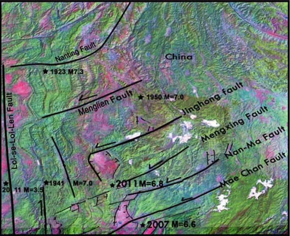
Fig. 1 Map showing active tectonic lineaments on Landsat TM imageries between latitudes 20° N-24° N, longitudes 98°E- 102°E in eastern Myanmar. Sharpness of their traces and seismicity provide information on the active deformation within the tectonic zone
Active tectonics over much of eastern Myanmar are compatible with NE-SW-striking maximum stress and minimum stress striking NW-SE. In eastern Myanmar, ENE- or NE-oriented faults that dominate the crustal fabric are active as indicated by their sharpness of their traces on satellite imagery and the seismicity. Le Dain et al. (1984) summarized the historical earthquakes of Myanmar in which earthquake of 26 December 1941, M=7; 16 April 1941, M-7;2 February 1950, M=7.0 respectively occurred within the broad seismically active belt. Laos earthquake of 16 May 2007 with M=6.3 occurred near Mae Chan fault. The recent Tarlay earthquake of 24 March 2011(M=6.8) occurred on the Nan Ma fault in eastern Myanmar. Another earthquake occurred near the trace of Loi-se-Loi-len fault, 25 miles northeast of Nam Sam (Southern Shan State) on 8 November 2011 with magnitude 3.5 and an earthquake with magnitude 3.8 occurred 25 miles NE of Kun Hing (Southern Shan State) near a fault very close to Than Lwin River. An earthquake with magnitude 3.1 occurred on 27 June 2012 at 20 mile northwest of Tar-chi-leik (Southern Shan State). Numerous events of earthquakes and geometry on active faults clearly show that the active tectonics of this region is dominated by strike-slip faulting and normal faulting. The stress fields of the region from the studies of focal mechanism solution of earthquakes (CMT from Harvard and epicenters from Engdhal, GIAC Report, Rangin 1996-1999) indicate that this area has been undergoing NW-SE extension and NE-SW compression.
2 Coseismic effects of the 2011 Tarlay Event
The most common coseismic features were sand boils, ground rift, rise of ground, ground subsidence.All these phenomena appear either together, in isolated spots or in linear structures. There were ground surface cracks in many places. Sand boil and gushing water are often associated with ground rifts. The volume of sand extruded was large and found in the paddy fields. In Tarlay, many ground fissures appeared on the Tarlay Road. Graben-like step depression was formed between two ground rifts. Wells overflowed,some fell in, and some subsided in many places. Liquefaction affected many paddy fields mostly in Tarlay,Kyar-ku-ni and Nar Yawng villages. Morphological changes leading to migration of spring from Nar Yawng village to Kyar-ku ni village and sinking of the ground are found in the area due to this earthquake event. Serious damage, such as building collapse, slant split are found in the region. The houses near the road were out of the perpendicular and slant split. At the sides of the road, a step zone occurred. A ground fissure system appeared on the Tarlay Road. Ground displacements are found in the paddy field. The surface deformation is characterized by left-lateral strike-slip faulting with horizontal displacement of 12 km on the Mekong River (Source: EOS). The geological structure around the town is complex. Mong Lin, Nar Yawng, Kya-Ku-Ni village-tracts are among the most affected areas. The shock was felt in Northern Thailand in the south and Laos in the east. The Salween and the Mekong rivers are among the five rivers, the general drainage from Tibetan plateau during the Neogene after the close of Himalayan movements(Chhibber, 1934). If a crude estimate for the maximum ages of these drainages is taken as Pleistocene (or approximately 1.8 Ma), the 12 km offset of the Mekong river by this event (Source: EOS) indicates 7 mm slip rate.
3 Possible style of deformation
The damage was distributed linearly north and south of the epicentre. Some of the ground seismic damage appears over a large area. Buildings are damaged in different ways. Some buildings collapsed,some split open and others settled unevenly. All of these reflected the different basic geological conditions. The factors controlling the damage caused by earthquakes are the characteristics of the geological structure. Earthquake damage is severe in regions near the Nan-Ma fault. The Nan Ma fault is 210 km long,trending ENE-WSW direction. It has a gently curved trace extending from the southern part of two basins located in south China and near its western end, and its trace form the northern border of the Tarlay basin where the NNE-oriented basin bounding normal fault joins another fault segment of the Nan Ma fault on the left. The Nan Ma fault accomodates the transfer of extension for the Tarlay basin. The earthquake amplification can only be the result of the coseismic slip which usually nucleates near the tip of one fault segment and tranfers to another fault segment on the left,which allows the movement along the normal fault in the fault zone. The fault is a simple transfer fault to accomodate differential motion between the two segments of the Nan Ma fault, arranged in left- stepping en echelon pattern. The fault is 60 km north of the Mae Chan fault which is also trending in NE- or ENE-WSW direction.
4 Conclusion
Earthquake disasters are related to the local site specific charateristics and seismic stress field. Coseismic changes like migration of spring and stream,sinking of the ground are common styles of deformation during compressional earthquake. The 2011 earthquake event showed that earthquake along an ENE-WSW striking Nan Ma fault was dominated by left- lateral strike-slip faulting, which in turn generated the movement along the NNE-SSW trending normal fault that bound the graben near Tarlay village.The focal mechanism solution of this earthquake suggests a strike-slip faulting. Therefore, the deformation mode for Tarlay area is inferred basically to be a combination of normal and strike-slip faulting. The frequency level of earthquakes in the past and the repeatability of the seismic hazards are important factors in determining the risk of earthquake hazards.
LE DAIN A.Y, TAPPONIER P, MOLNAR P. 1984. Active faulting and tectonics of Burma and surrounding regions. J. Geophys.Res., 89(BI): 453-473.
RANGIN C et. al. GIAC Report,1996-1999.
The 2011 Tarlay Earthquake and Active Tectonics in Paleo-tethys Suture Zone in Myanmar
Hla Hla AUNG
Myanmar Earthquake Committee, MES Building, Hlaing University Campus, Hlaing Township, Yangon, Myanmar
An earthquake of 6.8 magnitude struck the eastern Shan State in Myanmar at 20:29:30 Myanmar Standard Time (01:55:12 PM UTC) on 24 March 2011. It is one of the earthquakes in plate-interior setting. Six after-shocks occurred the same year. The nucleation point of this earthquake was defined by an epicenter at 20 km west of Tarlay (20.705°N, 99.949°E) at a depth of 10 km and its magnitude was 6.8. The earthquake damage was disastrous. The geological disasters were linearly distributed along the surface rupture zone. The earthquake produced cracks, arch bend, erupting sand, gush water, etc. in many places. As a result of this strong earthquake,224-305 houses were seriously damaged, 74 people were killed, 124 injured. The event was named after the nearest village Tarlay and the NE-or ENE-striking Nan Ma fault was responsible for it. A detailed morphotectonic study was carried out in the area using satellite image 1:24,000 scale aerial photographs and 1:63360 scale topographic maps, to correlate the seismicity with tectonics. It is found that there are two prominent lineaments striking in NE-or ENE- and N-S or NNE- SSW direction. The present-day deformation of the Than Lwin suture zone is consistent with roughly NW-SE extension and NE-SW striking compression, but with more conjugate strike-slip faulting and only minor normal faulting.
Tarley Earthquake; Active tectonics; Myanmar; Paleo-Tethys suture
10.3975/cagsb.2012.s1.03