Two-dimensional physical habitat modeling of effects of habitat structures on urban stream restoration
2011-08-16DongkyunIMHyeongsikKANG
Dongkyun IM, Hyeongsik KANG*
1. Water Infrastructure Division, Samsung C & T Corporation, Seoul 1321-20, Korea
2. Division of Water and Environment, Korea Environment Institute, Seoul 122-706, Korea
Two-dimensional physical habitat modeling of effects of habitat structures on urban stream restoration
Dongkyun IM1, Hyeongsik KANG*2
1. Water Infrastructure Division, Samsung C & T Corporation, Seoul 1321-20, Korea
2. Division of Water and Environment, Korea Environment Institute, Seoul 122-706, Korea
River corridors, even if highly modified or degraded, still provide important habitats for numerous biological species, and carry high aesthetic and economic values. One of the keys to urban stream restoration is recovery and maintenance of ecological flows sufficient to sustain aquatic ecosystems. In this study, the Hongje Stream in the Seoul metropolitan area of Korea was selected for evaluating a physically-based habitat with and without habitat structures. The potential value of the aquatic habitat was evaluated by a weighted usable area (WUA) using River2D, a two-dimensional hydraulic model. The habitat suitability forZacco platypusin the Hongje Stream was simulated with and without habitat structures. The computed WUA values for the boulder, spur dike, and riffle increased by about 2%, 7%, and 131%, respectively, after their construction. Also, the three habitat structures, especially the riffle, can contribute to increasing hydraulic heterogeneity and enhancing habitat diversity.
stream restoration; physical habitat; River2D; weighted usable area
1 Introduction
Urban streams provide not only aesthetic and economic values but also aquatic ecosystems. However, most urban streams have been degraded due to urban development. Urbanization has altered stream flow and channel geometry, and degraded water quality and ecology. In particular, channel morphology is modified by channelization, straightening, grading and paving of bank slopes, and removal of physical habitat.
Environmental improvements in urban streams are achievable through strategic methods that are different from those applied to unregulated streams. These methods include control of runoff and pollutant sources (Nolan and Guthrie 1998), reduction of peak flows (Harremoes et al. 1996), and physical habitat enhancements. A key to urban stream restoration is recovery of the physical habitat and maintenance of ecological flows sufficient to sustain aquatic ecosystems.
Aquatic ecosystems that include fish and benthic organisms can be limited by food, habitat, cover, substrate, flow and depth fluctuations, and water quality. Each or any combination of these factors affects aquatic ecosystems. The physical habitat simulationsystem (Bovee 1982; Bovee et al. 1998) is a suite of numerical models that predict aquatic habitat quality in terms of changes of its physical properties (velocity, depth, and channel indices). There has been much criticism when physical habitat simulation results have been applied and interpreted without consideration of other limiting factors such as food availability and water quality. However, studies have shown that there is a positive relationship between outputs simulated by physical habitat models and observed distributions and abundance of fish (Jowett 1992; Railsback et al. 1993; Nehring and Anderson 1993; Bovee et al. 1994). Also, in recent years many researchers have studied fish habitat using physical habitat models (Lee et al. 2010; Mouton et al. 2007; Crowder and Diplas 2000; Im et al. 2011).
Improvement of physical habitat conditions for aquatic ecosystems should take into account natural recovery processes (Reice et al. 1990; Nagaya et al. 2008; Konrad 2009) and the biogenic capacity of nature to improve the stream by itself (White and Brynildson 1967). Both non-structural and structural approaches for the recovery of habitats adapted to target species have been proposed (Garcia 1995). The structures constructed for aquatic habitat enhancement generally have been current deflectors, riffles, boulders, backwaters, and bank covers. These structures change local hydraulic and geomorphologic characteristics, leading to either an improvement or a decrement of habitat quality and quantity under different stream conditions (Garcia and Gortazar 2006; Crowder and Diplas 2000). However, the quantitative evaluation of the flow change or environmental enhancement effects of such structures has never been carried out.
The objective of this study was to evaluate the enhancement effects of different habitat structures on habitat conditions. A physical habitat simulation of those structures provided predictions of the changes in fish abundance occurring with changes in flow. In this study, habitat improvement was evaluated by the instream flow incremental methodology (IFIM). This is a decision-support system designed to help natural resource managers and their constituencies determine the benefits or consequences of different water management alternatives. IFIM should primarily be considered a process for solving water resources allocation issues that involve concerns for river habitats (Bovee et al. 1998). IFIM can be used to determine ecologically acceptable discharge or to evaluate the effects of habitat structures. It is a series of concepts, techniques, and computer programs that combine channel morphology, flow characteristics, and biological preferences of target organisms in order to predict physical habitat gains or losses under new or modified flow regimes (Bovee 1982). In these ways, IFIM allows for comparison of useable habitats under different conditions and, thereby, for prediction of the success or failure of particular physical habitat structures.
2 Methodology
2.1 Study site
The Hongje Stream, a tributary of the Han River, was selected for the purpose ofevaluation of a physically-based habitat with and without habitat structures. The study site served as a representation of urban streams with decreased morphological and ecological diversities resulting from channel modifications. It is located in the Seoul metropolitan area, 4.7 km away from the confluence of the Hongje Stream and Han River (Fig. 1). The stream is a regulated river with an average bed slope of 0.48%, a design flood discharge of 280 m3/s, and a predominantly sand substrate. The majority of daily flow rates throughout the year do not exceed 0.6 m3/s, except in the rainy season. The habitat appeared to be monotonous owing to channelization, straightening, graded bank slopes, and paving with revetments. The Pale Chub (Zacco platypus) was selected as the target fish species for evaluation of the site’s physical habitat. The choice ofZacco platypuswas based on the following several factors: this species was confirmed to be dominant at the site, there are already many cases in which the habitat suitability indices (HSI) forZacco platypushave been developed and applied through various methods (Kim 1999; Sung et al. 2005), andZacco platypusis a native Korean species that is most commonly found in Korea’s rivers.
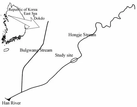
Fig. 1 Sketch of Hongje Stream and study site
2.2 River habitat model
River2D, a two-dimensional depth-averaged finite element model based on a conservative upwind Petrov-Galerkin method and developed by Steffler and Blackburn (2002), was used to simulate the river flow and fish habitat at the study site. The River2D model can simulate the transient flow between subcritical and supercritical flows. It also offers both wet and dry solutions by allowing for the change of surface flow equations to groundwater flow equations in dry areas. The governing equations employed in this study were shallow-water equations expressed in conservative form. The equations for the conservation of mass and two equations for the conservation of momentum are as follows:


wherexandyare the streamwise and transverse directions, respectively;UandVare the depth-averaged velocities in thexandydirections, respectively;His the water depth;qx(=UH) andqy(=VH) are the discharges per unit width in thexandydirections, respectively;gis the gravitational acceleration;ρis the water density;S0iandSfiare the bed slope and friction slope in theidirection (i=x,y), respectively; andτijis the component of the horizontal turbulent shear stress tensor (i,j=x,y).
River2D, developed specifically for use in natural and regulated rivers, simulates hydraulic characteristics and estimates population potentials for target species according to the weighted usable area (WUA). It incorporates a finite element method that is based on a conservative Petrov-Galerkin upwind formulation. It is characterized by the subcritical/ supercritical and wet/dry solution capabilities.
Fish and other aquatic organisms tolerate only certain ranges of current velocity, water depth, and bed substrate. Certainly, a key assumption of ecohydraulics modeling is that target species exhibit behavior reflecting quantifiable preferences for certain physical habitats. These habitat conditions are represented by HSI, which are preference curves indicating suitability on a scale of 0 to 1. As individual target species and life stages exhibit different habitat requirements, it is necessary to develop HSI relationships for each species and life stage. HSI have been derived from professional experience, various information sources, and field measurements. In this study,Zacco platypuswas selected as the target fish in an investigation of the impact of habitat structures on the physical habitat. For deriving the habitat suitability indices, substrate, velocity, and water depth were considered. Fig. 2 and Fig. 3 show the three habitat suitability indices forZacco platypusderived from field monitoring data. They are based on those developed by Kim (1999), and were somewhat modified taking into account the field observations by Sung et al. (2005).
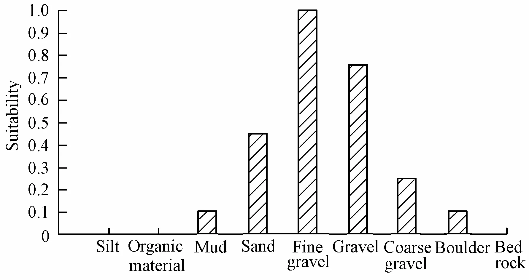
Fig. 2 Substrate preference forZacco platypusin Korea
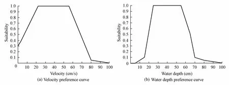
Fig. 3 Velocity and water depth preference curves forZacco platypusin Korea
3 Results and discussion
As the hydraulic model was applied to the steady-state flow, it was assumed that for each specific discharge, the hydraulic characteristic values did not change with time. This assumption is possibly invalid for some cases of downstream flood-wave propagation. The Hongje Stream was altered by channelization involved the installation of a sewage pipe, and thus has almost uniform discharge. The government decided to release the maintenance flow in order to sustain aquatic ecosystems. The maintenance flow discharge was 0.55 m3/s, and it was a significant discharge at the study site. The boundary conditions of the hydraulic model were derived using a rating curve developed from the field survey data obtained in the flood season.
Fig. 4 represents the geomorphology of the study site as recorded in field work undertaken prior to channel restoration. As can be seen, the topology of the channel is monotonous, and it seems that it is difficult to conserve the biodiversity of aquatic species. One of the simulation results can be seen in Fig. 5, where the contour plot indicates the water depth, and the vector is the velocity for the maintenance flow discharge of 0.55 m3/s. The water depth and velocity were almost 0.1 m and 0.2 m/s, respectively. These almost uniform values of water depth and velocity lead to degradation of the physical habitat conditions. Fig. 6 shows the distribution of the combined habitat suitability for the target fish. This suitability was calculated using the geometric mean of the depth, velocity, and substrate suitability. The calculated values were between 0 and 1, and the values closer to 1 represented more optimal physical habitats. In most regions, the computed combined suitability was below 0.1. This means that the habitat conditions of the river are seldom suitable for the target fish.
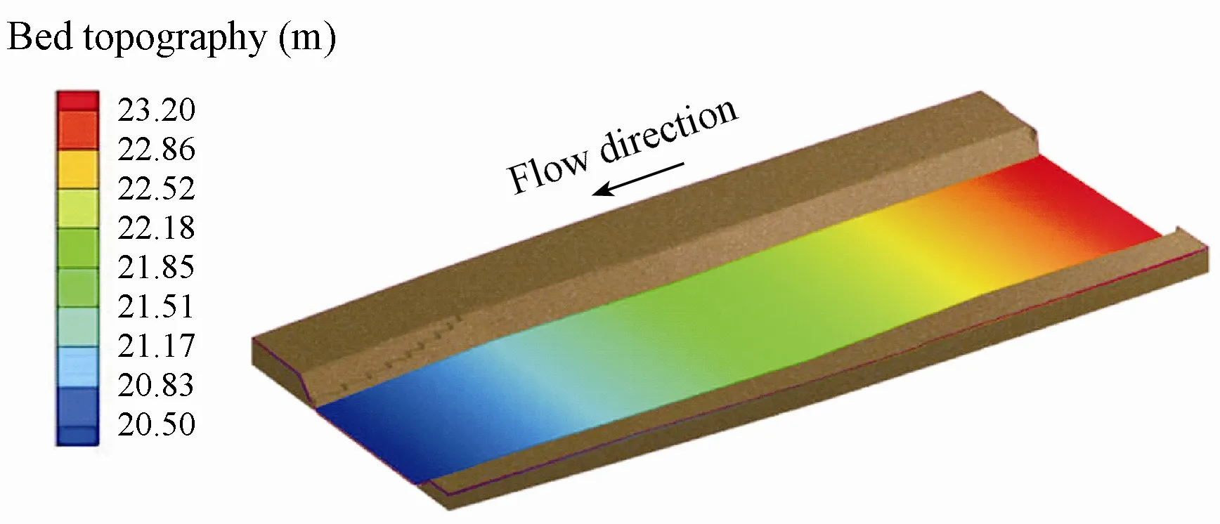
Fig. 4 Bed topography at study site
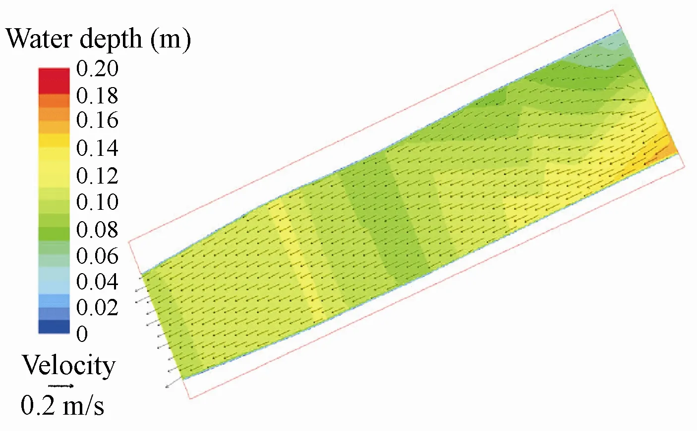
Fig. 5 Water depth contour and velocity vectors
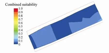
Fig. 6 Combined suitability without habitat structure
For the habitat enhancement, three different habitat structures, a boulder, a riffle, and a spur dike, were positioned on the previously unmodified channel bed (Fig. 7). The boulder shape was assumed, based on the field survey data, to be that of a regular hexahedron with a side length of 1 m. The riffle was hexagonal in shape, with an upstream face with a 10:1 slope, a crest of 20 cm, and a downstream face with a 16.7:1 slope. Also, the arm length of the spur dike was 5 m.

Fig. 7 Shapes of habitat structures for numerical simulations
Fig. 8 shows the distribution of the combined suitability after the construction of the habitat structures. The results for the boulder and spur dike (Figs. 8(a) and (c)) are similar to those for the previously unmodified stream (Fig. 6). For a given discharge, the WUA is calculated by summing the products of the cell areas and their respective combined suitability values. Fig. 9 shows the WUA changes with flow discharges for each structure. The WUA represents the physical habitat quantity in response to flow regimes. These curves are the key to assessment of the impact of proposed river restoration projects (Waddle 2001). At the study site, the average WUA increased by about 2% and 7% for the boulder and spur dike, respectively, with a discharge ranging from 0.55 to 15 m3/s. This is a reasonable result because these habitat structures have only a limited effect spatially. Thus, a group of boulders and dikes have greater influences on the improvement of fish habitat. Also, microhabitats formed by boulders provide localized refuges or reproductive habitats for a variety of other aquaticorganisms. For example, the downstream face of a boulder, which experiences lower velocities, is often used as a habitat site for invertebrates in many stream systems.
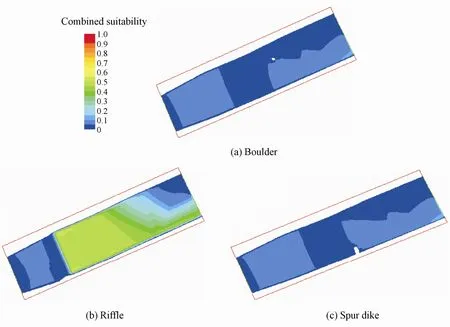
Fig. 8 Combined suitabilities after construction of different habitat structures

Fig. 9 WUA changes with different flow discharges
Fig. 8(b) shows the combined suitability after the construction of the riffle. The riffle is more effective in improving hydraulic conditions for fish than a boulder or a dike: it creates accelerated flow through the structure, causing aeration. The accelerated flow through the riffle typically creates a scour pool at the bottom of the riffle. The overall velocity gradient increases around the riffle structure. Ultimately, a riffle provides a diverse habitat and cover for an aquatic ecosystem. In the present case, the riffle significantly enhanced the habitat suitability for the target fish, especially in upstream of the riffle. The computed WUA after the construction of the riffle increased by about 131% on average for a flow discharge of 0.55 to 15 m3/s. The flow discharge for the peak WUA was about 3 m3/s. After the construction of the riffle, the peak WUA value was slightly increased. It is also interesting to note that the riffle has the effect of reducing the flow discharge for an equivalent WUA. For instance, before theconstruction of the riffle, the flow discharge for the peak WUA of about 2 000 m2was about 3 m3/s, but after the construction of the riffle, a flow discharge of only about 2 m3/s provided the same WUA as before the construction. That is, for the same WUA of 2 000 m2, about 1 m3/s of flow discharge was eliminated due to the construction of the riffle. This shows that riffles or porous weirs are effective habitat structures in urban streams that have insufficient water depths. However, in this study, the physical habitat for only one fish species was considered. Thus, for estimation of the ecological flow rate for various fish species, development of HSI for various fish species from the field monitoring is necessary.
The change of the water surface elevation caused by the habitat structures was investigated. Fig. 10 shows the water surface elevations for the design flood discharge of 280 m3/s in the downstream direction. The computed water surface elevations are the values at the center of each structure. Compared with the initial condition, the computed water surface elevations after the construction of the boulder increase locally around the boulder. Also, the spur dike increases the water surface elevation upstream of the spur dike. The maximum increment of water surface elevation is about 1.5 cm. The riffle increases the water surface elevation except around the riffle. The introduction of habitat structures into monotonoustopology urban streams can contribute to the enhancement of habitat diversity without flood control.
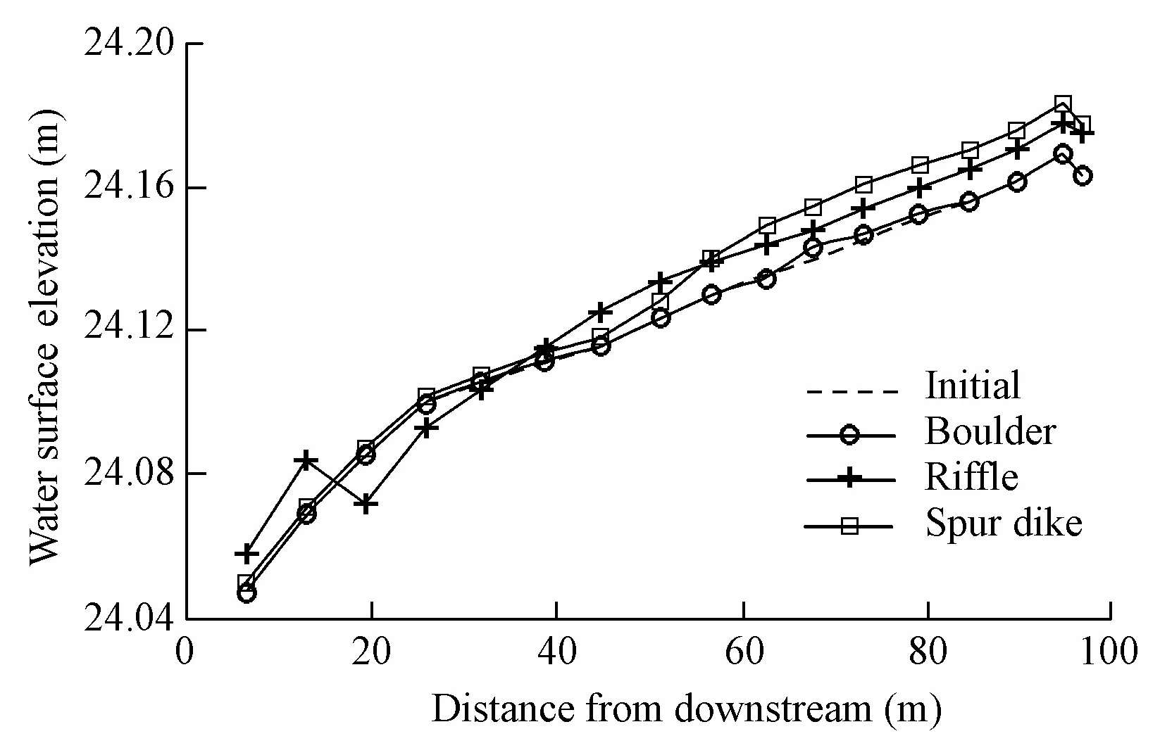
Fig. 10 Water surface elevation changes
4 Conclusions
IFIM was developed originally as a specific tool for assessment of impacts caused by flow alterations or changes in channel morphology and water quality. IFIM can be used in restoration projects to evaluate a new available habitat, either by comparing it with the original conditions or with alternative restoration scenarios. In this study, using the two-dimensional hydraulic model River2D, a physical habitat evaluation was carried out through comparison of the natural conditions with aquatic habitat improvement conditions affected by construction of habitat structures.
The habitat simulation results show that, after the construction of the boulder and spur dike, the WUA values increased by about 2% and 7%, respectively, which is not a significantimprovement. However, an approximately 131% increase in WUA was produced by construction of the riffle, thus enhancing the habitat suitability for the target fish at the site. Therefore, the riffle-type habitat enhancement structure is recommended in this case. The construction of a riffle-type habitat enhancement structure in riverbeds yields better results for urban streams that are very homogeneous and monotonous, and can increase hydraulic heterogeneity and enhance habitat diversity.
Bovee, K. D. 1982.A Guide to Stream Habitat Analysis Using the Instream Flow Incremental Methodology. Washington, D.C.: Western Energy and Land Use Team, U.S. Department of the Interior.
Bovee, K. D., Lamb, B. L., Bartholow, J. M., Stalnaker, C. B., Taylor, J., and Henriksen, J. 1998.Stream Habitat Analysis Using the Instream Flow Incremental Methodolgy. Fort Collins: USGS Biological Resources Division.
Bovee, K. D., Newcomb, T. J., and Coon, T. G. 1994.Relations Between Habitat Variability and Population Dynamics of Bass in the Huron River,Michigan. Washington, D.C.: U.S. Department of the Interior, National Biological Survey.
Crowder, D. W., and Diplas, P. 2000. Using two-dimentional hydrodynamic models at scales of ecological importance. Journal of Hydrology, 230(3-4), 172-191. [doi:10.1016/S0022-1694(00)00177-3]
Garcia, de J. D. 1995. Management of physical habitat for fish stocks. Harper, D. M., and Ferguson, A. J. D., eds.,The Ecological Basis for River Management, 363-374. Chichester: John Wiley & Sons.
Garcia, de J. D., and Gortazar, J. 2006. Evaluation of instream habitat enhancement options using fish habitat simulations: Case-studies in the river Pas (Spain).Aquatic Ecology, 41(3), 461-474. [doi:10.1007/ S10452-0006-9030-x]
Harremoes, P., Napstjert, L., Rye, C., Larsen, H. O., and Dahl, A. 1996. Impact of rain runoff on oxygen in an urban river.Water Science and Technology, 34(12), 41-48. [doi:10.1016/S0273-1223(96)00852-9]
Im, D., Kang, H., Kim, K. H., and Choi, S. U. 2011. Changes of river morphology and physical fish habitat following weir removal.Ecological Engineering, 37(6), 883-892. [doi:10.1016/j.ecoleng.2011.01.005]
Jowett, I. G. 1992. Models of the abundance of large brown trout in New Zealand rivers.North American Journal of Fisheries Management, 12(3), 417-432. [doi:10.1577/1548-8675(1992)]
Kim, K. H. 1999.Evaluation of Habitat Conditions and Estimation of Optimum Flow for the Freshwater Fish. Ph. D. Dissertation. Seoul: Yonsei University. (in Korean)
Konrad, C. P. 2009. Simulating the recovery of suspended sediment transport and river-bed stability in response to dam removal on the Elwha River, Washington.Ecological Engineering, 35(7), 1104-1115. [doi:10.1016/j.ecoleng.2009.03.18]
Lee, J. H., Kil, J. T., and Jeong, S. 2010. Evaluation of physical fish habitat quality enhancement designs in urban streams using a 2D hydrodynamic model.Ecological Engineering, 36(10), 1251-1259. [doi:10. 1016/j.ecoleng.2010.05.004]
Mouton, A. M., Schneider, M., Depestele, J., Goethals, P. L. M., and Pauw, N. D. 2007. Fish habitat modelling as a tool for river management.Ecological Engineering, 29(3), 305-315. [doi:10.1016/j.ecoleng. 2006.11.002]
Nagaya, T., Shiraishi, Y., Onitsuka, K., Higashino, M., Takami, T., Otsuka, N., Akiyama, J., and Ozeki, H. 2008. Evaluation of suitable hydraulic conditions for spawning of ayu with horizontal 2D numerical simulation and PHABSIM.Ecological Modeling, 215(1-3), 133-143. [doi:10.1016/j.ecolmodel. 2008.02.043]
Nehring, R. B., and Anderson, R. M. 1993. Determination of population-limiting critical salmonid habitats in Colorado streams using IFIM/PHABSIM.Rivers, 4(1), 1-19.
Nolan, P. A., and Guthrie, N. 1998. River rehabilitation in an urban environment: Examples from the Mersey Basin, North West England.Aquatic Conservation: Marine and Freshwater Ecosystems, 8(5), 685-700.[doi:10.1002/(SICI)1099-0755(199809/10)8:5<685::AID-AQC308>3.0.CO;2-9]
Railsback, S. F., Blackett, R. F., and Pottinger, N. D. 1993. Evaluation of the fisheries impact assessment and monitoring program for the Terror Lake hydroelectric project.Rivers, 4(4), 312-327.
Reice, S. R., Wissmar, R. C., and Naiman, R. J. 1990. Disturbance regimes, resilience, and recovery of animal communities and habitats in lotic ecosystems.Environmental Management, 14(5), 647-659. [doi:10. 1007/BF02394715]
Steffler, P., and Blackburn, J. 2002.River2D, Two-dimensional Depth Averaged Model of River Hydrodynamics and Fish Habitat, Introduction to Depth Averaged Modeling and User’s Manual. Edmonton: University of Alberta.
Sung, Y. D., Park, B. J., Joo, G. J., and Jung, K. S. 2005. The estimation of ecological flow recommendations for fish habitat.Journal of Korea Water Resources Association, 38(7), 545-554. (in Korean)
Waddle, T. J. 2001. PHABSIM for Windows: User’s Manual and Exercises. Fort Collins: U.S. Geological Survey.
White, R. J., and Brynildson, O. M. 1967.Guidelines for Management of Trout Stream Habitat in Wisconsin. Madison: Department of Natural Resources.
*Corresponding author (e-mail:hskang@kei.re.kr)
Received Feb. 24, 2011; accepted Sep. 9, 2011
杂志排行
Water Science and Engineering的其它文章
- Experimental study on total dissolved gas supersaturation in water
- Hydrodynamic effects of reconnecting lake group with Yangtze River in China
- Sediment transport following water transfer from Yangtze River to Taihu Basin
- Research on shape optimization of CSG dams
- Analysis of black water aggregation in Taihu Lake
- Large eddy simulation of water flow over series of dunes
