Health Assessment of Typical Reservoirs in Eastern Jilin: A Case Study of Niligou Reservoir
2024-02-26MeihuaHUANGJingWANGYinglinXIEChunshengWEIXinTIANLunwenWANG
Meihua HUANG, Jing WANG, Yinglin XIE, Chunsheng WEI, Xin TIAN, Lunwen WANG
1. Jilin Provincial Bureau of Hydrology and Water Resources (Jilin Provincial Water Environment Monitoring Center), Changchun 130022, China; 2. Changchun Xinlicheng Reservoir Management Center, Changchun 130000, China
Abstract Niligou Reservoir, a typical reservoir in the eastern region of Jilin Province, is subordinate to Niligou River, which is located in the Changbai Mountains in eastern Jilin, with abundant plant and animal resources and well protected biodiversity in the basin, but there are also some related problems such as fragile ecosystem of forest wetland. This paper carried out a health assessment of Niligou River, including water quality monitoring, aquatic organism monitoring, and riparian zone investigation. According to the requirements of the Technical Guidelines for River and Lake Health Assessment, 13 assessment indexes were selected to build a river and lake health assessment index system. By sorting and analyzing the monitoring and investigation data, we got a clear picture of the ecological environment status and existing problems of Niligou Reservoir. Based on the actual situation of Niligou River, we evaluated the hydrologic integrity, chemical integrity, morphological and structural integrity, biological integrity and sustainability of social service function, and put forward corresponding countermeasures according to the results, in order to provide a technical support for the health treatment of rivers and lakes in Jilin Province.
Key words Eastern Jilin, Niligou Reservoir, Health assessment
1 Overview of the study area
1.1OverviewofnaturalgeographyofNiligouRiverNiligou River is located in Changbai Korean Autonomous County, the southeast of Jilin Province, at the southern foot of Changbai Mountain and on the right bank of the upper reaches of the Yalu River (Fig.1). Changbai County boasts numerous rivers, lakes and reservoirs, and abundant water resources[1]. Niligou River is a first-level tributary of the left bank of Badaogou River, with a drainage area of 48.5 km2, a length of 15.9 km from the source to the estuary, and an annual average runoff of about 17 million m3. The river channel varies in width, and the river bed is mostly composed of gravel. Due to dense vegetation around the river bank, pollution-free water body and rich fish resources, Niligou River attracts the birds and beasts that feed on fish and shrimp to gather here, becoming the ideal place and home for them to feed, stay, nest (hole), live and multiply. Niligou Reservoir is built on Niligou River, with a reservoir capacity of 5.59 million m3. Niligou Reservoir, 41.031 38°-41.034 206° N, 127.038 170 5°-127.043 441° E, has a control area above dam site of 39 km2, a river length of 12.1 km, and a total reservoir capacity of 7.8 million m3.
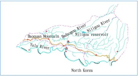
Fig.1 Schematic diagram of the location of Niligou River
Niligou River is located on the south slope of Changbai Mountain range. Affected by Himalayan orogeny from the end of Tertiary period to the beginning of Quaternary period, large amounts of basalt erupted along with the fault, constituting a large area of lava platform, which was a volcanic accumulation terrain with an elevation of 976-1 100 m. According to its genetic morphology, the landform consists of flood plain, river valley slope, platform slope, lava platform, middle mountainous slope and middle mountain. The strata in this area belong to North China—Yanshan region, and are mainly Cenozoic and Mesozoic, with not developed regional structure and no large fault zone through the area recently, being a relatively stable area. This area is a moderate and weak earthquake area in Northeast China, with low seismicity in modern times.
Niligou River belongs to the Yalu River system. Yalu River is the boundary river between China and North Korea, and is also the main water system of Changbai County, with more than 20 rivers flowing into the Yalu River in turn. Niligou River is a first-level tributary of the upper left bank of Badaogou River, with a drainage area of 48.5 km2and a channel length of 15.8 km. Niligou reservoir in the upper reaches of the river has a storage capacity of 5.59 million m3. The rivers in this area are mainly replenished by atmospheric precipitation, with surface runoff receiving groundwater replenishment in dry season, and river water appropriately replenishing groundwater in wet season. The groundwater is mainly in shallow circulation, with deep circulation in the karst area. The groundwater in Niligou River is mainly composed of pore water of loose rock, karst fissure water of carbonate rock, pore fissure water of clastic rock and bedrock fissure water.
Niligou River, located in middle latitude, belongs to the sub-temperate continental monsoon climate, which is cold in winter and warm in summer, with four distinct seasons. In spring, there is uneven cold and warm temperature, warm and dry air, decreasing precipitation and mostly westerly gale; in summer, there is concentrated precipitation, many warm and rainy days but less hot days; in autumn, the temperature drops day by day, accompanied by constant invasion of cold air and emergence of frost; in winter, the weather is severely cold, with a duration of more than 5 months.
Due to the influence of natural factors such as terrain, climate, hydrology, vegetation, parent material and human factors on soil formation conditions, there are five types of soil along the bank of Niligou River, namely gray brown soil, albic soil, meadow soil, swampy soil, peat soil. Gray brown soil and albic soil are mostly in complex distribution, with albic soil mainly distributed on the flat lava platform above the elevation of 970 m, and there are sporadic meadow soil, swampy soil and peat soil on both sides of the river and in the low lying areas of the platform.
1.2SocialandeconomicsituationoftheareawhereNiligouRiverislocatedAfter revision of economic census data, Changbai County achieved a regional GDP of 339.554 million yuan in 2019, with a comparable growth of 0.7%. The primary industry achieved an added value of 478.43 million yuan, with an increase of 2.2%; the secondary industry achieved an added value of 773.63 million yuan, with an increase of 18.6%; and the tertiary industry reached an added value of 2 143.48 million yuan, with a negative growth of 3.4%. The three industrial structures were adjusted to a ratio of 14.1:22.8:63.1. The per capita GDP of Changbai County reached 43 894 yuan, with an increase of 2.2%. In 2019, the total output value of agriculture, forestry, animal husbandry and fishery in the county reached 825.07 million yuan, with a comparable growth of 1.9%, while the added value reached 484.28 million yuan, with an increase of 2.1%.
Niligou River is an important river in Changbai County. Since the 1980s, due to the large-scale agricultural development around Niligou River by the residents of the surrounding villages, some riparian zones and wetlands had been reclaimed into farmland, resulting in the deterioration of the ecological environment around the river bank. In recent years, with the popularity of Two Mountains Theory, the overdevelopment of Niligou River has been effectively curbed, and ecological restoration projects have been carried out in the Niligou River basin, so that the natural environment and resource conditions of riverine wetlands have been improved to a certain extent. To have a deeper sight into the problems existing in the ecological protection of Niligou River, we can not have a complete understanding of the health status of river, lake and reservoir ecosystems relying only on a single water environment monitoring means and evaluation method, as well as a water quality assessment technology system based on single physicochemical index. Therefore, based on the actual situation of Niligou River, this paper evaluated the health status of Niligou River basin from five aspects, including hydrologic integrity, chemical integrity, morphological and structural integrity, biological integrity, and sustainability of social service function, and proposed corresponding countermeasures according to the research results, in order to provide a technical reference for water resources management and ecological restoration in Niligou River basin.
2 Ecological and environmental health status of Niligou Reservoir
2.1Waterqualityandwaterecologymonitoring
2.1.1Water quality monitoring. According to the flow characteristics of the monitoring section, three monitoring points were set up in Niligou River with a depth of 4 times the width of the river for the river segment with a depth of less than 5 m. As Niligou Reservoir is a narrow mountain reservoir, three monitoring points were set up from the beginning to the end of the reservoir according to the requirements of river subsection (Table 1). The layout of sections followed the basic principles of monitoring section layout, which can reflect the water environment quality of Niligou River on a macro level. The layout of the monitoring sections of Niligou River also avoided dead water area, backwater area and sewage outlet, and sampling points were set in the straight river section convenient for sampling, with stable river bed, smooth water flow, wide water surface, no rapids or shoal. The six sections included background section, contrast section, control section and estuary section.
The monitoring project selected 22 monitoring indicators included in the routine detection of surface water, including pH value, dissolved oxygen, permanganate index, COD, BOD5, ammonia nitrogen, total phosphorus, copper, zinc, fluoride, selenium, arsenic, mercury, cadmium, hexavalent chromium, lead, cyanide, volatile phenols, petroleum, anionic surfactants, sulfides, and fecal coliform.
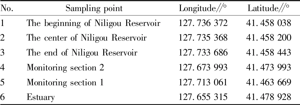
Table 1 Latitude and longitude of sampling points
2.1.2Water ecology monitoring. The investigation team conducted the sampling and monitoring of phytoplankton and benthos, as well as a survey of fish stocks in Niligou River in September 2023.
According to the objectives, contents and requirements of the project and the present situation of Niligou River basin, three biological monitoring points were set up in Niligou Reservoir to monitor phytoplankton qualitatively and quantitatively.
Qualitative samples were hauled with plankton net No.25. Quantitative samples were 2 L of water collected at about 0.5 m below the water surface with a 5 L water sampler, fixed with Lugo’s solution on site, and then left undisturbed for 48 h when brought back to the laboratory. Finally, the solution was concentrated to 30 mL for biological classification and counting under the Leica DM 750 optical microscope.
The investigation and assessment was limited to Niligou River. Samples were collected and tested in accordance with theTechnicalGuidelinesforRiverandLakeHealthAssessment(SL/T 793-2020), theCodeforReservoirFisheryResourcesInvestigation(SL 167-96), theManualforFisheryNaturalResourcesInvestigationinInlandWaters, and theTechnicalRegulationsforPhytoplanktonMonitoringinInlandWaters(SL 733-2016). Analogy analysis, conventional analysis and ecological mechanism analysis were employed for analysis and evaluation.
2.2Surveyofhydrology,waterresourcesandmorphologicalstructuralintegrity
2.2.1Survey of hydrology and water resources. There is no hydrographic station in Niligou River, so the relevant hydrological and water resources data can only be derived from local hydrological monitoring agencies and collected from existing relevant plans, reports and literature.
Niligou River is a second-level tributary of Badaogou River, and there is no hydrological observation station in its basin. When the Northeast Survey, Design and Research Institute of the Ministry of Water Resources designed Baoquan third-level station, temporary hydrological stations were set up at several dam sites for data observation in 1974-1978. In the adjacent basin Sandaogou River, there was a Sandaogoumen hydrological station established in January 1957, belonging to a national basic station. This time, Sandaogoumen hydrology station was selected as the reference station. Referring to the data of Sandaogoumen hydrology station, the water flow of Niligou River was analyzed and calculated by using hydrological area analogy method, and the discharged ecological flow from reservoirs was calculated by referring to the monitoring data of reservoir management bureau.
2.2.2Inspection of morphological integrity. Niligou River and its surrounding riparian zone were surveyed in August 2023, and factors such as land use type, vegetation cover and human disturbance in the river and riparian zone were comprehensively considered. The specific investigation points are shown in Table 2.
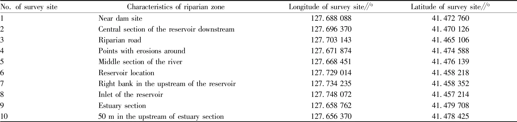
Table 2 Location of vegetation cover survey sites in the riparian zone of Niligou River
The survey was conducted in accordance with theTechnicalGuidelinesforRiverandLakeHealthAssessment(SL/T 793-2020), including stability of riparian zone, vegetation coverage of riparian zone, artificial disturbance,etc.
3 Establishment of Niligou Reservoir Index system
The establishment of an evaluation index system can monitor and evaluate the evaluation object scientifically, and more comprehensively reflect the change trend of the health status of the evaluation object over time, especially evaluate the effectiveness of management behavior through comparison. The research evaluation system mainly comprises three levels, namely target level, criterion level and indicator level. The target layer refers to the health status of Niligou River; the criteria layer includes hydrological integrity, morphological and structural integrity, chemical integrity, biological integrity and service function integrity; the indicator layer includes national basic indicators and indicators increased according to basin characteristics (Table 3).
4 Health assessment of Niligou Reservoir
4.1AssessmentofwaterresourcesintegrityUtilization rate of water resources development refers to the ratio of water consumption in a basin or region to the total water resources. According to investigation, the area around the Niligou River basin is sparsely populated, and there is no quantitative data statistics in this region. Therefore, the utilization rate of water resources development in Changbai County in 2022 was used to characterize the utilization rate of water resources development in this region[2].
Referring to theNoticeofIssuingtheGuidingOpinionsonEcologicalIndexSystemandApplicationofWaterEngineeringPlanningandDesignby the General Institute of Water Conservancy and Hydropower Planning and Design of the Ministry of Water Resources (SZHY [2010] 248), the ecological basic flow should be determined separately in non-flood season and flood season in the northern region. Considering the climatic conditions and downstream ecological water requirements of Niligou River, the minimum ecological flow from April to September is considered as 20% of the average annual runoff, and those in other months is considered as 10% of the average annual runoff.
According to theTechnicalGuidelinesforRiverandLakeHealthAssessment, the hydrological integrity of Niligou Reservoir was scored 97.4 points.
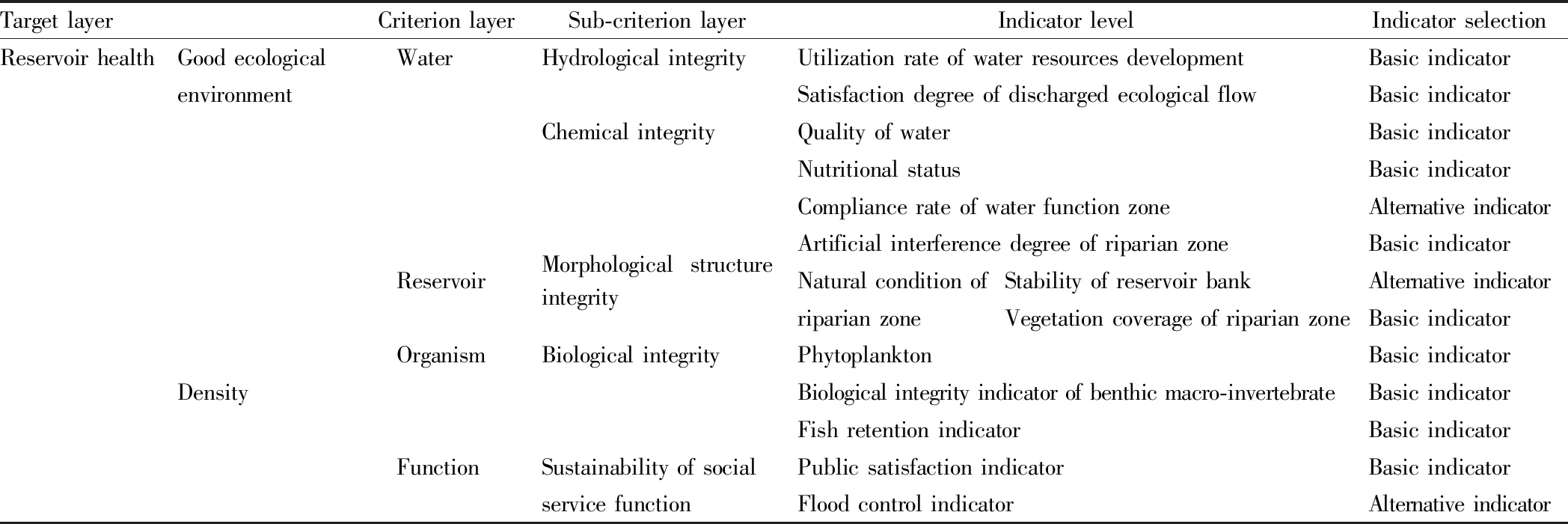
Table 3 Health evaluation index system of Niligou Reservoir
4.2AssessmentofmorphologicalandstructuralintegrityOn the basis of the evaluation grading criteria for bank erosion, the survey data were assigned scores, including 85 points for slope inclination angle, 50 points for vegetation coverage, 85 points for bank height, 90 points for substrate, 90 points for erosion status, and 80 points for overall stability assessment of reservoir bank.
The reservoir bank vegetation coverage index of Niligou River was evaluated and assigned following the direct evaluation criteria of reservoir bank, and the vegetation coverage of Niligou reservoir was assigned 61.5 points.
According to the investigation of artificial interference at each monitoring point, the artificial interference along the embankment zone of Niligou reservoir was assigned 95 points.
The longitudinal river connectivity index, riparian zone stability, bank artificial interference status and vegetation coverage rate of Niligou River and Niligou reservoir were weighted to obtain the score of morphological structure criterion layer, and the morphological structure criterion layer of Niligou reservoir was scored 80.5 points.
4.3AssessmentofchemicalintegrityThe total phosphorus, total nitrogen, chlorophyll, permanganate index and transparency in the data of Niligou Reservoir in June and September 2023 were selected for evaluation, and the trophic state index value of the water body of Niligou Reservoir was calculated according to theTechnicalRegulationsofSurfaceWaterResourceQualityEvaluation(SL395-2007). The eutrophication status was calculated according to the eutrophication evaluation criteria of lakes and reservoirs. The trophic state index of Niligou reservoir was calculated to be 55.8, which was in the state of mild eutrophication, and thus the index was assigned 50 points.
According to theSurfaceWaterEnvironmentalQualityStandard(GB3838-2002), 3 categories of water quality were evaluated, and the water quality categories of the evaluation section were determined by the worst indicator. It can be seen that the water quality of Niligou Reservoir was classified as class II.
Chemical integrity evaluation includes 3 indexes, and the minimum score of them is selected as the chemical integrity score. The chemical integrity of Niligou reservoir was assigned 50 points.
4.4AssessmentofecologicalintegrityA total of 33 species of fish belonging to 12 families, 6 orders were collected from Niligou River and Niligou Reservoir. During the investigation, visit and monitoring in 2022, a total of 23 species of fish from 10 families, 5 orders were collected. After expert consultation and confirmation, it was calculated by the formula that the fish retention index was 92%, and the fish retention index was assigned 100 points.
According to the phytoplankton sampling and monitoring data of Niligou reservoir in June and September, the average annual phytoplankton density of Niligou Reservoir was 1.76×10⁶individual/L, which was assigned by direct evaluation method. According to theTechnicalGuidelinesforRiverandLakeHealthAssessment(SL/T 793-2020), the number of phytoplankton in Niligou Reservoir was directly evaluated and the density of phytoplankton was assigned 70 points.
In August 2023, the project team conducted a qualitative and quantitative investigation on the status of benthic macro-invertebrate in Niligou River and Niligou Reservoir. The entrance section of Niligou Reservoir was determined as the reference point, with the other sections as the damaged points. According to the local conditions, samples were collected once at each of the 3 damaged sites. After sorting, a total of 12 species of benthic animals were obtained, including mosquito larvae and neritidae larvae, belonging to Oligochaeta, Gastropoda, Lamellibranchia, Crustacea and Insecta. Since there is no historical monitoring data of Niligou River and Badaogou River, the historical data refer to the Yalu River.
Through the redundancy analysis of alternative parameters, the parameters that can reflect the species diversity, abundance, community structure composition, pollution tolerance, functional feeding groups and life forms of benthic macro-invertebrate were screened. The BIBI index system consisting of total taxa number, Ephemeroptera taxa number, percentage of pollute-tolerant taxa, and BMWP index of benthic macro-invertebrate intolerant group was determined, and the biological integrity scored 70 points.
4.5AssessmentofsocialfunctionsustainabilityConsidering the flood control and other service functions of the Reservoir, we distributed 100 public satisfaction questionnaires to the public, and recovered 98. The average scoring was 80.
5 Health assessment of Niligou Reservoir
Through the health assessment of ecological condition and service function of Niligou Reservoir, Niligou Reservoir was classified into the grade of very healthy, with 97.4 points for hydrological integrity, 50 points for chemical integrity, 80.5 points for morphological and structural integrity, 70 points for biological integrity, and 80 points for sustainability of social service function. After weighted calculation, the health assessment of Niligou Reservoir was assigned 75.5 points (Table 4). Hence, Niligou River was in a healthy state.

Table 4 Health scoring of Niligou Reservoir
6 Suggestions
6.1EnsuringthedischargedecologicalflowofReservoirandreducingtheimpactofhumanactivitiesonrunoffThe upstream of Niligou River is an important forest and swamp ecosystem and water collection area, and also an important guarantee of water resources security in Niligou River and Badaogou River basin. It is also an important habitat for rare and endangered wildlife resources such asMergussquamatus. Niligou River Basin, with crisscrossing river network and good habitat conditions, is a good wetland community and habitat for rare wild animals and plants, thus becoming a key protection area in the Yalu River Basin. Niligou River mainly aims to protect the health of water environment, so it is advocated to reduce manual intervention, thus realizing natural succession of river ecosystems by self-metabolism.
6.2EffectivemeasuresshouldbetakentocontrolwaterqualityinNiligouReservoirScientific and effective protection measures should be taken to further improve the ecological structure of Niligou River and Niligou Reservoir, and improve the heterogeneity and stability of habitat. The treatment of agricultural water pollution in Niligou River should be strengthened to intensify pollution control and management in tourist areas. Water resources in the river basin must be allocated scientifically, ensuring the ecological water demand of Reservoir wetland through ecological replenishment.
6.3Adjustingtheindustrialstructureandrationallydevelopingeco-tourismThe conservation of fish resources and the protection and restoration of their habitats in Niligou River can be realized through the rational planning of fishery production and tourism industry.
杂志排行

Asian Agricultural Research的其它文章
- Practice and Thinking of Agricultural Science and Technology Experts Serving the Grassroots to Promote Rural Revitalization
- Technique of Earthworms Restoring Soil in Greenhouse Cultivation
- Research Progress on Nutritional Requirements of Carp
- Discussion on Land Use Mode Reform in Coal Opencast Mining
- Guarantee Strategy for the Safety of Agricultural Industry in Hunan Province
- Study on Solid Fermentation and Antioxidant Function of Natto