Influence of water conservancy project on runoff in the source region of the Yellow River and wetland changes in the Lakeside Zone, China
2024-01-08MingnanYangLiangZhuJingtaoLiuYuxiZhangBingZhou
Ming-nan Yang, Liang Zhu, Jing-tao Liu, Yu-xi Zhang,3, Bing Zhou
1 Institute of Hydrogeology and Environmental Geology, Chinese Academy of Geological Sciences, Shijiazhuang 050061, China.2 Key Laboratory of Groundwater Sciences and Engineering, Ministry of Natural Resources, Shijiazhuang 050061, China.3 Fujian Provincial Key Laboratory of Water Cycling and Eco-Geological Processes, Xiamen 361021, Fujian Province, China.
Abstract: The source area of the Yellow River (SAYR), located above the Huangheyan hydrological station, is important for ecological preservation and water source conservation in the Yellow River Basin.In this area, the impact of water conservation projects on the hydrology and the ecological environment is pivotal in protecting water resources and alpine vegetation ecosystems.This study investigates the impact of the Yellow River Source Hydropower Station on the runoff and ecological evolution of the SAYR, along with the underlying mechanism, using extensive datasets encompassing long-term meteorological, hydrological and remote sensing data from various time periods.Results show that, over the long term, precipitation is the primary factor driving runoff variations in the SAYR.Nevertheless, from 1990 to 2020, there is a notably inconsistent relationship between precipitation and runoff.After the completion of the Yellow River Source Hydropower Station in 2001, the water level of Eling Lake experienced and elevation of 2-3 m, leading to a gradual recovery of runoff.In addition, the basin's water balance shifted from a negative to a positive equilibrium, oscillating with changes in lake water levels.Consequently, the overflow zone of the Tangchama alluvial-proluvial fan in the upper reaches of the lakeshore shifted by 500 m, and marsh wetlands expanded by 20.78 km2.The increased storage of lakes and groundwater in the SAYR is the key controlling factor for the runoff recovery, changes in the basin's water balance, and enhancements in lakeshore vegetation ecology.Under the geological background of the Qinghai-Tibet Plateau's upliftment and intensified upstream river erosion, the basin experienced a substantial water imbalance due to declining discharge base levels, which is the most critical factor behind runoff attenuation in the SAYR towards the end of the 20th century.The construction of the hydropower station objectively raised the drainage base level of the basin, thereby positively contributing to the preservation of water balance, runoff stability, and the enhancement of swamps and wetlands along the lakeshore.
Keywords: Groundwater; Discharge baseline; Wetland ecology; Runoff; Climate change Received: 20 Dec 2022/ Accepted: 12 Sep 2023/ Published: 10 Dec 2023
Introduction
The source area of the Yellow River (SAYR),located in the hinterland of the Qinghai-Tibet Plateau, is characterised by a fragile ecological environment extremely sensitive to changes in its hydrological conditions.Over recent decades,SAYR has experienced significant changes in its water balance and ecological hydrological processes, attributed to the dual forces of climate change and human activities (Xu, 2015; Li et al.2021; Zhu et al.2022a).Towards the end of the 20thcentury, SAYR faced critical environmental and geological challenges, including runoff attenuation, interruption in river flow, and wetland degradation.These issues commanded widespread attention from the entire society (Zhang et al.2003; Chen and Liu, 2009; Tian et al.2015; Wang et al.2020).In the context of intensified climate change and the national strategic emphasis on ecological preservation and high-quality development in the Yellow River Basin, the study of water balance evolution and its resultant hydrological and ecological impacts on the SAYR, often referred to as the "water tower", has become a hot topic within the field of water resource research.
Within the hydrological cycle of a watershed,critical elements such as precipitation, runoff and evapotranspiration, naturally maintain a dynamic equilibrium.Around 60% to 70% of the precipitation dissipated in the form of evapotranspiration(Yang et al.2022).Significant changes in any of these water cycle elements trigger a transition in the water balance, subsequently impacting the ecological and hydrological processes of the watershed (Huang et al.2020; Tesfaldet et al.2020; Zhu et al.2021; Liu et al.2023).In the natural, onedimensional and static water cycle mode, the discharge and storage conditions of water resources tend to remain stable.This stability arises from the inherent characteristics of the surface and the consistent regional hydrogeological conditions(Kustu et al.2010; Wu et al.2020; Zhu et al.2022b).However, the SAYR is located on the northeastern edge of the permafrost region of the Qinghai-Tibet Plateau, which is highly sensitive to climate changes.As temperature rises, the upper permafrost interface recedes at an average rate of 3-5 cm/year, with seasonal permafrost expanding its reach (Jin et al.2009; Cao et al.2021).Permafrost, acting as a stable impermeable layer in the region, influences hydrogeological conditions.It augments soil and groundwater storage capacity,transforming solid water into liquid water and integrating it into hydrological cycles (Yang et al.2019; Song et al.2020; Cao et al.2021).Runoff analysis indicates that melted water from frozen soil accounts for approximately 14.4% of the runoff in the SAYR, and this proportion continues to rise with intensified frozen soil degradation (Ma et al.2019).Geological processes also exert a significant impact on the hydrological processes in the SAYR.Throughout different phases of the Qinghai-Tibet Plateau's uplift, the hydrological system underwent significant alterations.In the late Pleistocene, the Yellow River redirected its course by crossing the Bayankala Mountains and integrating the Yangtze River water system.Presently, the modern Qinghai-Tibet Plateau rises at a rate of 5.8 mm/a (Cheng et al.2007; Wu et al.2019).This uplift not only alters the terrain's morphology but also enhances the erosion dynamics of the regional hydrological network, with more intensified erosion closer to the source area(Jia et al.2017).Photoluminescence dating demonstrates that the main stream of the Yellow River in the Tongde Basin experiences an average river cutting rate of 0.78 m/1000 a, with the maximum rate of 0.24 m/a observed in Ruoergai Wetland (Li et al.2014).In the SAYR, river erosion leads to a decline in the discharge base level and exacerbates groundwater discharge, which has become a prominent feature of hydrological system transformations (Wan et al.2019; Zhu et al.2021).On a slope scale, monitoring and simulation studies reveal that when water erosion penetrates the surface peat layer, groundwater discharge capacity can surge to 2.52 times the original capacity (Li et al.2018).Additionally, isotope analysis and basic flow segmentation results indicate that groundwater, encompassing water above and below the frozen layer and groundwater in the melting zone,contributes to roughly 60% of the runoff in the SAYR, making it the primary runoff source (Yi et al.2018; Zhu et al.2022a).Therefore, the impact of changes in groundwater discharge intensity on watershed water balance and ecological hydrological processes should not be underestimated.However, current research primarily focuses on factors such as precipitation, evapotranspiration and permafrost degradation (Dai et al.2018; Mo et al.2022; Cao et al.2021; Li et al.2021).The study of hydrological and ecological consequences stemming from shifts in groundwater discharge remains unexplored, and differing interpretations of groundwater across disciplines contribute to a bias regarding the importance of groundwater in the evolution of hydrological and ecological environments in river basins.For instance, Yang (2019) classified water discharged as springs following infiltration during the rainy season as precipitation recharge, leading to a notable reduction in the proportion of groundwater in the hydrological environment.
The present study combines extensive, longterm datasets spanning from 1960 to 2020, encompassing precipitation, runoff, and remote sensing data.A comparehensive analysis is undertaken to investigate the evolving trend of water balance in the SAYR.The control factors are revealed by examining how shifts in the groundwater discharge baseline influence the water balance of the river basin.In addition, the mechanisms behind the impact of the construction and operation of the Yellow River Source Hydropower Station on the basin's water balance, the evolution of runoff pattern, and transformations occurring within the lakeside swamp wetlands are explored.Based on these insights, recommendations are proposed to maintain the stability of the discharge baseline after the demolition of the hydropower station.The findings from this research present great significance for the water conservation function and wetland ecosystem protection of the Yellow River source area under climate change.
1 Study area
Upstream of Maduo, the Yellow River is referred to as the source region, extending over a length of 285.5 km and encompassing a drainage basin area of 20,930 km2.Notably, Zhaling and Eling Lakes function as reservoirs for the Yellow River, with a combined storage capacity of approximately 153 ×108m3.This capacity is 22.5 times greater than the average annual runoff of the Yellow River measured at the hydrological station.Key tributaries,including Kariqu, Duoqu, Lenaqu and Requ, are predominantly distributed along the south bank of the main river channel.Under the interaction between river water and groundwater, the lowlying swamps in the front edge of the mountain alluvial fan and the alluvial lake plain constitute the exceptionally diverse ecological landscape.The average elevation in the SAYR exceeds 4,200 m,with over 80% of the terrain being covered by permafrost.This region falls within the plateau continental semi-arid and high-cold climate zone,characterised by an average annual precipitation of 326.4 mm and an average annual evaporation of 797.7 mm (E601).The central part comprises the basins of Zhaling and Eling Lakes, as well as the Yellow River's expansive alluvial plain, which features an open and stretching topography.The north and south sides of the region are bedrock mountainous areas, while the intermountain basins are developed with strong retrogressive erosion of gullies and valleys.In the mountainous areas,atmospheric precipitation serves as a pivotal source of groundwater.This groundwater undergoes multiple interactions with surface water during the runoff process, eventually emerging from mountain passes as surface runoff.Subsequently, this outflow re-infiltrates and replenishes groundwater in the alluvial plain in front of the mountain,converging with Zhaling and Eling Lakes and the Yellow River Valley, and ultimately concentrates and discharges through surface runoff and evaporation (Fig.1).
In the SAYR, the population is sparse, and water resource development and utilisation have historically been minimal.To address the electricity needs of Maduo County, the government initiated the construction of the Yellow River Source Hydropower Station in 2001, positioned on the main river channel, approximately 17 km downstream from the mouth of Eling Lake.However, as Qinghai Province progressively integrated its power grid systems, the hydropower station's role in electricity supply diminished.Consequently, in 2017,the decision was made to dismantle the generator unit, retaining only the spillway as a means to discharge the reservoir water.By 2022, Qinghai Province completely demolished the dam of the Yellow River Source Hydropower Station and restored the river connectivity and natural channel morphology within the SAYR.
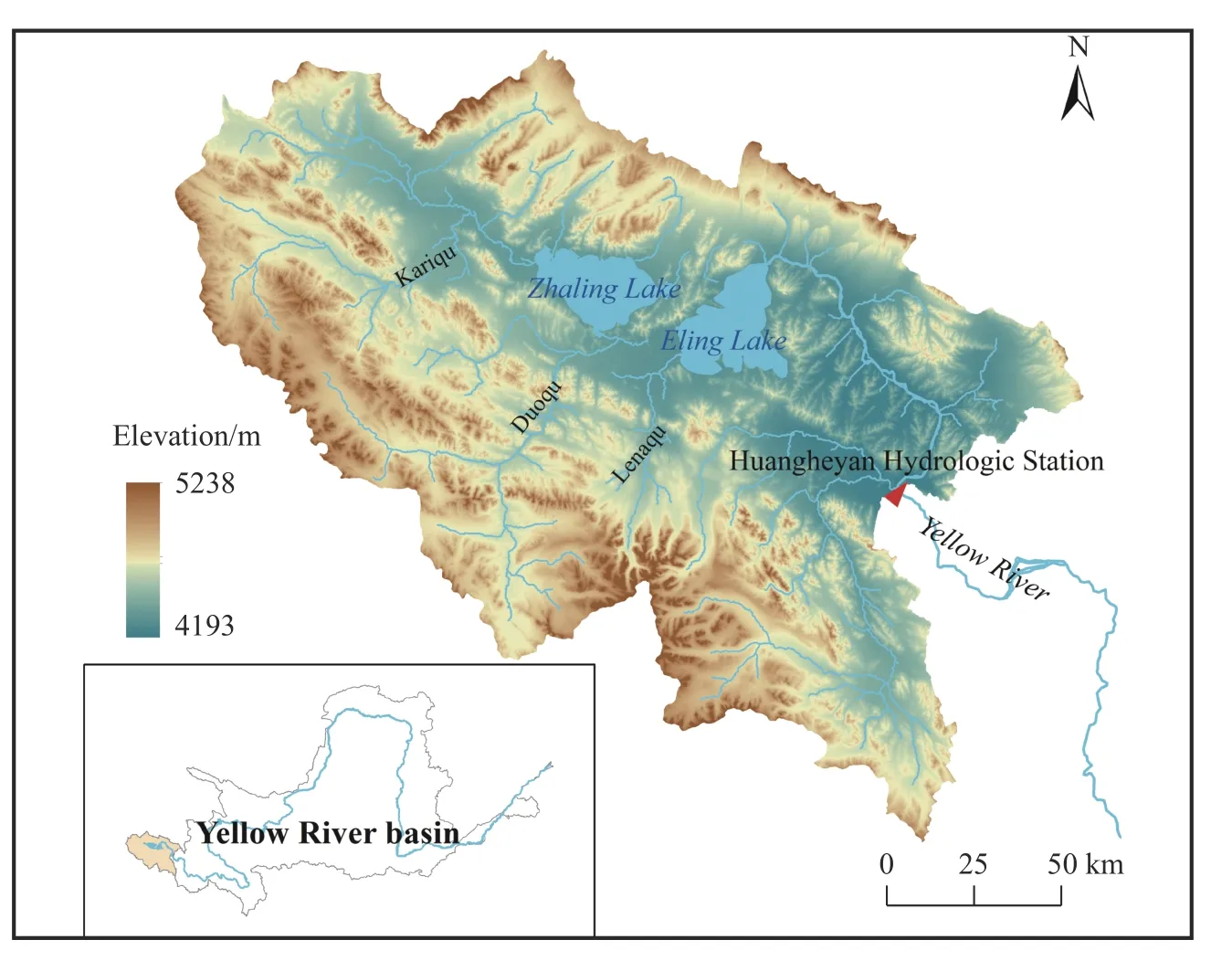
Fig.1 Study area
2 Data and methods
2.1 Data
This study analyses a dataset comprising average annual evaporation and monthly precipitation records from Maduo Meteorological Station spanning the period of 1960 to 2020.Additionally, it includes monthly runoff data from hydrological stations situated along the Yellow River, water level elevations recorded for Lake Eling from 1978 to 2020, and a collection of multi-period remote sensing images.The precipitation and evaporation data are sourced from the China Meteorological Data Network (http://data.cma.cn/).The runoff and lake water levels have been gathered through hydrological stations along the Yellow River, as well as the water and cultural monitoring stations of Eling Lake.The remote sensing images utilized in this study are from Landsat TM and OLI satellites with a spatial resolution of 30 m.
2.2 Water balance Equation
In the SAYR, significant permafrost coverage is evident, yet no glaciers are observed in this region.Notably, permafrost in this area exhibits a trend of degradation, primarily influenced by ongoing climate change.In light of the challenges associated with accurately quantifying the release of permafrost accross the entire basin, it is no longer calculated separately.Instead, it is now included in the scope of water storage variables.Therefore, the water balance equation in the SAYR is expressed as:
Where:Pis the basin precipitation (mm);Eis the evapotranspiration of the watershed (mm);Ris the runoff rate (mm);ΔWis the water storage variable of the basin (mm).The evapotranspiration of the watershed is based on the conversion results of the evaporation dish monitoring data at the Maduo Meteorological Station, with reference to previous conversion coefficients of 0.22 in the 1960s and 1980s and 0.25 after the 1990s (Wan et al.2003).
3 Results and discussion
3.1 Evolution trend of water balance
The analysis of water balance evolution in the SAYR is based on the long-term datasets encompassing precipitation, runoff, and evapotranspiration.Employing Equation (1), the basin's water storage variables from 1960 to 2020 are calculated using the anomaly method to analyse the cumulative anomaly trend ofΔWchanges (Fig.2).The results indicate that the evolution of water balance can be divided into two stages.During the period of 1960-2000, a cumulative deficit was evident,characterized by negativeΔWanomalies and a fluctuating decreasing trend.This observation implies that, for the majority of these years, the water balance within the basin was in a stage of negative equilibrium, with water resource concentrating, especially after the mid-1970s.In the case of long-term alternating surpluses and deficits, the"water tower" of the Yellow River source consistently experienced a loss of water, exacerbating the severity of water deficit in the basin.Conversely,the period spanning 2000-2020 marked a phase of gradual recovery.Most years exhibited positiveΔWanomalies, with a fluctuating upward trend.During this phase, the water balance within the basin reached a state of positive equilibrium, where the input components of the watershed water cycle exceeded the output.Consequently, the water deficit in the "water tower" gradually diminished and even transitioned into a surplus.Thus, the trend of water balance evolution after 2000 closely aligns with the increase in land water storage observed in the SAYR based on GRACR data(Meng et al.2019).
3.2 Analysis of the causes of water balance evolution
3.2.1 Relationship between precipitation, evapotranspiration, and runoff changes and water balance evolution

Fig.2 Water storage variable anomaly change curve in the SAYR
Precipitation and evapotranspiration are dynamic variables within the water balance equation, primarily governed by natural factors such as climate and underlying surface conditions, often less influenced by human activities.Over the period from 1960 to 2020, the SAYR experienced an average annual precipitation of 326.4 mm, with a maximum of 485.6 mm and a minimum of 184 mm.Remarkably, the average annual precipitation exhibited a stable, upward trend over ten years, specifically 378.9 mm from 2010 to 2020, 1.3 times the value recorded between 1960 and 1970 (Fig.3a).Meanwhile, the average annual evapotranspiration in the SAYR was 325.2 mm, with a maximum of 407.2 mm and a minimum of 265.9 mm.The tenyear average of evapotranspiration exhibited some fluctuations, with an overall upward trend.However, it's noteworthy that the amplitude of change in evapotranspiration was considerably lower than that of observed in precipitation (Fig.3b).In the 1980s, there was a period during which precipitation exceeded evapotranspiration, and their relationship did not align with the periods of water balance change in the SAYR.Theoretically, continuous increases in precipitation coupled with minimal changes in evapotranspiration should lead to a stable or positive balanced water condition.However, reality presented two completely contrasting trends in water balance before and after 2000.Therefore, changes in precipitation and evapotranspiration may have a certain impact on water balance, these variables are not the determining factors that cause the evolution of water balance in the SAYR.

Fig.3 Variation trend of precipitation and evapotranspiration from 1960 to 2020 in the SAYR
Notably, the evapotranspiration used in this study is a conversion value based on the monitoring results of a single meteorological station's evaporative dish.As such, there may exist a certain margin of error when compared to the actual regional evapotranspiration.Therefore, in the calculation of watershed water balance, instances arise where evapotranspiration surpasses precipitation, which clearly contradicts the actual water cycle variables.However, under the premise that the evapotranspiration of the watershed cannot be accurately estimated, the outcomes, based on a single site, still provide a critical foundation for reflecting the evolving trends in evapotranspiration within the watershed.Moreover, due to the inherent heterogeneity of underlying surfaces, complex near-surface meteorological conditions, and dynamic variations in water and heat transfer processes, accuracy challenges may occur in regional evapotranspiration inversion results based on multitemporal and multi-resolution satellite remote sensing data (Dejonge et al.2015; Mina et al.2016).For instance, remote sensing inversion results for the average evapotranspiration from 2000 to 2014 in the SAYR amounted to 536.99 mm/a (Ye et al.2018), a notably larger value than the single-point conversion value employed in this study.Although these findings may exhibit some degree of distortion, they still capture the relative changes in annual evapotranspiration, thereby reflecting their impact on the watershed's water balance evolution.
Runoff, as a dynamic variable in the water balance equation, is influenced by comprehensive factors such as precipitation, evapotranspiration,and human activities.Along the Yellow River at the hydrological station, the average annual runoff depth was 36.5 mm from 1960 to 2020, with the average runoff coefficient being notably small at 0.11, which is considerably lower than that recorded downstream in the Jimai sub-basin (0.31).Examining the relationship between runoff and precipitation (Fig.4), it is evident that runoff generally changes with precipitation, which serves as a prominent influencing factor (Lu et al.2020).Nevertheless, over several years, this relationship has displayed significant inconsistencies.For instance, between 1981 and 1984, despite precipitation levels (368.9 mm, 330.8 mm, 316.2 mm,285.5 mm) that were either close to or even less than the annual average, runoff depth (63.9 mm,95.4 mm, 117.3 mm, 58.8 mm) exceeded the annual average by a substantial margin.In such instances, where evaportranspiration exhibited marginal changes, the increased runoff primarily stemmed from the consumption of water storage within the basin.Similar scenarios also occurred in 1965, 1976, 1989, 1990 and 1993.When evaluated based on the average runoff coefficient, the total amount of basin water storage consumed in years with abnormally high runoff values was 77 ×108m3(368 mm), which was equivalent to 10.1 times the average annual runoff depth.In this context of intensified water consumption, the water deficit in the SAYR escalated, leading to a continuous decline in runoff since the early 1990s.By 2000, the runoff depth had decreased to 0.9 mm,representing a mere 2.5% of the annual average,and marking the lowest value recorded since 1960.Consequently, abnormal runoff, as a pivotal output term in the water balance equation, not only significantly impacts shifts in the basin's water balance but also serves as a critical indicator of its overall condition.
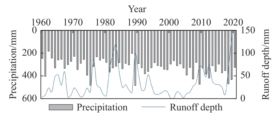
Fig.4 Relationship between precipitation and runoff from 1960 to 2020 in the SAYR
3.2.2 Analysis of the causes of abnormal runoff
Within the geological context of plateau uplift, the SAYR experiences widespread river erosion and undercutting.Notably, Eling Lake, functioning as an overflow lake of the Yellow River, has a central water surface width of approximately 20 km and a downstream river channel width of roughly 20 m.The lowest elevation at the lake's outlet profoundly influences its water level and discharge volume.As water flows from the lake centre to the outlet, the narrowing of this section accentuates the erosion impact of lake water on the downstream channel.Consequently, the downstream outlet of Eling Lake has become the area with the most pronounced erosion in the SAYR.This effect becomes particularly noticeable during the rainstorm season when the quaternary loose sediment in the riverbed becomes exceptionally vulnerable to flood erosion, resulting in a rapid decline in the discharge base level.
During the construction of the Eling Lake Estuary Hydrological Station in 1989, measurement of the riverbed bottom displayed the consequences of heavy rainfall-induced floods in July and August.Over the period from June 25 to October 19, the lowest elevation of the riverbed dropped from 4,265.34 m to 4,264.83 m, representing a decrease of 0.51 m.In the meantime, the lake's water level elevation rose from 4,268.74 m to 4,269.13 m,marking an increase of 0.39 m.Downstream along the Yellow River at the hydrological station, the total runoff between July and October amounted to 14.3 × 10⁸m3, which is 3.7 times the annual average for the same period.Although runoff decreased after October and reached its lowest point in February 1990 (0.77 × 10⁸m3), this value still surparssed the runoff observed in February 1989 and February 1991, by a factor of 7.0 and 3.7, respectively.The difference between the lake water level in June 1989 and the lowest riverbed elevation at Eling Lake outlet represents the initial water flow state.According to the measurement results on October 19, it became apparent that to restore the conditions to the June state, the lake water level must decrease by 0.9 m, representing a discharge of which is 5.49 × 10⁸m3of lake water.Based on the monthly runoff estimates, heavy precipitation and the decreased elevation at the lake mouth and river bottom could be entirely discharged in December of the same year.However, the runoff between January and April in 1990 increased by 3.95 × 10⁸m3compared with the same period in 1989 (Fig.5a), primarily due to freezing conditions preventing precipitation from effectively supplementing runoff.Consequently, this runoff increase is inevitably related to the increased groundwater discharge, which is, in turn, caused by the diminished discharge base level.

Fig.5 Monthly precipitation-runoff process in Huangheyan hydrographic station
In addition to soil media and precipitation, the runoff generation in the SAYR is primarily dominated by its full storage (Zhu et al.2022a).The substantial groundwater discharge leads to a decline in groundwater levels, increasing water transport distances and storage spaces within the aeration zone.This, in turn, extends the duration of soil full storage and runoff production while increasing the proportion of atmospheric precipitation that infiltrates the surface (Li et al.2016).Ultimately, these factors result in a reduction in surface runoff production capacity.These changes in the runoff process led toa relatively stable hydrograph for the entire year of 1990, with no significant flooding occurred during the heavy rainfall of 120.7 mm in August 1991 (Fig.5a).Examining long-term trends in precipitation-runoff,during the periods of 1989-1990 and 1991-1992,total precipitation was 779.1 mm and 728.3 mm,respectively.However, runoff decreased by a substantial 74.7% (from 32.4 × 10⁸m3to 8.21 ×10⁸m3)during the latter period, despite only a 6.5% decrease in precipitation.This result indicates how the rapid decline in the discharge baseline amplifies the impact of groundwater discharge on the precipitation -groundwater surface conversion, a significant and long-term process within the SAYR.
According to the measured data in 1989, the process of "channel cut down-increase of groundwater excretion" and precipitation-runoff patterns over preceding years were obtained (Fig.5b).Notably, erosion and undercutting likely occurred at the bottom of the Erling Lake estuary during specific periods such as 1964-1967, 1976, and 1981-1984.These periods were characterized by highintensity monthly rainfall during the rainy season,resulting in elevated peak floods and increased winter runoff.When examining long-term trend, it is possible that a cyclical erosion and downcutting process occurs at the bottom of the Eling Lake estuary, driven by periodic changes in precipitation.The primary reason behind the abnormal relationship between precipitation and runoff in several years is the decline in the discharge base level, which leads to the storage of lake water and the substantial groundwater discharge.
3.2.3 Analysis of controlling factors on the evolution of water balance
Within the unique climatic, hydrological, and geological setting of the SAYR, the erosion of its riverbed and the Eling Lake outlet has led to a reduction in the lake's water level.This decline has contributed to a diminished regional groundwater discharge baseline and enhanced groundwater and lake water discharge intensity.These effects not only prevent the lake from expanding its water storage during the high-water season but also result in increased water releases.Consequently, a negative equilibrium state of water balance occurs when the output from the "water tower" at the source of the Yellow River surpasses the input.Over an extended period of negative equilibrium,the water deficit becomes more severe, prompting additional precipitation to compensate for this deficit in the basin.This, in turn, diminishes the basin's runoff production capacity and leads to runoff attenuation.The water level change curve of Eling Lake reveals a fluctuating downward trend from 1978 to 1998.In 1998, the lake's lowest water level reached 4,268.11 m, signifying a decline of 0.79 m compared with 1978's level of 4,268.9 m.Field investigations, measurements, and interviews with local residents confirmed this trend,indicating that the lake's lowest water level in the late 1990s was 2-3 m lower than levels observed in the 1950s and 1960s.After 2000, owing to the construction and operation of the Yellow River Source Hydropower Station, the reservoir area connected with the upstream Eling Lake, causing water levels to fluctuate but maintain relative stability.In 2012, the highest water level reached 4,270.79 m, representing an increase of 2.68 m compared to the 1998 level.Additionally, the lake's surface area, including the storage area of the Yellow River Source Hydropower Station,expanded by 59.1 km2(Fig.6), and its storage capacity increased by approximately 25 × 108m3.The construction of the Yellow River Source Hydropower Station dam objectively prevented the riverbed incision at the lake's outlet, elevated the basin's drainage base level, and reduced the discharge intensity of groundwater and lake water.Consequently, the initial water resource gap was gradually filled and converted into a surplus.Runoff subsequently began to recover, with base flow remaining high and stable during the dry season, especially during the hydropower station's water storage period (Fig.5b).
Comparing the water level change curve of Eling Lake (Fig.6) with the cumulative anomaly change curve of water storage variables in the SAYR (Fig.2) shows a high degree of consistency in their temporal patterns.This alignment is especially evident during the mid to late 1990s when both the lake's water level reached its lowest point since the 1950s and 1960s, and the cumulative anomaly of water storage variables was at its lowest point in the 1990s.After 2010, as the lake's water level fluctuated, the cumulative anomaly of water storage variables similarly oscillated, indicating a close correlation between these two sets of variables.Through a comparative analysis of the SAYR's water balance evolution and changes in precipitation, evapotranspiration, and discharge base levels, it becomes evident that the latter,controlled by the lake's water level, serves as the primary controlling factor.In this context, the Yellow River Source Hydropower Station plays a positive role in elevating the discharge base level,maintaining the basin's water balance and ensuring runoff stability.
3.3 Hydrological and ecological effects of water balance evolution
3.3.1 Impact on changes in runoff production conditions
The analysis of trend in precipitation-runoff variations and precipitation guarantee rates in 1960-2000 and 2001-2020 (Figs.7, 8) reveals significant difference in the relationship between precipitation and runoff production between the negative and positive equilibrium stages.In the period of negative equilibrium (1960-2000), it is observed that the same amount of precipitation generates more runoff during both normal and dry years compared to the positive equilibrium state.During wet years, however, this relationship is reversed.This phenomenon is attributed to the fact that, in the negative equilibrium stage, the lowering of the discharge base level leads to an increase in the basin's drainage capacity, leading to a substantial water deficit during the flat and dry years.Conversely, during wet years, precipitation primarily replenishes the water deficit caused by the large amount of runoff discharge during the flat and dry years, leading to a decrease in the runoff production capacity.In contrast, during the positive equilibrium stage, the elevation of the discharge base level enhances the basin's water storage capacity.This results in a relatively abundant water supply during normal and dry years, leading to a stronger runoff production capacity during wet years.

Fig.6 Changes of water level and lake area in the Eling Lake
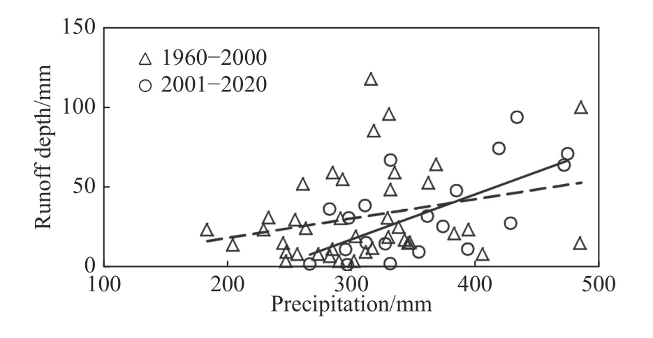
Fig.7 Comparison of the relationship between precipitation and runoff production

Fig.8 Precipitation frequency analysis at different water equilibrium stages
Examining the monthly runoff data from hydrological stations along the Yellow River, seven flow interruptions occurred during the dry season since 1960 (Table 1).With the exception of 2004, which was related to human regulation during the initial impoundment of the Yellow River Source Hydropower Station, all interruptions happened under natural conditions.Notably, the years 1961 and 1980 witnessed significantly lower precipitation compared to the annual average, suggesting that insufficient precipitation played a key role in causing these river flow interruptions.In contrast, a four-year consecutive interruption period occurred from 1997 to 2000, with the duration gradually increasing, peaking at four months.During this period, precipitation was close to or even exceeded the annual average, while evapotranspiration showed no significant increase.Therefore, simple changes in precipitation and evapotranspiration were evidently not the determining factors behind these frequent interruptions along the Yellow River section at the end of the 20thcentury.Considering the chronological alignment between changes in water balance, runoff attenuation, and frequent flow interruptions in the SAYR, it becomes clear that these interruptions were a concentrated manifestation of the basin's long-term imbalance of water at the end of the 20thcentury.The imbalance resulted from the declining discharge base level,subsequently leading to a reduced runoff production capacity.
3.3.2 Impact on changes in lakeside wetlands
One of the critical ecological zones in the SAYR is the alpine swamp wetlands on the shorelines of Zhaling and Eling Lakes.These wetlands primarily host shallow-rooted herbaceous plants that thrive in water-rich environments and are highly responsive to fluctuations in groundwater levels(Jin et al.2009).The analysis of the evolving trends and underlying causes of the SAYR's water balance reveals that, during the period of accumulated water deficit, the reduction in the discharge baseline exacerbates groundwater discharge, leading to a decline in groundwater reserves and water levels.When groundwater levels drop below the root systems of these water-dependent plants, they wither and die.Furthermore, the decrease in water content in the surface soil layer reduces its cohesion, exacerbating the degradation of swamps and wetlands and promoting soil desertification.In contrast, as the water balance gradually returns to equilibrium, the elevation of the discharge baseline leads to a reduction in groundwater discharge and an increase in groundwater reserves and water levels, thereby meets the water needs of the shallow-rooted vegetation on the surface.Consequently, the swamp wetlands begin to recover, as shown in Fig.9.
The Tangchama Wetland, situated along the southwest lakeside of the Eling Lake and formed by groundwater overflow from the front edge of the Lena River alluvial fan, is one of the largest alpine swamp wetlands in the SAYR.During the 1990s, it experienced a notable reduction in size retreating approximately 300 m upstream due to factors like decreased precipitation and permafrost degradation.However, since the beginning of the 21stcentury, the wetland ecosystem in the SAYR has exhibited an overall improvement.While many have attributed to this positive shift to meteorologi-cal factors, such as increased precipitation, a closer examination was needed, particularly concerning the Tangchama Wetland.To understand the precise impact of precipitation and the evolution of watershed water balance, 1998 and 2015 were selected as representative years for a comparative analysis of the changes in the Tangchama Wetland.In 1998, the area received 343.4 mm of precipitation,and Lake Eling's water level stood at 4,268.11 m.By 2015, precipitation has slightly decreased to 298.6 mm, and the lake's water level had risen to 4,270.14 m.Remote sensing data revealed that from 1998 to 2015, the average shoreline on the west bank of Eling Lake had extended by roughly 2,600 m.Additionally, the groundwater overflow area had moved approximately 500 m upstream.The Tangchama Marsh Wetland had expanded from 90.87 km2to 111.65 km2.Notably, along its periphery, the coverage of medium and highdensity grasslands had significantly increased,while low-density grasslands had diminished (Fig.10).
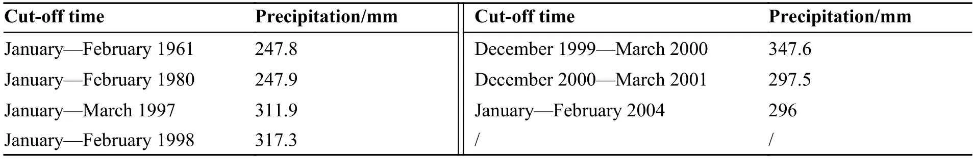
Table 1 Statistics of interruptions in Huangheyan hydrographic station
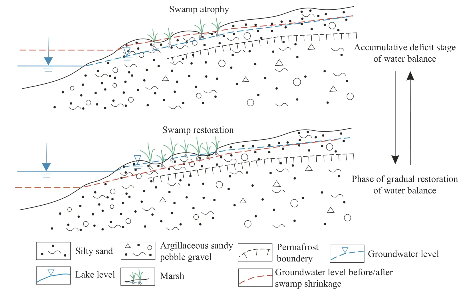
Fig.9 Models of wetland evolution in lakeshore zone at different water equilibrium stages
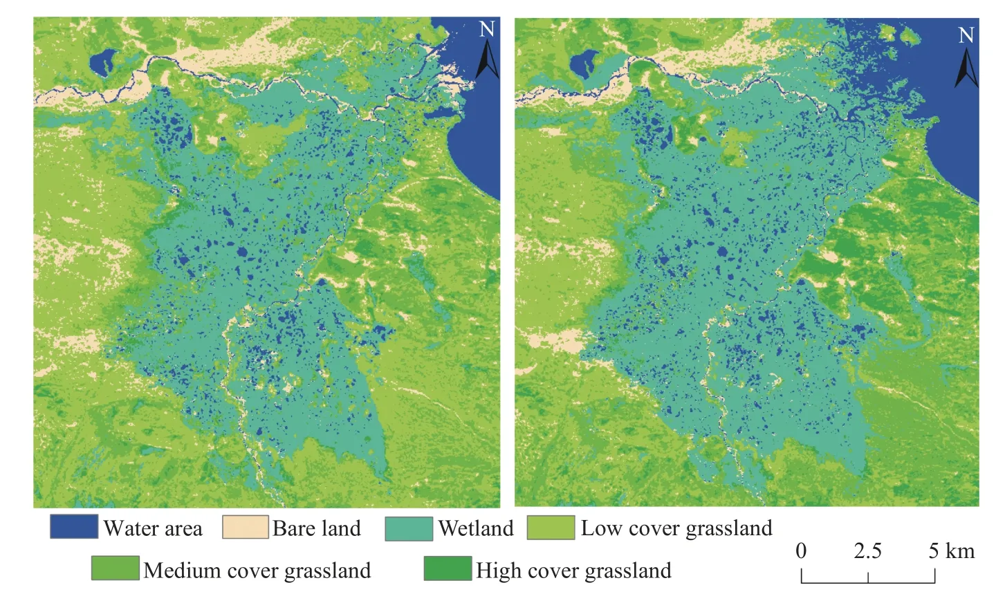
Fig.10 Comparison between 1998 (left) and 2015 (right) of Tangchama Wetland
An analysis of the relationship between precipitation, lake water level and wetland changes in these two years indicated that despite reduced precipitation in 2015, the rising lake water levels and discharge baseline during the gradual restoration of the water balance were able to maintain a high groundwater level along the lakeside area.Consequently, the wetland did not experience further shrinkage.In summary, while ample precipitation certainly benefits the restoration of the wetland ecosystem in the SAYR, changes in marsh wetlands along the lakeshore are more closely related to shifts in the discharge baseline, which significantly impact the basin's water balance.
4 Conclusion and suggestions
In the context of the Qinghai-Tibet Plateau's uplift and increased river erosion, changes in the discharge base level due to river bed elevation emerge as the primary driving factors behind the water balance evolution in the SAYR.The attenuation of runoff and its frequent interruption experienced in the late 20thcentury were not directly related to meteorological factors like precipitation and evaporation.Instead, they manifested a long-term water imbalance issue in the basin caused by the declining discharge base level.The construction of the Yellow River Source Hydropower Station played a vital role in halting further erosion of the riverbed at the lake outlet.It raised the discharge baseline within its controlled basin, increased the lake and groundwater storage capacity, and effectively curbed the trend of runoff attenuation and frequent interruptions.The elevated discharge base level led to a reduction in groundwater discharge intensity and volume, significantly contributing to the enhancement of the alpine wetland ecosystem along the lakeside and water source conservation.
However, after the demolition of the Yellow River Source Hydropower Station dam in 2022,the natural runoff state downstream of Eling Lake was reinstated.Under the influence of extreme rainfall, the loose quaternary sediment at the lake mouth faced continued erosion and cutting by floods.Consequently, the discharge baseline exhibited a steady decline before the year 2000.Predictably, this extensive discharge of lake water and surrounding groundwater may shift the water balance in the source area from positive to negative equilibrium in the future.This poses a significant risk of runoff attenuation and even winter flow interruption in the source area.Additionally, also it could negatively impact alpine vegetation ecosystems, especially those reliant on groundwater in the lakeshore zone.In light of these findings, the current analysis recommend the reinforcement of the mouth of the Eling Lake to prevent further sediment erosion in the riverbed.This will effectively impede a decrease in the drainage base level and water storage capacity in the basin, maintaining runoff stability in the SAYR and protecting the wetland ecosystem along the lakeside.
The surrounding area of Eling Lake is designated as a national first-class ecological protection zone, prohibiting hydrogeological survey activities.Consequently, essential hydrogeological parameters for groundwater balance research are unavailable.Therefore, changes in groundwater discharge and levels caused by the declining discharge baseline are inferred through observations of winter runoff and lakeside wetlands.This gap in direct observation data presents certain limitations in this research.After the demolition of the hydropower station, continuous monitoring and research efforts are imperative to monitor the runoff and wetland changes in the SAYR accurately.Therefore, it further supports the validation of the statement proposed in this article that changes in the discharge baseline control the water balance in the basin; additionally, it provides scientific support for the ecological protection of the wetland in the lakeside zone.
Acknowledgements
This work was funded by China Geological Survey Program (DD20230422) and Chinese Academy of Geological Sciences Basic Research Fund Program(SK202214).
杂志排行
地下水科学与工程(英文版)的其它文章
- Factors driving surface deformations in plain area of eastern Zhengzhou City, China
- Analytical solution for Non-Darcian effect on transient confined-unconfined flow in a confined aquifer
- Electrical geophysical evaluation of susceptibility to flooding in University of Nigeria, Nsukka main campus and its environs, Southeastern Nigeria
- Using geospatial technologies to delineate Ground Water Potential Zones(GWPZ) in Mberengwa and Zvishavane District, Zimbabwe
- Simulation of thermal breakthrough factors affecting carbonate geothermalto-well systems
- Effects of coal mining and tunnel excavation on groundwater flow system in karst areas by modeling: A case study in Zhongliang Mountain,Chongqing, Southwest China