基于Newmark模型的积石山6.2级地震滑坡快速评估
2024-01-01马星宇王兰民蒲小武许世阳


摘要:2023年12月18日甘肃临夏回族自治州积石山县发生6.2级地震,引发大量的滑坡和崩塌等地质灾害。基于黄土高原强震数据库中2013年岷县—漳县6.6级地震的地震动记录回归分析所得的Newmark位移预测模型,利用震前精度为30 m分辨率地形以及1∶250万地质图等数据,考虑竖向地震加速度以及冬灌的影响,对距震中扩展100 km范围内的地区进行滑坡危险性快速评估,并与震前地质灾害分布以及震后遥感解译和实地调查结果进行对比。研究结果显示:静态安全系数较低的区域更容易发生地质灾害;滑坡危险区主要位于距震中27 km的范围内,危险区内河道和分水岭发育,地层以新近系和第四系为主,与已有研究结果的重合度较高。研究表明,Newmark位移法适用于积石山区域内的震后滑坡危险性评价,但其并未考虑土体液化的情况,低估了液化灾害发生的危险程度。
关键词:Newmark位移; 区域滑坡危险性分析; 竖向地震加速度; 快速评估
中图分类号: P319文献标志码:A文章编号: 1000-0844(2024)04-0825-11
DOI:10.20000/j.1000-0844.20240310001
Rapid assessment of landslides induced by the Jishishan
MS6.2 earthquake based on Newmark modelMA Xingyu WANG Lanmin PU Xiaowu XU Shiyang(1. Key Laboratory of Earthquake Engineering and Engineering Vibration, Institute ofEngineering Mechanics, CEA, Harbin 150080, Heilongjiang, China;2. Key Laboratory of Loess Earthquake Engineering of CEA amp; Gansu Province, Lanzhou 730000, Gansu, China)Abstract: "On December 18, 2023, an MS6.2 earthquake hit Jishishan County, Linxia Hui Autonomous Prefecture, Gansu Province. This phenomenon induced numerous geological disasters, such as landslides and collapses. The Newmark displacement prediction model was first derived from the regression analysis of ground motion records of the 2013 Minxian-Zhangxian MS6.6 earthquake in the strong earthquake database of the Loess Plateau. Therefore, considering the vertical seismic acceleration and the influence of winter irrigation, a rapid assessment of landslide risk in the area within 100 km from the epicenter was conducted using 30-m resolution topography and a 1:2.5 million geological map before the earthquake. Assessment results were compared with the distribution of geological disasters before the earthquake and the results of remote sensing interpretation and field investigation after the earthquake. The comparative results reveal that areas with low static safety factors are prone to geological disasters. The landslide risk area is mainly located within 27 km from the epicenter, where the channels and watersheds are highly developed, and the strata mainly comprise Neogene and Quaternary formations, demonstrating high similarity to the existing research results. The study demonstrates that the Newmark displacement method is appropriate for assessing post-earthquake landslide risk in the Jishishan area. However, the Newmark displacement method overlooks soil liquefaction, thereby underestimating the degree of danger of liquefaction.
Keywords:Newmark displacement; regional landslide hazard analysis; vertical seismic acceleration; rapid assessment
0引言
滑坡作为地震诱发的主要次生灾害之一,不仅能直接造成人员伤亡和财产损失,其产生的滑坡堆积体还会掩埋道路、堵塞河流,从而延缓救援进度,加剧震害损失[1-2]。2008年汶川地震、2010年玉树地震以及2022年泸定地震等多次强震均出现了滑坡掩埋村庄、堵塞救援道路的情况[3-5]。由此可知,震后区域滑坡危险性的快速评估对判断受灾区域和震后救援均具有极其重要的意义。目前,国内外针对震后区域滑坡危险性评估的方法较多,主要有层次分析法、权重分析法、数值模拟法、Newmark位移法以及机器学习方法等[6-8]。其中Newmark位移法具有物理力学机制明确、计算简便以及所需参数较少等优点,尤其在研究区域缺少历史灾害目录以及因天气原因导致的遥感影像不清晰的条件下,Newmark位移法的优势更为显著[9]。
Newmark位移的计算方法主要有3种,分别为刚性块体法、解耦以及耦合计算[10]。刚性块体法为传统的Newmark位移分析法,将滑体假定为刚体,当向下的地震加速度a超过临界加速度ac时,滑体向下运动,对超过部分的a进行二次积分,获得滑体累加位移[11]。解耦计算和耦合计算是对刚性块体计算的改进,突破了滑体为传统刚体的假定[12]。解耦计算分为两个部分:首先假设没有明确的滑移面,利用数值模拟程序计算土体在地震过程中相应滑体的平均加速度时程k;然后将k与ac进行比较,计算累计位移。耦合计算则更加复杂,将滑体的动力响应和位移一起分析,以考虑滑动位移对滑体地震动响应的影响[10]。相较于刚体位移方法,解耦和耦合计算适用于滑体厚度更深、更加复杂的情况[12-14]。在区域危险性分析中,须针对每一个栅格进行Newmark位移计算。但按照目前的台站密度以及计算条件,严格的Newmark方法是不现实的[15]。因此,国内外研究人员在利用Newmark模型进行区域地震滑坡危险性分析时,多采用基于强震动记录回归得到的Newmark经验模型进行分析[16]。由于解耦和耦合方法在计算时需要更为详细的参数信息以及更加复杂的运算,尽管也有研究人员基于解耦或耦合的方法开发了相应区域的Newmark经验模型[17-19],但上述两种方法主要用于单体滑坡的地震位移计算[20-22]。在进行区域危险性分析时,大多都基于传统刚性块体假定,通过对已有强震动记录进行回归分析,得到不同的Newmark经验模型[23-26],并取得了大量的应用成果[27-30]。
2023年12月18日23时59分,甘肃临夏回族自治州积石山县发生6.2级地震,震源深度为10 km。此次地震共造成151人死亡,980人受伤,同时诱发了许多的地质灾害[31]。震后,许多研究人员基于实地调查和卫星影像对此次地震诱发的地质灾害进行了分析,取得了一系列的研究成果。王立朝等[32]在震后甘肃、青海两省地质灾害隐患核查的基础上,对积石山地震诱发地质灾害的特征、控制因素、发展趋势进行了分析,研究表明,地质灾害主要分布于发震断层附近,发育密度随地震烈度增强而增大,且断层上盘效应较为显著。黄观文等[33]基于实时全球导航定位系统(Global Navigation Satellite System,GNSS)和加速度数据,对远场易发区滑坡潜在危害性进行了评估,发现积石山地震对距震源 64 km以内的滑坡易发区影响较大。陈博等[34]基于历史滑坡清单以及峰值加速度(Peak Ground Acceleration,PGA)分布,利用支持向量机模型给出了此次地震诱发滑坡的概率以及空间分布,同时,基于地震前后的卫星影像实现了积石山地震诱发同震滑坡的应急识别,并对滑坡的影响因素进行了分析。铁永波等[35] 采用地面调查、遥感解译和空间叠加统计等方法,对积石山和泸定地震地质灾害发育分布特征和控灾因子的差异性进行了研究。李为乐等[36]基于多源高分辨率遥感解译和已有研究成果对比分析,初步揭示了该次地震地质灾害的基本特征和发育分布规律。刘帅等[37]通过应急排查和野外调查,对震后积石山县地质灾害的基本类型、空间分布特征和发育规律进行了研究,同时,基于调查结果,利用随机森林模型对积石山县内的同震地质灾害进行了易发性评价。郭富赟等[31]通过遥感解译和实地调查,对此次地震诱发地质灾害的类型、空间分布规律和发育特征进行了详细研究。陈鹏等[38]基于合成孔径雷达干涉测量(Interferometric Synthetic Aperture Radar,InSAR)和光学影像对积石山地震诱发地质灾害进行解译,共解译以小型黄土滑坡为主的滑坡4 996处,且绝大部分位于震中距5~30 km的范围内。刘晓杰等[39]基于遥感影像,采用机器学习方法,快速建立了积石山地震震后滑坡目录,并给出了滑坡的分布特征。
由上可知,Newmark位移法具有物理力学机制明确、计算简便、所需参数较少、不受滑坡清单以及遥感影像限制等优势。本文利用黄土高原地震数据库中2013年岷县—漳县6.6级地震强地震动记录回归分析所得的Newmark位移预测模型,基于震前30 m分辨率地形数据以及1∶250万地质图等资料,考虑竖向地震加速度以及冬灌的影响,对积石山震中扩展100 km范围内的滑坡危险性进行评价,并与已有的调查结果进行对比。研究结果旨在为Newmark位移法在积石山地区的适用性、震后斜坡危险性评估、灾后救援和重建提供较为科学的参考依据。
1区域地震地质概况
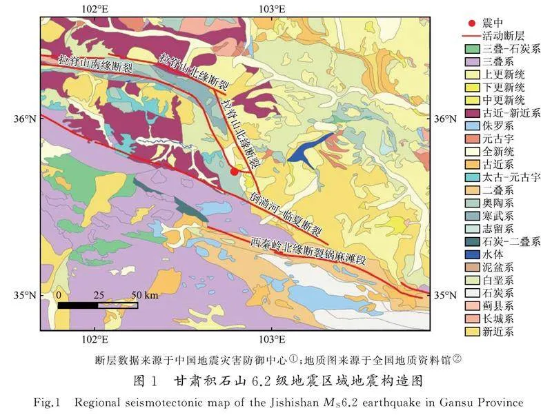
2023年积石山6.2级地震的震中位置为35.70°N、102.79°E,震源深度为10 km。此区域为甘东南活动构造区,属于青藏高原东部南北地震带[40]。区域内的主要活动断裂有西秦岭北缘断裂、拉脊山断裂带以及倒淌河—临夏断裂等。此次地震为逆冲型地震,破裂面呈现SE—NW走向,发震断裂为拉脊山北缘断裂[41]。研究区出露的地层有前白垩系、古近系、新近系和第四系等。其中第四系地层较为完整,主要有下更新统(Qp1)、中更新统(Qp2)、上更新统(Qp3)以及全新统(Qh),主要分布于河流两侧、冲沟及盆地内。下更新统(Qp1)主要为五泉山组(下部为冲积砾石层,上部为洪积微胶结砾石层夹粉砂质黏土)。中更新统(Qp2)主要为黏质砂土、砂砾石层。上更新统(Qp3)主要为黄土、砾石层、亚砂土和亚黏土层。全新统(Qh)主要为冲洪积砂、砾石层以及亚砂土[42](图1)。
2震后滑坡危险性快速评估
2.1Newmark模型基本原理
Newmark于1965年提出一种评价坝体地震稳定性的简化模型。该模型将滑体简化为刚体,认为滑体在地震作用下会沿着最危险的滑面运动,当向下的地震加速度a超过临界加速度ac时,滑体向下运动,累加位移达到临界状态时,斜坡失稳[11](图2)。
2.2静态安全系数和临界加速度
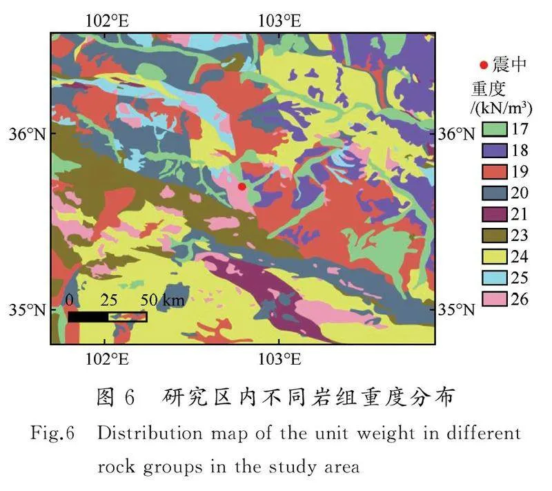
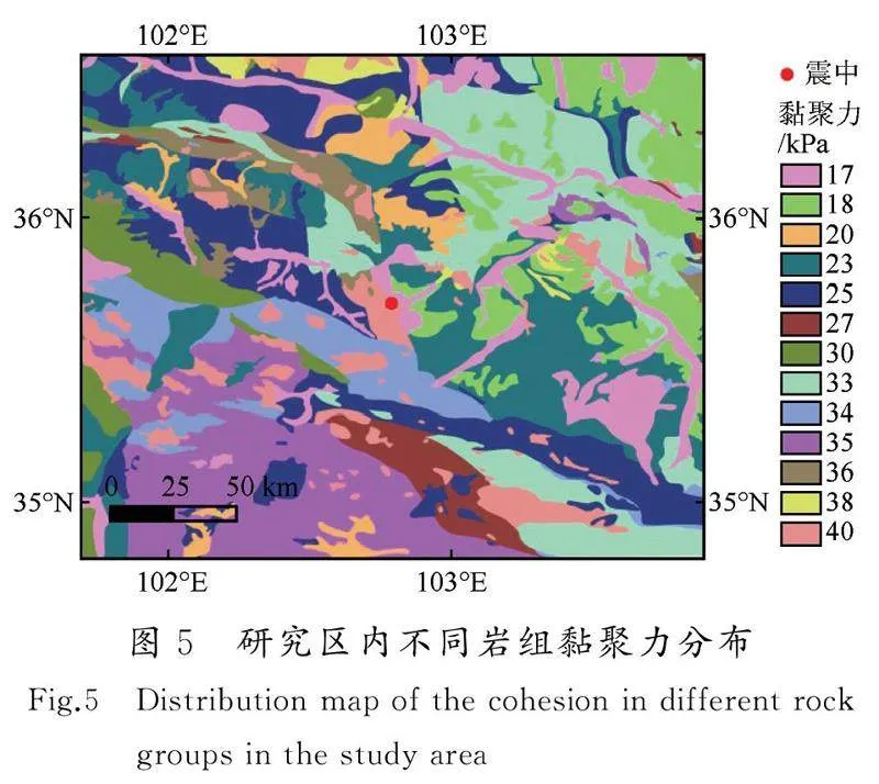
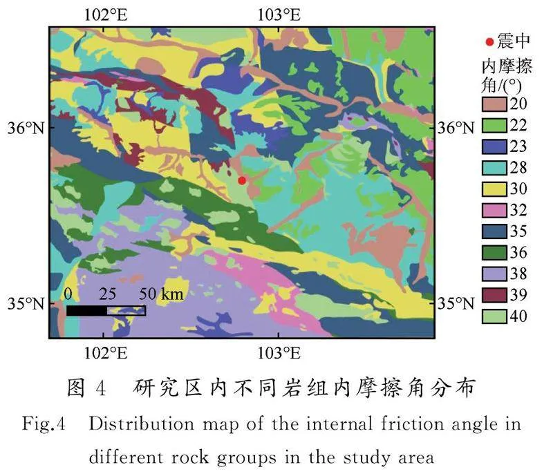
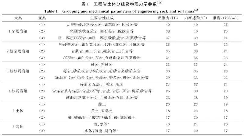
本文在1∶250万公开版地质图的基础上(图1),对积石山地震震中100 km范围内的区域进行了工程地质分组。分类依据主要参考1∶250 万地质图以及前人研究结果[30]。不同岩组的物理力学参数按王涛等[43]的研究成果进行赋值(表1),赋值结果如图4~6所示。
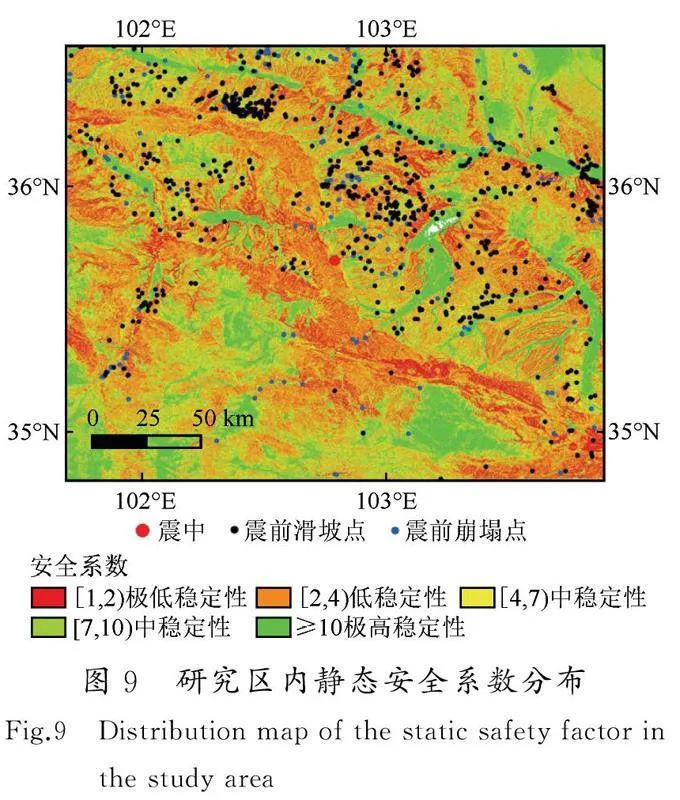
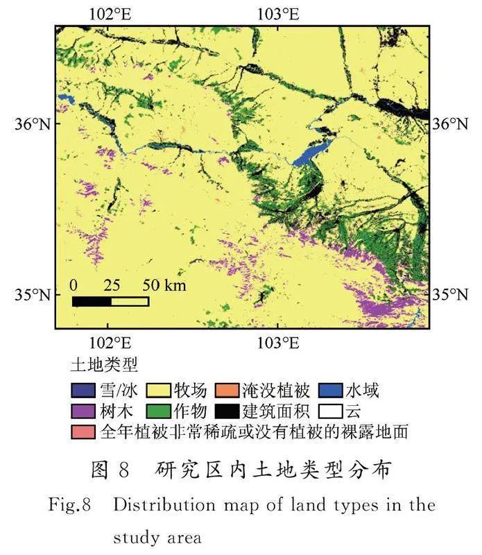
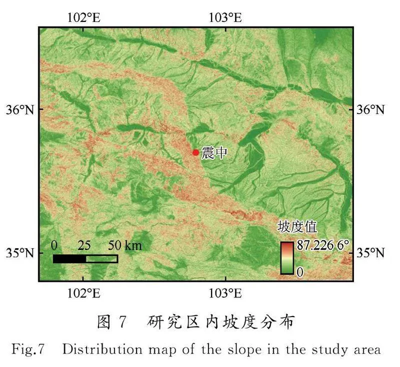
本文坡度数据由国家冰川冻土沙漠科学中心提供,分辨率为30 m,如图7所示。根据式(1),基于ArcGIS平台,对震中100 km范围内区域的静态安全系数进行计算。在计算过程中滑体厚度d取为3 m[30];由于震前未发生大规模的降雨,岩土体的饱和程度m取为0,但考虑到冬灌的影响,将有农作物的地区的m取为50%(图8)。此外,在计算过程中出现了部分区域的安全系数小于1的情况,这是由于同一岩组包含不同的岩层,而在赋予参数时赋予了同样的参数,这就导致部分地区的安全系数不符合实际情况。参照马思远等人的做法,将此部分区域的静态安全系数赋值为1.01[27],所得结果如图9所示。根据图9可知,历史灾害点(滑坡和崩塌)主要分布于低稳定性和中稳定性的区域,表明岩体分组以及物理力学参数较为符合实际情况。通过静态安全系数的分布,可以为工程选址以及灾害预防提供一定程度的参考。在得到静态安全系数的基础上,利用式(2)获取研究区域内临界加速度的分布,如图10所示。
2.3Newmark预测模型
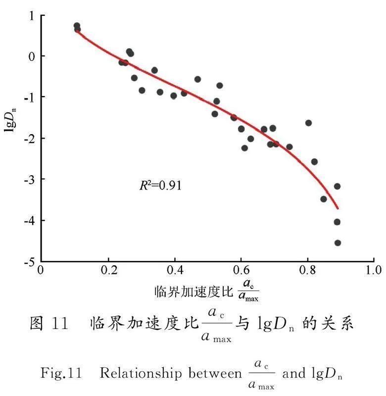
已有的研究表明,基于强震动记录回归得到的位移模型具有区域相关性[24,44]。Newmark位移预测模型中,Ambraseys于1988年提出的模型参数最为简单,仅有临界加速度比一项,故其应用也较为广泛[12,45]。本文在已有黄土高原地震数据库的基础上,基于震级、震中相近的原则,选取了2013年岷县—漳县6.6级地震的强地震动数据,对Ambraseys模型进行回归分析。为提高信噪比,在计算前对强震动记录进行基线校正和带通滤波(带通滤波的频率为0.1~25 Hz)。选取临界加速度ac为0.02g、0.05g、0.1g、0.15g、0.2g以及0.25g,对强震动记录中的正向加速度超过临界加速度ac的部分进行二次积分累加,获得Newmark位移值(图3)[44],拟合结果如图11所示,拟合公式如下[式(4)]:
2.5Nemark地震位移分布
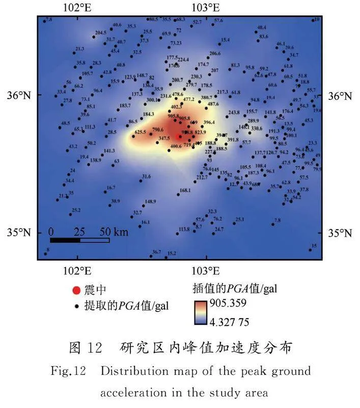
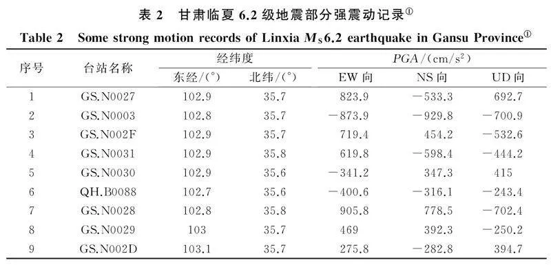
基于已得到的研究区域临界加速度值和PGA值(图10和图12),利用式(4),对研究区内的累计Newmark地震位移进行计算。据已有的强地震动数据可知(表2),此次积石山地震的竖向加速度较大①。研究表明,当竖向地震加速度较大时,会对Newmark位移值产生较大影响。因此,在利用式(4)得到区域Newmark位移值后,采用式(5)对其进行修正[46]:
危险区、中危险区、高危险区以及极高危险区[15] [图13(a)],并将其与已有的调查研究结果进行对比[图13(f)~(i)][34,36,38-39]。由图13(a)和图13(f)~(i)可知,Newmark位移区主要位于距震中27 km的范围内,与陈鹏等[38]基于InSAR 和光学影像解译所得震中距范围相符。Newmark位移区主要涉及积石山县、循化撒拉族自治县以及民和回族土族自治县等,靠近震中位置的Newmark位移较大,但整体Newmark位移值偏小,表明此次地震灾害主要以中小规模黄土滑坡和浅表层岩质崩塌为主,且崩塌的数量相对较多[31,36]。Newmark位移区沿断层两侧分布,表现为受逆冲构造的“上下盘效应”[31]。已有的研究表明,河道以及分水岭对滑坡具有较大的影响[48]。由图13(b)和(c)可知,Newmark位移分布区内河道、分水岭较为发育,表明此区域地形复杂。分水岭处裂隙较为发育,结合此区域高程较大[图13(e)]以及构造活动强烈等因素,可推测区域内的表面松散堆积物较为丰富,这为滑坡的发生提供了地形和物质基础。由图13(d)可知,Newmark位移主要分布区内主要以新近系(泥岩、杂黏土等)以及第四系(黄土、砂土等)为主,这是由于黄土具有较强的地震易损性,较易产生滑坡以及崩塌等地质灾害。这也验证了此次积石山地震诱发地质灾害的空间特征为软弱黄土地质环境的显著控制[31]。
综上可知,产生Newmark位移的区域与基于遥感影像解译,以及实地调查所得范围重合度较高,表明Newmark位移法在积石山区域具有较强的适用性。此外,图13(a)中出现了一些零散栅格的Newmark位移值过大,这是由于强行对静态安全系数小于1的区域赋值为1.01,对整体结果影响较小。此外,在地震中造成严重伤亡的青海省海东市民和县永川乡金田村和草滩村液化滑移灾害并未被划分成中高风险区,这是因为Newmark位移模型并未考虑土体液化的情况,低估了液化灾害发生的风险。
3结论
本文基于2013年岷县—漳县6.6级地震强地震动记录回归分析所得的Newmark位移预测模型,利用震前30 m分辨率地形数据以及1∶250万地质图等数据,考虑竖向地震加速度和冬灌的影响,对距离积石山6.2级地震震中100 km范围内的区域的滑坡危险性进行了评估,得出如下结论:
(1) 根据与已有灾害点的对比,静态安全系数较低的区域更容易发生地质灾害,在工程建设中应采取相应的安全措施。
(2) 滑坡危险区内河道以及分水岭较为发育、海拔较高、构造活动强烈、地层以第四系和新近系为主,为滑坡的发生提供了物质条件。
(3) 滑坡危险区与已有的调查结果重合度较高,表明Newmark位移法适用于积石山地区的震后滑坡危险性快速评估。在类似研究区域内缺少历史灾害目录以及在震后因天气原因导致的遥感影像不清晰的条件下,可采用Newmark位移法对震后滑坡危险性进行快速评估,用于判断受灾区域和指导救援。
(4) Newmark位移法未能考虑土体液化情况,低估了液化流滑灾害发生的风险。
本文采用的研究区域的资料比例尺较大,研究的主要目的是验证Newmark预测模型在积石山地区的适用性。随着研究资料精度的提升,所得结果的准确度也将不断增加。致谢:衷心感谢中国地震局工程力学研究所万卫博士、彭达博士以及哈尔滨工业大学苏浩然博士在资料收集和软件使用中提供的帮助。感谢中国地震灾害防御中心地震活动断层探察数据中心(https://www.activefault-datacenter.cn)提供数据支撑。分析过程中使用的地形数据、历史灾害数据,及土地类型数据均由自国家冰川冻土沙漠科学中心提供,1∶250 万地质图来源于全国地质资料馆,在此一并表示感谢。
参考文献(References)
[1]黄润秋.20世纪以来中国的大型滑坡及其发生机制[J].岩石力学与工程学报,2007,26(3):433-454.HUANG Runqiu.Large-scale landslides and their sliding mechanisms in China since the 20th century[J].Chinese Journal of Rock Mechanics and Engineering,2007,26(3):433-454.
[2]殷跃平.汶川八级地震地质灾害研究[J].工程地质学报,2008,16(4):433-444.YIN Yueping.Researches on the geo-hazards triggered by Wenchuan earthquake,Sichuan[J].Journal of Engineering Geology,2008,16(4):433-444.
[3]崔鹏,韦方强,何思明,等.5·12汶川地震诱发的山地灾害及减灾措施[J].山地学报,2008,26(3):280-282.CUI Peng,WEI Fangqiang,HE Siming,et al.Mountain disasters induced by the earthquake of May 12 in Wenchuan and the disasters mitigation[J].Mountain Research,2008,26(3):280-282.
[4]许冲,徐锡伟,于贵华.玉树地震滑坡分布调查及其特征与形成机制[J].地震地质,2012,34(1):47-62.XU Chong,XU Xiwei,YU Guihua.Study on the characteristics,mechanism,and spatial distribution of Yushu earthquake triggered landslides[J].Seismology and Geology,2012,34(1):47-62.
[5]蔡晓光,常晁瑜,李孝波.四川泸定6.8级地震地质灾害调查[J].防灾科技学院学报,2022,24(4):11-22.CAI Xiaoguang,CHANG Chaoyu,LI Xiaobo.Investigation on seismic geological hazards of the Luding,Sichuan MS6.8 earthquake in 2022[J].Journal of Institute of Disaster Prevention,2022,24(4):11-22.
[6]PRADHAN B,MANSOR S,PIRASTEH S,et al.Landslide hazard and risk analyses at a landslide prone catchment area using statistical based geospatial model[J].International Journal of Remote Sensing,2011,32(14):4075-4087.
[7]KOHNO M,HIGUCHI Y,ONO Y.Evaluating earthquake-induced widespread slope failure hazards using an AHP-GIS combination[J].Natural Hazards,2023,116(2):1485-1512.
[8]HUANG D R,WANG G,DU C Y,et al.An integrated SEM-Newmark model for physics-based regional coseismic landslide assessment[J].Soil Dynamics and Earthquake Engineering,2020,132:106066.
[9]杨志华,张永双,郭长宝,等.基于Newmark模型的尼泊尔MS8.1地震滑坡危险性快速评估[J].地质力学学报,2017,23(1):115-124.YANG Zhihua,ZHANG Yongshuang,GUO Changbao,et al.Landslide hazard rapid assessment in the MS8.1 Nepal earthquake-impacted area,based on Newmark model[J].Journal of Geomechanics,2017,23(1):115-124.
[10]JIBSON R W.Methods for assessing the stability of slopes during earthquakes:a retrospective[J].Engineering Geology,2011,122(1/2):43-50.
[11]NEWMARK N M.Effects of earthquakes on dams and embankments[J].Géotechnique,1965,15(2):139-160.
[12]RATHJE E M,BRAY J D.An examination of simplified earthquake:induced displacement procedures for earth structures[J].Canadian Geotechnical Journal,1999,36(1):72-87.
[13]BRAY J D,RATHJE E M.Earthquake-induced displacements of solid-waste landfills[J].Journal of Geotechnical and Geoenvironmental Engineering,1998,124(3):242-253.
[14]SONG J,LU Z X,JI J,et al.A fully nonlinear coupled seismic displacement model for earth slope with multiple slip surfaces[J].Soil Dynamics and Earthquake Engineering,2022,159:107353.
[15]王涛,吴树仁,石菊松,等.基于简化Newmark位移模型的区域地震滑坡危险性快速评估:以汶川MS8.0地震为例[J].工程地质学报,2013,21(1):16-24.WANG Tao,WU Shuren,SHI Jusong,et al.Case study on rapid assessment of regional seismic landslide hazard based on simplified Newmark displacement model:Wenchuan MS8.0 earthquake[J].Journal of Engineering Geology,2013,21(1):16-24.
[16]JIBSON R W.Predicting earthquake-induced landslide displacements using Newmark's sliding block analysis[J].Transportation research record,1993,1411:9-17.
[17]RATHJE E M,ANTONAKOS G.A unified model for predicting earthquake-induced sliding displacements of rigid and flexible slopes[J].Engineering Geology,2011,122(1/2):51-60.
[18]MACEDO J,BRAY J,TRAVASAROU T.Simplified procedure for estimating seismic slope displacements in subduction zones[C]//Proceedings of the 16th World Conference on Earthquake Engineering. Santiago:[s.n.],2017.
[19]DU W Q,WANG G,HUANG D R.Evaluation of seismic slope displacements based on fully coupled sliding mass analysis and NGA-West2 database[J].Journal of Geotechnical and Geoenvironmental Engineering,2018,144(8):06018006.
[20]MAKDISI F I,SEED H B.Simplified procedure for estimating dam and embankment earthquake-induced deformations[J].Journal of the Geotechnical Engineering Division,1978,104(7):849-867.
[21]BAZIAR M H,REZAEIPOUR H,JAFARIAN Y.Decoupled solution for seismic permanent displacement of earth slopes using deformation-dependent yield acceleration[J].Journal of Earthquake Engineering,2012,16(7):917-936.
[22]JI J,WANG C W,CUI H Z,et al.A simplified nonlinear coupled Newmark displacement model with degrading yield acceleration for seismic slope stability analysis[J].International Journal for Numerical and Analytical Methods in Geomechanics,2021,45(10):1303-1322.
[23]JIBSON R W.Regression models for estimating coseismic landslide displacement[J].Engineering Geology,2007,91(2-4):209-218.
[24]HSIEH S Y,LEE C T.Empirical estimation of the Newmark displacement from the Arias intensity and critical acceleration[J].Engineering Geology,2011,122(1-2):34-42.
[25]RAJABI A M,MAHDAVIFAR M R,KHAMEHCHIYAN M,et al.A new empirical estimator of coseismic landslide displacement for Zagros Mountain region (Iran)[J].Natural Hazards,2011,59(2):1189-1203.
[26]CHOUSIANITIS K,DEL GAUDIO V,KALOGERAS I,et al.Predictive model of Arias intensity and Newmark displacement for regional scale evaluation of earthquake-induced landslide hazard in Greece[J].Soil Dynamics and Earthquake Engineering,2014,65:11-29.
[27]马思远,许冲,王涛,等.应用2类Newmark简易模型进行2008年汶川地震滑坡评估[J].地震地质,2019,41(3):774-788.MA Siyuan,XU Chong,WANG Tao,et al.Application of two simplified Newmark models to the assessment of landslides triggered by the 2008 Wenchuan earthquake[J].Seismology and Geology,2019,41(3):774-788.
[28]JIBSON R W,HARP E L,MICHAEL J A.A method for producing digital probabilistic seismic landslide hazard maps[J].Engineering geology,2000,58(3-4):271-289.
[29]陈晓利,单新建,张凌,等.地震诱发滑坡的快速评估方法研究:以2017年MS7.0九寨沟地震为例[J].地学前缘,2019,26(2):312-320.CHEN Xiaoli,SHAN Xinjian,ZHANG Ling,et al.Quick assessment of earthquake-triggered landslide hazards:a case study of the 2017 MS7.0 Jiuzhaigou earthquake[J].Earth Science Frontiers,2019,26(2):312-320.
[30]刘甲美,王涛,杜建军等.四川泸定MS6.8地震诱发崩滑灾害快速评估[J].水文地质工程地质,2023,50(2):84-94.LIU Jiamei,WANG Tao,DU Jianjun,et.al.Emergency rapid assessment of landslides induced by the Luding MS6.8 earthquake in Sichuan of China[J].Hydrogeology amp; Engineering Geolog Y,2023,50(2):84-94.
[31]郭富赟,张永军,窦晓东,等.甘肃积石山MS6.2地震次生地质灾害分布规律与发育特征[J].兰州大学学报(自然科学版),2024,60(1):6-12.GUO Fuyun,ZHANG Yongjun,DOU Xiaodong,et al.Distribution patterns and development characteristics of secondary geological hazards caused by the MS6.2 earthquake in Jishishan,Gansu[J].Journal of Lanzhou University (Natural Sciences),2024,60(1):6-12.
[32]王立朝,侯圣山,董英,等.甘肃积石山MS6.2地震的同震地质灾害基本特征及风险防控建议[J/OL].中国地质灾害与防治学报,(2023-12-28)[2024-05-10].https://link.cnki.net/urlid/11.2852.P.20231228.1352.002.WANG Lichao,HOU Shengshan,DONG Ying,et.al.Basic characteristics of co-seismic geological hazards induced by Jishishan MS6.2 earthquake and suggestions for their risk control[J/OL].The Chinese Journal of Geological Hazard and Control,(2023-12-28)[2024-05-10].https://link.cnki.net/urlid/11.2852.P.20231228.1352.002.
[33]黄观文,景策,李东旭,等.甘肃积石山6.2级地震对滑坡易发区的变形影响分析[J/OL].武汉大学学报(信息科学版),(2023-12-28)[2024-05-10].https://doi.org/10.13203/j.whugis20230490.HUANG Guanwen,JING Ce,LI Dongxu,et al.Deformation analysis of Jishishan MW6.2 earthquake on the landslide hazard area[J/OL].Geomatics and Information Science of Wuhan University,(2023-12-28)[2024-05-10].https://doi.org/10.13203/j.whugis20230490.
[34]陈博,宋闯,陈毅,等.2023年甘肃积石山MS6.2地震同震滑坡和建筑物损毁情况应急识别与影响因素研究[J/OL].武汉大学学报(信息科学版),(2024-01-02)[2024-05-10].https://doi.org/10.13203/J.whugis20230497.CHEN Bo,SONG Chuang,CHEN Yi,et al.Emergency identification and influencing factor analysis of coseismic landslides and building damages induced by the 2023 MS6.2 Jishishan (Gansu,China) earthquake[J/OL].Geomatics and Information Science of Wuhan University,(2024-01-02)[2024-05-10].https://doi.org/10.13203/J.whugis20230497.
[35]铁永波,张宪政,曹佳文,等.积石山MS6.2和泸定MS6.8地震地质灾害发育规律对比[J].成都理工大学学报(自然科学版),2024,51(1):9-21,59.TIE Yongbo,ZHANG Xianzheng,CAO Jiawen,et al.Comparative research of characteristics of geological hazards induced by Jishishan (MS6.2) and Luding (MS6.8) earthquakes[J].Journal of Chengdu University of Technology (Science amp; Technology Edition),2024,51(1):9-21,59.
[36]李为乐,许强,李雨森,等.2023年积石山MS6.2地震同震地质灾害初步分析[J].成都理工大学学报(自然科学版),2024,51(1):33-45,90.LI Weile,XU Qiang,LI Yusen,et al.Preliminary analysis of the coseismic geohazards induced by the 2023 Jishishan MS6.2 earthquake[J].Journal of Chengdu University of Technology (Science amp; Technology Edition),2024,51(1):33-45,90.
[37]刘帅,何斌,王涛,等.甘肃积石山县MS6.2地震同震地质灾害发育特征与易发性评价[J/OL].地质力学学报,(2024-02-04)[2024-05-10].https://link.cnki.net/urlid/11.3672.P.20240202.1443.002.LIU Shuai,HE Bin,WANG Tao,et al.Development characteristics and susceptibility assessment of co-seismic geological Hazards in Jishishan MS6.2 earthquake,Gansu Province[J/OL].Journal of Geomechanics,(2024-02-04)[2024-05-10].https://link.cnki.net/urlid/11.3672.P.20240202.1443.002.
[38]陈鹏,邱梁才,姚宜斌,等.基于InSAR和光学影像解译的2023年甘肃积石山MS6.2震后地表形变和灾害分析[J/OL].武汉大学学报(信息科学版),(2024-04-19)[2024-05-10].https://doi.org/10.13203/j.whugis20240074.CHEN Peng,QIU Liangcai,YAO Yibin,et al.Surface deformation and hazard analysis after the 2023 MS6.2 earthquake in Jishishan,Gansu Province based on InSAR and optical imagery interpretation[J/OL].Geomatics and Information Science of Wuhan University,(2024-04-19)[2024-05-10].https://doi.org/10.13203/j.whugis20240074.
[39]刘晓杰,赵超英,李滨,等.基于InSAR技术的甘肃积石山震区活动滑坡识别与动态形变监测[J/OL].武汉大学学报(信息科学版),(2024-04-07)[2024-05-10].https://doi.org/10.13203/j.whugis20240054.LIU Xiaojie,ZHAO Chaoying,LI Bin,et al.Identification and dynamic deformation monitoring of active landslides in the Jishishan earthquake area,Gansu,China using InSAR technology[J/OL].Geomatics and Information Science of Wuhan University,(2024-04-07)[2024-05-10].https://doi.org/10.13203/j.whugis20240054.
[40]王润妍,万永革,宋泽尧,等.2023年12月18日甘肃积石山6.2级地震震源机制及其对周围区域的应力影响[J].地震,2024,44(1):175-184.WANG Runyan,WAN Yongge,SONG Zeyao,et al.Focal mechanism and stress implication on the surrounding region of the Jishishan,Gansu MS6.2 earthquake on December 18,2023[J].Earthquake,2024,44(1):175-184.
[41]陆诗铭,吴中海,李智超.2023年12月18日甘肃省积石山6.2级地震的控震构造及特征[J].地震科学进展,2024,54(1):86-93.LU Shiming,WU Zhonghai,LI Zhichao.Seismic structure characteristics of the 18 December 2023 M6.2 Jishishan earthquake,Gansu Province[J].Progress in Earthquake Sciences,2024,54(1):86-93.
[42]张波.西秦岭NWW向断裂系的几何图像与变形分配[D].北京:中国地震局地质研究所,2020.ZHANG Bo.Fault geometry and deformation partition of WNW-trending faults in the West Qinling Mountain[D].Beijing:Institute of Geology,China Earthquake Administration,2020.
[43]王涛,刘甲美,栗泽桐,等.中国地震滑坡危险性评估及其对国土空间规划的影响研究[J].中国地质,2021,48(1):21-39.WANG Tao,LIU Jiamei,LI Zetong,et al.Seismic landslide hazard assessment of China and its impact on national territory spatial planning[J].Geology in China,2021,48(1):21-39.
[44]徐光兴,姚令侃,李朝红,等.基于汶川地震强震动记录的边坡永久位移预测模型[J].岩土工程学报,2012,34(6):1131-1136.XU Guangxing,YAO Lingkan,LI Chaohong,et al.Predictive models for permanent displacement of slopes based on recorded strong-motion data of Wenchuan earthquake[J].Chinese Journal of Geotechnical Engineering,2012,34(6):1131-1136.
[45]AMBRASEYS N N,MENU J M.Earthquake-induced ground displacements[J].Earthquake Engineering amp; Structural Dynamics,1988,16(7):985-1006.
[46]DU W Q.Effects of directionality and vertical component of ground motions on seismic slope displacements in Newmark sliding-block analysis[J].Engineering Geology,2018,239:13-21.
[47]魏延坤,陈晓利.不同地震滑坡危险性评价方法的适用性探讨:以玛多MS7.4地震为例[J].地震地质,2022,44(3):590-603.WEI Yankun,CHEN Xiaoli.Applicability of different seismic landslide risk assessment methods:a case study of Maduo MS7.4 earthquake[J].Seismology and Geology,2022,44(3):590-603.
[48]DAHLQUIST M P,WEST A J,LI G.Landslide-driven drainage divide migration and quantifying progress toward topographic steady state[C]//AGU Fall Meeting Abstracts,2017:EP51B-1649.
(本文编辑:任栋)