Sediment provenance of a carbonate bioclastic pocket beach — Le Dune (Ionian Sea, South Italy)
2022-06-10IsellLpietrStefniNunziLiscoSlvtoreMilliBetriceRossiniMssimoMoretti
Isell Lpietr , Stefni Nunzi Lisco ,*, Slvtore Milli ,Betrice Rossini , Mssimo Moretti
a Dipartimento di Scienze Della Terra e Geoambientali, Universitˋa Degli Studi di Bari, Via Orabona 4, 70124 Bari, Italy
b Dipartimento di Scienze Della Terra,Sapienza,Universitˋa di Roma,Piazzale Aldo Moro 5,00185 Roma,Italy
Abstract This study focuses on the analysis of a carbonate bioclastic pocket beach located along a coastal sector of the Apulia Ionian Sea, Le Dune beach, South Italy. The beach develops for about 800 m and it is exposed to the south-westerly and southerly seas. Coastal sediments range from very coarse to medium—fine sands and they are mainly composed of bioclasts (more than 90%) which include molluscs, foraminifers,echinoderms, algae branched, bryozoans, spicules of sponges and arthropods. The study area is one part of a marine protected reserve characterised by 15 different habitats of the typical Mediterranean submerged populations and the presence of Posidonia oceanica meadows. The aim of our research is to highlight the correlation between physical and biological processes influencing Le Dune beach dynamics and its sediment provenance by analysing the textural and compositional characteristics of beach sands, which is fundamental for pocket beach conservation. The beach sand analysis, deriving from textural, compositional and bioclast investigations, underlines that one of the main indicators of the beach dynamics is the bioclast component,which provides relevant information about sand provenance and sediment transport. The beach constitutes a semi-close system only nourished by the shells of organisms and by the erosion of headlands and dunes without important sediment interchange with adjacent littoral sectors.
Keywords Pocket beach, Carbonate sediment supply, Bioclast distribution, Coastal dynamics
1. Introduction
Beaches represent complex transitional environments in which continental and marine processes interact at different space and time scales. They constitute sedimentary bodies made up of sand,gravel or pebbles transported and deposited mainly by the action of waves,tides and currents.They are supplied through different processes that are strictly dependent on the local depositional context.
In particular, the fundamental properties of noncohesive sediments depend on their composition,which is associated with the sand provenance and the processes of erosion, transport and deposition that modify their textural features. Generally, coastal sediments derive from the redistribution of materials transported by rivers and/or from the erosion of cliffs and ancient rocks located within the same littoral sector. In these cases, beach sands are essentially described as clastic terrigenous materials or extrabasinal sands, although a low percentage of intrabasinal clasts (bioclast carbonate) occur. In other cases, sands are almost completely constituted by intrabasinal clastic materials that derive by particles originating in the same marine environment and that are essentially represented by bioclastic carbonate(e.g. shells or fragments of benthic and planktonic organisms; Moretti et al., 2016). In this case, carbonate production is often influenced by the presence of sea floor vegetation, as for example occurring in the Mediterranean coasts where seagrass of Posidonia oceanica or Cymodocea nodosa hosts a significant number of organisms with carbonate shells (foraminifers, sponges, echinoids, molluscs), which can contribute to the beach sedimentary supply. Sometimes,beaches can be formed by sands blown from the hinterland. Indeed, where dunes have been built by onshore winds,sand may occasionally be swept back to the backshore and into the sea by winds that blow from the land (Bird, 2008).
It is evident that beaches can contain sediments deriving from many sources whose origin can be investigated through petrographic analysis. In the literature, a classification of current hybrid sands characterised by siliciclastic grains and lithoclastic and bioclastic carbonates, was provided by Zuffa (1980,1985). This classification suggests the recognition of lithoclastic carbonates (from older rocks, carbonate extrarenite—CE,corresponding to calclithite of Folk,1959), bioclastic carbonates (from current environments, carbonate intrarenite — CI, corresponding to calcarenite of Folk, 1959), non-carbonate terrigenous grains (non-carbonate extrarenite — NCE), and noncarbonate intrabacinal grains (non-carbonate intrarenite—NCI).In this respect,the sandy littoral sectors of the Apulia region represent an interesting example of sand composition variability as the coasts are characterised by hybrid arenites showing the different percentages of extrabasinal and intrabasinal components and where the presence of the bioclast component is significant.In particular,some pocket beaches occur along the Apulia Ionian Sea coastline (Salento),varying in size from hundreds of meters to few kilometers. These beaches are characterized by the absence of sediment-delivering rivers and a lack of terrestrial sediment input (Milli et al., 2017), constituting an excellent example of semi-closed systems where erosion and deposition of sediment are controlled by local factors. Along this coast, Le Dune beach is only nourished by the shells of organisms and by the erosion of headlands and dunes without important sediment interchange with adjacent littoral sectors.The scientific literature about pocket beaches(Short, 1985; Roy et al., 1994; Short et al., 1995;Moreno and Kraus, 1999; Klein and Menezes, 2001;Basterretxea et al., 2004; Pranzini and Rosas, 2007;Cipriani et al., 2011; Simeoni et al., 2012; Bowman et al., 2013; Pranzini et al., 2013; Milli et al., 2017)underlines the need to preserve these types of coasts and their sediment sources as they can be considered as the semi-closed system that nourished themselves.
Moreover, the growth of urbanization in the last decade, coupled with the concentration of economic and tourist facilities, has led the Ionian coastal areas to be affected by retreating processes causing an extensive vulnerability to coastal erosion.In addition,the presence of high percentages of bioclasts in the beach sediments requires more detailed studies on sediment provenance and coastal dynamics for pocket beach conservation. In this context, our research focuses on the mechanisms of erosion, transport and sedimentation of Le Dune beach by analysing the correlation between physical and biological processes.This approach includes biological (Van Loon et al.,2017), sedimentological (Moretti et al., 2016) and ecological investigations (De Falco et al., 2003; Satta et al., 2013; Lisco et al., 2017). The integration of several methodologies in the analysis of beach sands represents an important tool for coastal monitoring and protection as also demonstrated by recent studies on the analysis of P. oceanica meadows (Short et al.,2007; Brandano et al., 2016), the bioclast production(Gaglianone et al., 2014, 2017; Simeone et al., 2018)and the significant presence of banquettes as a tool for preventing erosion (De Falco et al., 2002, 2008).Therefore, in this study, the integration of sedimentological, compositional (texture and petrography)and ecological features allows us to interpret the coastal dynamics and sediment provenance of a semiclosed pocket beach where local factors and processes represent the main factors governing the evolution of the beach.
2. Geological, morphological, and marine weather setting
The Apulia region,where the study area is located,mainly consists of a thick Meso-Cenozoic carbonate succession forming an antiformal structure which is dissected by a horst and graben system, oriented NNW—ESE. From a geological point of view, it constitutes the common foreland of the SW-verging Albanides—Hellenides and the NE-verging Southern Apennines (Fig. 1). Our study area is located in the central—eastern part of the Salento Peninsula that constitutes the southern and less elevated sector of the Apulian foreland. The local stratigraphy of the investigated coastal sector is characterized by the presence of the Plio-Pleistocene calcarenite resting unconformably on the Upper Cretaceous limestone(Fig. 1).
The coastal zone of the Apulia region is about 865 km long, and mainly consists of sandy beaches(more than 650 km in length), while cliffs and rocky shores occur only for1/4of the littoral sectors(Mastronuzzi et al., 2002). Le Dune beach (40.27°N;17.87°E)stretches for about 800 m on the Apulia Ionian coast (Fig. 1) and it is a part of the littoral zone between Torre Lapillo and Torre Squillace. This coastal sector is characterized by high physiographic irregularities due to the presence of promontories (e.g.,Torre Chianca), inlets (Le Dune beach and Scala di Furno beach)and small islands(e.g.,Isola della Malva and Isola Grande). In particular, the bays forming various pocket beaches, mainly consist of sandy stretches bounded landward by aeolian dunes and by promontories where Cretaceous limestone crop out.The substrate of the small islets and of the subaqueous shoreface sector mainly consists of the Cretaceous carbonate rocks, locally covered by the Pleistocene calcarenites and by thin and narrow algal trottoirs and modern sand-sized bioclastic sediments (Ambrosano et al., 1986). At deeper depths, the shelf extends between the isobaths of 5 m and of 100—110 m,and it is predominantly covered by bioclastic sands. Within the inner portion of the shelf, P. oceanica meadows form large patches, which are replaced at depth by coralligenous platform deposits (Pennetta, 1985).

Fig. 1 Simplified geological map of the central—eastern Salento Peninsula (southern Italy), which corresponds to the southern—eastern sector of the emerged Apulian foreland. The map also shows the location of Le Dune beach (40.27°N; 17.87°E), a few kilometers north of the Porto Cesareo town. Modified from Rossi (1969) and Ciaranfi et al. (1988).
The current geomorphological configuration of the studied coast is related to the postglacial sea-level rise(Mastronuzzi et al., 1989) and tectonic karst processes coupled with the current dynamics of coastal processes(De Pippo et al.,2004a)that give rise to a coast a high fragmentation degree(DF=1.29;DePippo etal.,2004b).
As regards the littoral circulation,Le Dune beach is characterised by the presence of a large rip-channel in the middle of the embayment and two minor channels associated with headland rips. Outside this embayment, an ancient sub-aerial drainage line, perhaps rejuvenated by the main rip current,dissects the rocky seafloor(Milli et al.,2017).Moreover,the studied coast is typified by a slight Z-shape due to the beach exposure to the oblique direction of the incoming southern seas.The southernmost headland represented by the small peninsula of Scalo di Furno, creates diffraction of the wavefront forming an inlet at the point where the beach attaches to the promontory.Towards north,the coast stretches out parallel to the wave fronts and becomes wider,drawing a logarithmic spiral shape.
Nowadays, Le Dune beach is one part of a Marine Protected Area (MPA), which includes 15 different habitats of the typical Mediterranean submerged populations and the presence of P.oceanica meadows.
As regards the wind climate, the most recent data are provided by Milli et al.(2017),covering about ten years of monitoring during the period from December 2006 to March 2017. The historical series show that~36% of winds derive from 0°to 270°directions.Whereas those from 150°to 180°, are less frequent(~17%)but have higher speeds(Fig.2B).Data from the Taranto station indicate that 210°and 330°wind directions are the most recurring ones during the year,whereas the 150°wind direction has a greater wind speed. Northeast winds have low speeds and exert little influence on the coast (Fig. 2C).
Wave climate data were obtained by Petrillo et al.(2014), which uses the geographical transposition method starting from wave data recorded by the Taranto buoy. The latter is a part of the wind and wave monitoring network of the Apulia region (funds POR Puglia 2000—2006) and it is located about 60 km from the coast of Porto Cesareo.In this case,the time series is between 2006 and 2013. Generally,wave directions are between 150°(15.91%)and 300°(8.47%),and seas from the south (24.48%) and southeast (15.91%) have the highest frequencies. Significant wave heights are distributed in four main classes: less than 0.25 m(24.21%),between 0.25 and 0.75 m(45.50%),between 0.75 and 1.25 m (17.73%), and between 1.25 and 1.75 m(7.32%).Waves higher than 3 m are rare(0.83%)and come mainly from the 150°. By considering the seasonal wave data, during the winter season(Fig. 2D), the highest frequencies of appearance are due to storm surges from 150°(43.29%), followed by those from 270°(8.85%)and from 180°(7.93%).In this case, significant wave heights range from less than 0.75 m (66.84%), between 0.75 and 1.75 m (26.55%)and more than 3.0 m(1.26%).In summer(Fig.2E),the highest frequencies of appearance come from 150°(10.91%), followed by waves from 210°(8.00%); the highest percentage of wave heights are less than 0.75 m(94.97%).
3. Material and methods
3.1. Sampling
From a sedimentological and compositional point of view, sands were sampled from the foredune to shoreface zone at about 6 m depth. Along the shoreline, the sample collection points were spaced at around 200 m from each other, whereas in the shoreface, samples were collected each meter depth through diving techniques.Around 300 g of sands were collected between 0 and 2 cm depth down from the water—sediment interface by following the standard sampling procedure for marine sediments (Poppe et al., 2000). Since the samplings were carried out every six months over two years, georeferenced sites were used as collection points for comparing beach sediments from a granulometric and compositional point of view.In particular,12 samples were collected along three transects perpendicular to the coast (TA-1—TA-6; TB-1—TB-3; TC-1—TC-3; Fig. 3), 7 samples in the swash zone at a maximum distance of 200 m from each other (D1—D7) and 2 at the dune base (BD3 and BD6; Fig. 3).
3.2. Grain size and morphometric analysis
The granulometric analyses were carried out by using the standard procedures provided by the American Society for Testing and Materials (ASTM) and the British Standard. For the sieving, a set of ASTM sieves with meshes of1/2φ from the minimum granulometric fraction (<0.125 mm) to 2 mm was used. The grain fractions with diameters less than 0.062 mm were excluded from the analysis because they were less than 2%. In the laboratory, the samples were dried in the oven at a temperature of 80°for 24 h and each individual sample was quartered and set in a sieve column. The sediments from 0.125 mm grain size to 2.0 mm were sieved with the vibrating screen for 20 min. Subsequently, each fraction was weighed and the results were processed with a specific GRADISTAT(v8)© application for Microsoft Excel, which yields cumulative distribution curves, histograms, and the main textural parameters:mean size(Mz),sorting(σ),skewness (Sk) and kurtosis (kG) were statistically evaluated.
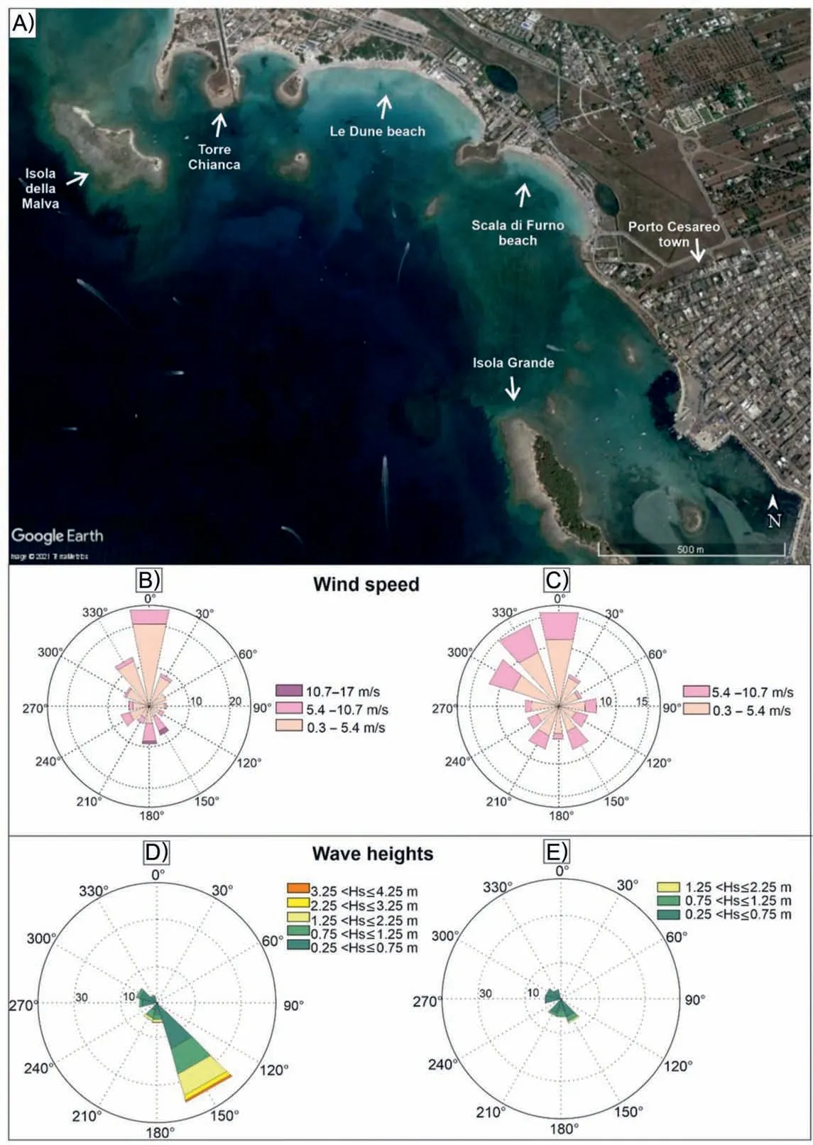
Fig.2 A)Geographical location of Le Dune beach,a typical pocket beach limited by two promontories;B)Wind directions and frequencies from Porto Cesareo;C)Taranto anemometric station(modified by Milli et al.,2017);D)Directional distribution of the significant wave heights of Taranto between 2006 and 2013 during winter season and E) summer season (modified by Petrillo et al., 2014).
Moreover, within the textural investigation, a morphometric analysis was carried out through the ImageJ software, which allows to describe the beach sediments by the use of a few shape descriptors such as aspect ratio, solidity, circularity and roundness.
3.3. Petrographic investigation and bioclast evaluation
The most frequent size class of the statistical distribution was investigated through a binocular optical microscope and the percentage of the main constituents of sands was evaluated to obtain quantitative and qualitative information in terms of petrographic composition. Since the investigation confirmed the presence of three main components, the sands were classified with the diagram proposed by Zuffa (1980,1985), including three main classes: 1) carbonate lithoclasts (carbonate extrarenite, CE); 2) carbonate bioclasts(carbonate intrarenite,CI);3)non-carbonate extrarenite (NCE).
Furthermore, the bioclast component of each sample was isolated by means of a set of tweezers from the rest and analysed in more detail. The unrecognizable bioclast fraction was separated from the whole and fragmented shells and percentages of unrecognizable bioclasts in each sample were classified into three types:0—30%,31%—60%,61%—90%.Successively,the whole and recognizable shells were divided on the base of their phylum to provide a first classification.The class and genus of the shells were also evaluated in the case of foraminifera.
4. Results
4.1. Textural features
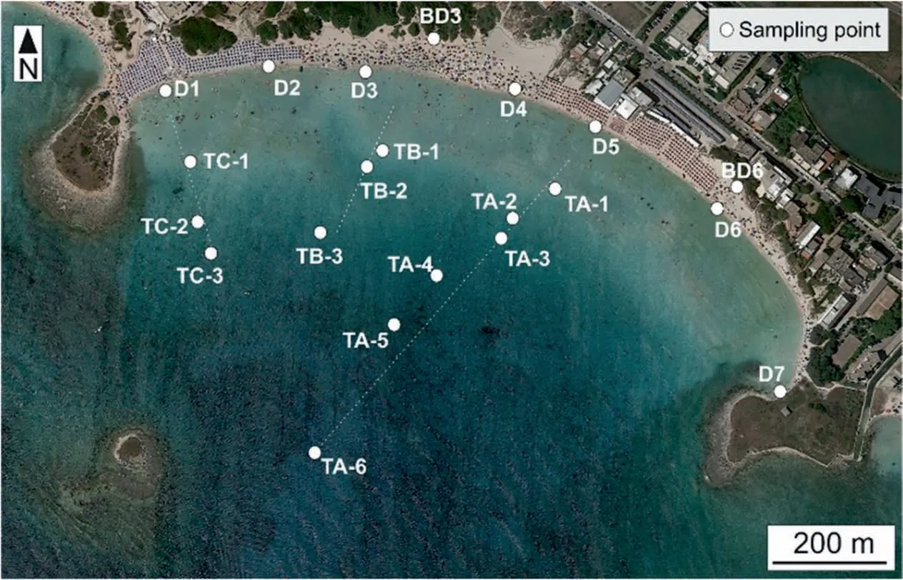
Fig. 3 Location of the sampling points at Le Dune beach. In the shoreface, the sampling points are located at each meter depth along transects TA, TB and TC. In the foreshore, samples were collected in the middle of the swash zone.

Table 1 Textural parameter variations over time along the shoreline of Le Dune beach.
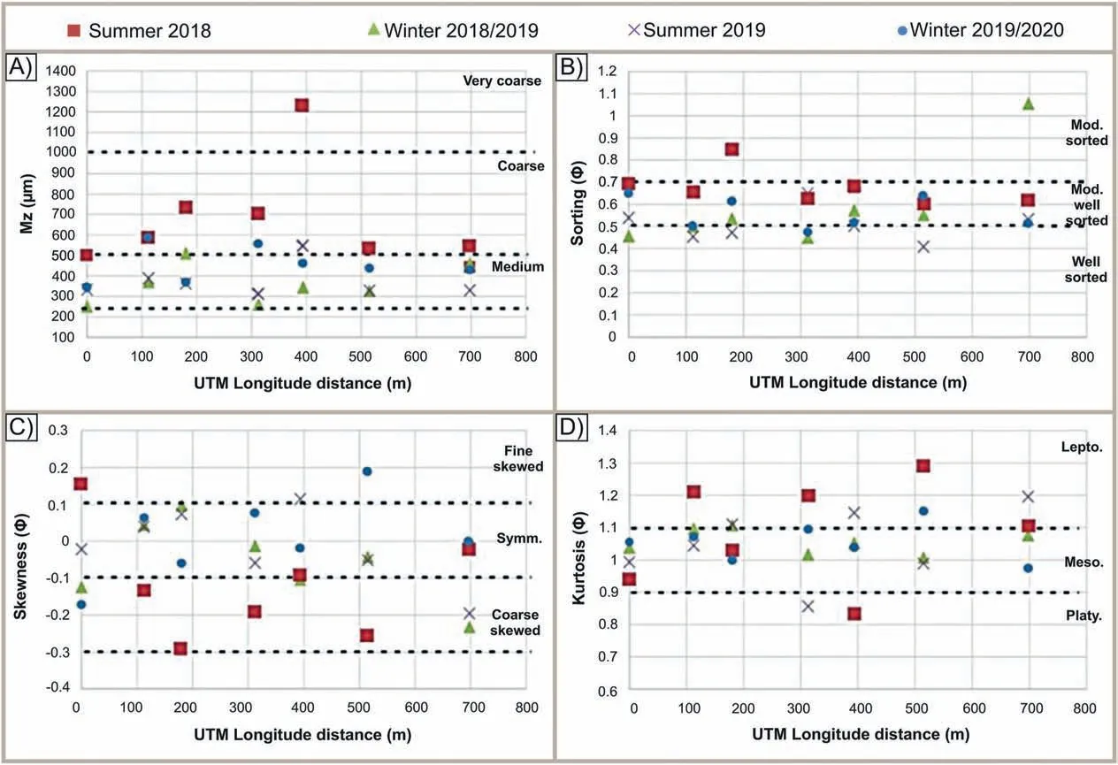
Fig. 4 Statistical parameter variations over time along the shoreline of Le Dune beach. Different granulometric parameters have been registered between summer 2018 and the following seasons. Lepto. — Leptokurtic; Meso. — Mesokurtic; Mod. — Moderately; Platy. — Platykurtic; Symm. — Symmetrical.
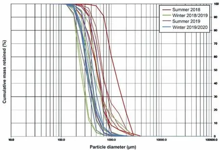
Fig. 5 Seasonal foreshore cumulative curves over time of Le Dune beach. Note the difference between summer 2018 and the following seasons.
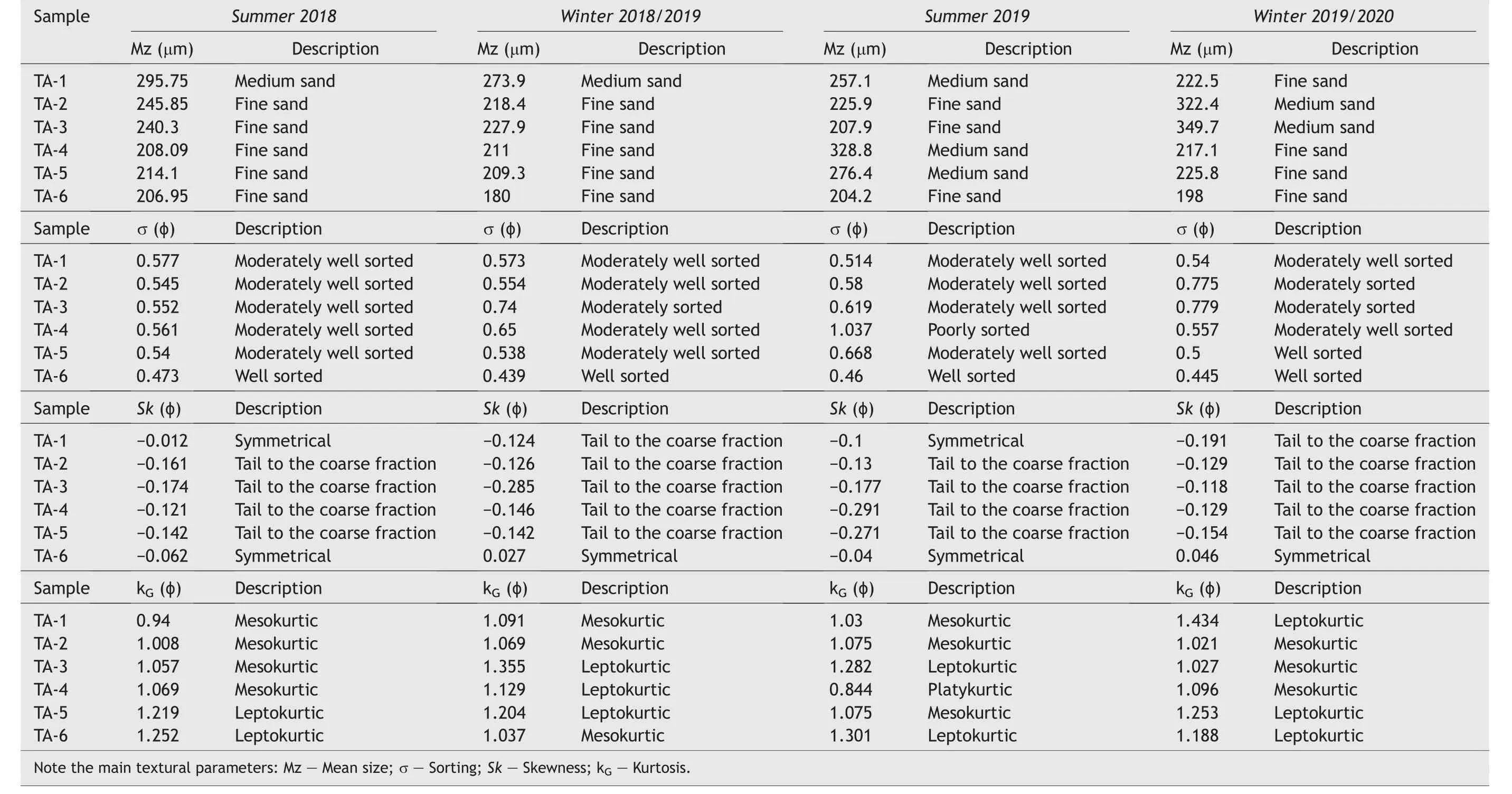
Table 2 Textural parameter variations over time along the transect A perpendicular to the coast of Le Dune beach.
Sands collected along the shoreline of Le Dune beach show different granulometric characteristics over time (Table 1). In particular, Fig. 4 underlines significant dissimilarities between summer 2018 and the following seasons. Samples collected during the first seasonal sampling have registered higher values of mean size,sorting and kurtosis and the lowest range of skewness describing the sediments as moderately wellsorted coarse sands with tails to the coarse fraction and leptokurtic curves. Samples collected in winter 2018/2019, summer 2019 and winter 2019/2020 instead are mostly characterised by well-sorted and moderately well-sorted medium sands with skewness values included between -0.1 ɸ and +0.1 ɸ (symmetrical) and mesokurtic curves.
As regards the mean size and sorting parameters,the textural differences are also highlighted by comparing the cumulative curves of the foreshore samples over time. As shown in Fig. 5, the samples collected in summer 2018 are represented by a wider granulometric range and minor slopes than those collected later.
In the shoreface, the sands are mainly characterised by moderately well-sorted medium—fine sands with coarse skewed curves and mesokurtic and leptokurtic kurtosis range (Table 2). In particular, Fig. 6 depicts a slight decreasing trend of the mean size with depth(Fig.6A),a less sorting range(Fig.6B)and coarse skewed values(Fig.6C)between 1.5 m and 3 m,and a regular increasing tendency of kurtosis with depth (Fig. 6D). Consequently, the sands range from moderately-sorted medium sands with tails to the coarse fraction and mesokurtic curves in the first meter depth, to well-sorted fine sands with symmetrical and leptokurtic curves in the deepest shoreface.
As regards the morphometric analysis, Fig. 7 depicts the predominant grain morphologies in the different sub-environments of Le Dune beach. Along the shoreline, bladed-shaped grains prevail (35%),whereas the rod/prolate grains represent the 30% of morphologies. Oblate or discoid grains at the poles show percentages equal to 21%,while those of equant or circular shape are with percentages of 14%(Fig.7).
In the submerged beach, the prevailing morphologies are slightly different. 35% grains are characterised by the discoid or oblate shape,31%grains show“blade”shape,while the sands with rod/prolate shape show percentages equal to 20%. Grains of circular or equant shape are with percentages of 14% (Fig. 7).
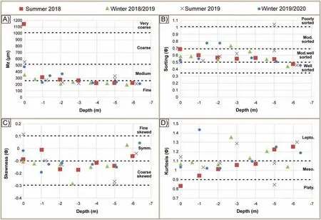
Fig.6 Over time seasonal parameter variation along the cross-shore transect A.A)Mean size variation with depth;B)Sorting variation with depth; C) Skewness variation with depth; D) Kurtosis variation with depth. Lepto. — Leptokurtic; Meso. — Mesokurtic; Mod. — Moderately;Platy. — Platykurtic; Symm. — Symmetrical.

Fig. 7 Morphologies of Le Dune beach sands represented by the use of Zingg (1935) diagram. Note that L/I describes the ratio of long/intermediate diameter, whereas s/l represents the ratio of short/long diameter.
4.2. Beach sand composition and features of the bioclast component
The classification of sands containing carbonate and siliciclastic components refers to the definition of“Hybrid sands” (sensu Zuffa, 1980) corresponding to the “miscellaneous sand” of Pettijohn (1975) and the“mixed sand” of Mount (1985).
In order to classify the Le Dune beach sands(Fig.8),the recognition of the following components is required: 1) carbonate extrarenite (CE), 2) carbonate intrarenite (CI), and 3) non-carbonate extrarenite(NCE). The petrographical results, deriving from the stereomicroscope analysis, mainly define the Le Dune sands as the “Hybrid intrabasinal sand” (sensu Zuffa,1980) characterised by high percentages of bioclasts since almost all samples fall into the field close to the vertex CI.
One of the most significant aspects of Le Dune beach regards the sand composition, which mainly includes 90% of bioclasts. Indeed, by analysing the sand at the binocular optical microscope,the samples always show high percentages of intrabasinal carbonate grains deriving from whole and fragments of carbonate shells.In this respect,Fig.9 shows the bioclast percentage variation over time within the entire beach environment. As depicted in this figure, the bioclast content increases from the dune base to the shoreface, ranging between 83% and 99%, respectively.Within the shoreface, it is registered a slight decreasing trend of the bioclast percentage (5%) between 1 m and 3 m depth.

Fig. 8 Beach sand classification according to Zuffa (1980, 1985). A) Petrographical features of Le Dune beach sands observed through an optical binocular microscope; B) Composition-based classification of Le Dune beach sands (CI — Carbonate intrarenite; CE — Carbonate extrarenite; NCE — Non-carbonate extrarenite).
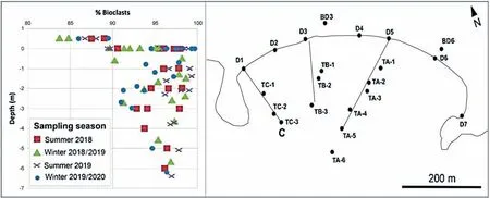
Fig.9 Location of the sampling points with the bioclast variations over time at Le Dune beach.Note that the bioclast component increases from the dune base to the shoreface.
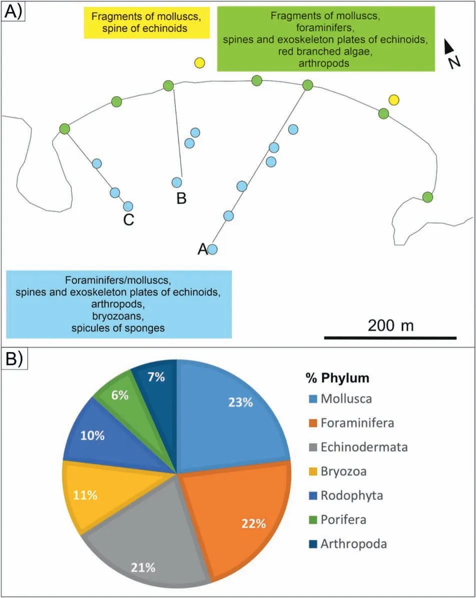
Fig. 10 A) Distribution map of bioclast component and B) Pie chart of phylum percentage registered in the samples of Le dune beach. In Fig. 10A, each color represents the location of the sampling point: yellow — dune base; green — foreshore; light blue — shoreface.
Due to the high bioclast percentage within the entire beach, Fig. 10 depicts the main phylum distribution according to the sampling point: dune base,foreshore and shoreface.By the results of the bioclast evaluation, seven main phyla are included among the samples (Fig. 10B). In particular, the bioclast component of Le Dune beach sands (Fig. 11) is mainly characterised by 23% whole or fragmented shells of molluscs (Gastropoda, Bivalvia, Polyplacophora), 22%foraminifers (in particular, the Globothalamea class characterised by Elphidium crispum, Rosalina spp.,
Ammonia spp., Globigerina spp., the Tubothalamea class including Peneroplis planatus and Peneroplis perto, Sorites spp., Quinqueloculina spp., the Rotaliata class composed of Miniacina miniacea, Bolivina spp., and the Miliolata class characterised by Spiroloculina spp.),21%spines and exoskeleton plates of echinoids,11%bryozoans,10%red branched algae,7%fragments of arthropods, and 6% spicules of sponges(Fig. 10B). The figures below (Figs. 9 and 10) also highlight a higher number of phyla in the foreshore and shoreface than in the dune base.
5. Discussion
The recognised textural and compositional variations of Le Dune beach can be attributable to its sedimentary dynamics and sediment provenance that significantly influence the pocket beach conservation.

Fig. 11 Bioclasts better preserved within Le Dune beach sands. A)Bivalvia fragments; B) Gastropoda; C) Spines of echinoids; D) Elphidium spp.;E)Peneroplis spp.;F) Foraminifers with porcelaneous shell; G)Peneroplis spp.on the left and Caecum spp.on the right;H) Miniacina miniacea; I) Algae branched; J) Arthropoda fragments; K) Spicule of sponge; L) Ostracoda spp.
As regards the textural features, beach sediments mainly consist of coarse and medium sands along the shoreline and medium to fine sands in the shoreface(Tables 1 and 2).The sediments are also characterised by well-to moderately well-sorted sands with negative/around 0 skewness values and kurtosis represented by mesokurtic and leptokurtic curves. By recording the statistical parameter variations over time and the cumulative curves of the foreshore samples(Figs.4 and 5),Le Dune beach is characterised by a more stable condition in summer 2018 than the following seasons as the texture of the samples is described as less-sorted coarser sands exclusively in the first sampling campaign.Indeed,samples collected in summer 2018 are represented by a wider granulometric range and minor slopes than those collected later. This consideration, coupled with more negative skewness values in summer 2018,results in a foreshore stable condition in summer 2018 and a steady erosional trend in the following seasons.Moreover,in almost all seasons, there is a general increasing mean size and decreasing sorting trend from the lateral headlands to the central portion of the beach. This granulometric tendency could be linked to the presence of a longshore transport that leaves the coarser sediment in the central part of the coast, carrying the finer one towards the headlands.
Within the shoreface (Fig. 6), samples are characterised by a slight decreasing trend of the mean size with depth, a less sorting range and coarse skewed values between 1.5 m and 3 m.In addition,at the same depths,the bioclast percentage variation registered a slight decreasing trend of the bioclast component(5%),suggesting the presence of frequent high-energy events that continuously select the sediments between 1 m and 3 m depths, where wave breaking occurs.
The carbonate component (mainly bioclasts) represents the predominant element included within Le Dune beach sands (Fig. 8). In particular, sands collected along the dune base are composed of fragments of molluscs and spines of echinoids, whereas the foreshore and the shoreface are characterised by the same phyla(molluscs and echinoids)coupled with foraminifers, red branched algae, arthropods, bryozoans and spicules sponges (Fig. 10). In this respect,the morphometric investigation underlines the presence of different morphologies strictly correlated to the distribution of the different phylum within the beach environment. The shoreline prevails bladed and prolate morphologies as the foreshore is mainly characterised by molluscs and spines of echinoids,whereas the shoreface is almost represented by oblate and bladed morphologies as foraminifers,bryozoans and spicule of sponges represent the most abundant phylum (Figs. 7 and 10). In particular, the oblate morphology can be related to the presence of a large quantity of Peneroplis spp. that represents the predominant foraminifer occurring within the shoreface.

Fig. 12 Sediment dispersal scheme of the Le Dune beach along a coastal sector of the Apulia Ionian Sea.
Furthermore, by taking into account the bioclast qualitative investigation,most of the carbonate shells are mainly associated with Posidonia oceanica such as benthic foraminifers,particularly Miniacina miniacea,the gastropod Caecum spp.,red branched algae,other molluscs, bryozoans and spicules of sponges (Fig. 11).This result suggests that parts of the bioclastic sands derive from the seagrass meadows located offshore of the study coast.
Considering the southerly seas as the main wave direction, Fig. 12 shows the final sediment dispersal scheme occurring within the bay.The scheme intends to represent the semi-closed coastal system of Le Dune beach in which sediment inputs derive from local sources and sediment outputs involve small amounts of sediments.As shown in Fig.12,the main sediment input derives from the erosion of the dunes,rocky shoreface and lateral headlands coupled with the bioclastic sediment supply from the offshore. Therefore, the sedimentary dynamics is controlled by a predominant accretion of sand diffusion by aeolian processes,especially in the westernmost part of the coast; a crossshore sediment transport; a nearshore rip circulation characterised by a longshore sediment transport converging in the middle of the embayment; a weak lateral sediment interchange with adjacent littoral sectors and an offshore sand dispersion during storm events.The current morphological configuration of the sea bottom significantly influences the cross-shore sediment transport,as the rocky headlands located in the shallow water and the rocky sea bottom make the beach an almost completely closed bay, which is also characterised by the absence of river basins and the presence of strong rip currents that carry large amounts of sediments towards the offshore during storm events.
6. Conclusions
Le Dune is a carbonate bioclastic pocket beach lying on a coastal sector of the Ionian Sea, southern Italy. The beach is limited by two promontories and the sediment transport mainly takes place within the bay itself. The beach sedimentary dynamics are significantly influenced by a nearshore rip circulation and by the zeta-form shorelines established in response to the oblique direction of the incoming southern seas.
The dune is partially preserved in the western part of the coast where it is vegetated, while the central and eastern sector of the beach is characterised by the presence of an urbanized area that causes the almost complete absence and a low preservation of the dune environment with the sand loss towards inland.
The peculiarities of the beach dynamics found out in this study and the increasingly developed anthropogenic pressure on the Ionian littoral stretch highlight the significant vulnerability of Le Dune beach to coastal erosion as almost all the material available is confined to the bay itself.
The investigated coastal system could be considered as unnourished and in the fossil sedimentary successions it could be recognizable mainly by coarse to fine bioclastic sediments with a significant lateral variability of the facies, and a very low preservation potential in the geological records.
Moreover, the beach sand analysis, including textural, compositional and bioclast investigations underlines that one of the main indicators of the beach dynamics is the bioclast component, which provides relevant information about sand provenance and sediment transport.
These results are strictly correlated with a 2-year beach monitoring that is only able to evaluate sudden and small-scale beach variations. However, the sediment provenance analysis underlines the existence of many beaches that are preserved mainly thanks to the bioclast production and the presence of a developed dune environment. Indeed, the evolution of these beaches is strictly related to the health state of the carbonate factory area(mainly the adjacent seagrass)and the sediment included within the dunes. Therefore, Le Dune beach needs the protection of the seagrass by inhibiting intensive fishing actions,anchoring,nourishment activities,etc.,and the restoration of the dune bodies in the most anthropogenic zones.
Finally,the qualitative and quantitative changes of the bioclastic content along and cross shore result in problematic stratigraphic correlations between adjacent logs in fossil successions located in similar settings. For the same reasons, the bioclastic content should be analysed in terms of lateral comparisons to obtain reliable palaeoenvironmental and palaeogeographic reconstructions.
List of abbreviations
CE Carbonate extrarenite
CI Carbonate intrarenite
L/I The ratio of long/intermediate diameter
Lepto Leptokurtic
Meso Mesokurtic
Mod Moderately
NCE Non-carbonate extrarenite
NCI Non-carbonate intrarenite
Platy Platykurtic
s/l The ratio of short/long diameter
Symm Symmetrical
Funding
We declare that the data reported in this study were obtained with the research financed by European Funding “Ricerca e Innovazione 2014—2020 (PON RI 2014—2020)” .
Availability of data and materials
All data and materials generated or analysed during this study are included in this published paper.
Authors' contributions
All the authors have actively participated in the preparation of the manuscript. Lapietra, I., Moretti,M., and Lisco, S. conceived the study. Sampling procedures have been carried out by Lapietra, I. and Lisco, S. Sedimentological analyses have been conducted and interpreted by Lapietra, I., Lisco, S., Rossini,B.,Moretti,M.,and Milli,S.Petrographic analyses and bioclast evaluation have been carried out by Lapietra, I. and Lisco, S. Moretti, M. has realized the geological framing of the area. The integration of sedimentological, petrographic and ecological data has been carried out by Lapietra, I. Milli, S. contributed to the critical revision of the paper. All authors read and approved the final proof.
Conflicts of interest
There are no conflicting interests between the authors and institutions involved.
Acknowledgements
The authors thank Prof. Zeng-Zhao Feng, Prof. Ian D.Somerville,Prof.Santanu Banerjee,Ms.Yuan Wang,and two anonymous reviewers for comments that greatly improved the manuscript.
杂志排行
Journal of Palaeogeography的其它文章
- The primary dolostone in the Meso-Neoproterozoic: Cases study on platforms in China
- Tracking sources and paleotectonic settings of Mesozoic sandstones in interlinked rift basins of western India: An integrated approach using petrography and heavy mineral chemistry
- Initiation and evolution of coarse-grained deposits in the Late Quaternary Lake Chenghai source-to-sink system: From subaqueous colluvial apron (subaqueous fans) to Gilberttype delta
- Detrital zircon ages of Oligocene to Miocene sandstone suites of the Southern Apennines foreland basin system, Italy
- Provenance studies on the heavy mineral placers along the coastal deposits of Odisha,eastern India
- Basin-filling processes and hydrocarbon source rock prediction of low-exploration degree areas in rift lacustrine basins: a case from the Wenchang Formation in low-exploration degree areas, northern Zhu I Depression, Pearl River Mouth Basin, E China
