Initiation and evolution of coarse-grained deposits in the Late Quaternary Lake Chenghai source-to-sink system: From subaqueous colluvial apron (subaqueous fans) to Gilberttype delta
2022-06-10DoToDongLongWeiQiuPengJieGuoDingYuYuZheWngShiBoZhouBoLingYngHeQingHungYongQingYngXinLi
Do-To Dong , Long-Wei Qiu ,*, Peng-Jie M , Guo-Ding Yu ,Yu-Zhe Wng , Shi-Bo Zhou , Bo-Ling Yng ,He-Qing Hung , Yong-Qing Yng , Xin Li
a School of Geosciences, China University of Petroleum (East China), Qingdao 266580, Shandong Province,China
b SINOPEC Geophysical Research Institute, Nanjing 211103, Jiangsu Province, China
c CCCC Second Highway Consultants Co. Ltd., Wuhan 430056, Hubei Province, China
Abstract Investigating the formation and evolution of coarse-grained deposits in modern lakes and the relevant controlling conditions is indispensable to the prediction of reservoir sandbodies, disaster prediction,and limnological research. The source-to-sink system of coarse-grained deposits in Lake Chenghai, a deep,scarped Late Quaternary lake, was investigated in this study based on 62 outcrops, Advanced Land Observing Satellite (ALOS) digital elevation model (DEM) data, and regional geological survey data. The findings include the following: (1) the source areas of coarse-grained deposits in Lake Chenghai were lithologically classified into carbonate source areas, basaltic source areas and siliciclastic source areas, and were geomorphically categorized as scarp type or confluence type. Subaqueous colluvial aprons have formed downstream of the carbonate source areas and scarp-type basaltic source areas, while Gilbert-type deltas have formed downstream of siliciclastic source areas and confluence-type basaltic source areas.(2)The formation and evolution of coarse-grained deposits are controlled by the sediment flux that evolves in synchrony with the geomorphic evolution of the source areas and the sink regimes. Scarps represent the initial landform of the source areas.Source material rolls off or slides down scarps or forms small-scale debris flows before entering the lake.The source material initially formed subaqueous colluvial apron (synonymous with subaqueous fans) where sufficient space was present to accommodate sediments and the basement angle exceeded than the natural angle of repose.As weathering and denudation have progressed,the initial scarps have transformed into confluencetype slopes, and the source material has formed medium- and large-scale debris flows that have entered the lake, resulting in an increase in sediment flux. Consequently, the subaqueous colluvial aprons have rapidly grown and developed subaerial deposits,which have evolved into larger-scale Gilbert-type deltas that overlie the initial aprons. (3) The morphology and distribution of coarse-grained deposits vary in response to differences in quantity and composition of materials from different source areas, which resulting from different rates of weathering and denudation and different sediment input regimes. Firstly, the size and surface slope angle of a subaqueous colluvial apron from a carbonate source are smaller than those of a subaqueous colluvial apron of basaltic origin. Secondly, a Gilbert-type delta from a basaltic source features a greater slope angle and a thicker topset than does a Gilbert-type delta of siliciclastic origin, and the latter exhibits a longer foreset and a thicker bottomset than in the former. Thirdly, the sizes of subaqueous colluvial aprons are not strongly correlated with the sizes of the source areas, while the sizes of Gilbert-type deltas are.
Keywords Coarse-grained deposits, Gilbert-type delta, Subaqueous colluvial apron, Subaqueous fans,Source-to-sink, Weathering and denudation, Sediment input regime, Lake Chenghai, Quaternary
1. Introduction
Coarse-grained deposits, such as subaqueous alluvial fans(Sun et al.,1980),nearshore subaqueous fans(Zhang and Tian, 1999; Cao et al., 2018), subaqueous fans(Zhang et al.,2019),fan deltas(McPherson et al.,1987), and Gilbert-type deltas (Smith and Jol, 1997;Longhitano, 2008), are widely distributed in recent and ancient lakes (Sun et al., 1980; Bell, 2008), high latitudes fjords (Parsons et al., 2014; Stacey and Hill,2016), and mountain reservoirs setting (Thomas,1954; Schleiss et al., 2016). Because of their instability, these deposits may collapse, causing tsunamis(Parsons et al.,2014),lake tsunamis(Mountjoy et al.,2019;Strupler et al.,2019),or reservoir sedimentation(Thomas, 1954; Lai and Capart, 2009; Schleiss et al.,2016). The coarse-grained deposits in the strata are hydrocarbon reservoirs with extremely-high economic value (Sun et al., 1980; Zhang and Tian, 1999; Cao et al.,2018).
Research on coarse-grained deposits that have formed in stable water bodies has achieved fruitful results in the past 140 years or so, since the first geological survey conducted by Gilbert in 1885 on the nearshore coarse-grained delta of Quaternary Lake Bonneville (Gilbert, 1885). The results have mainly focused on the following three aspects: (1) definition of coarse-grained deposits based on lithofacies, sequences,sedimentary architecture,and facies models(McPherson et al., 1987; Nemec, 1990; Xue and Galloway, 1991; Zhang and Tian, 1999; McConnico and Bassett, 2007; Blair and McPherson, 2008;Longhitano, 2008; Backert et al., 2010; Gobo et al.,2014; Eide et al., 2016; Cao et al., 2018; Chiarella et al., 2021); (2) determination of the fluid dynamics involved in the formation and development of coarsegrained deposits using new techniques, e.g., using sonar to obtain a high-resolution subaqueous digital elevation model (DEM) for the direct observation of bedforms(Stacey and Hill,2016;Strupler et al.,2019)and using flume experiments and numerical simulation experiments to reconstruct the hydrodynamic process of load transporting and unloading (Nemec, 1990;Kostic and Parker,2003a,2003b;Lai and Capart,2007,2009; Van Dijk et al., 2009; Ferrer-Boix et al., 2015;Gobo et al., 2015; Lai et al., 2017); and (3) exploring the conditions that lead to the formation and development of coarse-grained deposits,which is the focus of this paper.
China has the most deep and steep rift basins all over the world. A large oil reservoir can often be discovered in the coarse-grained sandbodies, which distribute along the subaqueous scarp slopes of deep and scarped lacustrine basins, such as the Triassic Junggar Basin (Tan et al., 2017), the Cretaceous Luanping Basin (Bai et al., 2020; Yang et al., 2021),the Eocene Gaoyou Depression of Subei Basin (Yuan et al., 2016), and the Eocene Dongying (Cao et al.,2018; Zhu et al., 2018; Zhang et al., 2019) and Shulu depressions (Kong et al., 2019) of Bohai Bay Basin. In general, two key problems limited the exploration and development of oil reservoir in these deep-water coarse-grained sandbodies: (1) the processes of formation and development of coarsegrained deposits, and (2) the relevant main controlling factors (Zhang et al., 2019).
On the worldwide scope, most relevant studies involve one or more controlling factors, of which the most frequently mentioned are the activity of boundary faults(Colella,1988;Young et al.,2000;Cao et al.,2018;Ma et al.,2021)and regional tectonic uplift and subsidence (Sømme and Jackson, 2013; Pechlivanidou et al., 2018, 2019), followed by the basin regime(Catuneanu et al., 2002) and the source area size(Sømme and Jackson,2013;Pechlivanidou et al.,2018;Liu et al., 2019).
Elliott (1986) proposed that the formation and development of a delta is a complex process that is controlled by climate, tectonics, subsidence, fluvial regime and sediment loads,and basin morphology and size. This concept was immediately introduced by Postma (1990) into research on coarse-grained deposits.Allen(2008)and Liu et al.(2019)advocated the use of the “source-to-sink” system to systematically understand the mechanisms driving surface processes and sediment routing systems,solidifying the concept proposed by Elliott (1986). Along with advances in research methods, investigation of the weathering of the parent rock, the sediment flux, and the sediment input regime based on the “source-to-sink” system is an important approach for elucidating the formation and development of coarse-grained deposits (a complex system)and their relevant controlling conditions.Henstra et al.(2016)believed that the evolution of the landform in the source region from scarps to low and gentle slopes under specific tectonic and climatic conditions drove the evolution of the Mesozoic coarsegrained rift-margin turbidite system in East Greenland.However, Henstra et al. (2016) selected modern Lake Baikal as the source region,which does not intuitively reflect the complete process from source to sink.
The source-to-sink system of Lake Chenghai, a deep scarp-bounded Late Quaternary lake, features special geological conditions in the source areas that make it convenient to set up controlled experiments,and the Late Quaternary coarse-grained deposits in its sink regions are completely exposed because of the large drop of the lake water level,making the system perfect for studying the formation and evolution of coarse-grained deposits.
Therefore,we conducted a systematic survey based on fieldwork,Advanced Land Observing Satellite(ALOS)digital elevation model (DEM) data, and regional geological survey results, to obtain a large quantity of geological and geomorphic data on the source and sink regions. Furthermore, geomorphic evolution in the source areas and the temporal and spatial differences in the resultant sediment generation, sediment flux,and sediment input regimes were assessed based on the rates of weathering and denudation, and their causal relationships with the various coarse-grained deposits in the sink regions were explored.Finally,models of the formation and evolution of coarse-grained deposits and the mechanisms of the relevant controlling conditions were obtained.The data and models in this study can be used directly to predict the dynamics of lacustrine sandbodies and hydrocarbon reservoirs as well as indirectly to monitor and predict lake tsunamis and to investigate the local history of tectonics and climate by examining lake sediments.
2. Geological setting
Lake Chenghai is a long (south—north), narrow,deep and scarped lake in the Hengduan Mountains in northwestern Yunnan Province, China. It has a drainage area of 340.9 km2,a surface area of 73.5 km2,a mean water depth of 26.5 m,and a maximum water depth of over 35 m(Sun et al.,2017;Hu et al.,2020).It is located on the southeastern margin of the Qinghai—Tibet Plateau, within the northern Chenghai fault zone at the northern boundary of the Red River fault zone (Fig. 1A) (Lee and Jin, 1990; Wang, 1998).
Since the Late Quaternary, the Lake Chenghai watershed has been tectonically active,and the activity rates of basin-controlling faults on its eastern and western shores range from approximately 3.1—4.0 mm/y (Lee and Jin, 1990), resulting in the geomorphic characteristic of high relief(maximum relief exceeding 1900m)inthesourceareas(Fig.2A,B).Themeanannual temperature, mean annual rainfall, and mean annual evaporation inthe LakeChenghaiwatershed are 17.6°C,705 mm,and 1602 mm,respectively(Chen et al.,2019).It is a dry valley in a warm temperate climate(Fig.1G)(Kotteketal.,2006).Thetemperature andrainfallinthe Lake Chenghai watershed through most of the Holocene were significantly higher than the current levels(Fig.1C—F).The historical lake level of Lake Chenghai was stable for a long time at 1542 m(Ji,2014),and its surface area, mean water depth, and maximum water depth were 90.7 km2, approximately 70 m, and approximately 80 m,respectively.
The coarse-grained deposits were mainly formed in this highstand system tract,when the lake water overflowed to the south and merged into the Jinsha River through the ancient Cheng River.As the climate became warm and dry,the lake level of Lake Chenghai dropped continuously. It has been an endorheic lake since 1573(Ji, 2014). The measured lake-level elevation in December 2019 was 1489 m.Under this low lake level,most of the subaqueous colluvial aprons and Gilberttype deltas formed in the highstand system were subaerially exposed (Fig. 2C), and only some of the bottomsets and all deep-lacustrine deposits remained underwater.

Fig. 1 Overview of the geology and geomorphology of the Lake Chenghai watershed. A) Distribution of tectonic structures in the Lake Chenghai region,modified from Wang(1998)and Tapponnier et al.(2001);B)Local geological characteristics of Lake Chenghai,modified from Lee and Jin (1990); C) Characteristics of oxygen isotope variation in the Holocene revealed by nearshore stalagmites of Lake Lugu, 120 km north of Lake Chenghai,modified from Lin et al.(2001);D)Characteristics of carbon isotope variation in the Holocene revealed by boreholes in the centre of Lake Chenghai,modified from Sun et al.(2017);E)Characteristics of the variation in median grain size revealed by boreholes in the centre of Lake Lugu,modified from Shen et al.(2015);F)Characteristics of C/N ratio variation revealed by boreholes in the centre of Lake Lugu,modified from Shen et al.(2015);G)Annual temperature,rainfall,and evaporation in the Lake Chenghai watershed,modified from Chen et al. (2019).
The source areas on the western shore of Lake Chenghai are entirely composed of Permian basalts,which is part of the Emeishan large igneous province(Xu et al.,2004).The source areas on the northeastern shore are composed of Paleozoic carbonate rocks.The source areas on the southeastern shore consist of Jurassic clastic rocks interbedded with sandstones and mudstones (Lee and Jin, 1990) (Fig. 1B). The north-—south-trending strata of the source areas of Lake Chenghai form dip slopes (it means the underlying strata are inclined in the same direction as the natural slope) on the eastern shore, and anti-dip slopes (it means the underlying strata are inclined in the reverse direction as the natural slope)on the western shore for its dipping westwards.
3. Data and methods
3.1. Fieldwork
This study involved fifteen days of fieldwork around the Lake Chenghai, Hengduan Mountains. 62 outcrops(Fig.2C)through source and sink areas were renovated and investigated.15 detailed sedimentary logs(green dots in Fig. 2C) were made through 2 subaqueous colluvial aprons and 4 Gilbert-type deltas around the Lake Chenghai. For each sedimentary log, the bed thickness, elevation, grain size, sedimentary structures, and facies succession were documented. The locations (WGS-84) of real scene shootings, sedimentary logs(or facies successions)are listed in the List of locations at the end of text.
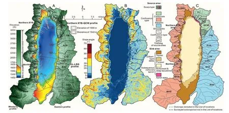
Fig. 2 Subaerial and subaqueous DEM (A), slope angle DEM (B), and the partition plan of the source-to-sink system of Lake Chenghai (C).
3.2. The source areas
The source areas of Lake Chenghai were divided into 48 blocks based on field reconnaissance and whether they independently supply Lake Chenghai with source materials and produce independent deposits(Fig.2A,B).DEM(revealed by ALOS PALSAR RTC High Res ALPSRP159230520 and ALPSRP159230510)was used to characterize the geomorphic parameters of the source areas,such as their surface area,length of thalweg (Fig. 2C), slope angle distribution(Fig. 2B), and elevation difference (Fig. 2A). The surface area and length of thalweg were measured with Google Earth,and the slope angle,elevation and elevation difference were measured with Global Mapper. The most representative parameters were chosen from a huge number of raw measurements and then shown in Table 1. Stratigraphic occurrence and parent rock distribution in the source areas,as well as sediment generation and transport and the sediment input regime, were determined from regional geological survey data (Heqing (G-47-17) 1:200,000 geological map of the People's Republic of China) and fieldwork.
3.3. Discrepancy of weathering and denudation rates
The annual total sediment flux from Taiwan rivers is approximately equal to the sum of Changjiang River and Yellow River,and the αBa value(one of weathering indices) of fluvial sediments from Taiwan rivers is significantly lower than that of fluvial sediments from Changjiang River and rivers in Zhejiang and Fujian Province at the same time (Bi et al., 2015; Li et al.,2016). It indicates that the strong tectonics and climate impacts (monsoon and typhoon etc.) dominated the highest rates of weathering and denudation of small mountain rivers (SMRs) in Taiwan Island.Because of the very short residence time of SMRs source-to-sink system, the degree of chemical weathering of fluvial sediments of SMRs is significantly lower than the degree of physical weathering (Bi et al., 2015; Li et al., 2016). Therefore, the analysis of rates of weathering and denudation of this paper placed an emphasis on physical weathering and denudation.
For Lake Chenghai watershed, the dramatic uplift and subsidence since the Late Quaternary(Lee and Jin,1990)is the premise of the formation of high and steep mountains, deep lakes and large slopes. The differences in lithology and occurrence among carbonate,basaltic, and siliciclastic source areas (Fig. 1B) have led to different rates of weathering and denudation,resulting in temporal and spatial differences in geomorphic evolution among the three.
Therefore, the discrepancy of weathering and denudation rates in source areas were comprehensively assessed and interpreted based on two evaluation criterions, namely the coefficients of thermal expansion of rocks(Mindess et al.,2003)and the rock porosity-based weathering potential index (WPI)(Singh et al., 1987), and the specific distribution of lithology which including the occurrence in the source areas (Kirkby, 1985; Cao, 1995; Huggett, 2011). The values or standards of two evaluation criterions are described in detail by Singh et al. (1987) and Mindess et al. (2003).
3.4. The sink areas
The sink areas were divided into 48 pieces(Fig. 2C) corresponding to the delineation of source areas with the standard lake level at 1542 m. The highest elevation and length (or radius)of the topset,the highest elevation of the foreset, the angle of the topset, the length and angle of the foreset, and the angle of the bottomset were measured to characterize the morphology of each Gilbert-type delta.The length,angle,and highest elevation of the apron apex and the angle of the bottomset were measured to characterize each subaqueous colluvial apron (synonymous with subaqueous fans) (Fig. 3B). The parameters of landforms with elevations above 1500 m,i.e., the complete apron apex of each subaqueous colluvial apron and the topset and foreset of each Gilbert-type delta, were obtained from the ALOS DEM. The parameters of landforms with elevations below 1500 m, mainly including bottomsets and(semi)deep-lacustrine deposits, were obtained from low-resolution bathymetric data (Chen et al., 2019;Hu et al.,2020).Due to the gradient contact between the bottomset and the deep-lacustrine deposit, the length of the bottomset could not be measured, and only the angle of the bottomset was measured(Fig. 3B). Therefore, the size of each Gilbert-type delta is represented by the sum of length of topset and foreset,and the size of each subaqueous colluvial apron is represented by the length of apron apex.The length, slope angle, elevation and elevation difference of coarse-grained deposits were measured with Global Mapper and the most representative parameters were chosen from raw measurements and then shown in Table 1.
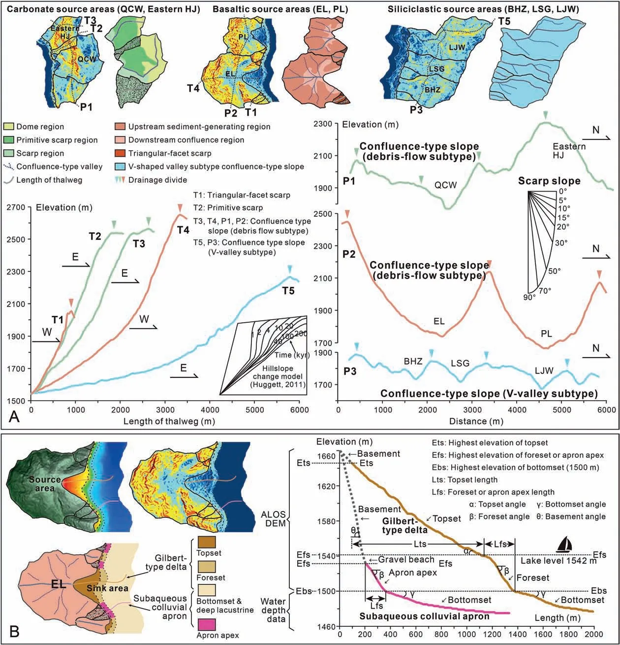
Fig.3 Definition,geomorphic parameters and the relevant measurement scheme of the source-to-sink system of Lake Chenghai.A)The DEM models and profiles along the thalweg (T1, T2, T3, T4, T5) and perpendicular to thalweg (P1, P2, P3) show the discrepancy of landforms between carbonate,basaltic and siliciclastic source areas;B)Definition of geomorphic parameters and the relevant measurement scheme of subaqueous colluvial apron and Gilbert-type delta.
4. Results
4.1. Features of denudational landforms in the source areas
According to the geomorphic characteristics, the source areas of Lake Chenghai were categorized into two types: the scarp type and the confluence type.The slope angles of the scarps are greater than 25°,and no confluence-type valley has developed.Comparatively,each confluence-slope is composed of an upstream sediment-generating region with a slope angle exceed 25°and a downstream confluence region with a slope angle no more than 25°, with the upstream and downstream regions connected by a confluence-type valley (Figs. 2, 3A).

Table 1 Original geomorphic parameters of the source-to-sink system of Lake Chenghai.

Table 1 — (continued)
The 17 scarp-type source areas account for 3.3%of the total area of the source areas. The five primitive scarps in the carbonate source areas are large,with an average area of 724×103m2and an average length of thalweg of 951 m. The 12 residual scarps are distributed in the basaltic and siliciclastic source areas, and the 11 nearshore triangular-facet scarps of basaltic source areas are small, with an average area of 104×103m2and an average length of thalweg of 369 m(Tables 1,2; Figs. 2, 3A, 4A—C, E,G).
The 31 confluence-type source areas accounted for 96.7% of the total area of the source areas.Confluence-type slopes in basaltic and carbonate source areas are composed of an upstream sedimentgenerating region with a slope angle of 30°—65°and a downstream confluence region with a slope angle of 15°—25°;and the drainage divides are high and steep,with the maximum elevation difference often exceeding 1500 m. In other words, these slopes are highly analogous to classical debris-flow catchment.Therefore,the confluence-type slopes in basaltic and carbonate source areas are termed as debris-flow subtype of confluence-type slopes. The average length of thalweg and area are 2250 m and 3068×103m2in the confluence-type carbonate source areas,and are 1980 m and 6189 ×103m2in the confluencetype basaltic source areas, respectively (Table 2;Fig. 3A).
The confluence-type slopes in siliciclastic source areas are composed of long V-shaped valleys and gentle sediment-generating region, with an average length of thalweg of 3610 m; the maximum elevation difference is generally below 1000 m;the slope angle at each side of a valley (the sediment-generating region) ranges from 5°to 25°; and the drainage divides are low and gentle(Tables 1,2;Figs.2,3A,4A—H).To distinguish from the debris-flow subtype of confluence-type slopes,the confluence-type slopes in siliciclastic source areas are termed as V-shaped valley subtype of confluence-type slopes.
Each of the 48 source areas in the source-to-sink system of Lake Chenghai has a unitary lithology; i.e.,each source region is either carbonate, basaltic, or siliciclastic. The confluence-type slopes in the carbonate source areas are often separated by large areas of scarps.The debris-flow subtype of confluence-type slopes in the basaltic source areas are adjacent to each other, and small triangular-facet scarps are distributed in the nearshore region. The siliciclastic source areas are composed of adjacent V-shaped valley subtype of confluence-type slopes. Only one triangular-facet scarp was identified in the nearshore area because of the low and gentle drainage divide(Table 1; Figs. 1B, 2C).
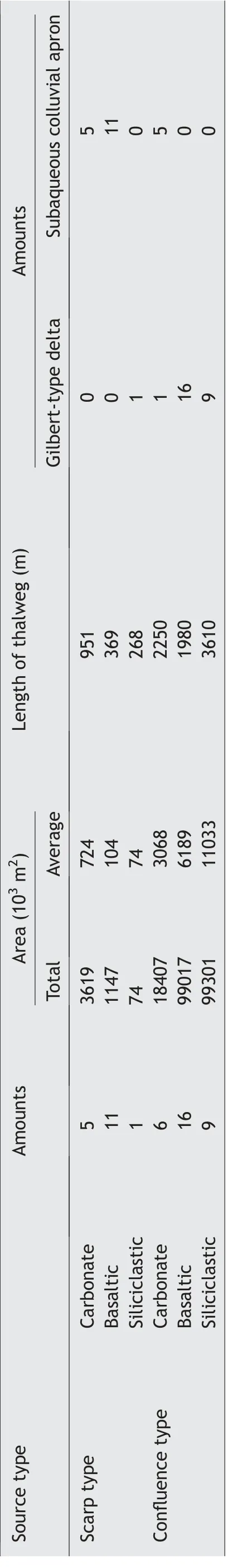
Table 2 Geomorphic parameters of the source areas of Lake Chenghai.
The surfaces of the source areas where the slope angle exceeds 40°are mostly bare bedrock, where source material tends to roll or slide downslope(Figs.2A—B,4A,I).The surfaces of source areas with slope angles of 35—40°are covered by slope wash or soil, which easily slips and flows to form debris flows(Figs. 2A—B, 4C—F, J—K). The surfaces of source areas with slope angles below 25°are subjected to stronger fluviation(Figs.2A—B,4C—F,L).In addition,only certain valleys in the source areas of Gilberttype deltas were developed along the faults, and all other valleys were formed by running water eroding bedrock (Figs. 1B, 2A—B).
4.2. Analysis of the discrepancy of
weathering and denudation rates among the source areas
High coefficients of thermal expansion of rocks can greatly accelerate weathering.The thermal expansion coefficients of siliciclastic rocks (11—12) are larger than those of carbonate rocks (6) and basalts (6—8)(Mindess et al., 2003) (Table 3). High rock porosity increases the area of contact between water and rock and thus accelerates weathering.
The WPI values of sandstones are higher than those of mudstones, and the latter values exceed those of basalts(Singh et al.,1987),suggesting that carbonate rocks have the lowest WPI values due to low porosity and permeability (Table 3). An anti-dip slope is more stable than a dip slope, and homogeneous beds are more stable than sandstone and mudstone interbeds.Poor slope stability can accelerate weathering (Cao,1995; Huggett, 2011). The basaltic source areas are anti-dip slopes, and the carbonate and siliciclastic source areas are dip slopes (Table 3; Fig. 1B). The basaltic and carbonate source areas are relatively homogeneous,and sandstone and mudstone interbeds are common in the siliciclastic source areas (Table 3;Figs. 1B, 2A—B).
In conclusion, the rates of weathering and denudation are relatively low in the carbonate source areas, where the landforms are relatively primitive;are intermediate in the basaltic source areas, where the landforms are relatively mature;and are relatively high in the siliciclastic source areas, where the landforms are most mature. Namely, the discrepancy of weathering and denudation rates dominates the increase of maturity of landforms from carbonate source areas to basaltic source areas then to siliciclastic source areas (Table 3; Fig. 3A) (Kirkby, 1985; Cao,1995; Huggett, 2011).

Fig.4 Geomorphic features of source areas of Lake Chenghai and the sediment input regimes.A)Scarps in carbonate source areas in QCW;B) DEM of scarps in carbonate source areas in QCW; C) Basaltic source areas on the western shore of Lake Chenghai; D) Carbonate and siliciclastic source areas on the eastern shore of Lake Chenghai;E)Residual triangular-facet scarps and debris-flow subtype of confluence-type slopes in EL);F)V-shaped valley subtype of confluence-type slopes in BHZ and RSH);G)DEM of residual triangular-facet scarps and V-shaped valley subtype of confluence-type slopes in EL); H) DEM of V-shaped valley subtype of confluence-type slopes in BHZ and RSH); I) Source materials rolling off and sliding down scarps in source areas in QCW;J)Collapse of a slope wash in Northern BYS,1588 m;K)Debris flow traces in PM, 1549 m; L) Seasonal stream in BHZ, 1505 m. The locations of source area are shown in Fig. 2A and C.

Table 3 Discrepancy of weathering and denudation rates and its control on maturity of landforms among the source areas.The values of coeffciients of thermal expansion of rocks are based on Mindess et al.(2003), and the standards of weathering potential index (WPI) are based on Singh et al. (1987).
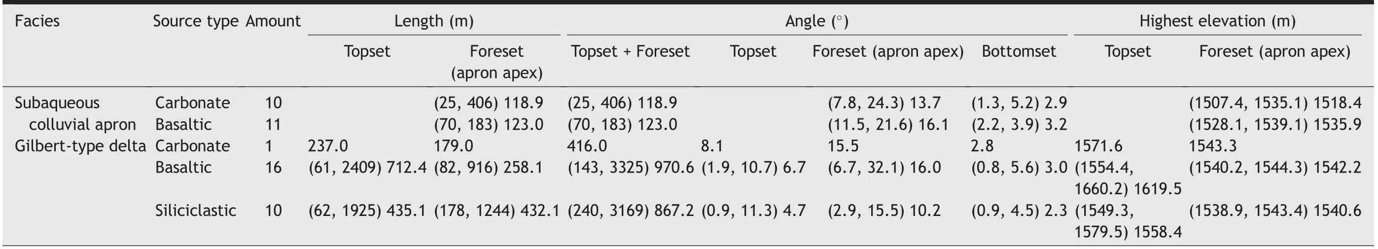
Table 4 Geomorphic parameters of the sink areas of Lake Chenghai.Note: the three values in a set refer to the minimum,the maximum, and the average,respectively.
4.3. Features of sedimentary landforms in sink areas
A subaqueous colluvial apron refers to a complexus of numbers of simultaneous, similar-shaped and similar-sized subaqueous fans, formed by sediment accumulation along the bottom of subaqueous scarp slopes. It consists of a steeply-inclined apron apex passing distal-dip into a subhorizontal bottomset(Figs.3B, 5, 6A—D). The apron apexes have small sizes, and their sizes show low correlation with areas of the source regions(Fig.7A).They are mainly distributed in scarp-type carbonate and basaltic source areas(Fig. 2C). The elevations of apron apexes generally exceed 1500 m.Their average length is 121 m,and the maximum length is no more than 183 m. The average surface slope angle of apron apexes is 15.0°, and the slope angle decreases lakewards from the top of the apron apex (Tables 1, 4; Figs. 2, 3B). The subaqueous colluvial aprons are mainly composed of matrixsupported gravelly debris-flow deposits (Figs. 5A, E,6B—D), and the surface portions of subaqueous colluvial aprons are wave-modified particle-supported gravel beach deposits (Figs. 5B, F, 6A, C—D). The elevation of the bottomset is generally below 1500 m,with the average angle of 3.0°.The bottomset extends lakewards to a deep-lacustrine deposit (Tables 1, 4;Figs. 2B, 5D).
The subaqueous colluvial aprons in basaltic source areas are larger than those in carbonate source areas.In other words, the former features a greater maximum elevation of the apron apex,a longer apron apex,and smaller angles of apron apex and bottomset(Tables 1,4;Fig.7B—E).Gravel beaches often develop upstream of the apron apex (Figs. 5B, F, 6A, C—D),whereas the gravel beaches in carbonate source areas are composed of many large oncoids, drumlins and mounds of cyanobacterial origin (Fig. 5B—C).

Fig. 5 Representative sedimentary characteristics of outcrops of subaqueous colluvial aprons.A) Gravel bottomset of subaqueous colluvial aprons in Eastern HJ, 1489 m (facies succession in Fig. 6B); B) Holocene carbonate-rock drumlins or mounds in apron apex of subaqueous colluvial aprons in Eastern HJ, 1511 m (facies succession is shown in Fig. 6A); C) Large Holocene oncoids or mounds in apron apex of subaqueous colluvial aprons in Eastern HJ,1540 m(facies succession is shown in Fig.6A);D)Panorama of subaqueous colluvial aprons in Northern BYS,marked with the angle and slope gradient of scarp of source area and subaqueous colluvial apron of sink area(facies succession is shown in Fig. 6C); E) Matrix-supported gravelly debris flow deposits of subaqueous colluvial aprons in Northern BYS, 1506 m (facies succession is shown in Fig.6C);F)Wave-modified particle-supported gravel beach deposits on the surface of subaqueous colluvial aprons in Northern BYS,1491 m(facies succession is shown in Fig.6D—E).The locations(WGS-84)of real scene shootings are shown in Fig.2C and listed in the List of locations at the end of text.

Fig. 6 Comparison of facies succession of subaqueous colluvial aprons and the Gilbert-type deltas between carbonate, basaltic and siliciclastic source areas of Lake Chenghai. A—B) Facies succession representative of apron apexes (A) and bottomsets (B) of subaqueous colluvial aprons of Eastern HJ carbonate source areas. Gravelly (mainly boulders) debris-folw deposits dominated the subaqueous colluvial aprons,the wave of lowstand systems tract transformed the surface of debris-folw deposits into gravel beach and fnially cemented into large carbonate oncoids, drumlins or mounds. C—D) Facies succession representative of apron apexes (C) and bottomsets (D) of subaqueous colluvial aprons of Northern BYS basaltic source areas. Gravelly(mainly cobbles)debris-folw deposits dominated the subaqueous colluvial aprons,the proportion of pebbles increased in bottomset and the wave of lowstand systems tract transformed the surface of debris folw deposits into gravel beach too. E—F) Facies succession representative of topset(E)and foreset (F)of Gilbert-type delta of BYS basaltic source areas. Gravelly (mainly boulders) debris-folw deposits dominated the topset, and the structureless conglomerates indistinctly interstratifeid with directional cobbles dominated the foreset deposits. G—H) Facies succession representative of foreset (G) and bottomset (H) of Gilbert-type delta of QCW carbonate source areas. The structureless conglomerates clearly interstratifeid with directional boulders dominated the foreset deposits,and large-scale backsets related to supercritical folw dominated the bottomset.I)Facies succession representative of thin gravel beach interlayers in the topset of Gilbert-type delta of the QJP siliciclastic source areas. J—K) Facies succession representative of foreset (J) and bottomset (K) of Gilbert-type delta of BHZ siliciclastic source areas.The structureless sandy deposits clearly interstratifeid with thin directional pebbles dominated the foreset deposits,and the bottomset were characterised by small backsets and thin directional pebbles.L—O)Facies succession representative of topeset(L—N)and bottomset(O)of Gilbert-type delta of PM siliciclastic source areas.An increase in imbricated or directional conglomerates, pebbly and sandy deposits, together with a progressive decrease in structureless conglomerates in proximal-to-distal directions of topset (L—N). Gravel-bearing sandy deposits, small-scale scour and flil conglomerates dominated the bottomset (O). P) Locations and elevation of outcrops. The locations (WGS-84) of facies successions are shown in Fig. 2C and listed in the List of locations at the end of text.
Gilbert-type deltas are composed of a steeplyinclined foreset passing distal-dip into a subhorizontal bottomset and overlain by a subhorizontal topset(Gilbert,1885;Barrell,1912;Gobo et al.,2015)(Fig. 3B). An increase in imbricated or directional conglomerates, pebbly and sandy deposits, together with a progressive decrease in structureless conglomerates in proximal-to-distal directions of topset (Figs.6L—N, 8A—C), intercalated with multiple gravel beach layers(Figs.6J,8D—E)and amalgamated incised valley fills are common (Fig. 8I, M). The angle of the topset is 6.0°;the topset becomes steeper towards the source, and the average radius of the topset is 592 m(Tables 1,4;Fig.7E—F).The main body of a foreset is gravelly or sandy-gravelly deposits which characterized by medium or thick structureless conglomerate stratum interstratified with thin directional or imbricated conglomerate stratum (Figs. 2B, 3B, 6F, G, J,8F—G). The mean length of foresets is 319.6 m, the average surface slope angle is 13.8°, and the slope slowly becomes gentler lakewards,but the initial slope angle is generally 25°—27°(Tables 1,4;Figs.2B,6F,G,J, 8F—G). The average angle of a bottomset is 2.7°(Tables 1, 4; Fig. 2B). Only the portion of the bottomset with elevation exceeding 1489 m is above the water surface(Fig.3B).The bottomsets are composed of thin, continuous and sandy-rich deposits, and extend lakewards to deep-lacustrine deposits (Figs.6H, K, O, 8G—I). A backset related to supercritical flow often develops in bottomset (Figs. 6H, K, 8G, J),and gravel beaches related to the wave of lowstand systems tract and gully fills develop on their surfaces(Fig. 8K).
Sizes of Gilbert-type deltas are highly positively correlated with areas of the source regions (Fig. 7A).Gilbert-type deltas from basaltic sources exhibit coarser sediments(Figs.6 and 8),steeper slope angles(Figs. 7C—F, 9), thicker topsets, shorter foreset lengths, and thinner bottomsets (Figs. 7C—H, 9) than do Gilbert-type deltas of siliciclastic origin (see Fig. 10).
5. Discussion
5.1. Geomorphic evolution and sediment generation in source areas and sediment input regimes
Since the rates of weathering and denudation are the lowest in the carbonate source areas, a large portion of the initial scarps have been preserved(Kirkby, 1985; Cao, 1995; Huggett, 2011) (Figs. 4A—B,10B—C,11A,E).The source material mainly rolls off or slides down scarps or forms small-scale debris flows to enter the lake (Figs. 4I, 11), and the resultant sediment,matrix-supported and gravelly debris flow(Figs.5A—C, 6A—B, G—H), is low in volume. Besides, the content of muddy source materials in the carbonate source areas was slightly higher than that from basaltic sources, which was probably linked to relatively high chemical weathering rate of carbonate rocks(Fig. 5B—C).
In the basaltic source areas,the rates of weathering and denudation are slightly higher than those in the carbonate sourceareas,which acceleratesthe evolution of landforms,and the initial scarps evolved into debrisflow subtype of confluence-type slopes (Kirkby, 1985;Cao,1995;Chien and Wan,1999;Huggett,2011)(Figs.4C, E—F, 10A, C—E, 11B—C, F, H). In addition to the source material formed on the residual triangular-facet scarps that still rolls off or slides into the lake(Figs.4J,11),more stable debris flows entering the lake have led to sudden increases in sediment flux. However, the overall degree of weathering, the relief, and the catchment area are not as great as those in the siliciclastic source areas (Tables 1—2; Figs. 4C—F, 11J—I).Therefore,the basaltic source areas exhibit high gravel contents, intermediate-scale and low-inertia debris flows whichmayleadtounloadingeasier beforeentering the lake(Figs.5D—E,6C—F).
The rate of weathering and denudation in the siliciclastic source areas is much higher than that in the basaltic source areas,and the landforms evolve faster.The initial scarps evolved into V-shaped valley subtype of the confluence-type slopes with greater length of thalwegs and larger catchment areas (Kirkby, 1985;Cao,1995;Chien and Wan,1999;Huggett,2011)(Figs.3A, 4C, E—F, 10A, C—E). The larger-scale debris flows with greater inertia further increase the sediment flux and transport distances (Figs. 4K—L, 11). Due to relatively thorough weathering, the siliciclastic source areas contain lower gravel content but higher sandy,silty, and argillaceous contents than do the basaltic source areas (Fig. 6I—O).
5.2. Formation and morphology of subaqueous colluvial aprons and Gilbert-type deltas

Fig. 7 Morphological characteristics of the subaqueous colluvial aprons and the Gilbert-type deltas in the sink areas of Lake Chenghai. A)Subaqueous colluvial aprons have small sizes,and their sizes show low correlation with areas of the source regions,but the sizes of Gilberttype deltas are highly positively correlated with areas of the source regions at the same time; B) The highest elevations of apron apex of subaqueous colluvial aprons are no more than 1542 m and the highest elevations of apron apex of carbonate source areas are smaller than those of basaltic source areas;C—D)The angles of foreset(of Gilbert-type delta),apron apex(of subaqueous colluvial apron)and bottomset are in proportion to the length of foreset (of Gilbert-type delta) and apron apex (of subaqueous colluvial apron); the length of foreset and apron apex increase from carbonate source areas to basaltic source areas then to siliciclastic source areas with the same angle of foreset,apron apex and bottomset;E)The angles of bottomset are in proportion to the angle of foreset and apron apex and the angle of bottomset of carbonate source areas are smaller than those of basaltic and siliciclastic source areas;F)The angles of topset are in proportion to the angles of foreset,and the angles of topset of basaltic source areas are larger than those of siliciclastic source areas;G)The length of topset are in weak proportion to the length of foreset,and the length of foreset of siliciclastic source areas are longer than those of basaltic source areas;H) The highest elevations of topset of basaltic source areas are generally higher than those of siliciclastic source areas, and the highest elevations of topset are in weak proportion to the sum lengths of topset and foreset.

Fig.8 Representative sedimentary characteristics of outcrops of Gilbert-type deltas.A)Matrix-supported gravelly deposits accumulation in the proximal topset of PM Gilbert-type delta,1556 m(facies succession is shown in Fig.6L);B)Sourceward gravel imbrication in the middle of topset of PM Gilbert-type delta, 1552 m (facies succession is shown in Fig. 6M); C) Structureless or cross-stratified conglomerates interstratified with pebbly and sandy deposits in the distal topset of PM Gilbert-type delta, 1546 m (facies succession is shown in Fig. 6N); D—E)Interlayer of gravel beach in the topset of the QJP (belong to RSH) Gilbert-type delta, 1540 m (facies succession is shown in Fig. 6I); F)Interbedding of muddy debris flow and directed gravelly deposits in the foreset of the BHZ Gilbert-type delta, 1512 m (facies succession is shown in Fig. 6J); G) Imbricated or directed gravelly foreset (1508 m, facies succession is shown in Fig. 6G) and backset related to supercritical flow in the bottomset of the QCW Gilbert-type delta (1499 m, facies succession is shown in Fig. 6H); H—I) Gravel-bearing sandy bottomset of the PM Gilbert-type delta, 1499 m (facies succession is shown in Fig. 6O); J) Backset related to supercritical flow in the bottomset of the BHZ Gilbert-type delta,1493 m(facies succession is shown in Fig.6K);K)Gravel beach and gully fills on the surface of bottomset of the RSH Gilbert-type delta,1500 m.The locations(WGS-84)of real scene shootings are shown in Fig.2C and listed in the List of locations at the end of text.

Fig. 9 Morphological characteristics from DEM profiles of the subaqueous colluvial aprons and Gilbert-type deltas along the source to sink direction.A—B)Representative DEM profiles of subaqueous colluvial aprons of Eastern HJ carbonate source area(A)and Southern EL basaltic source area (B); C—D) Representative DEM profiles of small-scale Gilbert-type deltas with similar topset length (or radius) of Northern EL basaltic source area(C)and Northern XLW siliciclastic source area(D);E)Representative DEM profile of small-scale Gilbert-type delta of QCW carbonate source area; F—G) Representative DEM profiles of medium-scale Gilbert-type deltas with similar topset length (or radius) of BYS basaltic source area(F)and LJW siliciclastic source area(G);H—I)Representative DEM profiles of large scale Gilbert-type deltas with similar topset length(or radius)of BYS basaltic source area(H)and LJW siliciclastic source area(I).The Gilbert-type deltas with similar topset length(or radius) of siliciclastic source areas are characterised by thicker and wider bottomsets, smaller topset angles, foreset angles, and bottomset angles than those Gilbert-type deltas of siliciclastic source areas.The serial numbers from“A”to“I”of DEM profiles are in accordance with the source areas in Fig. 11, and the accurate locations of DEM profile are shown in Fig. 2A.
Sediment input into Lake Chenghai from the source areas is dominated by gravel bedload sediments, and their fluid dynamics are mainly controlled by inertia.On one hand,most of the gravel bedload sediments are quickly unloaded after entering the lake and naturally prograde in water-saturated conditions and forming clastic wedges.The surface slope angle of the formed wedges depends on the natural angle of repose. For gravel bedload sediments,the natural angle of repose generally ranges from 25°to 27°, and reduces to 6°—18°with the increase of proportion of fine-grained particles in water-saturated conditions (Cao, 1995)and slope oversteepening(Bauer et al.,2020).On the other hand, the relatively fine-grained sediments continue to be transported lakewards and are unloaded,thus forming a sand-,silt-,and mud-rich sheeted deposits with low surface slope angle,usually no more than 3°—5°(Cao, 1995). The proximal wedges with relatively high surface slope angle are called apron apexes of subaqueous colluvial aprons or foresets of Gilbert-type deltas, and the distal sheeted deposits with relatively low surface slope angle are called bottomsets (Gilbert, 1885; Smith and Jol, 1997;Longhitano, 2008).
Subaqueous colluvial aprons are the products of carbonate slopes and basaltic triangular-facet scarps (Figs. 9A—B, 11A—B). Therefore, the random and moderately low sediment flux results in a low correlation between the sizes of subaqueous colluvial aprons and the areas of the source regions(Table 1; Fig. 7A). Constrained by the water depth of 70 m in Lake Chenghai (Ji, 2014), the size of the subaqueous colluvial apron is limited, and the length of the apron apex is generally, 183 m or less(Tables 1, 4; Fig. 7A). Because the sediment flux from carbonate source areas is less than that from basaltic source areas, the subaqueous colluvial aprons from carbonate sources are smaller than those from basaltic sources (Tables 1, 4; Fig. 7B).Compared with the surface slope angles of the subaqueous colluvial aprons from basaltic sources,the slightly high content of muddy source materials in the carbonate source areas lead to a relatively low surface slope angles of the subaqueous colluvial aprons from carbonate sources (Tables 1, 4, Figs.7C—E, 9A—B).
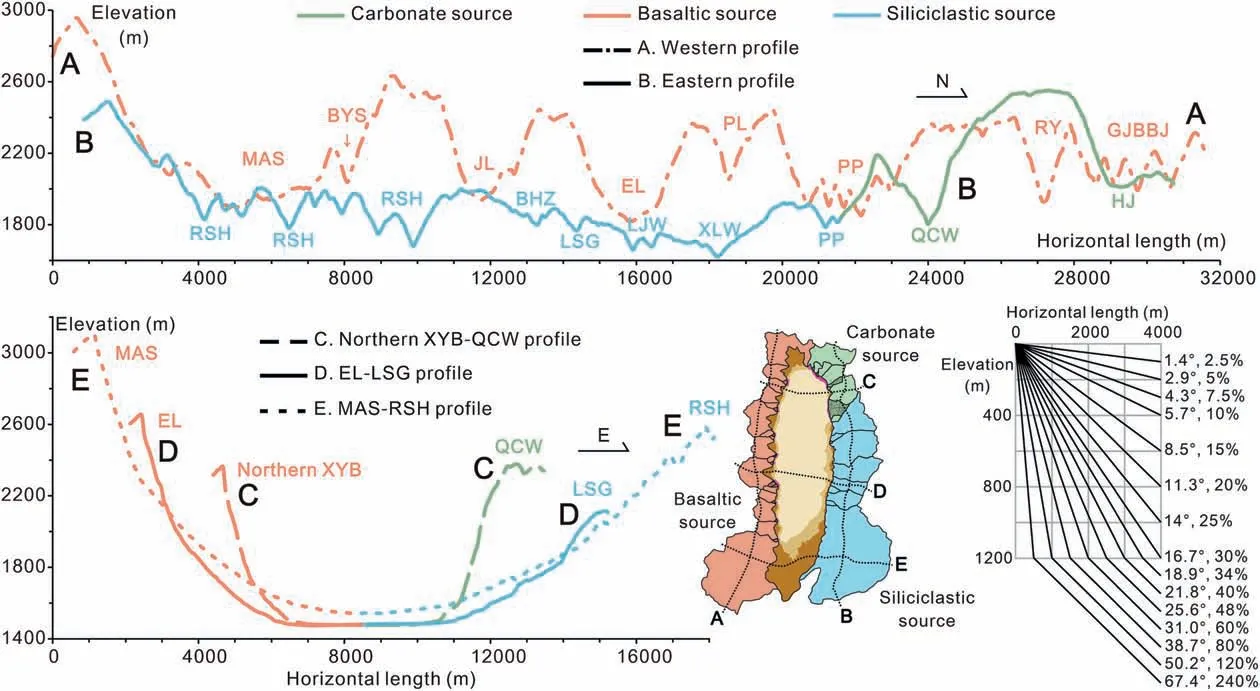
Fig.10 DEM profiles of the source areas of Lake Chenghai.A—B)North—south-trending DEM profiles which run through the basaltic(A)and the siliciclastic and carbonate(B)source areas.The Western profile(A)shows the upstream sediment-generating region with high slope angle and elevation,the downstream confluence region with low slope angle,and the high and steep drainage divides of basaltic source areas.The Eastern profile (B) shows the relatively low relief and elevation (blue line) of siliciclastic source areas and the large primitive scarps (green line) in the carbonate source areas. C—E) East—west-trending DEM profiles which run through the north (C), central (D) and south (E) of source to sink system of Lake Chenghai. The carbonate source area (green line) is the steepest with high slope angle and short length of thalweg.The siliciclastic source areas(blue lines)are the most gentle with low slope angle and long length of thalweg.The slope angle and length of thalweg of basaltic source areas (orange lines) are between that of the carbonate and siliciclastic source areas. The accurate locations of profiles are shown in Fig. 2A and the real scene shootings are shown in Fig. 4A, C—F.
Gilbert-type deltas are mainly the products of basaltic and siliciclastic confluence-type slopes,which have the characteristic of point source.Compared with highly random rolling of source materials and small-scale debris flows,the sediment flux of medium- and large-scale debris flows of basaltic and siliciclastic confluence-type slopes are more stable and sustainable. Therefore, the sizes of Gilbert-type deltas are highly correlated with the sizes of the source areas(Fig.7A).The intermediatescale and low-inertia source material flows from basaltic source areas cause the quick unloading of considerable amounts of sediment once it flows out from the mountain pass, to form thick and steep topsets (Tables 1, 4; Fig. 7F—H, 9). The high gravel concentration results in short foreset lengths and relatively high foreset angles, and the insufficient amounts of sandy, silty, and argillaceous contents result in smaller and thinner bottomsets(Tables 1,4;Figs. 7C—E, 9). The source materials in the largerscale source material flows from the V-shaped valley subtype siliciclastic source areas enter the lake after the source material crosses the mountain passes due to the higher inertia, so less source material accumulates in the topsets, making the topsets thinner(Tables 1, 4; Figs. 7F—H, 9). The lower gravel concentrations result in longer foreset length and relatively low foreset angles (Tables 1, 4; Figs. 6F, G, J,7C—E, 8F—G, 9), and the higher amounts of sandy,silty, and argillaceous contents result in thicker and wider bottomsets, smaller topset angles, smaller foreset angles, and smaller bottomset angles (Tables 1, 4; Figs. 7D—E, 9).
Above all, the 9 DEM profiles in Fig. 9 summarizes the morphological discrepancy of subaqueous colluvial aprons (Fig. 9A—B) and Gilbert-type deltas (smallscale deltas are shown in Fig. 9C—E, medium-scale deltas in Fig. 9F—G and large-scale deltas in Fig. 9H—I) between carbonate, basaltic and siliciclastic source areas.
5.3. The evolution of a subaqueous colluvial apron into a Gilbert-type delta
Material from the source areas of Lake Chenghai mainly rolls off or slides down or forms small-scale sediment that flows down scarps with slopes greater than 30°into the lake, forming subaqueous colluvial aprons. Unlike subaqueous colluvial aprons below the confluence-type slopes in the carbonate source areas,the subaqueous colluvial aprons below the confluencetype slopes in the basaltic and clastic source areas have evolved into Gilbert-type deltas that overlie the aprons,due to the increase in sediment flux.With the continuous denudation of the slopes, the Gilbert-type deltas have been rapidly expanding and have eventually come to occupy the shoreline (Figs. 4I—L, 11).
Subaqueous colluvial aprons and Gilbert-type deltas are also present in other lakes on the Earth.For example, the water depth in the southwestern section of Lake Baikal exceeds 1400 m, and its basement near the northern and southern shores comprises sections with a slope angle greater than 30°(De Batist et al.,2006;Lunina et al.,2010;Kononov et al.,2019)(Table 5; Fig. 12A—D). The source areas on the southern shore of Lake Baikal are mostly large and of the confluence-type slopes, with an average length of thalweg of 29.2 km and an average area of 353 km2(Table 5). Gilbert-type deltas that have developed along the lake are partially connected to form delta aprons. The source areas on the northern shore are mostly faulted scarps with a depth of several hundred metres and small confluence-type source areas of 5.9 km in length of thalweg and 22.1 km2in average area (Table 5), and subaqueous colluvial aprons (or subaqueous fans) have developed below these scarps and a few confluence-type slopes.
The water depth of Lake Tahoe exceeds 500 m(Table 5), the underwater sections near the southwestern shore have high slope angles, and the source areas are glacial valleys with an average length of thalweg of 6.93 km(Table 5;Fig.12E—G);subaqueous colluvial aprons have developed on the floor of the lake (Gardner et al., 1999; Horton, 2017). Large subaqueous colluvial aprons either have Quaternary loose sediments as the source or are near underwater valleys(Fig. 12H—I).
The northern margin of the Eocene Dongying Depression,a deep rift lake inside the Bohai Bay Basin(China), is the Chennan Fault (a boundary fault) (Cao et al., 2018; Zhu et al., 2018; Zhang et al., 2019),with an average slope angle of 34°(Table 5;Fig.12J).Seismic data show that subaqueous colluvial aprons that develop along the northern boundary often evolve into Gilbert-type deltas(or fan deltas)that overlie the aprons(Fig. 12K).
As another example, the Zhuoshui River inputs a large amount of coarse-grained source material into the Wushe Reservoir near Ali Mountain,Taiwan,during the rainy season. Due to the immense sediment flux,Gilbert-type deltas directly form in the reservoir with a water depth exceeding 37 m(Lai and Capart,2009).
The above examples indicate that coarse-grained source material undergoes a complex process after entering deep scarped lakes, forming subaqueous colluvial aprons and then evolving into Gilbert-type deltas. The controlling factor for this complex process seems to be the geomorphic evolution of the source areas but is essentially the sediment flux increasing which coupling with geomorphic evolution of the source areas. Scarps represent the initial landform of the source areas (Cao, 1995; Huggett, 2011),and source material rolls off or slides down scarps orforms small-scale debris flows before entering the lake, initially forming subaqueous colluvial aprons. As weathering and denudation progress,the initial scarps transform into confluence-type slopes,and the source material forms medium- and large-scale debris flows that enter the lake, resulting in sudden increases in sediment flux.Consequently,the subaqueous colluvial aprons rapidly grow and develop subaerial deposits,which evolve into Gilbert-type deltas that overlie the aprons. This process may take 1000 to 200,000 years(Kirkby, 1985; Huggett, 2011). The 27 DEM profiles along the main current direction near the front end of the basaltic source areas reveal the development and evolution which from subaqueous colluvial apron to Gilbert-type delta, and the internal sedimentary architecture of coarse-grained deposits with deep scarped lakes setting(Figs.11 and 13).

Fig.11 Response mechanism of the coarse-grained deposits in Lake Chenghai source-to-sink system.The serial numbers from“A”to “I” of source areas are in accordance with the DEM profiles of sink areas in Fig.9 and the locations of 9 source areas and 27 DEM profiles along the western shore of Lake Chenghai are shown in Fig. 2A.
In addition, to form a subaqueous colluvial apron,the slope angle of the subaqueous basement must be greater than the natural angle of repose of watersaturated gravel source material (generally 25°—27°)(Lai and Capart, 2009),and sufficient accommodation space must be available for sediments (e.g., high water depth or moderate sediment input).Otherwise,a Gilbert-type delta is formed directly after the source material entering the lake. In other words, deepscarped lakes provide suitable environments for the formation of subaqueous colluvial aprons.

Fig. 12 Formation and development conditions of coarse-grained deposits in Lake Baikal, Lake Tahoe, and Eocene Dongying Depression. A)Source area and faults in remote sensing images of southern Lake Baikal, modified from Lunina et al. (2010); B) Water depth distribution of southern Lake Baikal,modified from De Batist et al.(2006);C)Subaqueous slope angle distribution of southern Lake Baikal,modified from De Batist et al.(2006);D)A subaerial and subaqueous geomorphic profile(marked as m—n in A)of southern Lake Baikal,modified from De Batist et al.(2006);E)Geological overview of the southwestern shore of Lake Tahoe,modified from Horton(2017);F)Water depth distribution near the southwestern shore of Lake Tahoe, modified from Gardner et al. (1999); G) Subaqueous slope angle distribution near the southwestern shore of Lake Tahoe,modified from Gardner et al.(1999);H—I)DEM profiles of subaqueous colluvial aprons crossing the southwestern shore of Lake Tahoe; J) Slope angle distribution of the scarp zone in the Dongying Depression, Bohai Bay Basin, eastern China; K) A seismic profile(marked as k in J)crossing the scarp zone in the Dongying Depression.The locations(WGS-84)of related case studies are listed in the List of locations at the end of text.

Fig.13 Quantitative regime of initiation and evolution of coarse-grained deposits source-to-sink system in the Late Quaternary Lake Chenghai.The 26 DEM proflies of sink areas,which are based on Fig.11(excludes the MAS proflie),show the isochronous framework of the coarse-grained deposits in Lake Chenghai.The 26 DEM proflies along the thalweg of source area,which are in accordance with the DEM proflies of sink areas, show the evolution of erosion landform in the source areas.
6. Conclusions
(1) The source areas of coarse-grained deposits in Lake Chenghai were lithologically classified into carbonate source areas, basaltic source areas, and siliciclastic source areas, and were geomorphically categorized as scarp type or confluence type. Scarps are mainly distributed in carbonate and basaltic source areas, with slope angles mostly above 25°. The source material rolls off scarps or forms small-scale debris flows and enters the lake. The area of confluence-type slopes (slope angles mostly less than 25°) accounts for 96.7% of the total source area, with confluence-type valleys developing on their surfaces. The source material from confluence-type slopes forms medium- and large-scale debris flows that enter the lake. Subaqueous colluvial aprons have formed downstream of the carbonate source areas and basaltic scarp-type source areas,and Gilbert-type deltas have formed downstream of the siliciclastic source areas and basaltic confluence-type source areas.
(2) A subaqueous colluvial apron is composed of an apron apex and a bottomset. The apron apices are matrix-supported mudstone deposits, with average surface slope angle of 15°and average length of 121 m. The average surface slope angle of the bottomset is 3°. The topsets of Gilbert-type deltas have an average radius of 592 m and an average surface slope angle of 6°.The foresets have an average surface slope angle of 13.8°, an internal slope angle of 25°—27°, and an average length of 320 m. The sand-rich bottomset has an average surface slope angle of 2.7°.
(3) The process from the formation of a subaqueous colluvial apron to its evolution into a Gilbert-type delta is jointly controlled by the sediment flux that synchronously evolves with the geomorphic evolution of the source areas and the sink regimes. Scarps represent the initial landform of the source areas. Source material rolls off or slides down scarps or forms small-scale debris flows before entering the lake. The source material deposits in the lake and initially forms a subaqueous colluvial apron if there is sufficient space to accommodate sediments and the basement angle is greater than the natural angle of repose.As weathering and denudation progress, the initial scarps transform into confluence-type slopes,and the source material forms medium-and large-scale debris flows that enter the lake, resulting in increase in sediment flux. Consequently, the subaqueous colluvial aprons rapidly grow and develop subaerial deposits, which evolve into larger-scale Gilbert-type deltas that overlie the aprons.
(4) The morphology and distribution of subaqueous colluvial aprons and Gilbert-type deltas vary because of differences in quantity and composition of material among source areas due to different rates of weathering and denudation and different sediment input regimes. For example, the size and surface slope angle of a subaqueous colluvial apron from a carbonate source are smaller than those of a subaqueous colluvial apron of basaltic origin.A Gilbert-type delta from a basaltic source features a larger surface slope angle and a thicker topset than does a Gilbert-type delta of siliciclastic origin,and a Gilbert-type delta of siliciclastic origin exhibits a longer foreset and a thicker bottomset than does a Gilbert-type delta from a basaltic source. The sizes of subaqueous colluvial aprons are not strongly correlated with the sizes of the source areas because of the random and moderately low sediment flux from carbonate slopes and basaltic triangular-facet scarps, while the sizes of Gilbert-type deltas are strongly correlated with the sizes of the source areas because of the stable,sustainable and high sediment flux from basaltic and siliciclastic confluence-type slopes.
List of locations
The locations (WGS-84) of real scene shootings in Figs. 4, 5 and 8, facies successions in Fig. 6 and other related case studies in Fig. 12 and Table 5, are as follows.
Fig. 4A: 26.6144°N,100.7028°E;
Fig. 4E: 26.5321°N, 100.6182°E;
Fig. 4F: 26.5006°N,100.69°E;
Fig. 4I: 26.6151°N, 100.7°E;
Fig. 4J: 26.4828°N, 100.64°E;
Fig. 4K: 26.5755°N,100.6928°E;
Fig. 4L: 26.5096°N, 100.6818°E;
Figs. 5A,6A: 26.6257°N,100.6756°E;
Figs. 5B, 6B: 26.6255°N, 100.6754°E;
Fig. 5C: 26.6264°N, 100.6761°E;
Figs. 5D, 6D: 26.4837°N, 100.6417°E;
Fig. 5D—F, 6C: 26.4837°N, 100.6413°E;
Fig. 6E: 26.4784°N,100.6407°E;
Fig. 6F: 26.4778°N,100.6426°E;
Figs. 6G, 8G: 26.6049°N, 100.6894°E;
Figs. 6H, 8G: 26.6049°N, 100.6892°E;
Figs. 6I, 8D—E: 26.4921°N, 100.686°E;
Figs. 6J, 8F: 26.5089°N,100.6839°E;
Figs. 6K, 8J: 26.5096°N,100.6821°E;
Figs. 6L, 8A: 26.5743°N, 100.695°E;
Figs. 6M, 8B: 26.5746°N, 100.6937°E;
Figs. 6N, 8C: 26.5764°N,100.6925°E;
Figs. 6O, 8H—I:26.5778°N, 100.6907°E;
Fig. 8K: 26.4658°N, 100.6517°E;
Fig. 12A: 51.6403°N, 104.5882°E;
Fig. 12H: 39.0553°N, 120.103°W;
Fig. 12I: 39.0026°N, 120.0924°W;
Fig. 12J: 37.6223°N, 118.5657°E;
Table 5 (Wushe Reservoir): 24.0125°N, 121.138°E.
Authors’ contributions
DTD proposed the main academic ideas and wrote the whole manuscript. LWQ made a comprehensive analysis of the geological origin and evolution of coarse-grained deposits. PJM, and GDY are mainly responsible for collecting and processing DEM data.YZW, SBZ and XL are mainly responsible for planning and taking a share in field work. HQH, BLY, and YQY made analyses of the hydrodynamic mechanism for subaqueous debris flow.All authors read and approved the final manuscript.
Funding
This work was supported by the National Natural Science Foundation of China (Grant No. 42172115,41972099, 42102153), the China Postdoctoral Science Foundation (Grant No. 2021M693500), and the National Major Science and Technology Projects of China(Grant No. 2017ZX05009-002, 2017ZX05072-002).
Availability of data and materials
All data and materials generated and analyzed during this study are included in this published article.
Conflicts of interest
The authors declare that they have no competing interests.
Abbreviations
ALOS Advanced Land Observing Satellite;
DEM Digital elevation model
WPI Weathering potential index
SMRs Small mountain rivers
WGS-84 World Geodetic System-1984 Coordinate System
Acknowledgements
The authors would like to thank the Japan Aerospace Exploration Agency (JAXA) for providing the ALOS PALSAR DEM,Shengli Oilfield Company(part of Sinopec)for providing the seismic data for the Dongying Depression,and the China Geology Survey for providing the Heqing(G-47-17) 1:200,000 geological map. And the authors want to give special thanks to Yi-Min Liu and Yuqian Philomena Gan for their abundant advice. Finally, the authors would like to offer special thanks to their families for their constant support and encouragement.
杂志排行
Journal of Palaeogeography的其它文章
- Basin-filling processes and hydrocarbon source rock prediction of low-exploration degree areas in rift lacustrine basins: a case from the Wenchang Formation in low-exploration degree areas, northern Zhu I Depression, Pearl River Mouth Basin, E China
- Provenance studies on the heavy mineral placers along the coastal deposits of Odisha,eastern India
- Sediment provenance of a carbonate bioclastic pocket beach — Le Dune (Ionian Sea, South Italy)
- Detrital zircon ages of Oligocene to Miocene sandstone suites of the Southern Apennines foreland basin system, Italy
- Tracking sources and paleotectonic settings of Mesozoic sandstones in interlinked rift basins of western India: An integrated approach using petrography and heavy mineral chemistry
- The primary dolostone in the Meso-Neoproterozoic: Cases study on platforms in China