Analysis of the Winter Cloud-to-Ground Lightning Activity and Its Synoptic Background in China during 2010-20
2022-04-02ManmanMAXiaogangHUANGJianfangFEIChiZHANGChaoLIandXiaopingCHENG
Manman MA, Xiaogang HUANG*, Jianfang FEI, Chi ZHANG, Chao LI, and Xiaoping CHENG
1College of Meteorology and Oceanography, National University of Defense Technology, Changsha 410073, China
2Unit 94116 of PLA, Hetian 848000, China
3Jiangsu Meteorological Observatory, Nanjing 210008, China
ABSTRACT Cloud-to-ground (CG) lightning data and the ECMWF ERA-Interim reanalysis dataset are analyzed to gain insight into the spatiotemporal distribution and synoptic background of winter-season CG flashes between December 2010 and February 2020 in China. We identify three Winter Lightning Frequent Areas (WLAs): the southwest side of the Yunnan-Guizhou Plateau (WLA1), the east side of the Yunnan-Guizhou Plateau (WLA2), and the Poyang Lake Plain (WLA3). The CG lightning flashes most frequently occur at local midnight and have a monthly peak in February. The CG lightning in WLA1 is mostly generated in non-frontal weather; however, the lightning in WLA2 and WLA3 mostly occurs in frontal systems. The frontal circulation situation is divided into four typical types: transversal trough after high pressure, low vortex, confrontational convergence, and asymptotic convergence. In all typical weather patterns, the lightning occurs downstream of a 500 hPa trough and is accompanied by a southwesterly low-level jet. The convective parameters of winter thunderstorms differ greatly from those of summer thunderstorms. The maximum convective available potential energy(MCAPE) and K-index (KI) are more useful metrics than convective available potential energy (CAPE) and Showalter index (SI) during winter. This study further deepens the understanding of the distribution characteristics of winter CG lightning in China, which motivates further research to improve the ability of winter thunderstorm prediction.
Key words: winter thunderstorms, CG lightning, spatiotemporal characteristics, ADTD
1. Introduction
Lightning is an atmospheric discharge phenomenon associated with convective weather and poses a serious threat to human life and property. It causes an average of 387 deaths and 359 injuries on the Chinese mainland each year (Zhang et al., 2012) and accounts for 2% of all natural hazards in Asia from 1970 to 2019 (World Meteorological Organization, 2021). Convective weather in China mostly occurs during the warm season, evidenced by 97% of all cloud-toground (CG) lightning discharges occurring between March and September (Yang et al., 2015). Due to the rarity of lightning in winter (December to February), forecasters often miss or overlook thunderstorms (Zheng and Jin, 2012; Liu et al., 2020), which restricts the improvement of convective weather forecasting in winter.
With the development of lightning location networks,the spatial and temporal distribution characteristics of CG lightning in various areas have been studied worldwide,such as the United States (Orville and Silver, 1997; Orville and Huffines, 2001,), Brazil (Bourscheidt et al., 2009),Europe (Antonescu and Burcea, 2010), Japan (Shindo et al.,2016), and South Korea (Hyun et al., 2010). There are also many studies about the spatiotemporal distribution characteristics of CG lightning in China (Xia et al., 2015; Yang et al.,2015). Previous works have found that the seasonal distribution characteristics of CG lightning in China are similar to those of other countries, i.e., relatively infrequent in winter(Yuan and Qie, 2004). The peak current of positive CG(PCG) lightning is greater than negative CG (NCG) lightning, but the proportion of PCG (PPCG) lightning is less than 10% of the annual average (Qie et al., 2015). The centers of maximum mean annual CG lightning density areas are scattered throughout southern China, including the Sichuan basin and the southern areas of Jiangsu Province(Yang et al., 2015). The CG lightning temporal distributions in small regions, such as Beijing (Wang et al., 2020),Hubei (Chai and Sun, 2019), Guangdong (Zheng et al.,2016), northwest Sichuan (Yang et al., 2018), and Yunnan provinces (Xie et al., 2013), are similar to the Chinese national average, with the annual peak in summer and diurnal peak around 1700-1800 LST (Local Standard Time,LST=UTC+8).
Compared with the other three seasons, winter lightning has the comparative characteristics of lower frequency of occurrence, a higher percentage of PCG flashes (PPCG),and a larger peak current-characteristic of PCG lightning(Orville and Huffines, 2001; Yang et al., 2015). Thus, the destructive effect of winter lightning is nonnegligible. Nevertheless, most research has focused on lightning in the warm season (Lericos et al., 2002; Yang et al., 2020) and annual statistics, which cannot accurately describe the spatial and temporal characteristics of winter lightning. Xia et al.(2015) and Wang and Chen (2015) used ground-based Advanced Time of Arrival and Direction (ADTD) system CG lightning detection data and found that only a small amount of winter lightning occurred in the lower reaches of the Yangtze River. However, according to the lightning distribution characteristics calculated from satellite data, Chinese winter lightning occurred more frequently towards the South China Coast (Yuan and Qie, 2004). Some of the results are contradictory; it is thus necessary to further study the distribution characteristics of winter lightning in China.
Deep moist convection that produces lightning requires a conditionally unstable environment, sufficient moisture,and some process by which a parcel is lifted to its level of free convection (LFC) (Doswell, 1987; Doswell et al.,1996). Specific weather patterns are needed to trigger convection due to the lower surface sensible heat flux experienced in winter. For example, winter lightning in the Iberian Peninsula has a frontal origin and is mainly associated with western or cyclonic flow situations. However, summer lightning can occur in tandem with eastern or anticyclonic flow due to convection triggered by insolation (Ramos et al., 2011;Royé et al., 2018). In the United States, the weather patterns that produce winter lightning can be classified into either an Arctic front or a migratory cyclone (Hunter et al.,2001). However, studies on the winter thunderstorm patterns of China are few. From the works that investigated individual cases of thundersnow in China, the lightning zone is usually located downstream of a 500 hPa trough (Yu et al.,2016) and is accompanied by vigorous warm and moist low-level flows-between 850 and 700 hPa (Zheng and Jin,2012; Huang et al., 2017). Moreover, most winter lightning is associated with frontal systems (Yu et al., 2016). In addition, many cases of thundersnow arise within elevated thunderstorms (Yu et al., 2016; Huang et al., 2017).
The China Meteorological Administration Lightning Detection Network ADTD network has been an evolving nationwide project for many years (Qie et al., 2014); and its data have been widely utilized (Xia et al., 2015; Li et al.,2021). The network makes it possible to study convection in winter over long time intervals and across wide areas in China. Here, we employ CG lightning data from December 2010 to February 2020 to study the spatiotemporal distribution of winter CG lightning. These data are used to explore the associated weather patterns and convective parameters.
The remainder of this paper is organized as follows. Section 2 describes the data and the methods used to group strokes to flashes. Section 3 introduces the temporal and spatial distribution characteristics of winter CG lightning. Section 4 introduces typical weather patterns conducive to winter CG lightning in China. Section 5 investigates the relative applicability of traditional convective parameters to winter thunderstorms. Section 6 provides a summary and conclusions.
2. Data and methods
The CG lightning data used in the study is obtained by the ADTD-1 network, which can detect CG lightning across the country and in surrounding seas (Ma, 2015). By the end of 2017, there were 406 ground-based CG lightning detection sensors with an average operational rate of 98.14%(China Meteorological Administration, 2018). Data quality control is performed by removing positive strokes of less than 15 kA (Cummins and Murphy, 2009) to eliminate possible intra-cloud lightning. To convert strokes data into flashes, we assume that the strokes contained within the same flash have locations within 15 km of the first stroke,the time interval between consecutive strokes is less than 400 ms, and the total duration of a flash is limited to less than 1.5 s (Qie et al., 2021). Because bipolar CG lightning is arguably one of the rarest types of lightning (Xue et al.,2015), we also assume that the strokes with different polarities belong to different flashes (Pinto et al., 2003). The location, intensity, and polarity of the first stroke are used to determine the flash information (Xia et al., 2015). Ten years of winter lightning data from December 2010 to February 2020 are employed; winter is defined as the period from December to February of the following year. The study area is divided into 0.5° × 0.5° grids, which allows for spatial coordination between the lightning and reanalysis data. Additionally, it should be noted that the values related to lightning characteristics in this paper are calculated based on existing data, without correcting for ADTD detection efficiency.
The reanalysis data used in this study are from the ERA-interim consistent with the pressure levels from the European Center for Medium-Range Weather Forecasts(ECMWF), with a time resolution of 6 h, i.e., 0200, 0800,1400, and 2000 LST and a spatial resolution of 0.5° × 0.5°.Since ERA-Interim data is only updated to 31 August 2019,ERA5 data with a spatial resolution of 0.25° × 0.25° is used for 2019 winter, which is upscaled into 0.5° × 0.5° spatial resolution.
Lightning is prevalent in thunderstorm clouds, represented by a cluster of dense lightning records within short time intervals. Therefore, clustering algorithms can be used to identify thunderstorm centers. Clustering by Fast Search and Find of Density (CFSFD) proposed by Rodriguez and Laio (2014) has been applied to thunderstorm identification and achieved good results (Zhou et al., 2016). The time interval of CFSFD is 10 minutes, and the critical values of local density (ρmin) and distance (δmin) are 1.5 and 20 km, respectively (Zhou et al., 2016). This method is simpler than traditional clustering algorithms. The main idea of CFSFD is that cluster centers are characterized by a higher density than their neighbors and by a relatively large distance from points with higher densities (Rodriguez and Laio, 2014).
To balance the authenticity of the lightning data with the complexity of calculation, the flash data are used to explore the spatiotemporal distribution of winter CG lightning and help diagnose the typical weather patterns and the thunderstorm center obtained by CFSFD is used to compare the convective parameters.
3. Spatial and temporal distribution of CG lightning in winter
3.1. Spatial distribution of CG lightning days and CG lightning density
Cloud-to-ground (CG) lightning days are widely used to analyze thunderstorm occurrences. According to a method of defining CG lightning days by Yang et al.(2015), at least two flashes in a 0.5° × 0.5° cell between 0000 and 2400 LST is regarded as a CG lightning day in that cell. The spatial distribution of all winter CG lightning days for 2010-20 is shown in Fig. 1a. There are three winter lightning frequent areas (WLAs), WLA1, WLA2, and WLA3, ordered from west to east. The westernmost area,WLA1, is located in southwestern Yunnan Province, in the Ailao Mountains, with its southwest edge on the southwestern boundary of the Yunnan-Guizhou Plateau. The region is mountainous, with low elevations to the southwest and high elevations to the northeast. The central area, WLA2, is located at the junction of Hunan, Guizhou, and Guangxi Provinces, near Xuefeng Mountain and Wuling Mountain on the eastern boundary of Yunnan-Guizhou Plateau. The easternmost area, WLA3, is located in the Poyang Lake Plain area in northeastern Jiangxi Province, including a small part of southern Anhui Province and western Zhejiang Province. The following mountains surround this area:the Dabie Mountains, the Nanling Mountains, the Luoxiao Mountains, and Mount Huangshan in the north, south, west,and east of WLA3, respectively. Cloud-to-ground (CG) lightning days in WLA2 are most frequent, with more than 2.6 d winter-1in most areas. In WLA3, the thunderstorm days are fewest, with only a few grids around Jingdezhen experiencing more than 2.4 d winter-1.
Figure 1b shows the distribution of CG flash density in winter thunderstorms. CG flash density is defined as the average number of CG flashes per square kilometer per winter(fl km-2winter-1). The area of each grid in Fig. 1b is calculated by treating the earth as a sphere. As shown in Fig. 1,high CG flash density roughly coincides with high numbers of lightning days. The highest CG flash density is in eastern Guizhou Province and western Hunan Province, west of WAL2. In addition, there are scattered high CG lightning density areas in southeastern Yunnan Province, northeastern Jiangxi Province. WLA2 has the highest mean CG flash density (0.023 fl km-2winter-1), while the CG flash density of WLA1 is the lowest (0.014 fl km-2winter-1; Table 1).Because winter lightning is rare in areas north of the Yangtze River, the mean national CG lightning density is generally an order of magnitude less (0.0023 fl km-2winter-1).
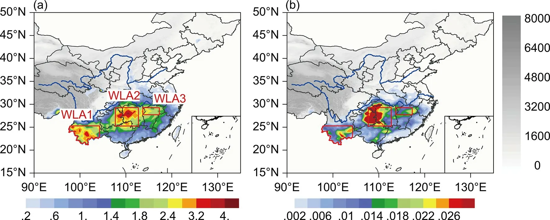
Fig. 1. Spatial distribution of the frequency of winter CG lightning days (d winter-1; a) and CG flash density (fl km-2 winter-1; b) within the three WLAs (red boxes) during the winters of 2010-20. The horizontal resolution of lightning days and lightning flash density is 0.5° × 0.5°. The gray shading represents topography, with lighter shading denoting a lower elevation (m). Blue curved lines represent the Yellow River and the Yangtze River.
3.2. Winter thunderstorm processes
Most winter thunderstorms are systematic, so we can judge whether lightning records at different moments are caused by the same thunderstorm process by analyzing atmospheric circulation patterns and the continuity of lightning records with precipitation. Combining precipitation and lightning observation, a thunderstorm process is defined as a discrete weather system featuring a continuous process having more than 50 flashes within 6 hours and significant precipitation. A thunderstorm process is considered to affect the WLA if at least one flash in a lightning cluster is located in a WLA. This implies that a strong, persistent thunderstorm process can affect two or three WLAs. As shown in Table 1,China is affected, on average, by 9.6 thunderstorm processes each winter (pro winter-1). The westernmost region,WLA1, is most susceptible to thunderstorms, with an average of 5.1 pro winter-1. In WLA1, the center of most lightning clusters is located outside China, but the edge of the lightning cluster affects the Yunnan area. Although the frequency of thunderstorm processes in WLA2 is slightly lower (4.7 pro winter-1), in contrast to WLA1, most lightning cluster centers of the thunderstorm processes that affect WLA2 are located in WLA2. The least number of thunderstorm processes occurs in WLA3, with an average of only 3.1 pro winter-1.

Table 1. Winter CG lightning summary for China and three WLAs during the 10-yr period of 2010-20.
3.3. Percentage of positive cloud-to-ground (PPCG)lightning
In most areas of China, NCG lightning is dominant in winter, and the PPCG lightning is 26.1% nationwide. Only the coastal areas of Guangdong Province, southeastern and southwestern Yunnan Province, and the junction of southeast Tibet and India have a PPCG lightning exceeding 50%(Fig. 2). The higher PPCG lightning in the southern frontier region of Yunnan Province is consistent with the findings of Xie et al. (2013). The reason for the higher PPCG lightning in this region may be that the peak current of PCG lightning is larger than that of NCG lightning, leading to a higher detection ratio of PCG lightning (Orville and Silver,1997). The national average peak current of PCG and NCG lightning is 73.0 kA and 47.0 kA, respectively. This difference is nearly double, consistent with the average annual peak current of positive and negative CG lightning (Li et al., 2011). Previous research has pointed out that the PPCG lightning during the cold season is higher compared to the warm season (Orville and Silver, 1997; Antonescu and Burcea, 2010; Xie et al., 2013; Yang et al., 2015). The higher PPCG lightning in winter may be attributed to an inverted charge structure [an upper negative charge and part of the positive charge below it; Wang et al. (2021)]. Owing to the weakened convection in winter, active electrification occurs in regions near or warmer than the reversal temperature, which causes the graupel particles to gain positive charges and ascending ice crystals to acquire negative charges upon collision with each other (Takahashi, 1978).The charging between snow/aggregates (which gain positive charge) and ice crystals (which gain negative charge;Williams, 2018) is supposed to be another mechanism for the inverted charge structure (Zheng et al., 2019). The inverted charge structure of winter thunderstorms has been verified in Japan (Zheng et al., 2019), but related studies are lacking in China. Considering the difference in the PPCG lightning in winter between China and Japan, the charge structure of Chinese thunderstorms is worthy of further study.
There is some difference in peak current and the PPCG lightning between the three WLAs. In WLA2, the average peak current of PCG and NCG lightning is 82.4 kA and 52.8 kA, respectively, which represents the strongest average peak current among the three WLAs, noting that the PPCG lightning there is 21.6%. The PPCG lightning of WLA1 is the highest (35.6%), while the mean peak currents of PCG and NCG lightning are the lowest (65.0 kA and 34.5 kA). The PPCG lightning in WLA3 is 25.2%, and the mean peak current of PCG and NCG lightning is 69.3 kA and 41.4 kA, respectively.
3.4. Temporal distribution
The monthly and diurnal variation in accumulated winter CG flashes is shown in Fig. 3. From a national perspective (Fig. 3a), the frequency of CG lightning is the highest in February, consistent with the CG lightning distribution results calculated by Yang et al. (2015). January hasonly about one-third of the CG lightning than does February. The number of CG flashes in December is an order of magnitude lower than that in February. The diurnal variation shows a unimodal distribution, and the trend of the diurnal variation over the three months is the same. The frequency of CG lightning in the morning (2300-0100 LST) is three times that of the middle of the day (1100-1200 LST),which is quite different from the diurnal variation of summertime convection, which occurs mostly in the afternoon(Yang et al., 2020). This diurnal variation is similar to,although more profound than, the temporal distribution characteristics of winter CG lightning in the United States (Bentley et al., 2019).
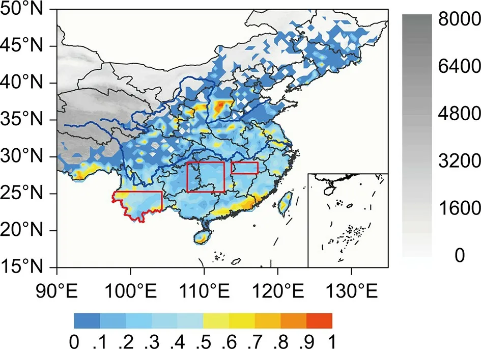
Fig. 2. Spatial distribution of PPCG flashes (%) within a 0.5°× 0.5° grid during the winters of 2010-20. The horizontal resolution of lightning days and lightning flash density is 0.5°× 0.5°. The gray shading represents topography, with lighter shading denoting a lower elevation (m). Blue curved lines represent the Yellow River and the Yangtze River. Red boxes denote the three WLAs.
The temporal variation in CG lightning in WLA2 (Fig.3c) is consistent with the national observation but exhibits a more profound diurnal variation due to a much larger sample size of CG lightning events.
The frequency of CG lightning is lowest in WLA3, and its temporal distribution (Fig. 3d) is substantially different from that of the entire country. In terms of monthly variation, the largest amount of CG flashes occurs in February,and the frequency of both January and December is about one-sixth that of February. The diurnal variation in WLA3 is complex. The highest number of CG flashes occurs in the early morning hours, 0000-0100 LST in December and 0500 LST in January. There are two peaks in February,close to 0000 and 0500 LST. In general, CG lightning in WLA3 is more frequent in the early morning and less frequent in the daytime.
The CG temporal distribution of WLA1 (Fig. 3b) is substantially different from that of other WLAs. From the monthly variation perspective, the number of lightning flashes in January and February is nearly equal; and the frequency of lightning in December is the least, about a quarter of that observed in January. The diurnal variation in winter shows a bimodal distribution (0100 LST and 1800 LST),with the highest peak in the afternoon, similar to the annual diurnal variation in Yunnan (Xie et al., 2013). The cause for the afternoon peak may be attributed to the blocking effect of the Yunnan-Guizhou Plateau, which makes it difficult for cold air to reach WLA1. Combined with the lower latitude,higher temperature, and larger relief, afternoon, local convection occurs more easily in WLA1.
4. Typical weather patterns accompanying winter CG lightning
By analyzing the weather patterns of all winter thunderstorms, CG lightning mostly occurs during convective weather when southward-moving cold air meets warmer air.Some weather patterns can generate flashes without a front,such as CG lightning in southwest Yunnan. Therefore, according to the weather situation at 1000 hPa, the weather patterns of winter CG lightning in China are manually divided into two types: frontal and non-frontal. In the frontal weather patterns, the location of the frontal zone is manually determined according to the convergence of cold and warm currents. Combined with the most frequent CG lightning location, the frontal patterns can be further manually divided into three types: pre-frontal, near-frontal, and postfrontal. Following Hunter et al. (2001), to make lightning data and reanalysis data coincide in time, a period is defined based on the temporal resolution of reanalysis data. If there are at least 50 CG lightning flashes within three hours before and after this moment, this six-hour interval is defined as a period. Different weather patterns are divided according to the 1000 hPa synoptic pattern for the middle time of the period. If most of the lightning occurs in the presence of a northerly wind, the pattern is post-frontal. If the predominant CG flashes occur during a southerly wind, the pattern is pre-frontal. If there is no significant difference or the number of lightning records occurs in the presence of both southerly and northerly winds, the pattern is classified as near-frontal. Figure 4 describes the spatial relationship between the lightning zone and the front. Only the location of lightning is considered, and the movement of the front is ignored. In addition, most winter lightning is related to the cold frontal process in China. Thus, the difference between warm and cold fronts is ignored, and we assume that all lightning occurs in the vicinity of the cold front.
Figure 5 shows the proportion of CG lightning in the various weather patterns across China and the three WLAs.About 69% of CG flashes occur in the frontal weather pattern nationwide. Among these CG flashes, about 8% are pre-frontal, 38% are post-frontal, and about 23% are classified as the near-frontal type (Fig. 5a).
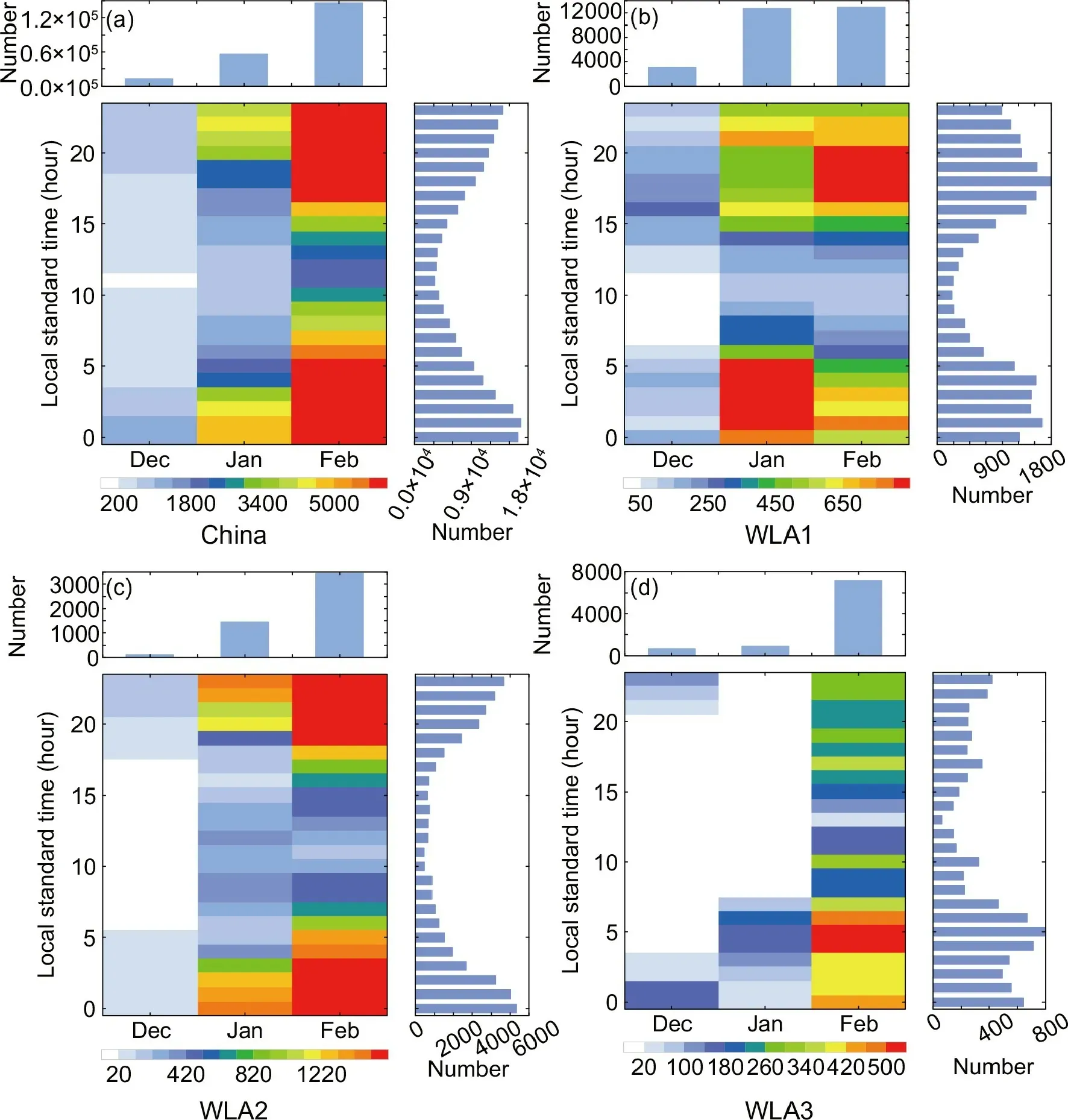
Fig. 3. Monthly and diurnal variations of accumulated winter CG lightning flashes in China (a), WLA1 (b), WLA2(c), and WLA3 (d) from 2010 to 2020. The top histogram shows the monthly variation of all winter flashes in the region, and the right histogram shows the diurnal variation of all winter flashes in the region.
The proportion of various weather patterns in the three WLAs is quite different. In WLA1 (the furthest south of the three WLAs), 83% of CG flashes occur in the non-frontal pattern (Fig. 5b). Theoretically, all flashes in WLA1 should be non-frontal, but the classification method resulted in 17% of lightning with front. The classification method is when the vast majority of lightning at a given moment is of a frontal type, all lightning occurring at this moment is classified as a frontal pattern. WLA2 is located in latitudes between the other two WLAs and has the highest CG lightning frequency. The proportion of CG flashes in non-frontal weather patterns is 13%, and the amount of CG flashes occurring in the post-frontal type is largest in WLA2 (46%) (Fig.5c). In WLA3 (the furthest north among the three WLAs),CG flashes mainly occur in the post-frontal weather pattern(70%), while the CG flashes in non-frontal patterns account for only 15% of the wintertime total (Fig. 5d).
4.1. Non-frontal pattern
Analysis of the CG lightning field in winter shows that the circulation depiction without fronts is relatively simple.Most lightning in the non-frontal type is located in Yunnan Province. Elsewhere, the counts of flashes in the non-frontal type are usually less than five records per period. Therefore,only the non-frontal types in Yunnan Province are discussed. Since the elevation of the Yunnan-Guizhou Plateau is between 400 and 3500 m (Zhao and Chen, 2004), only the circulation field above 700 hPa is analyzed. Fourteen typical cases belonging to the non-frontal pattern in southwestern Yunnan Province are selected for composite analysis,and the results are shown in Fig. 6. Due to the influence of the South Branch Trough (some cases have closed low-pressure circulation), the lightning zone is controlled by the southwesterly jet downstream of the trough. Water vapor from the Indian Ocean is constantly transported into the vicinity of the Yunnan-Guizhou Plateau, causing the relative humidity in the CG lightning zone to exceed 85%. In addition, the West Pacific Subtropical High (WPSH) is strong, and the lightning zone is located on the northwestern side of the WPSH, which further strengthens the southwesterly jet. The terrain of the lightning zone displays a spatial gradient that is low in the southwest and high in the northeast, aligning with the Yunnan-Guizhou Plateau, which leads to the accumulation of warm moist air southwest of the Ailao Mountains.The lightning zone is also downstream of the trough at 500 hPa, which is conducive to the generation of convective weather.
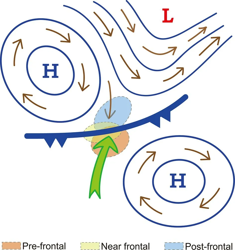
Fig. 4. Schematic diagram of the method for judging the relative locations of lightning zone and front. Geopotential height (blue lines), horizontal winds (brown vectors), and warm moist flow (green vector) at 1000 hPa are shown. Winter lightning zones of pre-frontal, post-frontal, and near frontal weather patterns are shown in red, light blue, and yellow,respectively.
4.2. Frontal pattern
The weather situation of the frontal patterns is much more complicated and is divided into the following types,low vortex, confrontational convergence, asymptotic convergence, transversal trough after high pressure, and other.Other types include situations with small amounts of lightning, inconspicuous weather patterns, and topographic fronts in the northern part of the Yunnan-Guizhou Plateau.The frequency and proportion of CG flashes and periods are shown in Table 2. From the perspective of the periods, the transversal trough after high pressure type is the most frequent, accounting for 38.3% of the frontal pattern total. The periods for the low vortex type are the least at 10.4%. The confrontational convergence and asymptotic convergence types account for 19.9% and 15.2% of the periods, respectively. In addition to these four typical patterns, there are 16.1% of other types. From the perspective of CG flash frequency, the transversal trough after high pressure has the highest proportion of flashes at 62.1%. The low vortex, confrontational convergence, and asymptotic convergence types constitute 5.9%, 13.2%, and 12.2% CG flashes, respectively. Other types only account for 6.6% of the flashes.Although other types contain a large number of periods(16.1%), the number of CG flashes is relatively small, averaging only 228.3 CG flashes per period. Among the four typical weather patterns, the transversal trough after high pressure has the most CG flashes per period [906.9 fl (6 h)-1], followed by the asymptotic convergence [450.2 fl (6 h)-1], and the low vortex and confrontational convergence have fewer CG flashes [315.2 and 368.9 fl (6 h)-1, respectively].

Table 2. Summary of the number and proportion of periods and flashes in various types of weather patterns in China.
We then search for periods when the circulation pattern is fairly obvious and when lightning concentrates in a certain area to make a composite analysis among the four typical weather patterns. Five to ten cases are selected for each pattern, and the results are shown in Fig. 7.
Ten typical CG lightning periods occurring in the eastern part of the Yunnan-Guizhou Plateau are used to describe the transversal trough after high pressure pattern (Fig. 7a).At 850 hPa, the WPSH is stronger, and the ridge on its northwest side extends westward to North China. There is an area of low pressure to the west of the WPSH, and the low-pressure center is located in the western Sichuan Basin, oriented southeast and northwest, extending to the Yunnan-Guizhou Plateau. The low interacts with the WPSH and forms a trough over the Yangtze River Basin, while the ridge of high pressure controls South China. Under the combined effect of the high- and low-pressure systems, there is a strong southwesterly low-level jet on the east side of the Yunnan-Guizhou Plateau, causing the relative humidity to exceed 95% over a widespread area. Influenced by the lowpressure trough and the positive vorticity downstream of the 500 hPa trough, there is dynamically-forced upward motion and low-level convergence, which is conducive to the production of convective weather. This weather pattern mainly occurs in areas south of the Yangtze River.
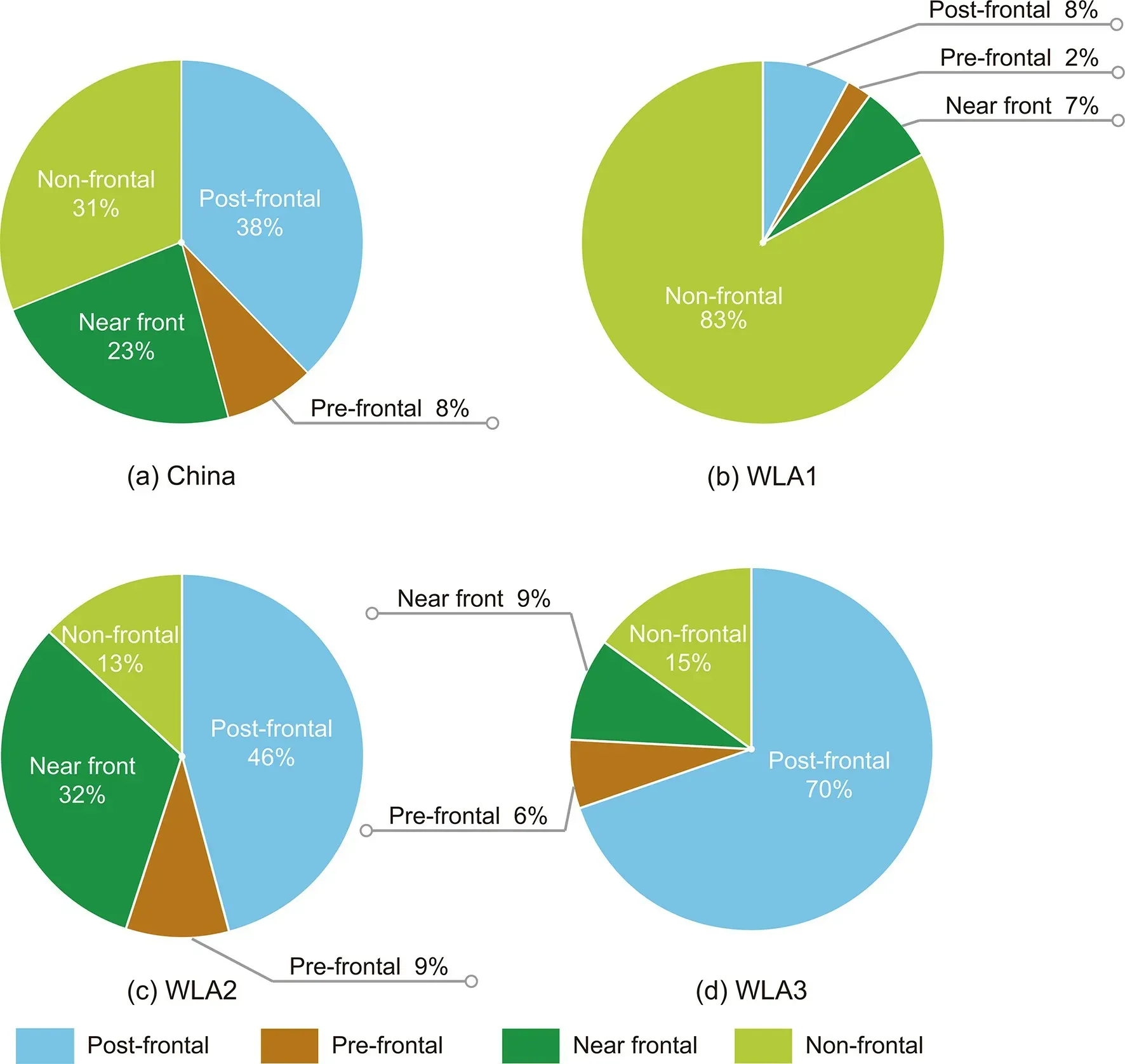
Fig. 5. The proportion of winter CG lightning flashes in China (a) and three WLAs (b-d) occurring in post-frontal(blue), pre-frontal (brown), near frontal (battle green), and non-frontal (light green) weather conditions.
Figure 7b shows the low vortex pattern, which assumes the composite field of five typical periods in the Yangtze River and Huaihe River Valley. At 850 hPa, a cyclonic vortex in northern Jiangsu Province occurs in the low-pressure zone between the cold high pressure in the northwest and the WPSH to the southeast. Under the influence of the strong WPSH, a low-level jet transports warm and moist air toward the lightning zone. The cold high on the northwest side continuously transports dry and cold air to the Yangtze River and Huaihe River Valley, resulting in the convergence of cold and warm air. Moreover, the lightning zone is located downstream of the 500 hPa trough, favorable for low-level convergence and ascent. The synoptic pattern produces convective weather with large amounts of lightning.This type of weather situation occurs mostly in the Yangtze River and Huaihe River Valley.
Nine typical CG lightning periods on the east side of the Yunnan-Guizhou Plateau are taken as examples to show the circulation pattern of confrontational convergence(Fig. 7c). This type is similar to the low vortex pattern except that the low-pressure zone between the two high-pressure centers does not form a closed low pressure. The confrontational convergence of the warm moist air transported from the southwest (the northwest flank of the WPSH) and the cold air intrusion from the northeast (southeast flank of the cold Mongolian high), working in conjunction with the positive vorticity advection downstream of the 500 hPa trough, results in convective weather, which is located on the east side of Yunnan-Guizhou Plateau.
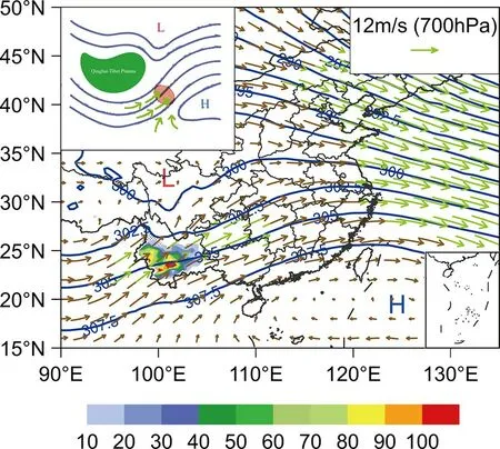
Fig. 6. Composite field of typical non-frontal weather pattern with winter CG lightning in southwest Yunnan. Geopotential height (blue lines), horizontal winds (vectors; green denotes a wind speed ≥12 m s-1), and high humidity region ( ≥85%,area filled with dots) at 700 hPa are shown. The rainbow color indicates the number of winter CG lightning flashes within a 0.5° × 0.5° cell. The small image in the upper left is a conceptual map of the weather pattern. The green vectors represent the strong warm moist flow, the green area represents the Qinghai-Tibet Plateau, and the red area is where lightning occurs.
Figure 7d shows the asymptotic convergence pattern,using a composite field of seven typical CG lightning periods in the southern lower Yangtze River valley. There are two main influencing systems at 850 hPa-the powerful WPSH and a low-pressure trough extending from the Sea of Okhotsk to the Huanghe-Huaihe area-and the lightning zone is located at their junction. The southwesterly lowlevel jet on the northwest side of the WPSH continuously transports warm and moist air to the lightning zone, while the low-pressure trough guides the dry and cold air from the north to the lower Yangtze River. These contrasting airflows produce low-level convergence downstream of the 500 hPa trough, where positive vorticity advection tends to force ascent. In this way, thunderstorms are generated.
The lightning zones of four typical patterns are all located downstream of the 500 hPa trough, and a wide expanse of ascending air is located mostly downstream of the 700 hPa trough. The differences in the synoptic situation, all ultimately resulting in convergence at 850 hPa, are quite large.The common features are that the WPSH is stronger, and the lightning zone is located along the northwestern flank of the WPSH, accompanied by a southwesterly, moistureladen low-level jet so that the relative humidity in the lightning zone exceeds 95%.
5. Convective parameters
According to an ingredients-based methodology(Doswell, 1987; Doswell et al., 1996), convection requires three main conditions: water vapor, uplift, and instability.The first two conditions can be assessed in the context of the weather situation, and instability is often assessed based on convective parameters. A considerable proportion of winter thunderstorms are elevated, but the traditional convective parameters mostly consider lifting air masses from the boundary layer (Hunter et al., 2001). Thus, the applicability of convective parameters to winter thunderstorms needs to be further discussed.
There are many winter CG lightning flashes in China(more than 210 000 flashes in 10 winters). Therefore, it is difficult to calculate convective parameters of the flashes one by one. The CFSFD process is adopted for thunderstorm center identification in this study. The cluster center represents the location of every thunderstorm center within 10 minutes, which means that for a single thunderstorm, there is a cluster center for every 10 minutes of its life. Since the“thunderstorm center” mentioned in this paper refers to the cluster centers every 10 minutes, there is not a consistent one-to-one match between cluster centers and the number of thunderstorms. The number of cluster centers obtained by CFSFD is one order of magnitude lower than the number of flashes, which greatly simplifies the calculation of convective parameters.
Four convective parameters-convective available potential energy (CAPE), maximum convective available potential energy (MCAPE), K-index (KI), and the Showalter index (SI)-for every thunderstorm center are calculated.The joint distribution of various convective parameters for thunderstorm centers in frontal and non-frontal weather patterns is shown in Fig. 8. The calculation method of MCAPE is as follows: the parcel with the largest equivalent potential temperature, at any level, for a given point is regarded as the most unstable parcel, and its CAPE value is the MCAPE for this cell (Colman, 1990).
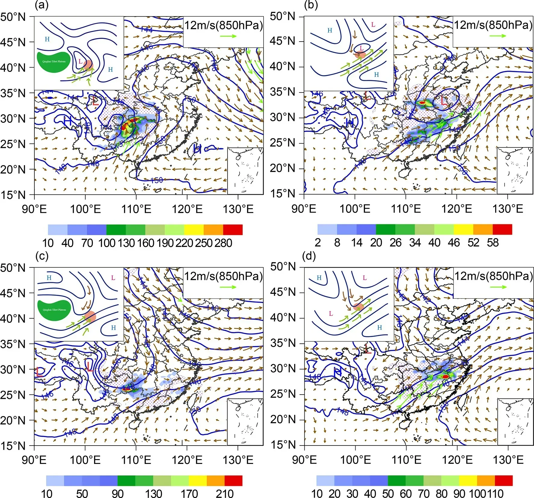
Fig. 7. Composite field of four typical frontal weather patterns, transversal trough after high pressure (a), low vortex(b), confrontational convergence (c), and asymptotic convergence (d), with winter CG lightning. Geopotential height(blue lines), horizontal winds (vectors; green denotes a wind speed ≥12 m s-1), and high relative humidity regions(≥90%, area filled with dots) at 850 hPa are shown. The rainbow color indicates the number of winter CG lightning flashes within a 0.5° × 0.5° cell. The small image in the upper left corner is a conceptual map of the weather pattern.The green and brown vectors represent the strong warm-moist and cold-dry flows, respectively, and the green area represents the Qinghai-Tibet Plateau, and the red area is where lightning occurs.
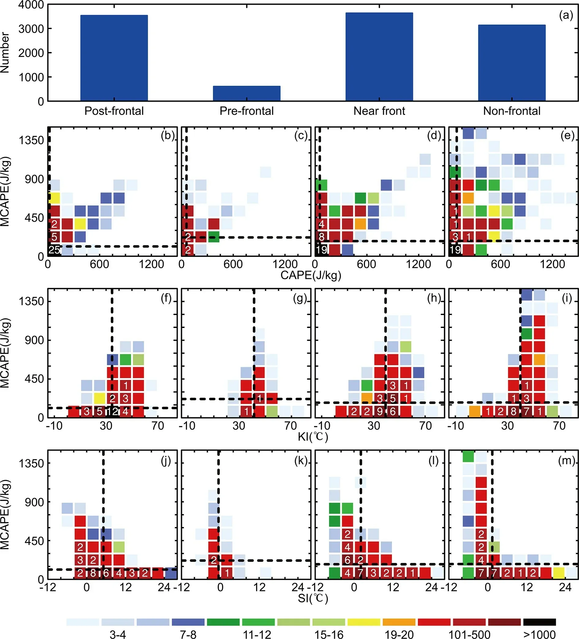
Fig. 8. The number of thunderstorm centers in the four weather patterns (a), and the joint probability density function(shaded) of MCAPE-CAPE (b-e), MCAPE-KI (f-g), and MCAPE-SI (j-m) in post-frontal (b, f, j) pre-frontal (c, g, k), near frontal (d, h, l), and non-frontal (e, i, m) weather patterns. The black dotted lines represent the average value of each convective parameter, and the value on the color block is the number of thunderstorm centers within this range divided by 100.
Convective available potential energy (CAPE) is the most commonly used parameter to measure atmospheric instability; however, it does not apply to winter thunderstorms (Figs. 8b-e). Most thunderstorms in frontal and nonfrontal weather patterns do not have appreciable CAPE, averaging less than 100 J kg-1. The mean CAPE value for the non-frontal pattern is the largest, at about 100 J kg-1. The maximum CAPE is less than 1500 J kg-1, which is substantially less than summer thunderstorms (Dong et al., 2019).Because of the strong inversion layer in the lower levels of an elevated thunderstorm, the stratification of parcels in the boundary layer is stable, and MCAPE can make up for the deficiency of CAPE to a certain extent. The average MCAPE of thunderstorms is above 150 J kg-1except for the post-frontal type, and the MCAPE of the pre-frontal type is maximum. In contrast, MCAPE is more useful than CAPEin the prediction of winter thunderstorms.
KI combines temperature and humidity at 850 hPa,700 hPa, and 500 hPa, and the larger the KI, the more conducive the environment to producing convective weather. The average values of KI of the four patterns are all above 30°C,and the KI of the post-frontal and pre-frontal types even reach 40°C (Figs. 8f-i), which is still lower than values in summer (Jiang et al., 2006). In North America, scattered thunderstorms may occur when the KI exceeds 30°C, and patches of thunderstorms may occur when the KI exceeds 35°C (Science and Education Department of China Meteorological Administration, 1998). Therefore, the KI index is a plausible parameter for determining thunderstorm potential in the winter.
SI assesses the difference between the ambient temperature at 500 hPa and the temperature of a parcel that has risen dry adiabatically from 850 hPa to its convective condensation level before ascending moist adiabatically to 500 hPa.A negative value of SI indicates an unstable situation.Except for the pre-frontal type of winter thunderstorms, the average SI value is greater than 0°C, with the post-frontal type value the largest, exceeding 4°C (Figs. 8j-m). Thus,the SI cannot accurately indicate the occurrence of winter convection.
In addition to these four convective parameters, additional convective parameters that could apply to winter thunderstorm prediction needs further discussion. The applicability of various convective parameters largely depends on whether the parameter can avoid the inversion layer of the elevated thunderstorm in the lower troposphere. Among the four convective parameters discussed, MCAPE and KI can indicate the occurrence of winter thunderstorms to a certain extent. Still, the critical values of the same convective parameters depend on location and time of day. More detailed statistics are needed to obtain the judgment criteria before they can be applied in operational forecasting.
6. Summary and conclusions
Winter has less CG lightning than the other three seasons in China, and because of its rarity, previous studies have largely omitted winter in their analysis of thunderstorms. Based on ADTD data and reanalysis data, this study analyzed the spatial and temporal distribution characteristics of winter CG lightning in China and the main influencing weather patterns, and the following conclusions can be drawn:
(1) From the perspective of CG lightning days, winter CG lightning frequently occurs in the southern Yangtze River area, and three WLAs are defined. The highest CG lightning flash density region is located on the west side of WLA2. Most of China is dominated by NCG flashes, but only the coastal areas of Guangdong Province and southern Yunnan Province account for more than 50% of PPCG flashes.
(2) The frequency of winter CG lightning is greatest in February, with a minimum in December. There is a diurnal variation, namely more at night and less in the daytime. The distribution of CG lightning in WLA2 and WLA3 is similar to that of the whole country. There is no significant difference in the amount of CG lightning in WLA1 in January and February, and the least occurs in December. The diurnal variation shows a bimodal distribution (0100 LST and 1800 LST) in WLA1.
(3) Winter lightning mainly occurs in frontal weather patterns, which can be further divided into four typical synoptic weather patterns: low vortex, confrontational convergence, asymptotic convergence, and transversal trough after high pressure. Each is characterized by the presence of a southwesterly low-level jet and low-level convergence downstream of a 500 hPa trough. Only the winter lightning in WLA1 is mostly associated with a non-frontal weather pattern, mainly influenced by the South Branch Trough and the WPSH.
(4) In terms of some common convective parameters,CAPE and the SI are not accurate indicators of winter thunderstorms, whereas MCAPE and KI can help indicate winter thunderstorms. Whether a convective parameter effective applies to winter thunderstorms depends largely on whether the parameter can avoid the influence of the inversion layer in the lower troposphere.
The occurrence and development mechanism of winter thunderstorms in China needs to be further explored, such as: why the PPCG varies greatly in different regions, why winter thunderstorms are more frequent at night, and how terrain affects winter thunderstorms… Also, future research should attempt to formulate an index that can isolate these events in real-time forecasting mode.
Acknowledgements.This study is supported by the National Natural Science Foundation of China (Grant No. 42075010) and the National Key R&D Program of China (Grant No.2018YFC1507304, 2018YFC1507402). The authors acknowledge ECMWF for providing the ERA5 and ERA-Interim Reanalysis data via https://cds.climate.copernicus.eu/cdsapp#!/home.
APPENDIX
The Formulation of Convective Parameters
A1. CAPE
The CAPE is defined

where g is gravitational acceleration, Tv,parceland Tv,envare the virtual temperature of parcel and environment, znand zfare the level of neutral buoyancy and free convection.
A2. MCAPE
The parcel with the largest equivalent potential temperature, at any level, for a given point is regarded as the most unstable parcel, and its CAPE value is the MCAPE for this cell (Colman, 1990).
A3. KI
The KI is defined

where T and Tdare the temperature and dew-point temperature, and the numbers are corresponding constant pressure surface.A4. SI
The SI is defined

where T500is the dry-bulb temperature at 500 hPa, Tp,500is the temperature at which the parcel at 850 hPa rises dry adiabatically to the lifting condensation level, and then rises wet adiabatically to the 500 hPa.
杂志排行
Advances in Atmospheric Sciences的其它文章
- The IAMAS-CNC Early Career Scientists Nobel Prize Online Interpretation Workshop
- Contrasts between the Interannual Variations of Extreme Rainfall over Western and Eastern Sichuan in Mid-summer
- Quantifying the Spatial Characteristics of the Moisture Transport Affecting Precipitation Seasonality and Recycling Variability in Central Asia
- Structure and Evolution of Decadal Spiciness Variability in the North Pacific during 2004-20, Revealed from Argo Observations
- Strengthened Regulation of the Onset of the South China Sea Summer Monsoon by the Northwest Indian Ocean Warming in the Past Decade
- Distinct Evolution of the SST Anomalies in the Far Eastern Pacific between the 1997/98 and 2015/16 Extreme El Niños
