Lagoonal carbonate deposition preceding rifting-related uplift: evidence from the Bartonian-Priabonian (Eocene) of the northwestern Gulf of Suez (Egypt)
2022-03-25EmdSllmDmitryRunTomVnLoon
Emd S. Sllm , Dmitry A. Run , A.J. (Tom) Vn Loon
a Department of Geology, Faculty of Science, Benha University, Farid Nada Street 15, Benha 13518, Egypt
b K.G.Razumovsky Moscow State University of Technologies and Management(the First Cossack University),Zemlyanoy Val Street 73, Moscow 109004, Russia
c College of Earth Science and Engineering,Shandong University of Science and Technology,Qingdao 266590,Shandong, China
Abstract Sedimentary successions in the northwestern Gulf of Suez provide important clues to the understanding of the geological evolution of NE Africa during the middle and late Eocene. This study focuses on detailed facies analyses in order to characterize the depositional environments and system tracts of the Bartonian-Priabonian succession cropping out in this area. Bartonian-Priabonian carbonate deposits in five stratigraphic sections constitute, from base to top, the Gebel Hof, Observatory, Sannur, Qurn, and Wadi Hof Formations. These formations contain four local assemblage zones of larger benthic foraminifers. Analyses of litho-, bio-, and microfacies in the succession resulted in the recognition of 12 lithofacies types. These lithofacies are represented by packages of lime-mudstones, wackestones, packstones, pack- to grainstones,grainstones,rudstones,boundstones and dolomites.These lithofacies have been grouped into four geneticallyrelated facies associations that represent,respectively,tidal flats/shallow subtidal,restricted-shelf/lagoonal,shoal bar,and outer-shelf lagoon/reefal depositional environments in a downslope shallow-marine inner-ramp setting. The vertical transitions of these facies associations, representing facies changes through time, imply fluctuations of the regional sea level.The two peaks in the Bartonian correspond to well-known global eustatic sea-level rises;the pronounced Priabonian regression must be ascribed to the known global eustatic sea-level fall in combination with regional tectonic activity. The facies distribution suggests that the study area was located in the direct vicinity of some islands during the Bartonian-Priabonian.
Keywords Lagoonal facies, Sea-level fluctuations, Middle Eocene, Late Eocene, Eastern Desert
1.Introduction
The Eocene was of crucial importance for the evolution of NE Africa. This region experienced tectonic activity at the time (Guiraud et al., 2005), and was also influenced by the exceptional global environmental changes related to the growth of the Antarctic ice sheet (Zachos et al., 2001). Analysis of the sedimentary record in the area of the northwestern Gulf of Suez contributes to the understanding of the geological development of NE Africa under the influence of these regional and global changes. The stratigraphy and sedimentation of this region, and particularly that of the Eocene-Oligocene transition,have attracted attention for decades (e.g. Abul Nasr et al., 1993; El-Safori et al., 1997; Awad et al.,2002; Wanas et al., 2015; Zobaa et al., 2015; Wanas and Sallam, 2016; Tawfik et al., 2016; Issawi et al.,2018; Sallam et al., 2018a).
The Eocene depositional history plays a critical role in the evolution and development of the petroleum system in NE Africa and,particularly,the Gulf of Suez region(Aigner,1983;Chowdhary and Taha,1987;Afife et al., 2017; Ahmed and Afife, 2018; Elmahdy et al., 2020; Radwan et al., 2020). The deposits of this age represent both source rocks and reservoirs(occasionally both). Their sedimentological characteristics determine not only their properties but also controlled hydrocarbon migration conditions and paths.As a result,analysis of the facies architecture,diagenetic patterns,and global/regional depositional factors deepens the understanding of the petroleum system.
The main objective of the present contribution is to provide field-based details of the facies architecture and depositional environments of the Bartonian-Priabonian in the NW Gulf of Suez area.This essentially sedimentological approach allows to trace the facies changes in time and space, and to establish a depositional model for the sedimentary record of the middle-upper Eocene in this area.Moreover, the study allows interpretations in terms of depositional environments, system tracts, and sequence boundaries. Such information is particularly important for the understanding of the global and regional controls of the geological evolution of NE Africa before the onset of the Red Sea Rift System and the Gulf of Suez Rift as its northern extension.
2.Geological setting
The study area is located at the northwestern side of the Gulf of Suez (Fig. 1). It is composed of Cretaceous-Neogene sedimentary successions(Fig.2).These successions were highly deformed in the course of the Syrian arc folding,the Pyrenean-Atlasic activity,and the Gulf of Suez rifting(Moustafa and Khalil,1989).A result was block faulting,which severely complicates the stratigraphic setting of the area. During the Late Cretaceous-Eocene,the area was covered by a shallow sea with prevailing carbonate deposition (Bosworth et al., 1999). A series of ENE-WSW trending extensional basins became inverted,creating isolated uplifted and folded structures known as the Syrian Arc-Fold-Belt (Al-Ahwani, 1982; Bosworth et al., 1999). These structures underwent tectonic activity during the late Santonian, and there is evidence of even latest Cretaceous-Paleogene activity of the same structures(Bosworth et al., 1999). In the middle Eocene, the Pyrenean-Atlasic tectonic activity,due to the collision between the African and Eurasian Plates,resulted in NE Egypt in a belt of dome-shaped structures dissected by normal faults (Guiraud and Bellion, 1995). During the late Eocene-early Oligocene,the Gulf of Suez started rifting, which continued until the late Miocene(Bosworth and McClay,2001;Khalil and McClay,2001).Differential subsidence of blocks during the rifting caused a pattern that resembles horsts and grabens.The middle-upper Eocene was distorted by these riftrelated structures (Haggag, 2016). During the late Oligocene and the early Miocene,rejuvenation of some E-W and NW-SE normal faults led to basaltic eruptions and the development of hydrothermal veins (Meneisy and Abdel Aal,1984).
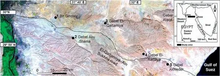
Fig. 1 Landsat Thematic Mapper image of the study area showing the location of the studied sections (1-5).
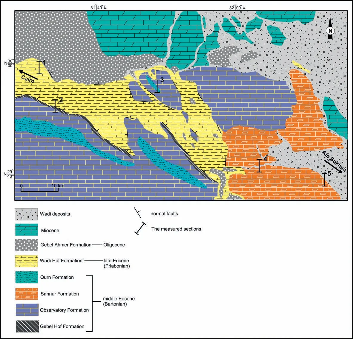
Fig. 2 Geological map of the study area (modified from Said, 1962), with locations of the five measured sections: 1 = Bir Gindaly section;2 = Gebel Abu Shama section; 3 = Gebel Qattamiya section; 4 = Gebel El-Ramliya section; 5 = Gebel Akhieder section.
The study area is characterized by a set of normal faults(with sinuous trends roughly parallel to the rift)that created numerous fault blocks (Said, 1962). The area consists of E-W trending, nearly parallel high scarps, overlooking both sides of the road from Qattamiya to Ain Sukhna, with grabens and half-grabens in-between. The high scarps of the horst blocks are composed mainly of middle Eocene rocks,whereas the areas consisting of grabens and half-grabens are filled with upper Eocene and Oligocene.
The middle-upper Eocene in the northwestern Gulf of Suez was deposited on a carbonate platform, and consists of layered sediments with an inner-shelf facies(e.g, Strougo et al., 1992; Tawfik et al., 2016). The sedimentary succession has been subdivided into three geological formations (Farag and Ismail, 1959;Boukhary et al.,2002).These are,from base to top,the Gebel Hof Formation,the Observatory Formation,and the Qurn Formation. Based on larger benthic foraminifers, Boukhary et al. (2002) assigned these three formations to the Bartonian.The upper Eocene,filling the topographically low areas and grabens,is composed of a shallowing-upward, highly fossiliferous carbonate/siliciclastic succession constituted by the Wadi Garawi and Wadi Hof Formations (Farag and Ismail, 1959;Boukhary et al., 2002). The sedimentation of the overlying continental Oligocene deposits of the Gebel Ahmer Formation was structurally-controlled. This formation, with its substantial thickness (Fig. 2), consists of brightly colored sands and black gravel, and occupies topographically low areas and numerous grabens(Sallam et al.,2015a,b).
3.Material and methods
Five stratigraphic sections of the middle to upper Eocene were measured, sampled and described for their lithology, sedimentary structures and fossil content.The sections are located at Bir Gindaly(~60 m thick), Gebel Abu Shama (~98 m thick), Gebel El-Qattamiya (~125 m thick), Gebel El-Ramliya (~120 m thick), and Gebel Akhieder (~185 m thick) (Fig. 3).Examination of these sections allowed establishing a local lithostratigraphic framework and tracing the local presence of the main formations of the upper Eocene. The age of the latter has been determined precisely on the basis of the biostratigraphic zonation for larger benthic foraminifers(Boukhary et al.,2002).
The present study focuses on sedimentological issues and the micropaleontological datings are therefore compiled from the literature. Generally, the middle-late Eocene successions in the northern part of the Eastern Desert of Egypt yield abundant larger benthic foraminifers with a wide variety of taxa(e.g.,Farag and Ismail,1959;Strougo et al.,1992;Boukhary et al., 2002). According to Boukhary et al. (2002),four local assemblage zones of larger foraminifers(AZ1 through AZ4)can be recognized;they are,from base to top: the Nummulites bartovigatus/Dictyoconus aegyptiensis Assemblage Zone, the Nummulites bullatus/Nummulites aff. pulchellus Assemblage Zone, the Nummulites sp. cf. beaumonti/Nummulites aff. Pulchellus Assemblage Zone, and the Nummulites sp. gr.incrassatus Zone(Fig.3).
Almost a hundred thin sections of collected samples were investigated under a polarizing microscope to determine their lithological composition and textures. Limestone and dolomite textures are described following the classification scheme of Dunham(1962).Several uncovered thin sections have been stained with Alizarin Red-S in order to recognize specific diagenetic features.
Field-based descriptions and laboratory-based lithological analyses provide the information for facies analysis and depositional modeling.Microfacies were identified following the Wilson (1975) model of sedimentary microfacies types (SMF) and facies zones(FZ); these are also compared with the major facies types (MFT) of Nebelsick et al. (2005). The sequence stratigraphical elements are interpreted following the concepts of Van Wagoner et al. (1988), Handford and Loucks (1993), and Catuneanu (2006).
4.Lithostratigraphy
The middle-upper Eocene in the study area consists of the Gebel Hof Formation, the Observatory Formation (and its equivalent, the Sannur Formation,in the eastern part of the investigated area),the Qurn Formation,and the Wadi Hof Formation(Figs.2 and 3).Field descriptions of these formations are presented in the next sections.
4.1. The Gebel Hof Formation
This formation was proposed by Farag and Ismail(1959) to describe an about 120-m-thick section of white limestone alternating with thin bands of hard dolomitic limestone at Gebel Hof in the Helwan area.In the study area,the Gebel Hof Formation is exposed only in the lowermost part of the Gebel Abu Shama section. The contact with the underlying sediments is not exposed. The formation is conformably overlain,with a gradual contact,by the Observatory Formation.
The formation is composed mainly of ~18 m thinbedded grayish-white nummulitic bioclastic limestones.The age of this formation is early Bartonian,as established on the basis of foraminifers by Boukhary et al. (2002).
4.2. The Observatory Formation
This rock unit was introduced by Farag and Ismail(1959) to describe a 80-m-thick section of white to golden-tan, marly and nodular limestones at the Observatory Plateau in eastern Helwan.In the study area,the Observatory Formation conformably overlies the Gebel Hof Formation and is overlain itself conformably by the Qurn Formation (Fig. 4A) or unconformably by the Wadi Hof Formation.In the last case,the Wadi Hof Formation abuts against the Observatory Formation along an E-W trending normal fault plane (Fig. 4B).The Observatory Formation is composed mainly of 40-60 m thin-bedded white to whitish gray limestones and dolomitic limestones with concretions.The age of this formation is Bartonian,as established on the basis of foraminifers by Strougo et al. (1992) and Boukhary et al. (2002).

Fig. 3 Sedimentary logs of the studied sections, showing the distribution of lithofacies and the interpretation of the depositional environments of the middle-upper Eocene in the study area.
In the Gebel El-Qattamiya section, the formation consists of about 60 m of thin-bedded chalky limestones with concretions at its base, and of dolomitic limestones in its middle and upper parts. The middle part is characterized by the common occurrence of chert nodules (Fig. 4C). The biogenic components consist predominantly of larger benthic foraminifers,miliolid foraminifers, abundant bryozoans (Fig. 4D),and bivalves.
In the Gebel Abu Shama section, the formation consists of ~40 m of thin-bedded whitish gray to grayish white bioturbated foraminiferal bioclastic limestones.
4.3. The Sannur Formation
The Sannur Formation was proposed by Boukhary and Abdelmalik (1983) for a 48.4-m-thick shallow reefal carbonate succession in the Nile Valley at the latitude of Beni Suef city.The Sannur Formation is the lateral equivalent of the Observatory Formation in the study area(Osman,2003;Sallam et al.,2015a,2018a).It is exposed in the eastern part of the study area, in both the Gebel El-Ramliya and Gebel Akhieder sections. The age of this formation is Bartonian, as established on the basis of foraminifers by Boukhary and Abdelmalik (1983).
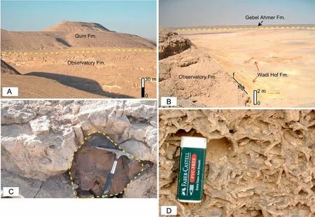
Fig. 4 General view and characteristics of some of the formations. A) The Observatory Formation is conformably overlain by the Qurn Formation in the Gebel El-Qattamiya section; B) The Observatory Formation is unconformably overlain by the Wadi Hof Formation along an E-W trending normal fault plane (f) in the Gebel El-Qattamiya section; C) Chert nodules (circled by a dashed line) in limestones of the Observatory Formation in the Gebel El-Qattamiya section; hammer (26 cm) for scale. D) Bryozoan limestone in the upper part of the Observatory Formation in the Gebel El-Qattamiya section; eraser (~7 cm) for scale.
In the Gebel El-Ramliya section, the Sannur Formation is composed of ~120 m of thin-bedded, bioturbated, white to earthy gray chalky limestones. In the Gebel Akhieder section,the 175-m-thick formation consists at its base predominantly of thick-bedded earthy gray to grayish white algal bioclastic dolomitic limestones, and at its top of bioturbated bryozoan foraminiferal chalky limestones(Fig.5A and B).Chert nodules are also common in this section.
4.4. The Qurn Formation
The Qurn Formation was proposed by Farag and Ismail (1959) in the Qurn area in eastern Helwan, in their description of a~97-m-thick section of chalky and marly limestones alternating with sandy marls. In the study area,the Qurn Formation is exposed in both the Gebel El-Qattamiya and the Gebel Abu Shama sections. It conformably overlies the Observatory Formation and is unconformably overlain itself by the Wadi Hof Formation.The age of this formation is Bartonian,as established on the basis of foraminifers by Boukhary et al. (2002).
The lower part of the formation is composed of about 15-20 m thin-bedded yellowish marly fossiliferous (mollusks) white to pale yellow limestones,whereas the upper part consists mainly of ~15 m of chalky white nummulitic bioclastic limestones.
4.5. The Wadi Hof Formation
The Wadi Hof Formation, first described by Farag and Ismail (1959) from the Wadi Hof in the Helwan area, is stratigraphically equivalent to the Maadi Formation in the Greater Cairo area (Said, 1962), and it fills the graben areas along the road from Qattamiya to Ain Sukhna. The formation unconformably overlies either the Qurn Formation or the Observatory Formation and is,in turn,also unconformably overlain by the Oligocene continental Gebel Ahmer Formation(Fig.6).The age of the Wadi Hof Formation is Priabonian, as established on the basis of foraminifers by Boukhary et al. (2002).

Fig. 5 General view of the Sannur Formation. A) In the Gebel El-Ramliya section; truck (~3.5 m high) for scale; B) In the Gebel Akhieder section; person (1.70 m tall) for scale.
The thickness of the Wadi Hof Formation is highly variable,from approx.60 m in the Bir Gindaly section to 35-20 m in the Gebel El-Qattamiya and Gebel Abu Shama sections. Eastwards, the thickness of the formation decreases to 10-15 m in the Gebel El-Ramliya and Gebel Akhieder sections. The abrupt vertical and lateral facies changes of the Wadi Hof Formation suggest syn-sedimentary faulting and local variations in sediment supply (Sallam et al., 2015a; Haggag, 2016).Accumulation of the formation took place most probably during a faulting phase(the Pyrenean-Atlasic tectonics)that was initiated at the beginning of the late Eocene (Guiraud, 1986; Guiraud et al., 2001; Issawi et al., 2009; Haggag, 2016); consequently, the formation is an example of syn-tectonic sedimentation(Haggag, 2016). This also explains the differences in thicknesses of the formation throughout the study area.
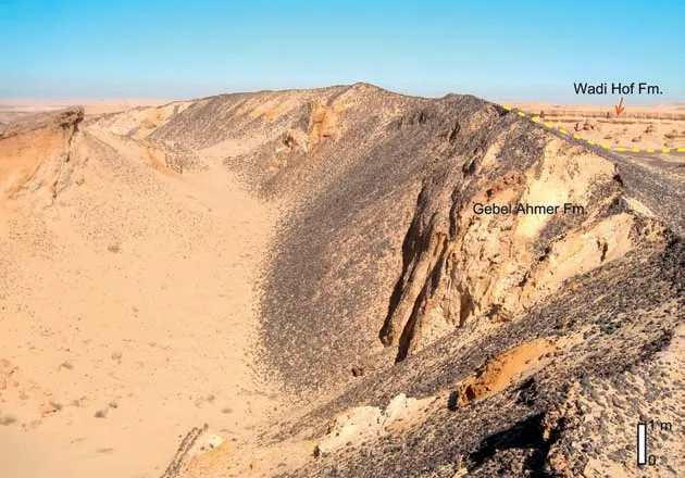
Fig. 6 Sand and gravel deposits of the Oligocene Gebel Ahmer Formation overlying the Eocene Wadi Hof Formation in the Gebel El-Qattamiya section.
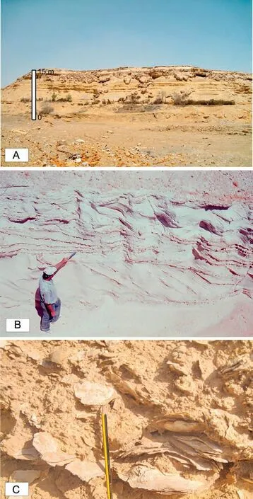
Fig. 7 Characteristics of the Wadi Hof Formation. A) General view of the formation in the Bir Gindaly section; B) Large-scale crossbedded sandstones overlain by small-scale cross-bedded sandstones and siltstones in the Bir Gindaly section; person (1.60 m tall) for scale;C)Carolia-bearing layer in the upper part of the formation in the Gebel El-Qattamiya section; pencil (12 cm) for scale.
Throughout the sections,the Wadi Hof Formation is composed mainly of mixed carbonate/siliciclastic sediments containing several mollusk-rich beds and thin phosphate-containing layers with shark teeth.The sediments are tarnished yellow to yellowish brown,which contrasts with the underlying earthy gray and chalky white foraminiferal limestones of the middle Eocene formations. In the Bir Gindaly section, the lower part of the Wadi Hof Formation consists of~40 m of thick-bedded brownish-yellow fossiliferous marly limestones and dolomites,alternating with pale yellow mollusk coquinas and yellowish-brown to brownishyellow sandy fossiliferous marlstones with concentrations of oyster shells and nummulitic limestones. This succession is followed upwards by ~15 m of thick,laminated greenish-gray gypsiferous shales that alternate with cross-bedded sandstones (Fig. 7A-B),siltstones and marlstones. It is covered by ~5 m of fossiliferous marly limestones with a rich macrofauna (Fig. 7C) alternating with sandy siltstones and sandstones.
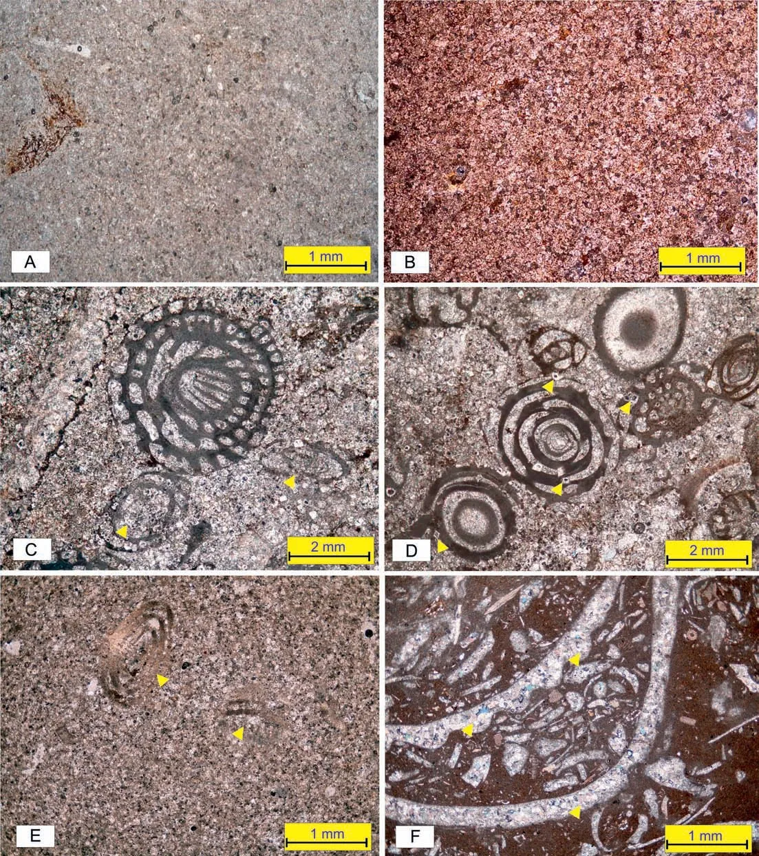
Fig.8 Facies association 1:tidal flat and shallow subtidal marine facies.A)Lime-mudstone(lithofacies LF1)of the Sannur Formation(Gebel Akhieder section),consisting of barren homogeneous micrite;B)Dolomicrite(LF2)of the Observatory Formation(Gebel El-Qattamiya section)showing a hypidiotopic fabric with equidimensional grains; C-E) Foraminiferal dolomites (LF3) from the Observatory Formation (Gebel El-Qattamiya and Gebel Abu Shama sections) with partially or completely dolomitized large benthic foraminifers and miliolids (see yellow arrows); F) Sandy bioclastic rudstone (LF4) of the Wadi Hof Formation (Bir Gindaly section) with oyster shell fragments within a micritic matrix; the shells show aggrading neomorphism (yellow arrows).
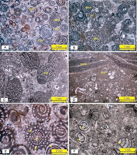
Fig.9 Facies association 2:restricted shelf and lagoonal setting.A-D)Miliolid foraminiferal pack-to grainstones(lithofacies LF6)from the Observatory and Sannur Formations (Gebel El-Qattamiya, Gebel El-Ramliya and Gebel Akhieder sections); the sediments consist largely of miliolid foraminifers including Pseudolacazina (pse), Biloculina (bil), Triloculina (tri) and Quinqueloculina (qui), large benthic foraminifers including Dictyoconus(dic),Somalina(som)and Idalina(ida),and minor algae;all fossils are embedded in a microsparitic to micritic matrix;E-F)Chambers of miliolid foraminifers filled by cement material(microsparite;yellow arrows)from the Sannur Formation(Gebel El-Ramliya section).
5.Facies associations and depositional environments
Twelve lithofacies (LF1 through LF12) are distinguished on the basis of thin-section analysis.These lithofacies are represented by packages of lime-mudstones,wackestones, packstones, pack-to grainstones, grainstones, rudstones, boundstones and dolomites, and they can be grouped,on the basis of genetically related lithofacies,into four facies associations that represent,respectively, tidal flats and shallow subtidal facies(FA1), a restricted shelf and lagoon (FA2), shoal bars(FA3),and an outer-shelf lagoon with reefs(FA4).
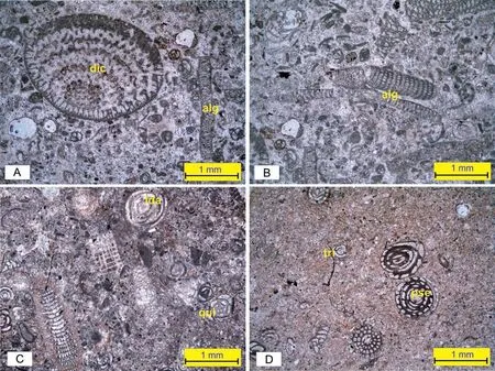
Fig.10 Facies association 2:restricted shelf and lagoonal setting.A-B)Algal foraminiferal packstone(LF7)from the Observatory Formation(Gebel El-Qattamiya section) consisting of large benthic foraminifers including Dictyoconus (dic), algal debris (alg) and small miliolid foraminifers embedded in a microsparitic matrix; C) Bioclasts including Idalina (ida) and Quinqueloculina (qui), and Rhabdorites with micrite envelopes from the Sannur Formation (Gebel El-Ramliya section); D) Foraminiferal wackestone (lithofacies LF8) from the Observatory Formation (Gebel El-Qattamiya section) with miliolid foraminifers scattered within a microsparitic to micritic matrix.
The various facies associations developed in a downslope shallow-marine setting on an inner carbonate ramp. The characteristics of the facies associations are presented in Table 1.

Fig.11 Faciesassociation3:shoalbars.Miliolidforaminiferalpeloidal grainstones (lithofacies LF9) from the Sannur Formation (Gebel Akhieder section);the particles are cemented by sparry calcite.
5.1. Facies association 1
This facies association (FA1) dominates the middle and upper parts of the Observatory Formation in the Gebel Abu Shama and Gebel El-Qattamiya sections,and is represented by 2-6 m of dolomitic limestones.It also occurs in the lower part of the Sannur Formation in the Gebel Akhieder section, where it consists of 3-5 m of mudstones and massive, dark gray foraminiferal dolostones. Moreover, it forms the lower and upper parts of the Wadi Hof Formation in the Bir Gindaly and Gebel El-Qattamiya sections, where it is composed mainly of 40 m of marly limestones and dolomites, alternating with coquinas and sandy marlstones with shell beds. This is followed by 15 m of laminated shales alternating with cross-bedded sandstones and siltstones,overlain by a 5-m-thick Caroliabearing limestone layer.
5.1.1. Description
FA1 comprises five lithofacies: lime-mudstone(LF1), dolomicrite/dolosparite (LF2), foraminiferal dolomicrite(LF3),sandy bioclastic rudstone(LF4)and laminated gypsiferous shales (LF5).
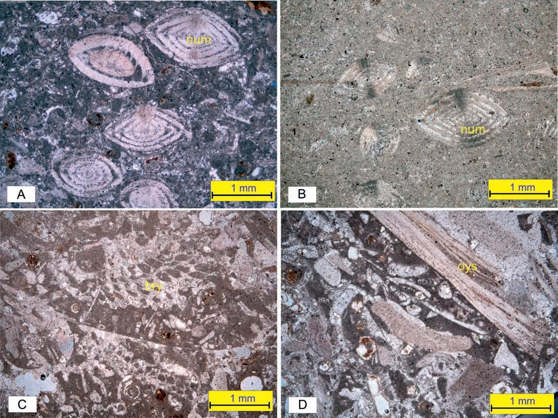
Fig. 12 Facies association 4: open shelf lagoon with reefs. A- B) Nummulitic wacke- to packstones (lithofacies LF10) from the Qurn Formation(Gebel El-Qattamiya section)and the Sannur Formation(Gebel Akhieder section)with nummulite tests(num)embedded in a micritic matrix;C)Bryozoan rudstone(LF11)from the Observatory Formation(Gebel El-Qattamiya section)consisting of bryozoan fragments(bry)in addition to a few miliolid foraminifers and quartz grains embedded in a micrtitic matrix; D) Bioclastic rudstone (LF12) from the Qurn Formation (Gebel Abu Shama section) consisting of bioclasts that are represented by oyster (oys) shell fragments, echinoids, gastropods and a few large foraminifers.
LF1 is composed of homogeneous barren micrite(Fig.8A).LF2 consists mainly of euhedral to subhedral dolomite rhombs ranging in size from 20 μm (dolomicrite) to 130 μm (dolosparite). Most of the dolomite rhombs have a hypidiotopic fabric with an equigranular texture (Fig. 8B). The crystals tend not to show zonation, but the cores are cloudy, whereas their outer parts are clear. A few dolomite rhombs show zoning,however, with brownish cores and thin, clear outer rims. LF3 is in most respects similar to LF2, but contains biogenic components, mostly large benthic foraminifers and miliolids that are partially or completely dolomitized(Fig.8C-E).LF4 consists mainly of oyster fragments, gastropods, and minor nummulites that show aggradation by neomorphism and that are embedded in a micritic ground mass (Fig. 8F). LF5 is composed mainly of laminated gypsiferous shales with small cross-bedded sandstones, siltstones and marlstone intercalations.
Dolomitization is the most common diagenetic feature characterizing FA1.It took place mainly during late diagenesis and is commonly linked to hypersaline brines in a tidal flat (Keheila and El-Ayyat, 1992).
5.1.2. Interpretation
FA1 is comparable with the SMF12 and SMF23 facies of Wilson's (1975) model, which facies are ascribed to sedimentation in transitional, marginal-marine environments, particularly in tidal flats (facies zones FZ8 and FZ9) and in shallow subtidal zones (FZ7). FA1,which dominates the mixed carbonate/siliciclastic sediments of the Wadi Hof Formation, is therefore interpreted to represent a transition from the shallowmarine shelf and lagoonal/reefal carbonate setting of the underlying Observatory, Sannur and Qurn Formations to the continental setting of the overlying Gebel Ahmer Formation.
The lime-mudstones and dolomicrites (SMF23 of the Wilson model) with a very restricted fauna are interpreted to represent peritidal deposits formed in tidal flats(FZ8)and along arid evaporitic coasts(FZ9A)during a short phase of sea-level fall and a syndepositional replacement of a previously-formedlime-mudstone (cf. Tucker and Wright, 1990; Keheila and El-Ayyat, 1992; Afify et al., 2016; Ruban et al.,2019; Sallam et al., 2019a). Oyster shell beds (sandy bioclastic rudstones: LF4) were formed in the central part of a platform area that included restricted platforms, beaches (foreshore) and tidal flats (FZ8) (cf.Flügel, 2010). Shell beds are represented by Wilson's(1975) SMF12, which he interpreted to have formed in a normal marine, low-energy, shallow subtidal environment on a platform (see also Issawi et al.,2005; Sallam et al., 2018b).
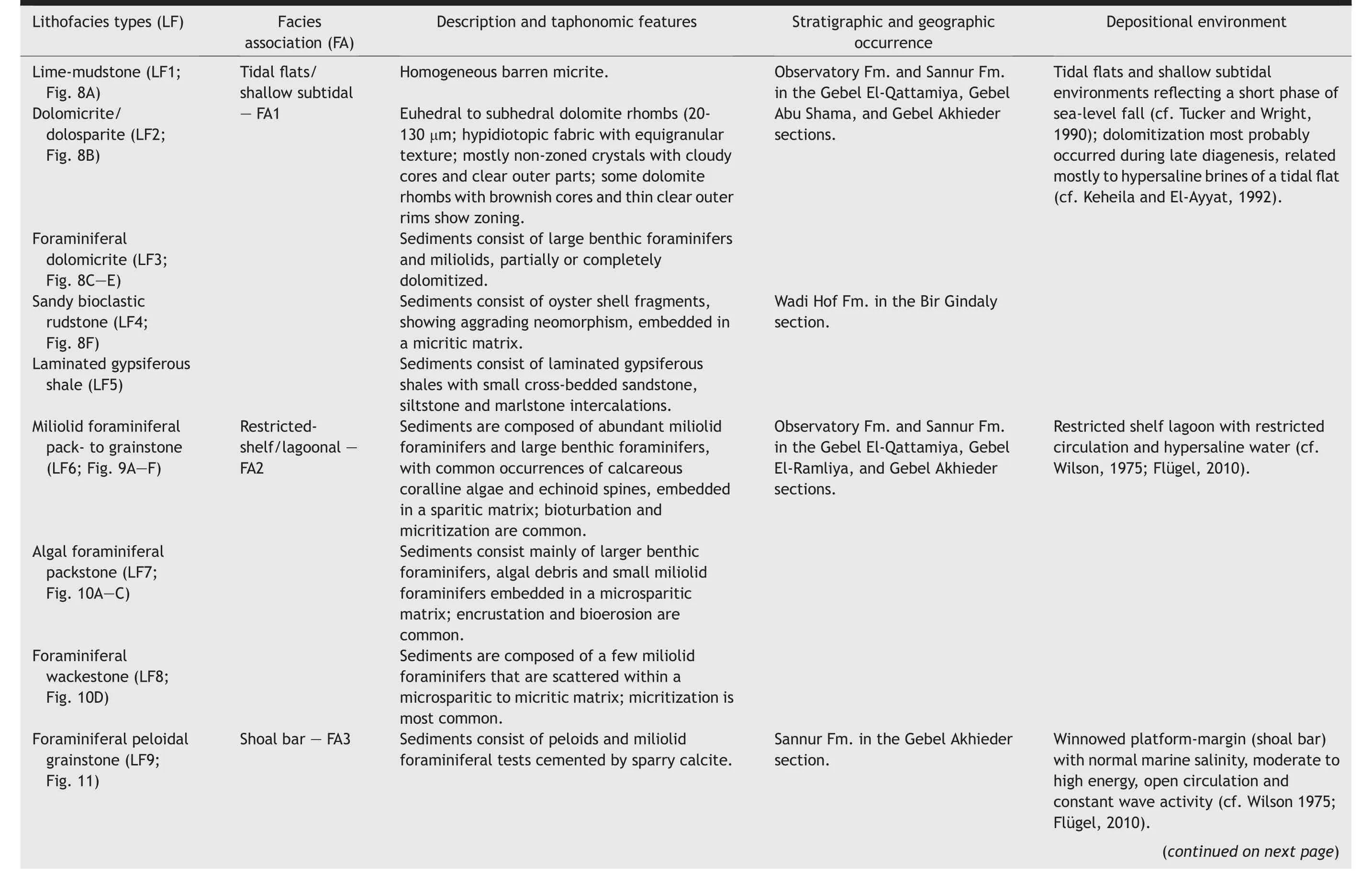
Table 1 Lithofacies types, characteristics and depositional environments.
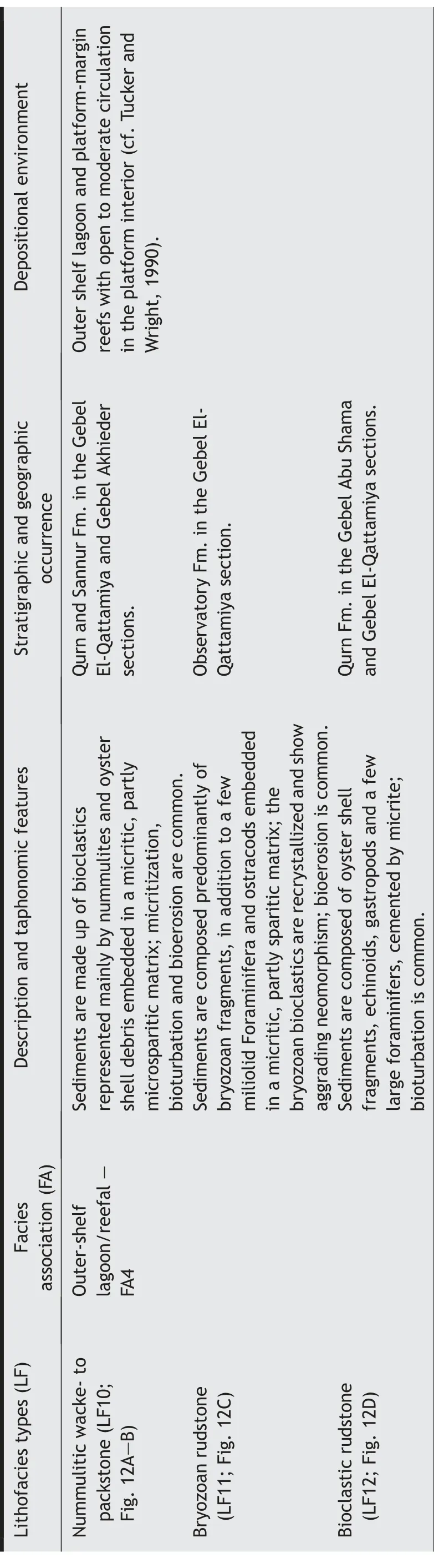
Table 1 - (continued)
The fossils form packstone and rudstone fabrics.Most shell concentrations developed during a phase of sea-level rise (cf. Fürsich and Oschmann, 1993). The Carolia shell beds in the upper part of the Wadi Hof Formation were formed, most probably, in a brackish nearshore environment (Carbonel and Pujos, 1981).The laminated gypsiferous shales with cross-bedded sandstone and siltstone intercalations in the upper part of the Wadi Hof Formation indicate deposition in a nearshore environment with a commonly high terrigenous input, most probably a peritidal flat environment with low-energy conditions(cf. Flügel, 2010).
On the basis of the above characteristics and considerations, deposition of FA1 is interpreted to have taken place in tidal flats and shallow subtidal environments in the central part of a carbonate platform where strong tidal currents were present.
5.2. Facies association 2
FA2 dominates the lower part of the Observatory Formation in the Gebel Abu Shama and Gebel El-Qattamiya sections, and the middle and uppermost parts of the Sannur Formation in the Gebel El-Ramliya and Gebel Akhieder sections. In the former two sections,FA2 consists of about 40 m of thin-bedded algalforaminiferal bioturbated white to earthy gray chalky nodular limestones, whereas it is composed in the latter two sections of about 98 m of thick-bedded grayish-white and whitish-gray bioturbated chalky foraminiferal-algal limestones.
5.2.1. Description
FA2 consists of miliolid foraminiferal pack- to grainstones (LF6), algal foraminiferal packstones(LF7), and foraminiferal wackestones (LF8). Cementation, micritization, recrystallization and chertification are the most common diagenetic features of FA2.
The miliolid foraminiferal pack- to grainstones(LF6) are characterized by abundant miliolids and larger benthic foraminifers with common occurrences of calcareous coralline algae and echinoid spines(Fig. 9A-D). Some of the bioclasts show aggrading neomorphism. The chambers of some miliolids are filled with a cement of microsparry calcite (Fig. 9E-F).
The algal foraminiferal packstone microfacies(LF7) consists mainly of larger benthic foraminifers,algal debris and small miliolid foraminifers that are embedded in a micritic to microsparitic matrix(Fig. 10A and B). Some bioclasts show micritization and/or micrite coating (Fig. 10C), and patchy neomorphism is present in the micritic matrix.
The foraminiferal wackestone(LF8)is composed of a few miliolid foraminifers that occur scattered throughout the microsparitic to micritic matrix(Fig. 10D).
5.2.2. Interpretation
The sediments of FA2 have much in common with Wilson's (1975) SMF18 microfacies (bioclastic grainstones and packstones with abundant or calcareous algae). It is typically similar to zone FZ8 (platform interior-restricted). FA2 also corresponds to microfacies MFT10 (smaller miliolid facies) and MFT7 (small nummulites facies) of Nebelsick et al. (2005). Consequently, we interpret FA2 to represent a shallow lagoon and bays on a restricted platform, with restricted circulation and hypersaline water (cf.Wilson,1975; Flügel, 2010).
SMF18 occurs on sandy shoals aggraded by tidal currents in shallow lagoons(restricted inner platform,FZ8) (Wilson, 1975; Flügel, 2010). Shallow nearshore and central lagoonal environments on the platform down to about 50 m are characterized by abundant miliolid foraminifers and calcareous algae (Hottinger,1997) and by a low to moderate fossil diversity. Miliolid foraminifers prefer low turbulence and soft substrates, and the presence of abundant specimens indicates a restricted lagoonal environment or sheltered bays of low energy and high salinity (Hottinger,1997; Geel, 2000). This is consistent with the fact that abundant miliolid foraminifers, calcareous algae and ostracods characterized protected bays on the Tethyan Cenozoic shallow carbonate platforms(Hallock and Glenn, 1986; Buxton and Pedley, 1989;Hottinger,1997,Serra-Kiel et al.,1998;Scheibner and Speijer, 2009; Sallam et al., 2019a, b).
The cement of the various carbonates consists of sparry calcite. Micritization took place commonly due to the action of boring organisms,leading during early diagenesis to the formation of a patchy micrite and micrite envelopes (Sallam and Ruban, 2020). Recrystallization is indicated by the growth of calcite crystals(aggrading neomorphism), filling intraparticle pores.The chert nodules were formed most probably during early diagenesis by replacement of carbonates by silica(e.g.,Noble and Van Stempvoort,1989).In the shallowmarine settings that FA2 represents,chert nodules are often related to mixing zones(Laschet,1984).
FA2 is very similar to that of the lithofacies described from middle and upper Eocene carbonates at different localities in NE Egypt (e.g., Stefan et al.,2011; El-Ayyat, 2013; Sallam et al., 2015b).
5.3. Facies association 3
FA3 dominates the middle part of the Observatory Formation in the Gebel Abu Shama and Gebel El-Qattamiya sections, and the upper part of the Sannur Formation in the Gebel Akhieder and Gebel El-Ramliya sections.
5.3.1. Description
The deposits of this facies association consist mainly of grayish foraminiferal sandy bedded limestones. Microscopically, FA3 appears to consist mainly of mud-free, well-sorted foraminiferal peloidal grainstones (LF9) with bioclasts that are cemented by sparry calcite (Fig. 11). Some bioclasts show micrite envelopes, while some other ones display aggrading neomorphism and are filled with sparite.
5.3.2. Interpretation
The sediments of FA3 correspond to the SMF11 microfacies (coated bioclastic grainstones with sparry cement) of Wilson (1975) and the MFT10 microfacies(small miliolid facies)of Nebelsick et al.(2005),which suggests deposition on a winnowed platform margin(barrier shoal; FZ6) with normal marine salinity,moderate to high current energy, and constant wave action (Wilson, 1975; Flügel, 2010). It is known that peloids like those in FA3 occur preferentially in very shallow environments. The good sorting and rounding of the biogenic components, as well as the sparry cement of the limestones indicate frequent reworking by waves and tidal currents (Dunham, 1962).
5.4. Facies association 4
FA4 is present in the Gebel Hof Formation in the Gebel Abu Shama section, where it consists of about 18 m of thin-bedded gray to grayish-white sandy nummulitic limestones. This facies association also occurs in the middle and upper parts of the Observatory and Sannur Formations in the Gebel Abu Shama,Gebel El-Qattamiya, Gebel El-Ramliya and Gebel Akhieder sections,where it consists mainly of 10-25 m of thick-bedded dark gray to brownish-gray, hard,siliceous bryozoan limestones. Moreover, FA4 also constitutes the lower and upper parts of the Qurn Formation in the Gebel Abu Shama and Gebel El-Qattamiya sections, where it consists of about 15-20 m of thin-bedded yellowish marly fossiliferous white to pale yellow limestones with oysters, bryozoans and very rare foraminifers and ostracods, followed upwards by about 15 m of thick-bedded chalky limestones and marlstones rich in nummulites and echinoid spines,with minor occurrences of bryozoans,gastropods and oysters.
5.4.1. Description
FA4 comprises three lithofacies:nummulitic wcketo packstones(LF10),rudstones(LF11),and burrowed rudstones (LF12), all with abundant bioclastic components.
The nummulitic wacke- to packstones (LF10) are composed of bioclasts represented mainly by nummulites and oyster shell debris,with minor amounts of quartz grains (Fig. 12A and B). All are embedded in a micritic matrix, partly microsparitic.
The bryozoan rudstones (LF11) consist predominantly of bryozoan fragments, with a few miliolid foraminifers, ostracods and quartz grains embedded in a micritic,partly sparitic,matrix.The bryozoan bioclasts are recrystallized, showing aggrading neomorphism,where the micrite is transformed into sparry calcite(Fig.12C).
The bioclastic rudstones (LF12) consist of bioclasts that are represented by oyster shell fragments, echinoids,gastropods and a few large foraminifers cemented by micrite(Fig.12D).
5.4.2. Interpretation
FA4 is quite similar to the SMF8 (wackestones and boundstones with complete fossils and well-preserved infauna and epifauna), SMF9 (burrowed bioclastic wackestones/rudstones), and SMF10 (bioclastic packstones and grainstones with coated and abraded skeletal grains) facies of Wilson (1975). It also resembles the FZ5 (platform-margin reefs) and FZ7 (platform interior-open marine)facies zones.The sediments of FA4 can also be compared with the MFT6 (large nummulites facies) and MFT14 (bryozoan facies) of Nebelsick et al. (2005).
We interpret FA4 consequently to represent an outer-shelf lagoon and platform-margin reefs. The bryozoan rudstones (LF11) suggest deposition as platform-margin reef talus(FZ5)in a warm,low-energy environment (cf. Wilson, 1975; El-Safori et al., 1997;Flügel,2010).The common occurrence of ostracods in this facies association also indicates sedimentation in a shallow-marine environment (Whatley, 1983;Brouwers,1988;Bassiouni et al.,1994).The sediments of FA4 with its shallow-water sessile organisms, large benthic foraminifers (commonly nummulites), bryozoans and mollusks are consequently interpreted to represent outer-shelf lagoonal and reefal environments with active to moderate currents.
6.Sequence stratigraphy
In terms of sequence stratigraphy, the sediments form a relatively conformable succession of genetically-related lithofacies types (cf. Golonka and Kiessling, 2002; Catuneanu, 2006, 2019; Catuneanu et al., 2009). The middle-upper Eocene in the northwestern Gulf of Suez under study here consists almost entirely of one third-order depositional sequence.This sequence is bounded at its base and top by sequence boundaries SB1 and SB2,respectively.SB1 is not exposed in the study area,but SB2 is represented by the erosional unconformity between the late Eocene Wadi Hof Formation and the overlying Oligocene Gebel Ahmer Formation,which marks the abrupt change from the marginal-marine,tidal-flat sediments of the Wadi Hof Formation to the continental (fluvial)sediments of the Gebel Ahmer Formation with vividly colored sands and black gravels resulting from the tectonic uplift(the Red Sea Mountains)during the late Eocene-early Oligocene (Omar and Steckler, 1995).
The sequence consists of two genetically-related packages of system tracts, namely a transgressive systems tract (TST), and a highstand systems tract (HST)(Fig.13).The TST typifies the retrogradation that took place during the middle Eocene (Bartonian) sea-level rise. The TST succession consists of inner- and outershelf lagoonal and reefal, miliolid foraminiferal packto grainstones, algal foraminiferal packstones, nummulitic bioclastic pack- to grainstones, and bryozoan rudstones.The maximum flooding surface(mfs)occurs at the top of the TSTand is represented by nummulitic wacke- to packstones and bryozoan rudstones, and miliolid foraminiferal pack to grainstones of the lagoonal and reefal facies. During the late Eocene(Priabonian), aggradation led to the HST, which is represented by tidal-flat and shoal sediments consisting of dolomicrites/dolomicrosparites,lime-mudstones and peloidal grainstones. These HST facies indicate a relative sea-level highstand above the maximum relative sea-level rise of the underlying sediments that represent the TST. The HST is overlain by an LST(formed by sediments that represent progradational facies), which corresponds to the fluvial sand and gravels of the Gebel Ahmer Formation that were deposited during sea-level fall.
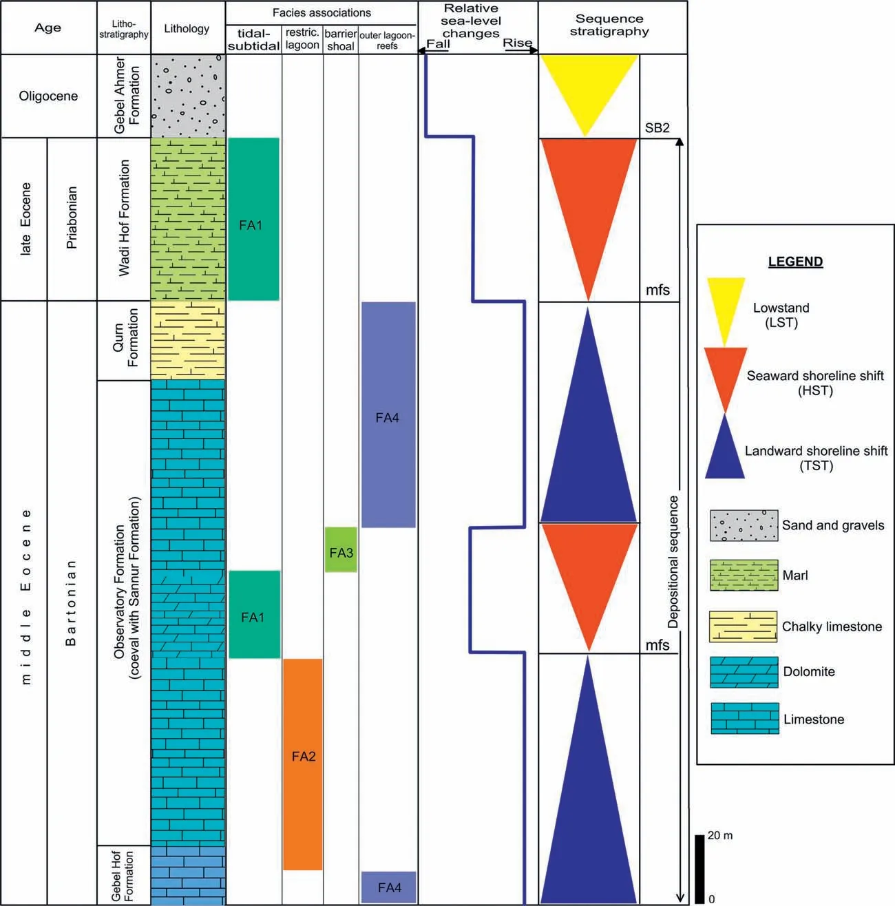
Fig. 13 Sequence architecture and systems tracts of the middle-late Eocene succession under study. Abbreviations: SB = sequence boundary, TS = transgressive surface, mfs = maximum flooding surface, LST = lowstand systems tract, HST = highstand systems tract,TST = transgressive systems tract (see Fig. 3 for fossil symbols).
7.Depositional model
A combination of data from previous field studies,our own microfacies analysis based on thin sections,and our sequence-stratigraphic analysis allows a sound interpretation of the depositional conditions,including the interpretation of facies belts and their shifting in time.
It appears that the succession under study, which dates from the middle to late Eocene,consists mainly of four genetically-related facies associations (FA1 through FA4).The composition and textural characteristics of these facies associations suggest sedimentation in shallow-marine environments that extend from tidal flat to restricted lagoon and shoal bars to outer-shelf lagoon and reefal carbonate environments (Fig. 14).Thus, these facies associations jointly represent a shallow carbonate shelf setting.
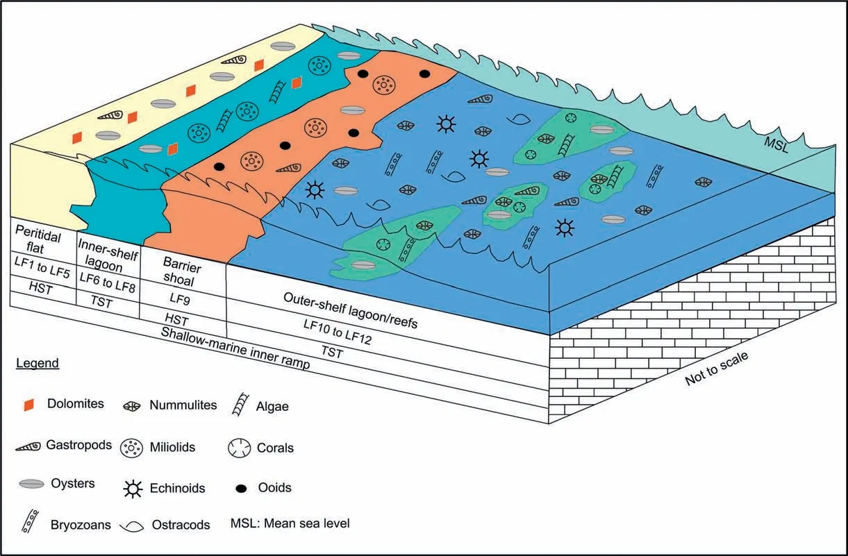
Fig. 14 Schematic depositional model of the shallow carbonate shelf of the middle-upper Eocene in the study area.
8.Discussion
An important question when interpreting depositional environments is always whether the conclusions are consistent with the larger geological framework.Guiraud et al. (2001, 2005) and Golonka (2004) have provided the best overviews of the geological evolution of NE Africa,including the study area.They state that the region was occupied by an extensive marine basin that was a marginal part of the Eastern Mediterranean (this was a remnant of the Tethys, but it should not be confused with the Neo-Tethys). A sea covered the northern surroundings of Africa and Arabia(a single continental block until the Oligocene) and penetrated the continent's interior through elongated tongues (Fig. 15). The study area was located in the center of this basin, where a carbonate shelf was present. The basin underwent a slight regression during the mid-Paleogene, but was significantly reduced in size only during the Oligocene, when the shoreline shifted northwards. Fluvial deposition then started in the study area (Shukri and Akmal,1953).
On the basis of the above geological framework,it must be deduced that the findings presented in the present study fit well within the overall structure,and that they present a more detailed insight into the regional development of NE Africa. Even being so, it seems only appropriate to discuss how the findings relate to the known more global eustatic sea-level fluctuations, and in how far the findings are consistent with the present-day ideas about the distribution of land and sea in the study area. These aspects are discussed in Sections 8.1 and 8.2., respectively.
8.1. Regional versus global sea-level fluctuations
The stratigraphical relationships between the various facies associations in the study area allow, in combination with the sequence stratigraphic interpretations,reconstruction of the regional sea-level changes(Fig. 13). The sea level remained mostly high during the Bartonian, with two peaks marked by maximum flooding surfaces. Regression started in the Priabonian and culminated in the Oligocene when terrestrial conditions prevailed in the study area (regressions and erosional surfaces are also known from the adjacent regions - e.g., Guiraud et al., 2005).

Fig. 15 Paleogeographical setting of the study area in the mid-Eocene. Reconstruction simplified from Guiraud et al. (2005) and slightly adjusted after Golonka (2004).
The above-mentioned regional sea-level changes characterized the very edge of NE Africa, i.e., the southern, generally passive margin of the Eastern Mediterranean.Indeed,some analogues of them can be found on the better-known northern margin of this basin.For instance,a late Eocene local regression and interruption of the sedimentation during the Oligocene have been reported from SW France(Courme-Rault and Dubar, 2011), northern Italy (Trevisani and Papazzoni,1996), Turkey (¨Onal and Kaya, 2007; Boulton, 2009),and Greece (Maravelis and Zelilidis, 2011). However,one should take into account the tectonic activity of the northern periphery of the Eastern Mediterranean(e.g.,Golonka,2004)and the differences between this regime and that of the study area. This is why similarities and differences of the regional sea-level changes may be only incidental and do not necessarily indicate any common, global-scale eustatic events. Consequently, rather the available global eustatic curves should be used for discussion of the possible global controls of the events in the study area.
The regional sea-level changes (Fig. 13) can be assessed by comparison with the known global sealevel changes, even though the latter are reconstructed in different ways and have been interpreted somewhat differently(Plyusnina et al.,2016).Such an assessment shows a good correspondence of the regional sea-level changes found by us with the eustatic fluctuations outlined by Haq and Al-Qahtani(2005), who updated the earlier work by Haq et al.(1987). The mid-Bartonian and Bartonian/Priabonian sea-level highs that we found have obvious equivalents on the global eustatic curve, which indicates that the Priabonian and early Oligocene global sea-level fluctuated,but tended to fall.This is consistent with what we established for the study area where,nonetheless,the sea-level fall was significantly more pronounced.
The alternative reconstruction by Kominz et al.(2008), who updated an earlier version (Miller et al.,2005), implies that the global sea level would commonly be slightly lower in the Bartonian than in the Priabonian (this global curve does not permit judgments of changes exactly at the stage boundary), and that it dropped significantly only in the early Oligocene. The correspondence between our regional findings and the global changes as indicated by Kominz et al. (2008) is weak for this time-span. However, the reconstruction by Haq and Al-Qahtani(2005)should be favored as it is based on a global synthesis of the eustatic data, whereas the curve of Kominz et al.(2008) is based only on data obtained for the New Jersey margin of North America; these data may have been influenced significantly by regional tectonic activity. It must consequently be deduced that the good correspondence between the sea-level changes in our study area(Fig.13)and the global eustatic fluctuations(Haq and Al-Qahtani, 2005) indicates a significant eustatic control of the sedimentation in our study area.
Although the Eocene/Oligocene boundary is marked by global-scale environmental perturbations (Zachos et al., 2001; Ravizza and Peucker-Ehrenbrink, 2003;Merico et al., 2008; Goldner et al., 2014; Gallagher et al., 2020), these were relatively short-term and the sea level was mostly high during the entire Priabonian-Rupelian (Plyusnina et al., 2016). Most probably, the tectonic activation of NE Africa and the regional uplift preceding the opening of the Red Sea rift system (Bosworth et al., 2005; Guiraud et al., 2005;Almalki et al.,2015;Bosworth and Stockli,2016 Segev et al., 2017), coupled with the long-term trend of eustatic fall (Haq and Al-Qahtani, 2005), were able to cause the local Priabonian regression. The regional paleogeographic reconstructions by Golonka(2004)and Guiraud et al.(2005)confirm this scenario.
8.2. Hypothesizing land mass affinity
An intriguing question regards the land masses near which the lagoonal carbonate deposition took place.The present study implies a relatively nearshore position of the study area not only before the regional uplift, but also earlier, in the mid-Eocene (Bartonian)(Fig. 13). If so, to which land mass did the shore belong? This question is sensible because the study area is interpreted to have been located in the center of an extensive shelf.
Three alternative explanations are possible considering the general paleogeographic setting of the study area (Fig. 15). First, both Golonka (2004) and Guiraud et al. (2005) indicated active tectonics in NE Africa during the Eocene that could be associated with local uplifts and small islands. Second, the hypothesized land mass may have been a relatively large territory so that its northern shore may well have stretched to near the study area. Third, the riftingrelated uplift may have started earlier than commonly assumed; the sea was shallow, and even moderate vertical motions must have been enough to create or increase a land mass.
Further investigations are needed to find out which of these hypotheses is correct, but we think that the first one is the most probable.We think so,because it has been proven that open-marine conditions occurred even much farther southward than the study area(Abdel-Fattah et al., 2010); moreover, the riftingrelated uplift started in the Oligocene (Omran and El Sharawy, 2014). The presence of islands thus is the most feasible explanation.
9.Conclusions
The Bartonian-Priabonian deposits in the northwestern Gulf of Suez are placed in a logical lithostratigraphic framework. This provides a new depositional model, which fits well in the known overall geological setting of NE Africa. The lithostratigraphic characteristics concern the Gebel Hof, Observatory,Sannur, Qurn, and Wadi Hof Formations. The deposits of these formations can, on the basis of a detailed litho-facies analysis, be grouped into four facies associations that represent specific marine (tidal flat to outer shelf) environments that form roughly parallel belts on a wide carbonate shelf. The sea level fluctuated regionally with two peaks in the Bartonian and a pronounced fall in the Priabonian-early Oligocene.Global eustatic processes controlled the peaks in the Bartonian, whereas tectonics facilitated the eustatic control of the sea-level fall in the Priabonian. Additionally, significant paleogeographic re-organizations at the very Eocene-Oligocene transition are hypothesized, but the spatio-temporal relationship between rifting-related and other tectonically-induced phases of uplift need further investigation.
The present contribution focuses on sedimentological issues, including the sequence stratigraphy.Future studies should pay additional attention to foraminiferal paleoecology and taphonomy of the Bartonian-Priabonian deposits in the study area.Such studies might validate or (less likely) falsify the depositional model shown in the present contribution.
Acknowledgements
We gratefully thank the journal's editors and the reviewers for their support and valuable comments,which helped to improve this study.
杂志排行

Journal of Palaeogeography的其它文章
- Giant ooids of microbial origin from the Zhangxia Formation (Cambrian Miaolingian Series) in North China
- Bioturbation enhanced petrophysical properties in the Ordovician carbonate reservoir of the Tahe oilfield, Tarim Basin, NW China
- Book Review on River Planet:Rivers from Deep Time to the Modern Crisis by Martin Gibling
- Palaeoenvironmental reconstruction for the Permian (lower Gondwana) succession of the Godavari Valley Coalfield in southern India based on a combined palynofacies, carbon isotope, and biomarker study
- Middle Jurassic climate oscillations from paleosol records of the Sichuan Basin,SW China
- Silurian ostracods from the Nyalam region,southern Tibet,China and their implications on palaeoenvironment and palaeobiogeography