Influence of Intensity of Rain Strains and Slopes on the Development of Soil Erosion under the Forest
2021-01-19RadikMustafinRidaSultanovaLuizaKhasanovaAnzhelikaRajanovaAigulKhazipova
Radik F.Mustafin,Rida R.Sultanova,Luiza M.Khasanova,Anzhelika R.Rajanova,Aigul F.Khazipova
1 Department of Environmental Engineering,Construction and Hydraulics,Bashkir State Agrarian University,Ufa,Russia
2 Department of Forestry and Landscape Design,Bashkir State Agrarian University,Ufa,Russia
Keywords Erosion Forest Rain intensity Soil Sprinkling method Water permeability
Abstract The purpose of this study is to determine the degree of influence of rain intensity on the soil of the tested slopes of the regional forestry. The paper analyzes the results of studies conducted in the Birsk forestry in the water protection zone. The results of studies of the water permeability of the steep and hollow slopes of the forest massif are presented. After the runoff beginning and with its increase by 1 mm,the mass of washed soil on slopes with the steepness of 15 °/30 ° reaches 6.2/23.7 t/ha on cultivated lands.
1 Introduction
The need to develop physically reasoned models and experimental methods for studying soil erosion under the forest canopy is associated with the study of erosion processes–an essential component of the qualitative assessment of lands(Ishbulatov et al.,2018). The presentation of the mechanism of these processes can define methods for managing them in real conditions.To study erosion processes,we used the technology of regulating the water regime by sprinkling,used by Zhelyazko(2017),when growing Japanese millet.
The sprinkling method has been actively used before; however,in 2011,the invention of a laboratory field sprinkler with a uniform and stable rain distribution over the irrigation area (Vytovtov et al., 2011) was published,which significantly improved the quality of experimental studies.
Watering is required not only in arid areas and in the zone of intermittent moisture,but also in some periods in the zone of excessive moisture to grow standard planting material in nurseries for the needs of forestry and urban greening.
Water affects the water-physical and chemical properties of the soil,microbiological processes,the thermal regime of the root layer, and the micro-climate of irrigated lands. Favorable conditions for physiological processes are created in the soil by the presence of the required amount of moisture. All these have a positive effect on the productivity of cultivated crops and crop quality(Beyer et al.,2013).
The development of drop-rain erosion depends on a large number of conditions that affect the research process(Shi et al.,2013). The raindrops’impact is determined by the parameters of precipitation–the size of the raindrops,their shape,duration of rainfall,direction,and strength of the wind during precipitation,as well as the speed of the drops. The observations(Egorov,2015)show a significant impact of rain on the habitat and development of animal and plant organisms.
According to the observations of Indian scientists to obtain reliable data on the study of soil erosion caused by rainfall of varying intensity,the recommended observation period should be 20-25 years(Mahmoodabadi and Sajjadi,2016). These terms can be significantly reduced by simulating the process under study with sprinklers(Zhang et al.,2014).
The results of observations by Chinese scientists show that the impact of drops has a decisive role in the separation and transfer of soil particles in the upper parts of the slope,characterized by a small depth of flow. In the slope sections where the maximum values of the velocities are formed,the maximum erosive abilities of the flow should be formed. Still,this phenomenon is not observed because the flow is already almost loaded to the limit with sediment loads.
The dominant factors in the formation of storm erosion are not only the amount of precipitation in a certain period and their intensity, but also the mode of precipitation. Heavy rains in April, May, and September are incredibly undesirable from this point of view since, during this period, the soil has not yet acquired a protective vegetation cover. It should be noted that storm erosion in steam fields is dangerous throughout the entire treatment period(Khafizov et al.,2019).
According to meteorological data, 35-40% of the total rainfall during the summer period falls in the form of showers (Medvedev et al., 2016), while rains with a rainfall of more than 10 mm are considered the most dangerous about erosion processes.
2 Objectives
An appropriate technical base is required for laboratory studies of soil erosion under the forest canopy since the forest spectrum of the experiments performed is quite extensive – a sprinkling of soil monoliths in the Birsk forestry with simultaneous water inlet (imitation of raindrops with different falling intensities), simulating the flow of flowing water (into receiving tanks), as well as studies of smearing flow rates (demonstrating flushing on filter paper).
To solve these problems, we used a small-sized (150x50x250 cm) laboratory sprinkler (LS-1M) (Gaevaja and Taradin,2014),which was modernized and adapted to the used laboratory base.
The design of the installation allows to adjust the irrigation intensity,take into account the angle of inclination of the irrigation area,the rate of precipitation(in this case,the rate of drop drops),it is possible to quickly and easily replace the trays with soil samples from the forest. The device improved in this way can significantly increase the range of the studied material while observing the rhythm and stability of the experiment.The subject of the analysis was leached chernozems formed in the Birsky district,village Pityakovo in the water protection zone,quarter 57 of Birsky precinct forestry,55.244271/55.510748 Gps.
3 Research methods
In laboratory conditions, on a small-scale sprinkler, the soil of the steep slope of the forest massif in the water protection area of Birskoye forestry, quarter 57 of mixed forest with the exact coordinates of 55.244271 /55.510748 Gps studied. The taxation indicators of the forest growing along the Belaya River,Birskoye precinct forestry: the protection category,the forbidden stripes of fish spawning,the total area of 69 hectares,averaged composition:4.5C 3.4LP 1.5OS 0.1DN 0.1OLS 0.1V 0.1B 0.1OSK 0.1IVK,site quality layer 1,the average age is 75 years,forest type–dreamy.
In the Birsk forestry in the quarter 57 zone, all three soil samples under trees species were studied: Alder 20 m high,Linden tree 12 m high,Birch tree 40 m high. The soil samples were also compared with the arable zone; such samples were as follows: sample No. 1 – the Alder tree 20 m high on a slope from the bank at a distance of 30 m and a floodplain from the bank at a distance of 30 m;sample No. 2–Linden 12 m high on a slope 40 m from the bank,the floodplain of water from the bank at a distance of 24 m;sample No. 3–the Birch 40 m high on a slope at a distance 52 m and 13 m from the bank,and the arable soil sample more than 100 m from the bank.
Infield soils,the samples were selected as the soils monoliths all under the canopy of the forests 0.96 meters long(2x40 cm), a layer wide and deep(0.4 and 0.22 m)and installed in plastic trays with holes cut out in the form of triangles,to install the receiving gutter(Fig. 2).
Before the experiment, the soil was dried to an air-dry state. The intensity of the rain, to a large extent,determines its erosive potential. The intensity values were selected by typical indicators of the strength of rainfall in the region under consideration.
The runoff turbidity was determined after 5 minutes depending on different slopes and location conditions;this is due to the root system of trees and plantations,runoff resistance,increase in absorption,and decrease in runoff speed.
Soil flushing begins to be observed even with a slope of the surface of one degree or more. By the latest data in the Republic of Bashkortostan, the slopes’ steepness of 1-3°is present at 35% of the arable land. In connection with this, the runoff modeling was carried out on floodplain water and medium slopes, which was provided by changing the angle of inclination of the tray in the entire forest–15°, 30°, and 45°(Table 1). As part of these studies, 24 series of experiments was performed on simulating water erosion of the soils: in the rainfall zone,soils with intensities of 2 and 4 mm/min on slopes of 15°,30°,and 45°for chernozems and gray forest,formed on arable lands and under the forest canopy.
The experiments were accompanied by repetition at least three times,which made it possible to determine the average value and standard deviations. With each repeatability, a receiving water tray equipped with a filter paper was replaced by every 5 minutes in order to assess the dependence of the washout mass on the sediment layer. At the end of each experiment of the intensity of sprinkling, the forest mass was determined using electronic laboratory scales of the VK-600 brand. The soil of each receiving tray was filtered off; then,the filtrates were dried and weighed. The duration of the washout of observations (30 and 5 minutes) in the case of monodispersed rain was associated with reaching the runoff layer,approaching the absolute maximum of precipitation. The drop of these droplets with a diameter of 2-3 mm was carried out from a height of 1.0 m.
4 Results
The water permeability of soils was determined using a measuring cylinder with a diameter of D=6 mm,and the moisture content of the soil samples of the forest using a HH 150 Soil Moisture Sensor(Gu and Sahu,2010).Based on the research results,a graph of soil water permeability was compiled,depending on rain intensity and absorption time(Fig. 1).
So, from Fig. 1, we see that the soil sample 2 from water 24 m under the linden tree has the lowest water permeability,the soil sample on the arable land–the highest water permeability.
It has been established that in areas of a length of about 10 m with a slope of not more than 45°studied by sprinkling,the main factors determining the formation of surface runoff are the intensity,nature and duration of sprinkling. The other factors are the surface condition of the soil also has a significant effect.
In the conditions of artificial rain(by sprinkling method),the surface runoff is formed after 14–20 h or 180–Fig. 2 Soil monolith selection at the roots on the slope in the water protection zone a quarter or 57 Birskoye forestry,55.244271/55.510748 Gps.210 mm of precipitation, with a shower after 0.25 h (24 mm) and with a heavy shower after 0.17 h (23 mm).In areas of soil that are not protected by vegetation, in conditions of heavy rain with a layer of precipitation of 100–140 mm, surface runoff is formed 6 hours earlier than in fallow, and almost immediately after a heavy shower.

Table 1 The effect of rainfall quantity on the mass of washed off soil under the forest canopy when sprinkling.

Fig.1 Water permeability of the soil samples in the zone under the trees depending on the intensity of soil absorption and time: 1–on the slope+30m,1 from the water 30m–Alder;2–on the slope+40m,2 from the water 24m–Linden;3–on the slope 52m,3 from the water 13m–Birch.
The turbidity with a slope of 15°has a small peak in the first three minutes only, and then it gradually decreases. With a slope of 30°,it practically does not change with the time and has a uniform distribution. At a slope of 45°,the turbidity sharply increases and gradually decreases,and graphically has a pronounced form of the deformed bell. In the layer sediments,the fractions of the small and coarse dust prevail,their content does not depend on the steepness of the slope,but the content of the soil humus in sediments is somewhat higher than in the original soil.
It is known that the water permeability of the soil determines the time of the appearance of surface runoff.Several authors(Fitter,1982)interpret the dependence of water absorption by the soil on the type of soil space,its initial moisture content,and the nature of the flow of water to the studied area.Thus,this process is considered a rather complex phenomenon. So, on the arable land, 167 mm of water is absorbed in the first hour, and 86 mm in the forest, which is estimated as significant and average water permeability, respectively. The graphs presented in Fig. 2 demonstrates that after 1.5 hours,the water permeability is almost the same,and the average infiltration rate is about 0.5 mm/min. Its different values in the first 1.5 hours are related to the physical state of its surface layer.
5 Discussion

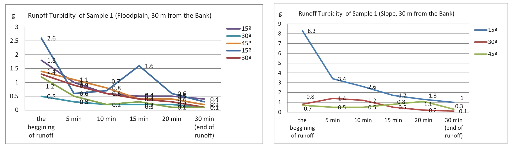
Fig.3 Graph of forest soil loss depending on the runoff time. Sample 1.
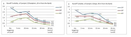
Fig.4 Graph of forest soil loss depending on the runoff time. Sample 2.
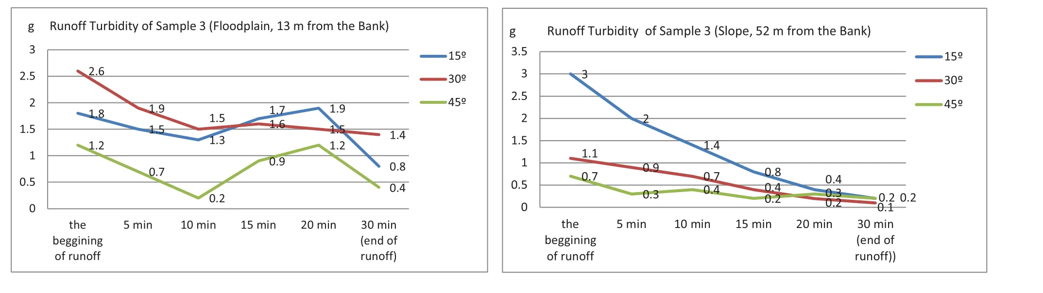
Fig.5 Graph of forest soil loss depending on the runoff time. Sample 3.
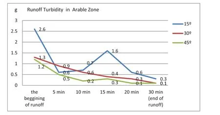
Fig.6 The influence of the rain intensity mass of washed off soil at different runoff slopes(arable land).

The studies have shown (Figs 3-6) that the turbidity of the runoff on the arable land with a continuous unchanged rainfall starts at the intensity of 0.2 mm/min,literally in the tenth second of the beginning of rain.The insignificant increases in the fall of precipitation of the intensity up to 0.3 mm/min accelerated the beginning of runoff, over this predetermined equal period, the turbidity of the soil increased by several times, as studies show by six times(Tomlinson et al.,2012).
Consequently, the time of the appearance of turbidity of runoff and washout of the studied soil under tree species depends on the strength and density of their roots.
The graph demonstrates that the intensity of absorption of moisture into the soil under the Birch tree begins later than that of Linden and Alder,this means that the root system of the Birch tree in this forestry is denser than in other species since the retaining root strength contributes to the retaining of soil on the slope of 45 degrees.
And so,dense and bound plant layer holds the soil with a root system and protects the soil from raindrops and swimming,creates high roughness of the surface,which reduces the rate of soils runoff.
6 Conclusion
On the slope at a distance of 13-52 m from the bank in Birskoye forestry in the 57th quarter,the formation of the surface runoff under conditions of heavy rainfall begins after 10 hours,with rainfall after 0.22 hours(13 min)of tracking,and with steady shower–0.1 hours(5 min). With the intensity of precipitation on the arable zone,in areas with slight slopes,the formation of runoff occurs 7 hours earlier than in the forest.
Dynamically the turbidity of the runoff can be mathematically divided into three stages, and graphically it can be similar to a parabola. The first stage is a slow or sharp increase in runoff turbidity, which is associated with the effect of reaching particles along the slope. In the second stage,there is a maximum of turbidity,and in the third stage there is a gradual decrease in turbidity.
The underlying soils have more excellent erosion stability and soil erosion, and the soil runoff is not so critical on the slopes in the water protection zone. The intensity of moisture absorption into the soil under the birch begins later than that of Linden and Alder;this means that the retaining strength of roots of the Birch tree is denser than that of other trees species since the retaining strength of roots contributes to keeping soil on the slope of 45 degrees. It was revealed that the well-developed plant cover strengthens the soil with the root system and protects the soil from raindrops and swimming;it creates high surface roughness,which reduces the rate of slope runoff.
杂志排行

Journal of Environmental Accounting and Management的其它文章
- The Development of Countering Monopolization in the Electric Energy Industry
- The Influence of Alternative Fuels on the Development of Large-Scale Production
- A Retrospective Comparison on Europe and China Ecological Wisdom of Pre-Industrial Urban Communities of under the Lens of Sustainability Pillars
- Green Lifestyle among Indonesian Millennials: A Comparative Study between Asia and Europe
- Legislative Regulation of Criminal Liability for Environmental Crimes
- Regional Diversif cation of Rural Territories with Limited Spatial Location of Green Tourism Objects