财税史里话运河
2020-12-08陈阳
陈阳
运河从来不是哪个帝王一时心血来潮下江南的产物,它是王朝统治的经济命脉,国家财政运转赖以为系的动脉,也是国家财政支出的对象,是古代中国财政运转最具体的媒介之一。
半个中国之财赋悉由此路而进
中国地势西高东低,大型的天然河流(例如海河、黄河、淮河、长江、钱塘江等)一路向东,流入大海。为了解决南北之间的交通运输问题,古代中国人只能通过开凿南北走向的人工水系来连通天然的大江大河,因而成就了中国贡献给世界的历史遗产、南北走向的大型人工水系——京杭大运河。
京杭大运河开凿于春秋,扩修于隋,繁荣于唐宋,取直于元,疏通于明清,是中华文明的重要标识。大运河早期多因战争需要而开凿,隋唐以后直至明清的主要功用是漕运,是持续至今仍在使用的活态文化遗产。
京杭大運河流经北京、天津、河北、山东、河南、安徽、江苏、浙江六省二市,其演变与发展涉及制度、经济、社会、文化等诸多方面。作为由国家开凿、政府管理的巨大水利工程体系,大运河承载了以农立国的古代中国特有的漕运文化传统。
浙江境内的古运道
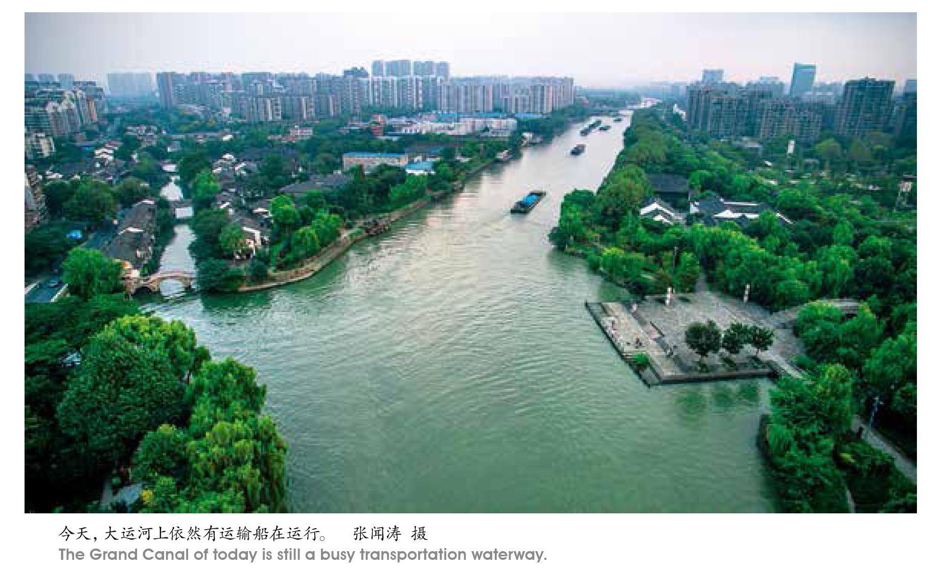
京杭大运河浙江段作为中国大运河的南端,包括形成时间较早、连续运用时间最长、自然条件最好的河段——江南运河和大运河内河航运通道与外海连接的纽带——浙东运河两段河道,至今仍发挥着航运、水利、行洪等功能。它们的历史,是一部越地从区域性政权融入统一帝国、越地文化和中原文化交流融合的历史,也是一部国家为了汲取税赋推动运河贯通、带动城市发展的历史。
我国河流多为东西走向,战国以前,水路运输仍限于自然河道范围内,南北交通极为不便。春秋末年,各国开始兴建运河工程沟通天然水道,但这些工程普遍规模较小。南方吴、越两国分别崛起后,随着经济、军事的发展开始向外扩张,原来的天然河流已经不能满足航运需求,由此,两国先后利用东南地区水网发达的优势,开始改造、建设一些运河,用于航运、灌溉之用。
吴国开凿了一条连通吴地到长江的南北向运河,与江北的邗沟串联,形成吴地向北的运河水系;向南修建百尺渎,连通吴越两地,从由拳(嘉兴)出发,经过盐官到达钱塘江,渡江以后进入越地,最终连通越国都城会稽。这是文献记载可见的太湖流域与浙江(钱塘江)最早的联系通道。这条水运通道存在数百年,是吴越两地主要的联系渠道,一直到秦始皇征服楚国后,在长江南翼开辟陵水道,渡江不再经由盐官,而是多经由更加安全的钱塘县(杭州)。陵水道逐渐取代百尺渎,成为沟通太湖流域与浙江(钱塘江)的主要联系通道。这条渠道的开筑,使偏远的越国地区、会稽郡范围的地域有效地进入了中央政府控制的范围内,也形成了今日所说江南运河浙江段的早期形态。
越王勾践时期贯通的山阴故水道,西起绍兴城东郭门,东至今上虞县东关镇练塘村,全长约20.7公里,与《越绝书》的记载大致符合。东晋时会稽内史贺循连接、疏浚了山阴故水道和其他旧有河道的一部分,形成西陵运河。后又不断改造,这条由钱塘江而达会稽的运河,与上虞以东运河以及姚江、甬江的自然水道一起最后汇入东海,形成了通江达海的浙东运河。
这些人工开凿的运河,在不同地域的具体河段可能有特定的名字,不同时期的拓展延伸或改建又会形成新的名字,今天的人需要一些时间才能理清它们的关系。
钱塘江两岸的运河,和其他区域的人工运河一起,到战国末期已经形成了一张四通八达的水路交通网,也拉开先秦各国水利建设的序幕,不仅沟通几大水系,畅通了区域交通网络,改善了沿岸农业条件,促进了工商业的兴盛,加强了各地区思想文化的交流,也加速了各民族间的沟通、交往与融合,为进入统一大帝国的时代奠定了物质基础。
一条关系国家安定的通道
随着秦汉帝国的建立,人工运河的主要功能从军事、政治转向漕运。
漕运是封建王朝通过水路(或附以陆路)向都城或其他指定地点大规模输送粮草的一种经济活动。这种国家财政物资的拨付转运,一般有三大类别:供都城消费的“京师之运”,供军队之需的“兵营之运”,供赈灾济荒的“赈济之运”。其中以保证皇室、百官及中央行政运转所需的“京师之运”最为根本。因漕运而生的一整套制度、设施以及活动于其间的人,随着漕粮主要产地的转移和经济重心区的变化,共同构成古代封建王朝的动力供应系统。
漕粮从哪里来,决定了漕运网络的形状和布局。中国古代漕粮来源地的变化,使漕运体系的发展呈现出明显的阶段性特点。
秦汉时期,漕粮供应地主要是黄河中下游地区,关东、山东粟运往关中政治中心所在,这个阶段漕运以长安为中心,称为“关东之漕”。东汉至隋唐,随着江南的开发,东南地区日渐成为朝廷的主要赋税来源,漕粮供应地由关东逐渐转向江淮,“关东之漕”转为“江淮之漕”。
把漕粮供应地更紧密地联系起来,是隋朝建国以后修建贯通南北的大运河的巨大推动力。随着大运河北通涿郡,南达钱塘江,它终于可以被称为京杭大运河了,其中,长江以南的这一段,北起镇江,南至杭州,又称江南运河,河面开阔,舟楫往来最为便利,成为中原地区通往江南的主要运输通道。
唐代安史之乱以后,东南地区较少经受战乱破坏,长江下游经济得到迅速发展,全国的经济中心逐步从黄河流域转向长江流域,朝廷用度随之开始仰仗东南一带。史书上说,“赋出于天下,江南居十九”,“天下大计,仰于东南”,中央政府的粮食和衣料主要依赖东南漕运。两浙的漕粮由运河转输,漕运阻滞时,唐政府的官员和军队的衣食都成问题。
北宋以后,经济重心完全南移,江南地区成为经济与赋税重心。贯穿南北的京杭大运河,把江南经济重心与北方政治中心联接在一起,改变了延续千年之久的以中原地区为中心的漕运体系,原来的“江淮之漕”转变为“江南之漕”。
北宋都城汴京(又称大梁、今开封),南宋都城临安(今杭州),分处运河南北的水陆交通中心和漕运枢纽位置,以汴京或临安为中心建立起来的漕运体系,形成一个严密而有效的供给系统,源源不断地将各地粮食物资输送到都城所在地,也将中国古代漕运发展推向巅峰时期。
运河南端的杭州城
从东西向的“关东之漕”到南北向的“江南之漕”,财政经济大动脉的根本转向就发生在两宋。这种转向甚至带动了政治轴心的改变,我们对首都的称呼,从东都、西都变成了南京、北京。
位于京杭大运河最南端的杭州,也在这个过程中改变了命运。春秋至隋以前的两浙一带,钱塘江以北(即浙西)以吴郡(即苏州)为重镇,钱塘江以南(即浙东)以会稽为中心。杭州所在的钱唐,不过区区一县,地位大不如吴郡、会稽。
隋文帝时期杨素主持营建杭州城,是杭州历史上第一次建造州城。紧接着江南运河疏浚贯通,杭州成为贯穿中国南北大运河的南端终点,由此开始了从原来的山中小县,逐步成为水居江河之会、陆介两浙之间的要地,走向了大都市的发展历程。
南宋建都临安(即杭州),运河是沟通中原的主要渠道,从镇江至杭州这一段的运河有专门名字——浙西运河。
到了元朝,大运河疏浚取直,不再绕道洛阳,以最短的距离,纵贯当时最富庶的东部沿海区域,实现了国家政治中心和经济中心的大融合。
南宋以后,杭州虽然丧失了政治中心的优势,但唐宋以来的发展打下了良好的基础。到了明朝,杭州商业繁荣,街道上商店林立,货物充盈,一派繁荣景象。
从宋代到明清,由杭州府之武林驿,向北经过湖州府德清县,嘉兴府崇德县、桐乡县,最后到达苏州府吴江县,始终是经由杭州城北上的主要通道。
北宋熙宁年间日本僧人成寻,坐船从杭州出发北上汴梁,其《参天台五台山记》记录了行船路线及所用时日,走的就是这条线路。
南宋时陆游《入蜀记》记录了他从绍兴出发到蜀地的经由线路,在钱塘江以南,经过柯桥、钱清、萧山、西兴,走的正是浙东运河。渡江以后,走浙西运河,线路与成寻所记载的相同。
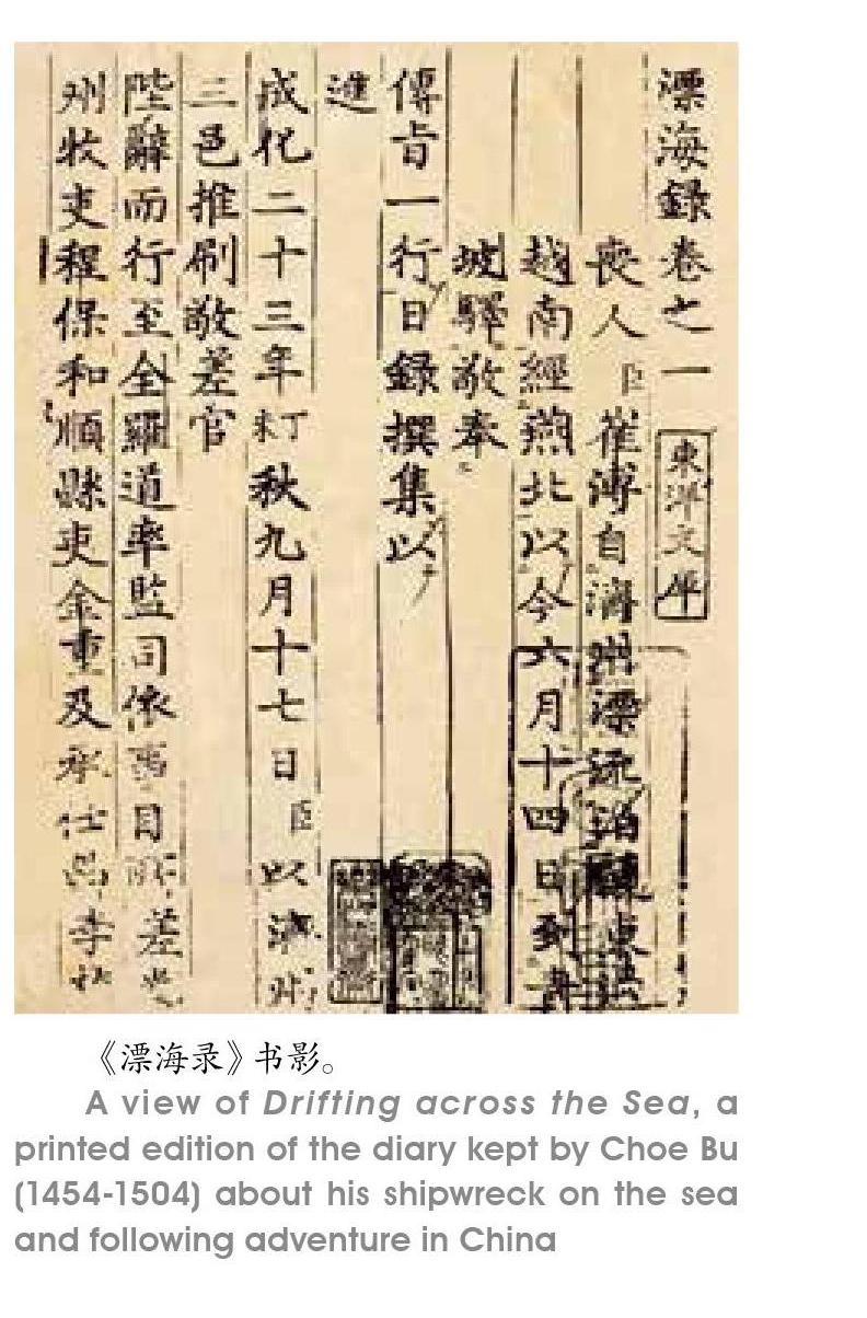
明代弘治年间,朝鲜文臣崔溥從济州出发前往罗州,途中不幸遭遇海难,在海上漂流13天后,意外地漂到了中国。在浙江台州府临海牛头外洋(今属浙江三门县)登陆后,经宁波、绍兴至杭州,继而沿运河路北上,抵达北京,再经陆路返回朝鲜,历时135天,成为明代第一个行经运河全程的朝鲜人。崔溥回国后,将这段神奇的经历撰写成书,名为《漂海录》。
到了清代,对这条线路的记录更是比比皆是。
杭州城北的大关和运河税收
历代商民的经济交往、文化交流沿着大运河展开,但它首先是一条输送国家财政税收物资的“高速路”,上面航行的最重要的是漕船。装载着税收征缴的白银、铜钱、粮食作物和纺织品,源源不断地通过运河进入国家仓库。
我们通常把北宋传世名画《清明上河图》作为风俗画解读,其实画家还着重描绘了漕运纲船,选取的题材和内容都是颇有深意的。
《清明上河图》留下了宋代漕船的清晰形象,画中画了大大小小共29只船,分为漕船、客船和游船三类,画中圆短体阔的平底船,吃水浅,窗户少,载重量大,由官营作坊制造,在汴河上主要担负运输任务。透过画面,画家想告诉观画人,漕运是一件关乎京师供给的国之大事。
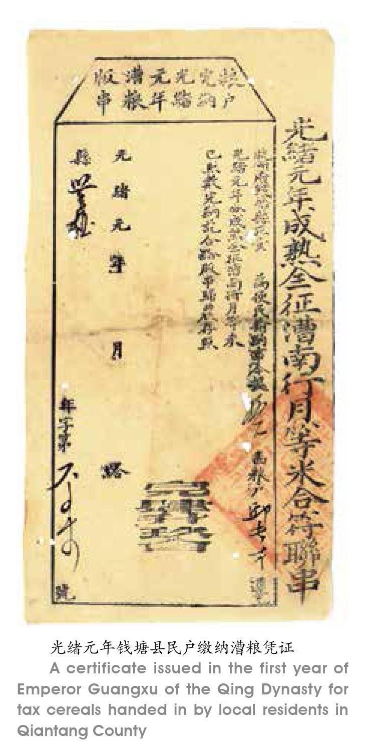
运河沿岸还有用于中转的粮仓。今天这些粮仓的遗址也成为运河文化遗产的重要组成部分。兴建于清代光绪年间的富义仓,建成后一直是杭州百姓最主要的粮食供应地,江南谷米的集散地,上缴朝廷的税粮也从这里启程北运。
国家也在大运河上面设置常关,征收国内关税。明清时期杭州城北所设北新关就是运河上重要的税关。
北新关在明代一直由南京户部差官管理。清初,由户部差官管理。康煕五十五年,停差户部官,由巡抚监收。雍正七年,税务交由织造府管理。清代的北新关在实际的管理运作中,由大关及其七务、六关、十门、八口址总共三十二所组成,由大关统率,各司其职,形成严密的商税控制网络。如果按照乾隆十八年的统计数据,北新关的税收收入近22万两,占清代在大运河、长江、淮河等重要水域交通要道所设税关总收入的百分之五强。
北新关是明清时代杭州的标志性景观,它在杭州城北前后存在400多年时间,至今在杭州人的观念和语言习惯中,仍保留着“大关”这一词汇。
大运河开凿贯通后在漕粮输运中发挥着重要作用,是国家财政运转赖以存在的重要基础设施,但是它的疏浚和维护也需要大量的财政支出。大运河支流繁多,与黄河、淮河、长江之间水道交汇错综复杂,这些水系的自然变迁都可能对大运河造成巨大影响,因此,对大运河的疏浚治理是历代政府的常态之举。例如,防止黄河泥沙流入运河,就一直是保证运河通航必须解决的老大难问题,为此修建了一系列的堤、坝、闸、墩、引河、河口等复杂的水工系统。在浙江境内,运河过钱塘江时也留下了若干重要的水利工程设施。浙东运河穿过多条自然河流,为维持水位的稳定并灌溉两岸农田,沿线设置了大量由堰坝和闸门组成的水利设施。
唐宋以来,上万只漕船,在不同季节时令运载着数百万石漕粮,在喧嚣静谧交替中往返于产粮区与京师之间。商品与贸易,方言与文化,信仰和文学,掺杂着社会风俗,与往来的漕船一起,随着运河水的流动,直到今天,依然在我们的生活里泛起点点涟漪。
Grand Canal: Imperial Lifeline
By Chen Yang
The Beijing-Hangzhou Grand Canal dates back to the Spring & Autumn period. It extended and expanded in the Sui Dynasty (581-618) and became full-flung in the centuries of the Tang (618-907) and the Song (960-1279). In the Yuan Dynasty (1279-1368), the major watercourse was straightened. In the Ming (1368-1644) and the Qing (1644-1911), it was dredged. It is a landmark canal of Chinese civilization.
The Grand Canal was first dug for war purposes. From the Sui Dynasty on, it functioned as the major route for cereals shipping from production regions in the south to the north and central China. Today, the Beijing-Hangzhou Grand Canal traverses Beijing, Tianjin, Hebei, Shandong, Henan, Anhui, Jiangsu and Zhejiang. The canal has evolved and developed, shaping aspects of Chinas governance, economy, society and culture. As a giant water-control engineering system constructed and operated by the central government, the Grand Canal used to feature the shipping tradition of an agricultural nation.
Ancient canals in Zhejiang
Hangzhou in Zhejiang was at the southernmost tip of the Grand Canal before the system crossed the Qiantang River and extended eastward to Shaoxing and Ningbo. The Jiangnan section of the Grand Canal and the Eastern Zhejiang Canal are very much alive today. They play a key role in cargo shipping, water control and flood discharging. The history of these two canals tells stories concerning how a regional power merged into the empire and how the Yue culture united with the culture of the central kingdom. The history of the two canals also tells how, in order to levy taxes effectively and sustain national revenue, a nation maintained the operation of the canal and boosted the growth and prosperity of canal cities and towns.
River transport in ancient China went from east to west and vice versa largely because rivers in China mainly go from west to east due to the geographic features. It was much difficult to ship cargo through rivers from north to south and vice versa. In Jiangnan or the region in the south of the Yangtze River Delta, there was a dense network of rivers. Boats and ships were the major way to travel around and move things around. In Spring & Autumn centuries, the Wu and the Yue states rose in the region. Canals were constructed for economic and agricultural purposes. The Wu state in the north of Jiangnan built a canal to connect with the Yangtze River. It then built a canal to connect with the Yue state to the south. According to history, the canals and rivers linked the Wu and the Yue, with Taihu Lake at the northern tip of the canal system and Kuaiji, the capital of the Yue, at the southern end of the regional canal system. The canal system shared by the two states prospered for hundreds of years. After the First Emperor of the Qin (221-207BC)unified the whole nation, he had another canal built to make the existing canal system more effective. This correction of the system brought the remote Yue in the south of the Qiantang River under the effective control of the empire.
The canal system to the south of the Qiantang River connects with a number of regional rivers and reaches East China Sea. With the canals and rivers to the north of the Qiantang River, they formed a system. The system boosted social and economic growth of the region and gave support to the empire.
After the Qin Dynasty, the function of the canals shifted from military to cereal transport from the south to the north. In the past, the canal system in China shipped food northward for three important functions: the canal system maintained the food supply and daily consumption of the capital city, shipped food supplies to military, and transported food to regions in emergencies such as natural disasters. The most important task the canal system did was to serve as a lifeline, specifically, for the imperial house, all the officials, and the central government situated in the capital city. To satisfy this requirement, the central government designed and put into place a whole system of administration, policies and rules for the operation of the Grand Canal.
During the Qin and the Western Han (206BC-25AD), the cereal supply came largely from the middle and lower reaches of the Yellow River. During these centuries, Changan in present-day Shaanxi Province in northwestern China was the center and destination of the shipping system and food moved from west to east in the northern part of the country. From the Eastern Han (25-220) down to the Sui and the Tang dynasties, the Southeast China became a major food supplier. The Sui Dynasty extended the canal all the way to the Qiantang River. The canal from south to north of this period can be correctly called the Capital-Hangzhou Canal.
After the An Lushan-Shi Siming Rebellion (755-763) of the Tang Dynasty, the economic center further shifted to the southeast, namely, the region of the lower reaches of the Yangtze River Delta. The tax revenue from the region accounted for the 90% of the national total. The food and fabric supplies from this region kept the central government in operation. In the Northern Song Dynasty, the political center in the north and the economic center in the south were connected and sustained by the canal system.
Hangzhou at the Southern End of the Grand Canal
Hangzhou evolved slowly at the southern end of the Grand Canal. In the Sui Dynasty, the city of Hangzhou was built to guard the southern end of the Grand Canal. The small county nestled at the foot of mountains west of the West Lake moved its capital to the present-day Hangzhou. The new county capital was on the right track onto becoming a metropolis.
The turning point in the history of Hangzhou occurred in the Northern Song and the Southern Song. Hangzhou was the central city of the supply side on the south connecting with the political center in the north during the Northern Song. During the Southern Song, the capital city was the political, cultural and economic center of the dynasty.
In the Yuan Dynasty, the canal didnt go to Luoyang any more. It went straightforward northward to the capital of Yuan Dynasty in the north. The capital was the predecessor of present-day Beijing. The canal became the shortest route that went through the richest regions of the country, fusing the political and economic centers. After the Southern Song Dynasty fell apart, Hangzhou ceased to be the political center of the nation, but it continued to prosper. It prospered more in the Ming and the Qing economically and culturally, as testified by a large amount of travel literature on boat trips from Hangzhou to the north including some well-known accounts by Japanese monks, poets and a Korean government official.
