Evaluation of groundwater geochemical characteristics and quality in the central and Northern Shaanxi Province, China
2020-11-10HuiYanJunXiaoTingLiuYujieLiu
Hui Yan · Jun Xiao · Ting Liu · Yujie Liu
Abstract Groundwater is of vital importance to many aspects of ecosystem services,especially in the central and northern Shaanxi Provence, China,— an area covered by loess deposits and short of water resources.We studied the solute geochemistry and water quality of groundwater in this area to improve the understanding of hydrogeochemical processes in loess deposits area. The results showed that the average pH of groundwaters was 8.03 ± 0.36 (1 SD) with large ranges (324 - 83,379 mg/L) of the total dissolved solids (TDS). The cations and anions followed the order of Na+ > Ca2+ >Mg2+ >K+ > SiO2 and Most groundwater samples show the water type and a small number of samples the Na+-Cl- type. Irrigation water quality assessments showed that 40% of the groundwater has good water quality, 42% moderate water quality, and 18% (the upper reaches of Wuding River and Wei River) poor water quality with very high salinity.About 40% of groundwater samples were not suitable for drinking due to the high TDS, fluoride, sulfide, and chloride. Gibbs plot and stoichiometry analysis showed that carbonate weathering is the main source of groundwater chemistry in central Shaanxi Province while evaporite dissolution dominates in northern Shaanxi Provence. The loess weathering significantly influences the dissolved solutes of groundwater in the Loess Plateau. The ion-exchange between Mg2+ and Ca2+ in groundwater and Na+in clay minerals and the deposition of carbonate minerals increased Na+but decreased the Ca2+in groundwater.Our research results improve our understanding of hydrogeochemical processes that affect the solutes chemistry of groundwater in the loess area and provide essential data to the global groundwater database.
Keywords Geochemical characteristics · Hydrochemical process · Groundwater quality · Central and northern Shaanxi
1 Introduction
Groundwater is a vital natural resource,which plays a vital role in the ecosystem services in semi-arid and arid regions(Currell et al. 2012; Han et al. 2016; El Alfy et al. 2017;Wang et al. 2019). In the case of water deficiency and pollution, groundwater becomes a more precious water resource (Cao et al. 2019; Li et al. 2019a, b; Liu et al.2019).The geochemical characteristics of groundwater are regulated by atmospheric input, rock weathering, anthropogenic activities,and biogeochemical processes(Pincetti-Zúniga et al. 2020). The source of the dissolved solutes in groundwater can be revealed by hydrochemistry analysis.High concentrations of Ca2+, Mg2+, andwere mainly from carbonates weathering, high Na+and K+are supplied by evaporites dissolution or/and silicate weathering, highand Cl-were usually from evaporite dissolution, high SiO2was from silicate weathering, and highwas mainly form anthropogenic input (Xiao et al. 2015, 2016). Some geochemical processes can influence the contents of major ions. Evaporation can increase concentrations of Na+and Cl-and may lead to carbonate precipitation, which can decrease the concentrations of Ca2+andMeanwhile,human pollution can lead to a high concentration ofTherefore,better knowledge of geochemical processes determining the characteristics of the solute of groundwater can provide useful information for groundwater quality evaluation and scientific development and utilization of groundwater(Jamshidzadeh and Mirbagheri 2011; Su et al. 2019; Hossain and Patra 2020).
Covered by Quaternary loess deposits, the central and northern Shaanxi Province, one of the most important cradles of human civilization, is now facing many challenges such as water-deficient and water quality deterioration (Li et al. 2019a, b). Groundwater is the precious water resource for human, agriculture, and industrial consumption, which became increasingly important for sustainable development in the central and northern Shaanxi Province. The loess-paleosol is well-known for its role in the record of paleoclimate parameters(Liu 1985).How the loess impacts the groundwater chemistry, however, was less studied.Previous studies of surface water in the Loess Plateau showed that river draining this region was characterized by evaporite dissolution and carbonate weathering, potentially impacted by loess covered groundwater(Fan et al. 2014; Xiao et al. 2016; Li et al. 2019a, b).However, there was less information about geochemistry and groundwater quality of regional groundwater in central and northern Shaanxi Province, on which an exploratory study is necessary.
Our study aimed to reveal the geochemical characters and water quality of groundwater in the central and northern Shaanxi Province.Knowledge of these can lead to improved understanding of hydrochemical systems in loess environments, promote effective management of groundwater resources, and provide essential groundwater data to a global database.
2 Materials and methods
2.1 Site description and catchment geology
Lying in the middle Reaches of the Yellow River,Shaanxi Province ranges from 31.70°to 39.58°N and from 105.48°to 111.25° E, and borders on several provinces, such as Shanxi, Inner Mongolia, Ningxia, Gansu, Sichuan, Hubei,and Chongqing. Therefore, it serves a link of communication between the southwest, northwest, and east China(Liu et al. 2013). With an area of 2.058 × 10⁵km2,Shaanxi Province takes up 2.14% of the country’s total territory. The Shaanxi Province is divided into Northern Shaanxi Plateau, Central Shaanxi Plain, and Southern Shaanxi Mountainous Region (Fig. 1). Topographically,Shaanxi Province is long from north to south and narrow from east to west with a higher altitude in both south and north but lower in the middle. With an abundance of rainfall and a stretch of fertile land, central Shaanxi Plain has become a famous agriculture basis while the northern Shaanxi Plateau is an energy base with a large quantity of natural gas, petroleum and coal deposits.
The climates of Shaanxi Province are varied with a cold arid or cold semi-arid climate in northern parts and semiarid in the central part. The annual averaged temperature of Northern Shaanxi Plateau and Central Shaanxi Plain varies from 7 to 12 °C, and from 12 to 14 °C,respectively.The annual precipitation ranges from 200 mm in the northwest to 750 mm and decreases from southern to northern, and mainly occurs from July and September(Xiao et al. 2016; Wang et al. 2018).
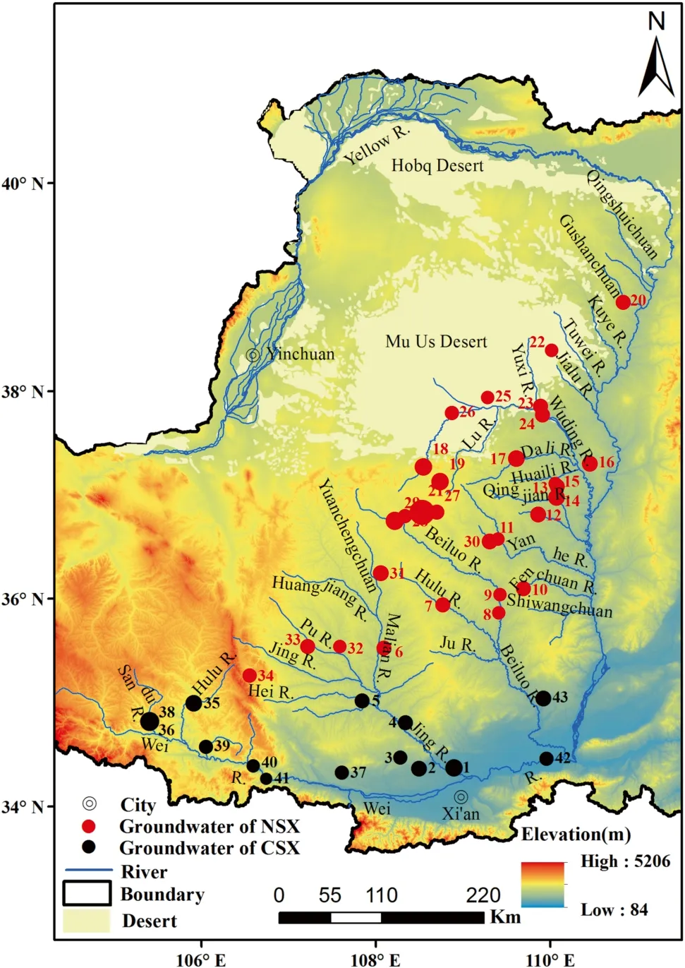
Fig. 1 Sampling locations of groundwater in the central and northern Shaanxi Province. The circle size indicates the TDS values of groundwater. The bigger the circle, the higher the TDS value
2.2 Sampling and methods
43 well water samples were collected systematically in the Shaanxi Province in the dry season in 2013. According to the lithology of the catchment and groundwaters’ location,samples were divided into Central Shaanxi and North Shaanxi and were marked as CSX and NSX, respectively.Groundwaters were filtered through 0.22-μm infilters during sampling. For cation analysis, 60 mL of the filtrate was acidified to pH <2 with ultrapure HNO3and stored in HDPL Nalgene bottles. For anion analysis, 30 mL of the filtrate was stored in HDPL Nalgene bottles without acidification. Some parameters, such as pH, T, TDS, and EC,were measured during sampling by using portable EC/pH meter(Orion 129).All groundwater samples were stored at 4 °C until analysis.More details of the sampling processes can be referend to Xiao et al. (2016).The cations of Ca2+,K+, Mg2+, Na+, and SiO2in groundwaters were determined by ICP-OES at the Institute of geochemistry with repeated analyses reproducibility <2%.Anions of F-,Cl-andwas determined by Ion Chromatograph (Dionex-600) with average replicated reproducibility from 0.5 to 1.0% (2σ).was titrated by 0.1 N HCl in-situ.Saturation index(SI)values of aragonite,calcite,dolomite,magnesite,gypsum,and halite were calculated by using the PHREEQC Version 3.
3 Results and discussion
3.1 Hydrogeochemistry
The statistics of TDS, EC, pH, and major ions of groundwater samples in the central and northern Shaanxi and the Chinese State Standard (CSS) for drinking water were listed in Table 1 and shown in Fig. 2.Samples were neutral to weakly alkaline with pH values ranging from 7.0 to 8.9.The TDS spanned significantly from 324 to 83,379 mg/L with the mean value of 3083 mg/L, much higher than surface waters in this area (Fan et al. 2014; Xiao et al.2016)and those in the Qinghai Lake catchment(Xiao et al.2012), Yinchuan Plain (Jing et al. 2016), and Fen River basin(Hua et al.2020),but lower than those in the Minqin basin (Zhu et al. 2007) and the Tarim Basin (Xiao et al.2015).About 60%of groundwaters was freshwater,and the other samples were brackish water. Generally, the TDS in the northern Shaanxi is higher than the central part(Fig. 2).Na+and Ca2+were the main cation component,occupying 90%of the total cations.SiO2and K+concentrations were very low compared with Na+, Ca2+,and Mg2+(Fig. 2).dominated in the anions followed by Cl-andThe concentrations of F-andwere very low.Generally, cations and ions sorted in order of Na+, Ca2+,Mg2+,SiO2,K+,andCl-,,F-,andrespectively (Fig. 2). The normalized inorganic charge balance (NICB % = 100*(TZ+-TZ-)/(TZ++TZ-) was used for checking data accuracy. NICB % varied from- 0.5%to 7.6%with an average value of 3.7%,indicating the data accuracy of our measurements.
3.2 Groundwater type
Strong-positive relationship with significantPlevel 0.01 were found between Mg2+and Na+(R2= 0.95), between Ca2+and Na+(R2= 0.88), between Mg2+and Ca2+(R2= 0.81),betweenand Cl-(R2= 0.97),between Na+and(R2= 0.97), and between Na+and Cl-(R2= 0.97), indicating their similar sources. Solutes in groundwater were mainly from rock weathering (Gibbs,1970). Different weathering processes can yield different combinations of dissolved solutes. Carbonates weathering can generate an amount of Ca2+, Mg2+, andevaporites dissolution can generate Na+, Cl-, andand silicates weathering can produce Na+and(Jansen et al. 2010). Therefore, the analysis of solutes in groundwater can deduce their sources and water types.The ternary diagrams showed that groundwater types in the central and northern Shaanxi belong to different groups.Na+, Ca2+, andwere higher while Mg2+and Cl-were lower in most samples (Fig. 3). The major ions followed order of Na+>Ca2+>Mg2+>SiO2> K+andThese groundwaters werewater type, which presumably form carbonates weathering. This was in accordance with the high carbonates content in loess (Liu, 1985). The analysis of river water in Loess Plateau showed that about 30% of the dissolved solutes were from carbonate weathering. This indicated the influence of loess weathering on solutes geochemistry. Some samples had high Na+and Cl-, and the major ions ranked: Na+>Ca2+>Mg2+>K+andThese groundwaters were Cl-Na+water type, indicating the dominance of evaporites dissolution to these samples.Meanwhile,some data located in the center in Fig. 3, indicating their mixed groundwater type. Generally, most groundwater in CSX and NSX are bothwater type,and only few samples are Cl-Na+water type.The groundwater type is similar to the river waters in the Loess plateau (Xiao et al. 2016).
3.3 Groundwater quality assessment
Groundwater in the central and northern Shaanxi Province was mainly used for irrigation and especially for drinking.High Na+in groundwater together with high salinity can lead to deflocculation of soil and damage crop growth.The salinity and sodium adsorption ratio (SAR) were used for irrigation water quality assessment, which was calculated by the equation of SAR = Na/[(Ca + Mg)/2]0.5(Richards,1954). The clarification of groundwater quality based on SAR and salinity was according to Richards (1954) and Xiao et al. (2014). The total hardness (TH) was mainly caused by Ca2+and Mg2+and high TH groundwater can lead to gastroenteroathy. The TH and TDS were used for groundwater quality assessment for drinking purposes.The result showed that 40%of the groundwater belonged to the good water quality with relatively low hazards,42%of the samples belonged to the moderate water quality with high salinity hazards,and 18%were bad water quality with very high salinity hazards. The bad water quality samples are located in the upper reaches of the Wuding River and Wei River, and lower reaches of the Jing River (Figs. 1 and 4).For drinking purposes, Fig. 4b shows that that 60% of the groundwaters were belonged to hard-fresh water, among which 19% was moderate hard-fresh water, 26% was moderately hard-fresh water,and 15%was very hard-fresh water. 38% of the groundwaters were very hard-brackish water, and one sample belonged to very hard-saline groundwater (Fig. 4b). In addition, groundwater samples meet the pH standard for drinking except sample 11, 22,and 51 (Ministry of Health, 2006). Approximately 38 and 26% of the samples, mainly in the northern Shaanxi Province, exceeded fluoride and sulfate standard for drinking.of all samples were within its permissible standard of 323 mmol/L and approximately 17% of chloride in groundwaters exceeded its drinking standard. Therefore,the high concentrations of TDS, fluoride, sulfide, and chloride in groundwater in the central and northern Shaanxi Province should be brought to the forefront in the future.
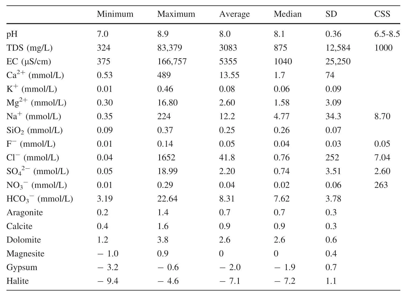
Table 1 Statistics of chemical composition and saturation index of groundwater in the central and northern Shaanxi and the Chinese State Standard(CSS) for drinking water

Fig. 2 Violin plots of TDS and major ions in the central (a) and northern Shaanxi Province (b). The violin plot shows the median (dark line),quartile range (dot line), and the curve on the sides provides the approximate frequency distribution. The units for concentration in Y-axis are mmol/L except for TDS is mg/L

Fig. 3 Groundwater types in the central and northern Shaanxi Province based on the ternary diagrams
3.4 Control factors and solute sources of groundwater
Gibbs diagram is a useful tool to decipher the controlling factor of dissolved solutes, such as rock weathering,evaporation influence, and precipitation dominance (Gibbs 1970). Groundwaters in the northwest area had high Na/(Na + Ca) ratios and TDS values and were located on the evaporation dominance zone, suggesting evaporation was the main controlling factors on the groundwater solutes(Fig. 5).This was in accordance with the high evaporation in the northwest of the study area (Li et al. 2019a, b). The evaporation may result in the oversaturation of some minerals.The saturation index(SI)values are calculated to evaluate the dissolution, equilibrium, and precipitation states of the mineral phases in the groundwaters. The calculated values of SI of aragonite, calcite, and dolomite of groundwaters varied from 0.2 to 1.4, 0.4 to 1.6, 1.2 to 3.8,and- 1.62 to 1.79,with average values of 0.7,0.9 and 2.6,respectively (Table 1). Thus, most of the groundwaters were oversaturated with respect to the above minerals,which may result in the secondary precipitation of these minerals in groundwaters and decrease their Ca2+, Mg2+,andAll the SI values for halite and gypsum were <0, indicating their under-saturated condition and the possible dissolution. This was verified by the positive relationship between Na+and Cl-, and between Ca2+andin groundwater.The increase of the Ca2+due to the gypsum dissolution could further lead to the super-saturation state of carbonates and its precipitation. Approximately, half of the SI values for magnesite were >0. In addition,most samples located in the rock dominance zone,indicating their rock weathering source (Fig. 5). Ions scatter diagram of stoichiometry analysis of some ions was showed in Fig. 6.During halite dissolution,the Na+will be equal to Cl-and the sample should be on the 1:1 stoichiometry line. In this study, only part of the samples was along the 1:1 Na/Cl line (Fig. 6a), and there was a strong positive relationship between Na+and Cl-in groundwater(R2= 0.97). This indicated the influence of halite dissolution on the dissolved solutes in Loess Plateau. Although the evaporites content was minor in Loess, the fast dissolution rate of it can generate abundant Na+and Cl-(Xiao et al. 2016). In addition, the evaporation can also increase the concentrations of Na+and Cl-(Fig. 5). Most samples had higher Na+than Cl-with an average Na/Cl molar ratio of 6.9 (Fig. 6a), indicating the other source of Na+except halite dissolution.Silicate weathering,anthropogenic input,and ion exchange may contribute to the redundant Na+(Mejri et al. 2014; Xiao et al. 2016). The (Na+-Cl-)plotted againstwas applied to reveal the possibility of cation exchange (Charfi et al.2013; Xiao et al. 2015). Figure 6b showed that (Na+-Cl-)was strongly negative withindicating the existence of exchange reactions between(Ca2++Mg2+)in groundwater and Na+on clays.The Na+absorbed on clays exchanged with Mg2+and Ca2+in groundwater, which can also contribute part Na+to groundwater. Carbonate weathering can generate a (Ca +Mg)/HCO3ratio of 1.0(Sami 1992).Figure 6c showed that most groundwater samples fell on this line,indicating their dominant carbonate sources.Some samples fell away from the 1:1 line, indicated there were other sources for these samples. The excess of (Ca2++Mg2+) overand(Na++K+) over Cl-was noted as (Ca2++Mg2+)*and(Na++K+)*, which were possibly from dissolution of sulfate. Figure 6d showed that the NSX samples were along the 1:1 line, indicating the contribution of sulfate dissolution to groundwater solutes. Thein the CSX samples exceed (Ca2++Mg2+)*+ (Na++K+)*, indicating their other source ofsuch as oxidation of sulfide minerals. Figure 6c showed that some groundwater samples haveover (Ca2++Mg2+), which was from eitherenrichment or (Ca2++Mg2+) depletion by cation exchange. Some NSX samples have higherconcentrations than(Fig. 6e), indicating stronger evaporite dissolution in these samples. The other samples have higherconcentrations than(Fig. 6e), indicating stronger carbonate weathering in these samples. Meanwhile (Ca + Mg)/(Na + K)ratio in groundwater was applied to evaluate the different weathering processes (Ahmad et al. 1998; Xiao et al. 2012). This value is high in carbonate areas while is low in evaporite areas.For example,this ratio of the Indus River and rivers in carbonates area was 6.0 and 10.0,while this ratio in rivers was 1.0 and 0.6 in the Taklimakan Desert and Ejina Basin(Ahmad et al.1998;Han and Liu,2004;Si et al. 2009; Xiao et al. 2012). Figure 6f showed that the TDS values were relatively low and (Ca + Mg)/(Na + K)ratios were high in CSX samples, indicating their stronger carbonate sources. Groundwater in NSX had relatively high TDS values and low (Ca + Mg)/(Na + K) ratio,indicating their stronger evaporite sources.
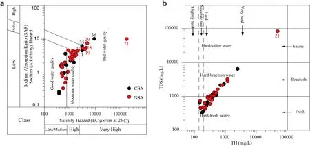
Fig. 4 Groundwater quality assessment for irrigation and drinking purposes in the central and northern Shaanxi Province.a and b share the same legend. The numbers in the figure are the sampling numbers
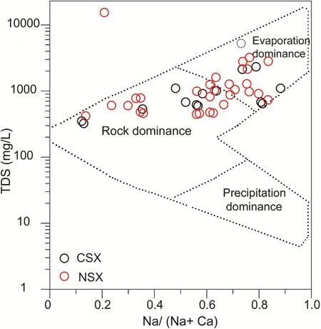
Fig. 5 Gibbs plots show the dominant factors of groundwaters in the central and northern Shaanxi Province. Solutes in groundwater were mainly from rock weathering together with evaporation influence
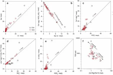
Fig. 6 Ions scatter diagram of groundwater showing the ions’ relationship in the central and northern Shaanxi Province
4 Conclusions
A detailed geochemical study of groundwater in the central and north Shaanxi Province in the Loess Plateau was carried out to determine groundwater characteristics,evaluate groundwater quality, and reveal solute sources. Most groundwaters were fresh groundwater with alkaline characteristics andwater type. The Gibbs plot and stoichiometric analysis of major ions indicated carbonate weathering dominate the dissolved solutes in CSX and evaporite dissolution dominated in NSX. Evaporation and cation exchange are also the controlling factors. In addition, carbonate precipitation may exist due to their oversaturated state. High salinity hazards and high total hardness in groundwater was the main problem for irrigation and drinking purpose. More attention should be paid to the highin groundwater in the study area. This study highlights the influence of loess weathering on the dissolved solutes in Loess Plateau and can provide the basis for groundwater quality protection and management in the central and northern of Shaanxi Province.
AcknowledgementsThis work was financially supported by the Shaanxi Science Fund for Distinguished Young Scholars (2020JC-030), the CAS ‘Light of West China’ Program (XAB2018A02), the National Natural Science Foundation of China (41673128), and the Strategic Priority Research Program of Chinese Academy of Sciences(XDB40020200). The authors are grateful to anonymous reviewers and editors for their constructive comments and suggestions, which improved the quality of the manuscript.
Compliance with ethical standards
Conflict of interestThe authors declare that they have no known competing financial interests or personal relationships that could have appeared to influence the work reported in this paper.
杂志排行
Acta Geochimica的其它文章
- Late Ordovician mass extinction caused by global warming or cooling?
- In-situ LA-ICP-MS trace element and oxygen isotope signatures of magnetite from the Yamansu deposit, NW China, and their significance
- Geochemical constraints on the origin of Early Cretaceous alkaline intrusions and its tectonic implication, Sulu Orogenic Belt, Eastern North China Craton
- Hydrogeochemical characteristics of groundwater and quality assessment for the purposes of drinking and irrigation in Bougaa area, Northeastern Algeria
- Organic geochemical characteristics of Eocene crude oils from Zhanhua Depression, Bohai Bay Basin, China
- Geochronology and geochemistry of magmatic rocks in the Dongzi-Changhanboluo Pb-Zn ore district in Chifeng,Inner Mongolia, and their relationship with metallogenesis
