Downward shift of gas hydrate stability zone due to seafloor erosion in the eastern Dongsha Island, South China Sea*
2020-07-31JINJiapengWANGXiujuanHEMinLIJieYANChengzhiLIYuanpingZHOUJilinQIANJin
JIN Jiapeng , , , WANG Xiujuan , , , , , HE Min , LI Jie , YAN Chengzhi , LI Yuanping , ZHOU Jilin , , QIAN Jin , ,
1 Key Laboratory of Marine Geology and Environment & Center of Deep-Sea Research, Institute of Oceanology, Chinese Academy of Sciences, Qingdao 266071, China
2 Laboratory for Marine Mineral Resources, Pilot National Laboratory for Marine Science and Technology (Qingdao), Qingdao 266071, China
3 University of Chinese Academy of Sciences, Beijing 100049, China
4 Center for Ocean Mega-Science, Chinese Academy of Sciences, Qingdao 266071, China
5 Shenzhen Branch of China National Offshore Oil Corporation Ltd, Shenzhen 518054, China
Abstract New acquired and reprocessed three-dimensional (3D) seismic data were used to delineate the distribution and characterization of bottom simulating reflections (BSRs) in the Chaoshan Sag, in the eastern part of Dongsha Island, South China Sea. Three submarine canyons with different scales were interpreted from the 3D seismic data, displaying three stages of canyon development and are related with the variation of BSR. Abundant faults were identifi ed from the coherence and ant-tracing attributions extracted from 3D seismic data, which provide the evidence for fluid migration from deeper sediments to the gas hydrate stability zone (GHSZ). The uplift of Dongsha Island created a large number of faults and leads to the increased seafloor erosion. The erosion caused the cooling of the seafloor sediments and deepening of the base of the gas hydrate stability zone, which is attributed to the presence of paleo-BSR and BSR downward shift in the study area. Hence, methane gas may be released during the BSR resetting and gas hydrate dissociation related with seafloor erosion.
Keyword: bottom simulating reflections (BSRs); downward shift; seafloor erosion; gas hydrate dissociation
1 INTRODUCTION
Gas hydrate is an ice-like crystalline substance composed of water and gas (mainly methane) molecules within low temperature and high pressure which are widely distributed in the continental margins and subduction zones (e.g. Shipley et al., 1979; Sloan, 1998; Bang et al., 2005; Lu et al., 2007; Hornbach et al., 2008; Paganoni et al., 2018). Seismic data have been widely used to show the distribution and geological controls on gas hydrate occurrence using the anomalous amplitude reflections and geophysical properties. Bottom-simulating reflector (BSR) identifi ed from the seismic data was considered as an important indicator for the occurrence of gas hydrates in marine sediments (e.g. Shipley et al., 1979). However, the BSR is unsteady when the gas hydrate system is influenced by various complex geological processes such as sedimentation, erosion and uplift (Martin et al., 2004; Bangs et al., 2010; Davies et al., 2012). These processes will lead to the variation of the temperature and pressure near surface sediments (Bangs et al., 2010; Davies et al., 2012). The slight changes in temperature or pressure may trigger gas hydrate dissociation and methane seepage (e.g., Westbrook et al., 2009), which are the potential factors causing the catastrophic seafloor failure, ocean acidifi cation and global redistribution of carbon (e.g. Biastoch et al., 2011; Rupple and Kesler, 2017). The shifts and variable depths of BSR due to the canyon erosion have been widely found in the Nankai Trough (e.g. Martin et al., 2004; Kinoshita et al., 2011), the Lima Basin, Peru Margin (Pecher et al., 2001), and Mauritania (Davies and Clarke, 2010; Davies et al., 2012).
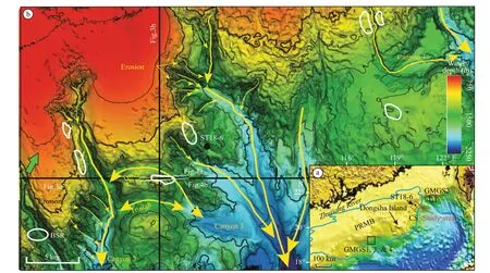
Fig.1 The study area in the Chaoshan Sag, near to the Dongsha Island, the Pearl River Mouth Basin (PRMB) (red rectangle in Fig.1a), the gas hydrate drilling expeditions (GMGS1, 2, 3, and 4) (black rectangles in Fig.1a), and the close-up of regional seafloor geomorphology (b)
The pore-fi lling gas hydrates have been widely identifi ed from the well log data and core samples in the Pearl River Mouth Basin (e.g. Wang et al., 2014, 2018; Yang et al., 2015, 2017a, b; Zhang et al., 2015) and the Qiongdongnan Basin (e.g. Wei et al., 2019; Ye et al., 2019) in the South China Sea (SCS) by Guangzhou Marine Geological Survey. Previous studies have demonstrated that the complex tectonic and sedimentary conditions in the Dongsha area are benefi cial for the formation and accumulation of gas hydrate (e.g. Liu et al., 2004; Yan and Liu, 2004). Gas hydrate drilling expeditions have been conducted at the east area of Jiulong methane seepage indicating gas hydrate with different morphologies above the BSR (e.g. Liu et al., 2006; Zhang et al., 2014; Sha et al., 2015; Wang et al., 2018). BSR has been confi rmed from seismic data and the anomalies of geophysical attributes in the Jieyang depression (Li et al., 2020). However, the gas hydrate system remains poorly known in the eastern Dongsha Island. In this study, we used new acquired three-dimensional (3D) seismic data to show the occurrence of BSR in the eastern Dongsha Island, SCS. We discussed the BSR variations controlled by the faults and seafloor erosion due to the uplift of Dongsha Island and the incision of submarine canyons.
2 GEOLOGICAL SETTING
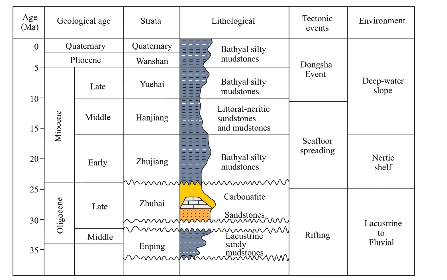
Fig.2 Stratigraphic scheme and main tectonic events in the Chaoshan sag
Gas hydrate drilling expeditions (GMGS1, GMGS3, and GMGS4) have been conducted in the Pearl River Mouth Basin, SCS, which located at the western area of Dongsha Island (Fig.1a). Abundant gas hydrates have been found and well delineated using the well log and seismic data (e.g. Yang et al., 2017a, b; Qian et al., 2018). The submarine canyons are composed of a series of complex architectural elements including a basal erosion surface, channellevee complexes and canyon confi ned sediments fans (e.g. Zhu et al., 2010; Zhou et al., 2015), which are related with the gas hydrate distribution. However, the gas hydrate in the Chaoshan Sag (the eastern Pearl River Mouth Basin) is poorly known due to the limitation of seismic and well log data (Fig.1a). The study area is located at the east part of Dongsha Island, which belongs to the Chaoshan sag. The Chaoshan sag has thin Cenozoic sediments (<1 000 m) and Mesozoic strata (>5 000 m) (Yan et al., 2006; Hao et al., 2009), which is a potential Mesozoic residual basin containing hydrocarbon gases (Liu, 2019; Wu et al., 2019).
The Chaoshan sag experienced multi-episodic rifting and subsidence influenced by the Dongsha movement during the period of the Late Miocene to Miocene (5.5 Ma), which is an important tectonic movement causing the broad doming, folding and strong erosion of the Ceno-Mesozoic strata, and even frequent hiatus of the Neogene-Quaternary deposition (Fig.2) (Zhao et al., 2012). The Zhuhai Formation is the main hydrocarbon source and reservoir-seal assemblages, providing the main exploration targets for hydrocarbon reservoir (Figs.2 & 3a). The basement uplift, erosion, and extensional faults of Chaoshan Sag were widely formed due to the Dongsha movement. A large number of faults observed in the Dongsha area provided excellent tectonic environment for the formation of gas hydrate (Yan and Liu, 2004; Yan et al., 2006). The faults were divided into two groups: northeast direction corresponding to the listric boundary-faults and northwest direction vertical with the slope downward direction (Liu, 2019). Many faults penetrate the basement with large displacements and some active faults can reach up to the seafloor. These faults mainly formed under extensional setting in the Late Cretaceous and Paleogene (Yan and Liu, 2004).
The previous study has reported that the canyon occurring in the Dongsha area is controlled by the bottom current of Kuroshio South China Sea Branch and seafloor topography of the Dongsha outer shelf, which eroded the uplifted Miocene drape formation (Luan et al., 2009, 2012; Zhuo et al., 2019). In the study area, both the strata on the flank and head (northwest) of canyons are characterized by headward erosion, indicating the potential current activity of erosional canyon (Fig.1b). Stratigraphic horizons such as horizon 5.5 Ma are clearly truncated at the seafloor on the landward (northwest) direction. Meanwhile, horizons 5.5 and 10.5 Ma are also truncated at steep walls of the troughs and canyons (Fig.3). The study area is far away from the sedimentary sources (over 150 km distance from terrigenous sediments, such as the Pearl River) (Fig.1a), and little if any sediment infi ll exists in the canyons despite locally steep slopes.
3 MATERIAL AND METHOD
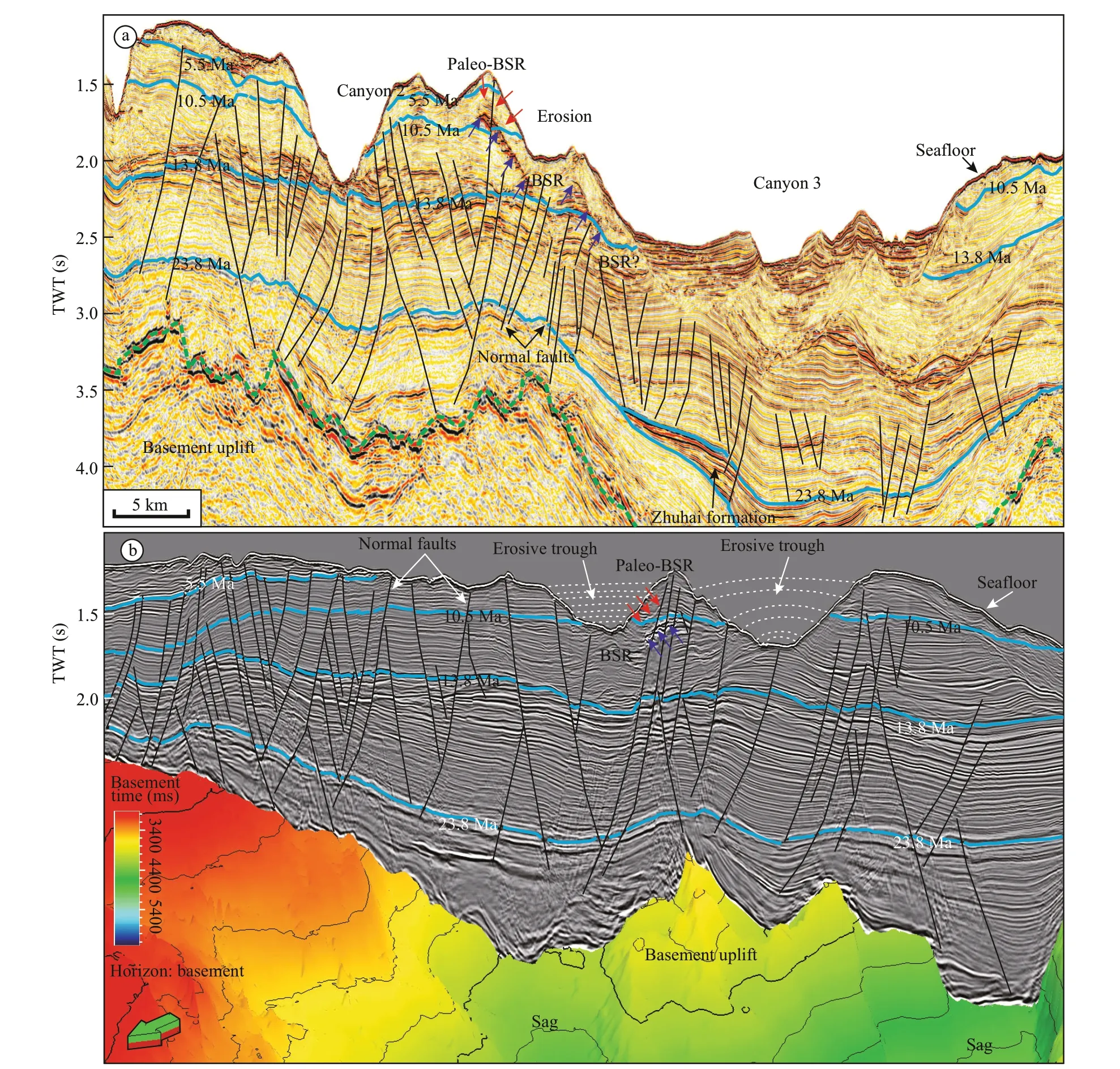
Fig.3 Interpreted seismic profi les through BSR showing the distinct erosion (see Fig.1b for locations)
The 3D seismic data with an area of 2 200 km2were acquired by China National Offshore Oil Corporation in 2014 for deep-water oil and gas exploration. The data were reprocessed in 2016 to study the occurrence of gas hydrate in this area. The 3D seismic data have a bin spacing of 12.5 m and 25 m in the in-line and cross-line directions, respectively. The main frequency of the seismic data is about 50 Hz and the sampling interval is 2 ms. The BSR was interpreted from the depth migration and time migration seismic profi les line by line in the whole area. The BSR shows the characteristics of a reversal polarity, paralleling to the seafloor and cross-cutting the sediments. The paleo-BSR with a positive amplitude found above the BSR is nearly parallel to the BSR by picking and tracing each line where the seismic amplitude is enhanced, which is used to analyze the influence of erosion process on the BSR shifts in the Chaoshan Sag, SCS.
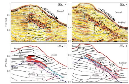
Fig.4 Various BSR types and characteristics identifi ed from seismic profi les in depth domain
The base of gas hydrate stability zone (BGHSZ) for methane was calculated using the hydrate prediction program from Colorado School of Mines (CSMHYD) (Sloan, 1998). The water depth was calculated from the two way travel time of 3D seismic data and was changed into depth in meter with an average P-wave velocity of water as 1 480 m/s. The pore-water salinity was assumed about 32. The seafloor temperature is about 4°C and the geothermal gradient is about 47°C/km obtained from Site ST18-6 (Fig.1), which are used to calculate the depth of BGHSZ for methane. The calculated regional BGHSZ depths of 3D seismic data were inverted to two-way travel time using the average P-wave velocity of 1 700 m/s (Li et al., 2020). The maximum amplitude attribute spanning a time window of 50 ms along the BGHSZ (30 ms above and 20 ms below) was extracted from the 3D seismic data to show the presence of gas hydrate. Two horizons (the seafloor and basement) were traced through 3D seismic data to delineate the paleo-uplift (Fig.3b) and erosion (Figs.1b & 3). Based on the theory of error analysis and similarity between adjacent seismic traces, the variance, and ant-tracing cube attributes extracted at horizons H1–H3 using Petrel E&P were used to describe the lateral amplitude discontinuities and to enhance the faults and fractures. The fault strikes were statistically analyzed from the identifi ed faults in three horizons below the BSR, which are plotted using rose diagram. In addition, negative polarity and enhanced reflections have been interpreted to indicate the occurrence of free gas beneath the BGHSZ.
4 RESULT
4.1 Characteristics and distribution of BSRs
BSRs were interpreted from 3D seismic data, which are parallel to the seafloor, reversal polarity and high amplitude (terminated below the BSR). The BSRs mapped on the 3D bathymetric map, are mainly distributed on the flanks of Canyons 1–3 over a total area of 220 km2(Fig.1b). Different types of BSRs including continuous BSR (CBSR), discontinuous BSR (DBSR) and paleo-BSR were identifi ed from the seismic profi les in the study area (Figs.1 & 4). CBSRs with continuously reflection, reversal polarity, high amplitude reflections comparing to the seafloor reflection were found at the flank of Canyon 1 and the crest of Canyon 3 (Figs.4 & 5). DBSRs with weak or high amplitude reflections, reversal polarity, crosscutting the dipping strata are located at the flanks of Canyon 2 and Canyon 3 and enhanced reflections occur at the dipping strata indicating the possible occurrence of free gas (Figs.4b & 5). A distinct reflection with the same polarity to seafloor, moderate or high amplitude, and crosscuts strata were found at the crest of Canyon 3 (Figs.4 & 5), which is the paleo-BSR and occurs at above the BSR. A series of high amplitude reflections were observed between the paleo-BSR and BSR, indicating the possible occurrence of gas hydrate-bearing sediments (Fig.4a & c).
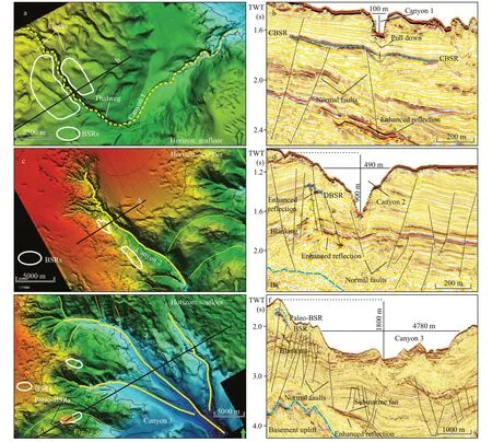
Fig.5 The BSRs at three different submarine canyons showing the variations due to erosion and faults
The depths of the BSR are variable. The deepest CBSR is about 235 m at the crest of Canyon 3 identifi ed from the depth domain seismic profi le (Fig.4a). The DBSRs are signifi cantly shallower along downward direction of the canyon flank. The shallowest DBSR at the foot of the flank is about 173 m corresponding to the increasing erosion toward canyon thalweg (Figs.4 & 5). The thickness between paleo-BSR and BSR is about 95 m indicating downward shift depth of gas hydrate stability zone. The calculated BGHSZ is mapped in the seismic profi le showing the simulating depth of BGHSZ increasing with water depth (Fig.4), which is distinctly different from the observed BSR depth.
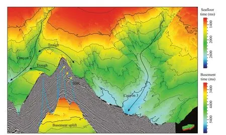
Fig.6 The 3D structural topography view of the interpreted seafloor and basement, showing the BSR that related to the erosive canyon and basement uplift
4.2 Incised canyon associated with BSR
Three representative submarine canyons (Canyons 1–3) with the signifi cant erosive characteristics were observed from seafloor topography map interpreted from 3D seismic data, showing NW-SE negative topography along the continental slope (Figs.1b & 3). The BSRs are distributed at the flanks of different scales canyons (Fig.1b).
Canyon 1 incising the nearly parallel sedimentary layers can represent an juvenile canyon with 190 m depth and 100 m wide, indicating a relative smallscale (Fig.5a & b). The CBSRs with high amplitude and negative polarity reflections are coincident with the horizontal layers in the two flanks of Canyon 1 (blue dash line) (Fig.5b). The BSR is weaker and downward shift below the canyon thalweg (thin green dash line) (Fig.5b). Enhanced reflections in deep sediments and pull-down below the canyon thalweg were identifi ed from the seismic profi le cross Canyon 1. Rare normal faults connect BSR with the deep sediments, suggesting the presence and migration of gas (Fig.5b).
Canyon 2 representing young canyon is about 900 m deep and 490 m wide, indicating a young canyon (Fig.5c & d). The BSR occurs at the western flank of Canyon 2, which is characterized by discontinuous, cross-cutting strata, and enhanced reflections terminated (Fig.5c & d). Amplitude blanking appears below the DBSRs, and the normal faults together with enhanced reflections in deep sediments were identifi ed, indicating the possible fluid migrating from deep sediments.
Canyon 3 is about 1 800 m deep and 4 780 m wide and can represent a large-scale mature canyon (Fig.5e & f). The complex BSRs occur on the western flank of Canyon 3. Abundant normal faults originate from the basement uplift and terminate at the BSR or reach up to the seafloor (Figs.4, 5f & 6). The faults together with the gas chimneys (blanking zone in the faults zone) provided potential fluid migration pathways from deeper sediments of submarine fans (possible Zhuhai formation) to the gas hydrate stability zone (GHSZ).
4.3 Faults and fluid leaking
A large number of faults have been observed from seismic profi les (Figs.3–7). Normal faults with various dip angles can reach up to the GHBS or seafloor, and penetrate the basement and gas-bearing structure. Corresponding to the expanding basement uplift, normal faults show the increasing numbers from Canyon 1 to Canyon 3 (Fig.5b, d & f). The faults in Canyon 3 are characterized by numerous and complex. We analyzed the faults in the western flank of Canyon 3 (about 1 km2) to show the detailed changes and their distributions with gas accumulation (Figs.7 & 8).
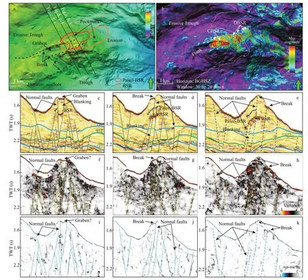
Fig.7 The seismic profi le and different attributes showing the relationship between faults and BSR
Many steeply-dipping normal faults were identifi ed below the BSR from the coherence and ant-tracing profi les, extending from the basement uplift to shallow sediments, which are consistent with those interpreted from the seismic profi les (Fig.7c– k). Variance slices along horizon H1–H3 (Fig.7c– e) were extracted to show the distributions of faults and rose diagram was used to show the geometrical characteristics of these faults. Ninety-nine faults identifi ed at the three horizon-coherence slices were analyzed by using the rose diagram to show the fault strikes. The faults below BSR have the same directions to those found at the analyzed zone, showing the NWW-SEE and SWW-NEE (Fig.8).
The maximum amplitude attribute shows continues high amplitude at the CBSRs and the stripped, high amplitude of DBSRs (Fig.7b). The potential occurrence of pockmarks with a negative seafloor topography was identifi ed above the BSR, indicating fluid escape feature in the seafloor (Fig.7a). The dipping strata with high amplitude cross cuts the BSR arriving to the seafloor, showing the relationship between fault system and the free gas zones below BSRs, hydrate zone, and methane seepage at the seafloor (Fig.4b & d). The break and graben of seafloor controlled by normal faults can be observed from seismic profi les and attribute profi les (Fig.7a & f–k). Therefore, sub-vertical faults cross cut the BSRs and paleo-BSR even reaching up to the seafloor (Fig.7a), which provide the pathways for fluids migrating to GHBS and seafloor from deep formations.
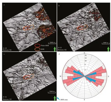
Fig.8 BSR distribution and faults at horizons H1–H3 in Fig.7c–e
5 DISCUSSION
5.1 BSR shifts triggered by submarine erosion
In most cases, the BSR indicates the BGHSZ, which is related to the pressure, temperature, salinity conditions, and gas composition (Shipley et al., 1979; Sloan, 1998). The double BSRs, in the Shenhu area (Qian et al., 2018), Donsha area (Li et al., 2015), and the NW Borneo (Paganoni et al., 2016, 2018) are related with Structure II gas hydrate formed by the thermogenic gas, which are obviously different from the BSR downward shift found in this study. In addition, several different factors triggered BSRs variations have been identifi ed from the seismic data in the ocean. In the southern Hydrate Ridge, offshore Oregon, a paleo-BSR occurred at the BSR and the upward shift of BSR was caused by the increase of bottom water temperature and a 120-m rise in sea level (Bangs et al., 2005). The variation BSRs caused by temperature change due to rapid sedimentation have been identifi ed in the Danube deep-sea fan, Black Sea (Zander et al., 2017). The factors such as the warming and cooling of bottom water temperature, sea-level fluctuation, regional tectonic activity, and seafloor erosion can cause the changes of pressure and temperature (P-T) conditions and modify the BGHSZ (e.g. Martin et al., 2004; Bangs et al., 2005; Davies et al., 2017; Sloan and Koh, 2017; Zander et al., 2017).
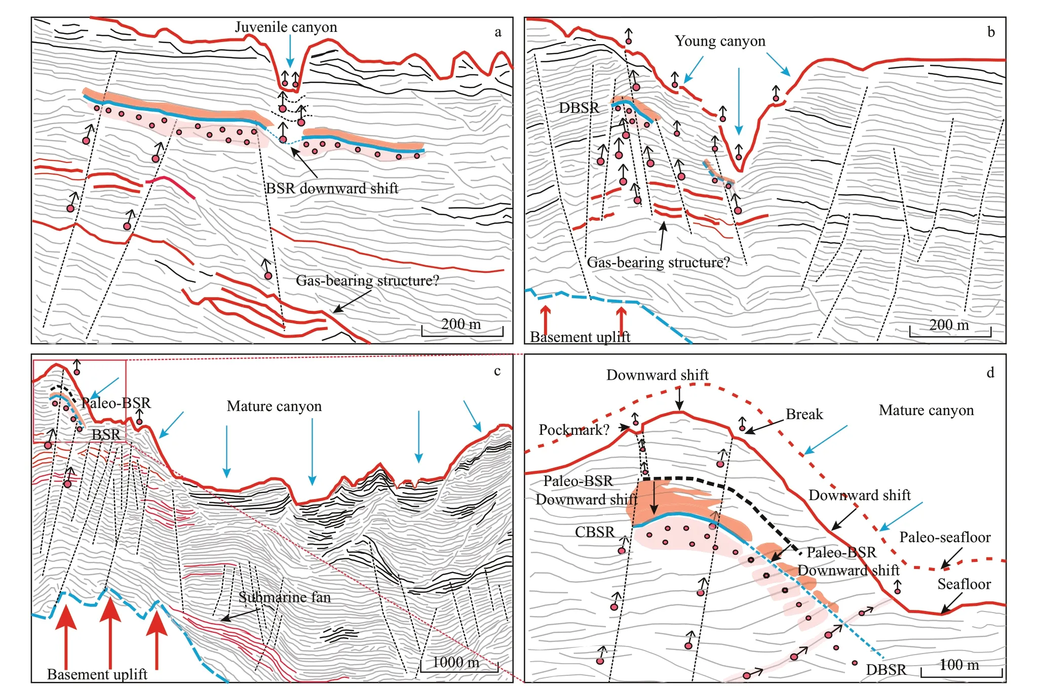
Fig.9 Schematic model shows the different canyon development stages and their effects on the shift of BSRs
In this study, BSR is slightly different from the BGHSZ (Fig.3c & d), and the different kinds of BSRs are caused by the dynamic geological progress, when the temperature and pressure conditions are quickly changed. Generally, BSR characterized by discontinuous, weak or absent reflections (i.e. DBSR) can be caused by eroded sediment waves and canyons (Hornbach et al., 2008), which can account for the occurrence of DBSRs in the erosive flanks of Canyon 2 & 3 (Fig.4d & f). The paleo-BSR observed within the gas hydrate stability zone (above the BSR) on the flank of Canyon 3 may be a paleo-BGHSZ before erosion (Fig.3a). For the study area, submarine erosion might be jointly caused by canyon activity, tectonic uplift, and marine hydraulic processes (Zhuo et al., 2019), which would result in the erosion and cooling of the shallow strata and subsequently the deepening of the BGHSZ, as found in the Blake Ridge (Hornbach et al., 2008) and the offshore of West Africa (Davies et al., 2012). The gas migrations from deeper sediments along normal faults and dipping strata provide the plenty of gas for the formation of the new BSR.
5.2 Development stages of BSRs
Combined three different scales submarine canyons corresponding with the characteristics of BSR, the BSR evolution process can be illustrated in the study area (Fig.9), which are associated with the sediment cooling and BSR resetting in a dynamic gas hydrate system. The study area, near to Dongsha Island, was influenced by the strongly regional crustal uplift (i.e. Dongsha uplift), which can be observed according to the observation of basement uplift in seismic profi le (Fig.3). The uplift will be followed by seafloor erosion. Three canyons characterized by headward erosion and flanks indicate that surface sediments erosion has been occurring up to the present, which is an important mechanism for BSR shift and hydrate recycle (Paull et al., 2002). However, the BSR characteristics and distribution are slightly different at the three canyon zones, which are related to the seafloor erosion and evolution stages identifi ed from seismic data.
The fi rst stage is the juvenile canyon indicating the onset of incision, where CBSR paralleling to the seafloor is formed by the presence of gas hydrate within the GHSZ (Fig.9a). A few methane gas was released due to the erosion near the canyon thalweg where the BSRs are weaker (Fig.9a). The basement uplift occurred and followed by the expansion of incision in the second stage (young canyon). A majority of hydrate-bearing sediments were eroded when the canyon is widened and deepen due to the erosion of sediment. BSR shows discontinuous reflection on the local flank and disappears at most locations of canyons (Fig.9b). A large number of gas hydrates and free gas were potentially released to marine in this stage (Davies et al., 2012), owing to the unloading pressure for overpressured free gas zones beneath the hydrate (Bang et al., 2010). Large-scale basement uplift and extensive incision occurred during the stage of mature canyon, and the temperature-pressure conditions would be changed due to thinning of GHSZ and cooling the sediments. The BGHSZ would shift downward to form the new equilibrium for gas hydrate and the new BSR would be formed due to the conversion of methane gas to hydrate (Hornbach et al., 2008). The paleo-BSR is residual BSR before seafloor erosion. It is clearly shown that the BSRs occur where sufficient gas migrates from deeper sediments along normal faults, dipping strata, and basement uplift (Fig.9c & d).
6 CONCLUSION
The different types of BSRs were identifi ed from the new acquired and reprocessed three-dimensional seismic data in the Chaoshan Sag of the eastern Dongsha Island, South China Sea (SCS). Due to the tectonic active caused by the Dongsha movement, three representative submarine canyons with erosion and incising features occurred in the study area, and the basement uplift caused many normal faults with NWW-SEE and SWW-NEE direction, which provide suitable tectonic settingt and fluid migration pathways from deeper sediments to shallow GHSZ. The continuous BSRs (CBSRs) and discontinuous BSRs (DBSRs) were found to present at the flanks of canyons, which are characterized by negative polarity comparing to seafloor, cross-cutting with strata and occur below the crest and slope of the canyons flank respectively. One reflection with positive polarity, anomalous amplitude reflections identifi ed above the BSR was recognized as a residual BSR (i.e. paleo-BSR), which is caused by the downward shift of BSR due to the seafloor erosion. Cooling effect of canyon incising and erosion of the shallow sediments caused the deepening of BSR and the presence of DBSR and paleo-BSR. The downward shift of BSR following the seafloor erosion is related with the gas hydrate dissociation and formation during the canyon development and uplift, which may be an important route for methane release trough the submarine canyon.
7 DATA AVAILABILITY STATEMENT
The data that support the fi ndings of this study are available from the corresponding author upon reasonable request.
杂志排行
Journal of Oceanology and Limnology的其它文章
- Review on observational studies of western tropical Pacifi c Ocean circulation and climate*
- Research progress of TiO 2 photocathodic protection to metals in marine environment*
- Smart anticorrosion coating based on stimuli-responsive micro/nanocontainer: a review*
- Status of genetic studies and breeding of Saccharina japonica in China*
- To be the best in marine sciences*
- A review of progress in coupled ocean-atmosphere model developments for ENSO studies in China*
