文化景观维护视野下德国历史性文化景观的两种方法论:清单盘点与空间区划
2019-12-05温弗里德申克孔洞一阮慧婷李梦一欣
著:(德)温弗里德·申克 孔洞一 译:阮慧婷 校:李梦一欣
1 研究背景
在中欧国家,文化景观未来发展趋势和动向包括:1)存在一个地区间持续增长的差异化现象,即:农业经济的“污染区”和国家控制的“保护区”(特别是自然和国家公园)之间的地区差异不断扩大;2)在景观丰富的低山脉和阿尔卑斯山地区,也面临着农业用地被闲置的现象;3)聚落区域面积不断扩大,土地封印(soil sealing)面积不断增长,同时伴随着生物栖息地破碎和淤塞,在高密度的人口聚集区这样的现象尤其严重;4)存在人口数量的下降和基础设施退化问题。这样的现象,特别是在农村和老工业区周边地区尤为严重,这可能导致由于缺乏使用而造成城镇设施物理性衰退。
伴随着这样的激烈变化,文化景观的传统形象与各个地区的地方性变化形成了新的统一融合。
作为对现状和问题的反映,从20世纪90年代起,在德语背景下的历史地理学中的“文化景观维护”专业被创立发展起来[1-2]。此概念致力于对文化遗产空间的保护和再发展研究,引导区域和国土范围的地方性特色可持续发展。其中,主要运用历史地理学的历史—遗传基因分析法和古迹与遗产保护专业方法,以及空间规划和区域发展的方法,实现对文化景观的空间性保护与发展研究。
2 理论基础
文化景观维护(cultural landscape conservation,德语Kulturlandschaftspflege),是一种开放和动态的研究概念与方法。它是指人类有意识地改造与干预外在景观,并使之达到保存自身特性以及未来可持续发展的潜力的行为意识和措施方法。文化景观维护的对象是过去的历史性文化景观单元以及其中包含的文化景观要素与结构。除非文化景观维护的对象在其未来可持续发展意义上的价值遭到了破坏,否则此概念也会涉及将其研究对象作为区域发展中重要特色要素的内涵。
文化景观因此也是人类共同的遗产,但它们在地区分布密度与数量上并不均衡,这样就导致文化景观概念在不同的社会背景下有许多不同定义。不管各定义的内涵如何,研究“文化景观维护”概念,其首要任务不是探讨其保护的方法,而是如何确定有研究和保护价值的文化景观对象。在此意义上,普适性的文化景观研究的基本范畴是区域特色和历史原真性(文化历史价值)。它们旨在补充德国社会公认的自然保护和遗产保护所限定的范围之外的那些具有历史地理价值的对象。广义的文化景观维护概念,可以被描述为一个“永恒的圆环”的理论模型,并可指导文化景观规划按照3个步骤有条不紊地进行(图1):
第1步:方法与数据收集。确定研究对象,通过文化景观清查建立具体的收集图表,按照一定的比例尺,对文化景观要素和结构按照“点、线、面”的空间结构分类收集[3]。并按照需要对研究对象给出定性和定量分析。在此基础上对研究对象进行历史发展过程和形成机理阐述。
第2步:文化景观维护及目标。由于“历史/成长”的文化景观的复杂性,其评估基于自然保护标准的价值复合体。例如,根据《德国联邦自然保护法》①规定的“美丽、特殊性、多样性”和稀有性的定义,以及《德国联邦文化遗产保护法》②中的“历史内涵和历史佐证价值、历史价值、历史可读性”的定义,并结合德国联邦环境与空间规划相关法律③细则,对文化景观对象进行评估。其中包括5个方面的文化景观维护的主旨发展目标:科学价值、视觉审美价值、社会价值、经济价值和生态价值。
第3步:规划措施。文化景观维护的保护与规划措施的导向性思维:由于成本高昂且社会接受度低,只有在少数小面积区域才能负担起对历史悠久的景观遗留的维护。在此意义上,文化景观维护可以作为一种规划手段。只要不破坏其可读性与未来发展潜力,就应该将不断更新的认知作为此概念的基本原则运用于文化景观的不断发展变化过程中。通过制定具体的规划措施、对规划过程进行管理和运行,并对文化景观维护相关的外部和内部因素加以控制,就可以不断地发展文化景观的特征和强化文化景观意识。这样的过程可以循环往复地进行,因此形成了文化景观维护的基本概念模型—“永恒的圆环”。
因此,理想状态下,对于文化景观的价值、使命和规划措施的讨论应该是在一定的调查研究后充分地、开放地、动态地进行。尤其要考虑参与文化景观的利益者(比如农民、建造者)参与利益讨论。从根本上讲,文化景观维护永恒循环的讨论机制是达成话语共识的累积性过程,旨在有意识地处理景观在当前转换过程中对自然和文化遗产的影响,以达到可持续发展目的。受保护的文化景观要素与结构,会在公共讨论的过程中体现其区域发展的贡献。在此过程中,它们因具备未来发展潜力的空间要素与结构特征,而不会对后代的可持续发展造成不合理的影响。因此,“文化景观维护”概念中“维护”(德语Pflege)也包含了可持续发展的规划原则。同时,文化景观维护概念中的“文化”的概念应该开放包容,乃至包涵主流文化之外所塑造影响的景观造型和象征意义[4]。
总之,文化景观维护是可应用于规划实践、法律条例制定和普遍意义的资源保护的管理。这里的普遍意义的资源保护指:生物多样性保护、景观美学特征维持、地方认同感加强、宜居环境营造以及经济多元化和价值创新。
另外,需要指出的是:文化景观维护的研究对象主要是指“历史性文化景观”。在2003年5月19—20日于格尔利茨举行的文化部长会议(KMK)“历史古迹保护”小组委员会第二十四届会议上,商定了“历史性文化景观”的定义[5]:“历史性文化景观是当前文化景观的一部分,由历史、考古、艺术史或文化史的要素和结构组成。”所以说,历史性文化景观是一个理论构建性概念,其作用主要是用于区分当代文化景观,并且用于确定过去时代的景观历史遗产作为研究对象,再对其进行收集、阐释和评价。
3 文化景观维护概念背景下的2个基本研究任务:清单盘点与空间区划
对于历史性文化景观的研究,德国相关学界有比较明确的界定,而其他欧洲国家的文件中也有隐含性涉及。总体来讲,历史性文化景观研究可以分为2种分析范本:1)对象清单化:在一定的区域范围内,对历史性文化景观要素和结构进行收集、评估和分类,确定其“定义性特征”,并登记在册、盘点清查;2)空间区域化:将历史性文化景观特征性区域进行标注,并作为区域和国土范围内的特色文化区域加以界定。
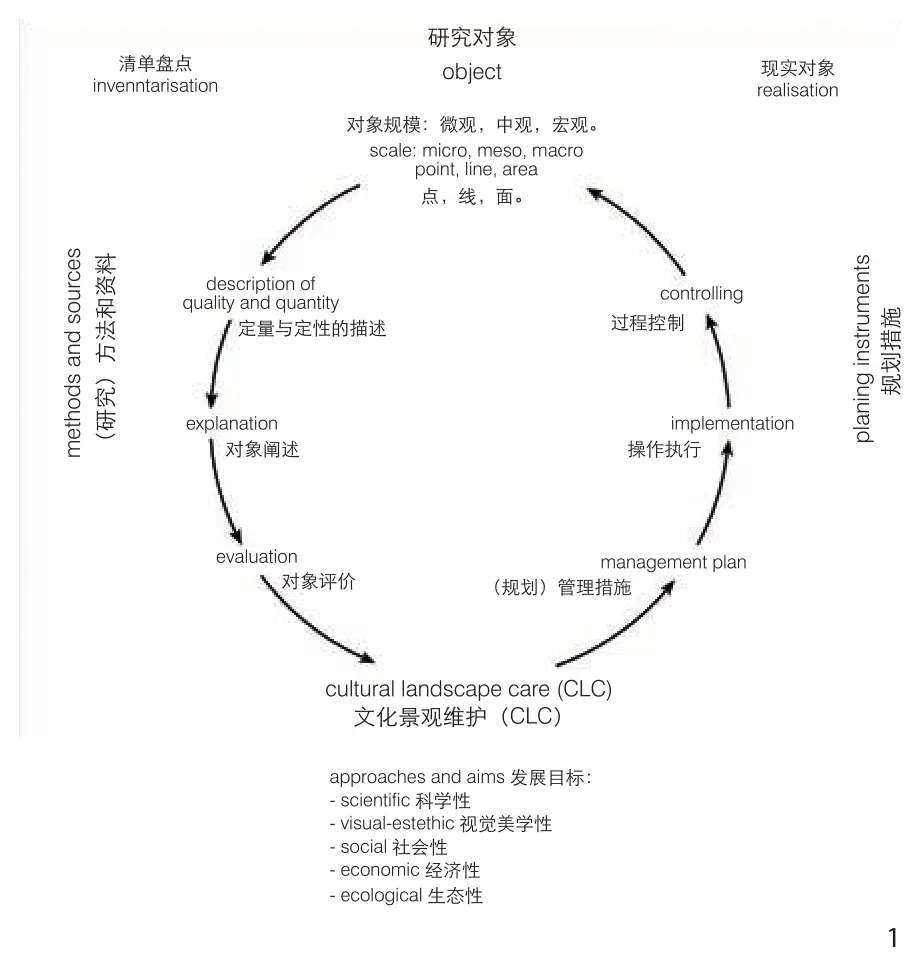
1 “永恒的圆环”:文化景观维护作为一种永恒的论题“Infinite discussion loop”:Cultural landscape conservation as an eternal discourse
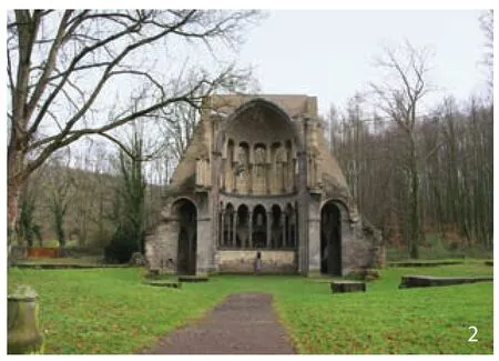
2 前西多会海斯特尔巴赫修道院的唱诗班建筑遗址:Gunzmann的“历史地理群体”对象例子Chorruine of former Cistercian Abbey Heisterbach:An example of historical-geographical group from Gunzelmann

3 自海斯特尔巴赫修道院成立以来一直在使用的历史性田地A historical field that has been in constant use since the founding of the Cistercian Abbey Heisterbach
2个视角均在多年的实践中被反复运用和论证。清单化和区域化是通过内在逻辑联系起来:空间区域化可以作为由对象清单化的“定义性特征”所标识的相对同质性的空间衍生和界定。作为历史性文化景观要素和结构的“定义性特征”可以通过其具体的空间形态加以收集和分析。而历史性文化景观的概念,就是需要借助于清单化的方法,对于对象空间特征进行界定并形成区域化的划分。只有这样的概念确定,才可能在后面的规划过程中,让文化景观对象在使用、保护、维护和未来发展的冲突领域中的矛盾博弈被激发起来。
3.1 范本1:历史性文化景观对象清单化
历史性文化景观的收集与分析是基于文化遗产的空间形态。但一般情况下的文化遗产空间形态的尺度和价值存在很大的模糊性。下面通过示例的方式来说明在实践中被证明的2个历史性文化景观清单分析方法。
清单化示例1:Gunzelmann的清单法[6]:复杂的“历史性文化景观”的分析与分解。
因为(在以往的研究中)假定历史性文化景观对象只能通过其各个组成部分,而不能作为一个整体被收集,所以,历史性文化景观要素的清单最初是通过对各个组成要素的采集进行的。为了使清单化方法可执行,对其研究的内容和时间都做了一些限制。例如,所有史前和早期历史的要素都被排除在外,因为它们是考古学方向的大地保护专业研究内容。同时,很多的城乡住区的建筑形态也不被视为历史遗产建筑保护的对象(图2)。因此,Gunzelmann的方法的一个基本目标是对特别的历史地理群体对象的研究,而这些对象是不属于大地保护专业以及遗产建筑专业研究的对象。
根据Gunzelmann的理论,这些特别的作为历史地理群体对象的文化景观要素和结构的汇总要点:1)获取文化景观的背景信息:自然区域描述、文化景观历史过程、历史村庄结构、历史走廊结构、历史土地利用状况(图3)、历史交通网络状况;2)历史性文化景观要素的收集分类:纪念性建筑、聚落区域、农业区域、商业区域、运输区域、休闲区域、宗教区域、国家—军事区域、关联性文化景观(非物质文化景观);3)通过将各个要素相互联系,对自然因素与历史文化影响力之间的因果关系进行解释,从而对历史性文化景观进行全面了解(图4)。
在此过程中,使用5种方法。1)地图和档案:老地图的取证、历届规划册集以及各种档案的收集。2)文学作品:地方和当地文学、评估特定主题的历史、地理和自然历史文献。3)机构调查:从文物保护局(文物名单)、自然保护局(保护名录)、测量办公室、地质局办公室、农业局办公室和水保护办公室等收集相关数据。4)公民调查:对当地人的调查,如教师、牧师、当地历史学家;询问与文化景观相关的人,如农民或林务员。5)现场调研:绘制、拍摄、描述历史性文化景观要素;将口语化的评价归档为标准化的文化景观要素收集目录。
清单化示例2:Burggraaff和Kleefeld的“文化景观分析”方法[7]。
Burggraaff和Kleefeld受联邦自然保护局(BfN)的委托,在“历史性文化景观和文化景观要素”的研究和开发项目下,根据《德国联邦自然保护法》来编制 “历史性文化景观”的提案。在此研究中,他们创立了“文化景观对象分析”。该方法解决了文化景观研究的一些核心问题,如评价的价值标准和清单化在保护原则指导中的实践问题。
第1步,旨在描述自然环境条件,以便确定相应研究区域的特征。
第2步,在文化景观变化图(图5)的基础上展示文化景观发展过程,以捕捉微小和剧烈的文化景观动态变化。
第3步,在登记表和“历史性文化景观要素地图”中记录历史性文化景观的所有要素。在进行实地工作补充前,应从主管当局(自然保护和文化保护部门)收集已进行测绘记录的要素和结构,并在标准化图册中登记。以缩小的德国基础地图(1∶5 000)为基础,地图要素收集工作在1∶10 000的比例上进行。在此模板上,元素按其外观列为点、线或面。
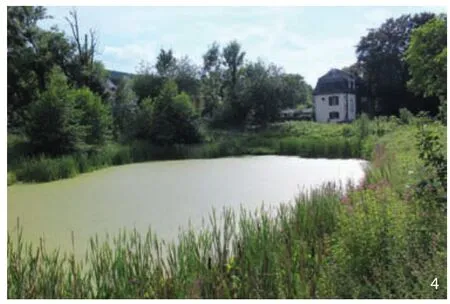
4 在前西多会海斯特尔巴赫修道院环境中重建的池塘Reconstructed pond in the environment of the former Cistercian Abbey Heisterbach
第4步,对文化景观及其要素评估。评估是基于在相应顺序中确定的参数进行的。其中, 历史性文化景观要素和结构最重要的评价参数包括7个方面。1)历史价值(佐证价值):基于要素的年龄及其在起源时的内在含义。2)保护价值:取决于其外部形态的保存状态(原始的、改变的、扩展的、改造的甚至疏远的和腐败的状态)的程度及功能程度(功能性的变化或损失)。3)稀有价值:在确定要素或结构的稀有性时,必须考虑定量的数量和定性的意义。4)区域特性(可标识性)价值:要素是否具有某区域的典型特征或者具备可识别性的价值。5)空间关系和关联性(乡村和城市相关)价值:考虑是否一个要素或结构可以构成一个更大的整体或者更大的区域的一部分,还是仅代表其本身。6)使用价值:决定历史性文化景观要素及结构和(它们的)复合体,在生态、科学、旅游、娱乐方面的意义,另一方面也决定了其未来新功能和用途的意义。7)历史地理价值:不是指个别文化景观要素,而是指面域范围的文化区域和组成部分的整体,其参与到社会发展中并且对区域和国土空间发展起影响作用。
加权的标准由研究机构在法定的框架内决定。 通常,这些标准已经被反复地转换成简单的数字评估级别(或者是分为数字点数,或者将它们分类为“非常好”“好”或“坏”)。虽然,这种简单的数字化加权方法是为了便于理解和简单化选择,然而却模糊了要素之间精确的关联性,没有给出相应的界定。因此,Burggraaff和Kleefeld在这里更倾向于采用恰当的描述性定性评估方法。
同时,他们还提出:如果试图从建立文化景观清单的各种方法中得出一般性结论,则必须确定以下标准:
1)广泛而完整地全面覆盖研究的文化景观区域,对其要素和结构进行精准定位,需要相对较大的比例尺(≤1∶25 000)。 同时,出于分析和实践应用的考虑,也需要将每个文化景观对象划分为点、线和面。另外,由于文化景观是一个连续统一体,因此有必要在一个整体的文化景观背景中对某个单体文化景观要素或结构进行评价分析,并根据规划需要将它们整合到不同维度的大型文化景观单元中。
2)所有相关空间数据的联网:由于大量与文化景观有关的数据的产生。例如:从自然保护和遗产保护名录中获得的数据。而从文化景观维护的角度来看,只有那些有研究价值的并且尚未被收录的要素需要被收录到网络系统。这些需要被收录的对象都是可以被描述为历史性文化景观的要素或结构。在客观需要的情况下,将这些数据与其他空间数据链接。
3)清单应基于地理信息系统(GIS),以便从现有数据库和GIS中导入和导出数据,并不断更新。
总体来说,由于这样的清单化,便有望盘点清楚以前分散的和不太完整的历史性文化景观信息,以缩短规划决策过程,并可以更好地论证和协调规划结论。但是,公共机构(政府部门)的声明和决策不会被(这样的研究结果)取代。
3.2 范本2:历史性文化景观区域化
近年来在文化景观评估领域,出现了从专家角度对历史性文化景观进行标记、注释、分类和简要特征化的方法研究。区域化是基于专家评估的基础上实现的。基本上,区域化可分为2种类型。1)类型化:基于对同质化的区域特征和导则的构建,将一个区域细分为各种历史性文化景观区域。例如:功能意义上的农业或者城市景观区域,历史基因意义上的古老聚落区域,或地貌形态意义上的绿色廊道区域。2)个性化:通过个性化的确定划分出与众不同的区域。空间个体被构建出来,并且通常包含相应的本土个性化名称。例如,汉堡的奥特兰(Alte Land,意为旧土地)地区。
这2种方法都需要强调:没有针对特定目的的区域化研究,只能算是一种学术噱头!因此,研究者需要根据研究尺度,强调各个区域的意义,并确定历史性文化景观区划的基本标准。 这里又有几个问题需要特别强调:
1)区划目标明确吗?哪些具体的顺序,以及依据哪些法律指向了历史性文化景观的区划基本定义?
2)选定的文化景观结构,是否满足指定的历史性文化景观的尺度大小和预期目的?“文化景观”仅仅是被标记了吗?或者选择性地(通过边界线)被注明?表现方式是否适合于每一个(文化景观结构和要素)?
3)是否要做类型学分析?或是否需要尝试命名“文化景观个体”?
4)是要从“上方和外部”(如从鸟瞰角度)还是要“从内部”来解释历史性文化景观?例如, 商业功能的历史性文化景观形成相对均匀空间的标准是什么?有哪些参与者和社会功能构成了这样的空间结构?
5)研究的程序过程是否整体系统化、透明化?是否合乎逻辑?
6)制图表达是否符合清晰度,图形一致性等标准?
7)如果划定的空间对象必须在文本描述中加以论述,那么所使用的材料是否可信和被公开?最后,描述和评估是否独立和相互分离?
在以上这些一般性注意事项下,下面再介绍2个结合实证的区域化范本分析案例。
区域化示例1:前普鲁士领土的文化景观分析。
案例研究所运用的方法是,依据前普鲁士莱茵省的地形图1∶25 000的比较研究[8],按照时间顺序来推导文化景观发展历程。这些地形图是从19世纪10—40年代以及20世纪50—90年代的时间片层。利用这些历史地形图,文化景观的发展从时间由近及远的顺序推演。通过历史推演分析可以发现:在这样的过程中,会有哪些已经消失或死亡或者在所选的时间段内出现过但又消失的文化景观要素和结构;而在那些自19世纪10—40年代以来没有显著变化的区域,却能够高概率地找到历史性文化景观要素和结构。基于这样的结构变化分析,历史性文化景观就可以被解读,并可以被结构性地控制。如果也有19世纪10年代之前的可靠地图资料的话,这样的方法也可以用于更早之前历史推演。
文化景观要素“消失”的影响,可以通过所谓的景观变化状态图来体现。所谓的景观状态变化图也是基于1∶25 000的特殊历史性用地性质图(草地、针叶林、牧场等)或甚至单体要素图(沟渠、道路等)来表达的。它可以是如荒地或森林地区的历史性拓展区域,这些区域在自然保护措施的背景下可能是理想的。基于以上的分析方法,文化景观变化图不仅可以表现历史性文化景观的变化过程,而且还可以引导寻找历史性文化景观要素和结构的高概率区域,以确定其形态结构和历史状态特征。
区域化示例2:对北莱茵—威斯特法伦州的国家发展计划中的文化景观区域化的专题研究。
2007年,北威—利普—莱茵兰景观联盟(Landscape Associations Westphalia-Lippe and Rhineland),受到北威州经济能源创新发展局的委托,负责对国土发展规划(LEP)作出一个文化景观方面的专题研究。该报告的撰稿人遵循上文提到的景观文化遗产保护学会2003年的“历史性文化景观”定义,并以此为基础对北莱茵—威斯特法伦州的国家发展计划进行了基于文化景观区域化的研究工作。
专题研究包含3个基本内容:1)文化景观空间的区域性结构;2)全国性和区域性的重要文化景观区域;3)空间规划导则和目标[9]。
报告撰稿人的讨论方法是基于文化历史领域的视角。报告中文化景观的结构划分的目的是在地区一级的空间单位的范围界定的。这样的界定可以应用于国土和区域规划以及大面积的专业空间规划中。在这样的范围界定中,每个空间区域都应该基于“空间的特殊性”被识别、描述、评估和标注。这种“空间的特殊性”是通过自然空间条件和文化景观发展历史而形成的。同时,区域内的人口与聚落发展,宗教文化历史、社会经济以及政治制度变革等因素也都影响空间特殊性的形成与发展,并且体现在聚落结构、地方性建筑文化价值、历史性建造景观、文保单位以及具有遗产价值的景观空间结构(图6)。
除了制图的表达方式之外,还为每个空间单元制定特征描述,其中主要包括历史塑造的空间形态和考古保护区域。这种文化景观空间划分方法确保了历史性文化景观在空间规划中具备面域特征的意义,这也为国土空间规划及其后续的空间规划和专项规划在技术层面提供了重要前提和基础。最终,在1∶200 000的比例尺下,该区域被分为32个文化景观空间区[9](图7)。
在进一步的工作步骤中,从历史性文化景观的视角确定了具有特殊历史意义的文化景观区域。除了该地区的空间相关性和分布密度之外,还对历史佐证价值、要素保存状态和感知可能性予以特别的关注。因为文化景观区域通常也是发展或者具有特殊性质的区域的典型代表,所以特别需要注意的是什么使得它们与众不同并赋予自身特性[10]。该步骤的目的是:将161个文化景观区域细分为区域发展规划中的优先发展区或者保护区,其中29个区域被确定为具有国家层面重要意义的文化景观区域。运用这样的方法,充分考虑文化景观的内涵意义,可以在国土和区域规划中排除各个文化区域间不相容的用途,而确定具有地方特色和重要意义的区域。
4 总结
通过文化景观维护概念可以把文化景观的历史发展过程看作是各方参与要素互相影响的过程和结果。在此意义上,文化景观维护概念也是一种具有社会协调意义的理论建构,而其适用性也必须在相应的政治文化背景下来加以论证。
基于清单化和区域化的分析方法,可以讨论文化景观要素和结构的收集、评价与保护,以及空间发展导则和规划措施方面的问题。基于以上方法,可以对复杂的“历史性文化景观”的分析与分解(Gunzelmann的清单法),也可以对文化景观不同维度下的价值和空间导则进行分析(Burggraaff和Kleefeld的“文化景观分析”方法),进而可以对区域或者国土空间进行基于文化景观分析的空间区划,从而可以提出对文化景观对象的未来发展措施和目标。具体来讲文化景观对象的保护与发展可分3种[11]:
1)保护性措施:文化景观要素或结构已经部分或整体上不适用于今天的社会经济条件。由于功能性障碍而对其造成了损害,因而有必要恢复其历史性经济用途的保护,从而进行绝对的文化景观保护。
2)维护性措施:对文化景观的要素或结构的空间形态进行保护,可以结合今天的社会经济需要改变和融入适当的使用和功能内涵,其重点在于保持其传统的外在风貌。
3)发展性目标:对于一个区域性的历史文化景观复合体来讲,存在核心价值的概念。此概念也会影响区域的空间导则。在这样的区域文化景观的核心价值概念引导下,文化景观要素或结构的变化与发展则是可以理性分析和控制的。
究竟应该采取哪种方法对文化景观进行研究,取决于收集和分析工作的具体状况。
注释:
① 出自《德国联邦自然保护法》第二章第一节第十四条。
② 出自《德国联邦文化遗产保护法》2017年1月23日修订案。
③ 出自《德国联邦环境监测法》第二章第三节。
图片来源:
图1引自参考文献[2],图2~4由作者提供,图5来自Burggraaff和Kleefeld,图6来自Burggraaff,图7由孔洞一改绘自参考文献[7]。
(编辑/刘玉霞)
1 Research Background
In Central Europe,the following trends in the future development of cultural landscapes can be summarized as follows:1) An increasing differentiation in heavily polluted,dirt areas “from agriculture and state controlled,protected areas”,especially nature and national parks; 2) An accelerated abandonment of agricultural land in the low mountain regions with rich landscape structures and the Alps;3) A further expansion of settlement areas with the consequences of further soil sealing,fragmentation and isolation of biotopes,especially in the densely populated areas; 4) At the same time,the decline in population and degradation of infrastructure,especially in rural areas and around old industrial regions,which can lead to physical decay of urban facilities due to the lack of uses.
Along with the above-mentioned radical changes,traditional images of cultural landscapes integrated with local changes in various regions form a new unification.
As a reaction to this,the field of cultural landscape conservation was developed in Germanspeaking historical geography[1-2]in the 1990s.The field contributes to researches on the conservation and re-development of cultural heritage space,and it also leads the sustainable development of local characteristics within areas and territories.Among which,there are essential approaches in terms of historical-genetic analysis in geography,professional heritage conservation,and spatial planning and regional development,which realizes the cultural landscape conservation and further development researches.
2 Theoretical Basis
The concept of cultural landscape conservation is regarded as an open and dynamic approach to consciously transform and interfere with the external landscape,aiming at the conservation of landscape characteristics and potentials of landscape sustainable development.The objects of cultural landscape conservation are units of historical cultural landscape in the past as well as its cultural landscape elements and structures.In this concept,the research object also contains the meaning of essential featured elements in the regional development,unless its values in the sense of future development are destroyed.
The cultural landscape is the common heritage of mankind,which is not balanced in the density and quantity of regional distribution.This situation leads to many different definitions of cultural landscape concepts in various social contexts.Regardless of various meanings of definitions,the study of the concept cultural landscape conservation is about how to identify cultural landscape objects with both research and conservation values,instead of exploring its conservation methods.In this sense,the basic categories of universal cultural landscape research are regional characteristics and historical authenticity (cultural historical value).They aim to complement the objects with historical geographic values outside the defined range of both nature and heritage conservation recognized by the German society.This concept of cultural landscape conservation in a general sense can be seen in the “infinite discussion loop”,which guides the cultural landscape planning to be conducted according to the following three steps (Fig.1):
1) Collection,description,explanation of cultural landscape in forms of point,line and regional structures and elements through inventories[3]in respective scales and with both qualitative and quantitative methods.On this basis,the historical development process and the development mechanism of the research object could be explained.
2) Cultural landscape conservation and aims.Due to the complexity of “historical/grown” cultural landscape,the evaluation is based on value complex of nature conservation(eg “beauty,distinctiveness,diversity” and uniqueness according to the Federal Nature Conservation Act①),the heritage conservation(historical significance,age value,readability of history according to the heritage conservation law②),and the specific regional requirements of spatial and regional planning③.The principles and development goals of cultural landscape conservation could accordingly include the following points:scientific value,visual aesthetic value,social value,economic value and ecological value.

5 海斯特尔巴赫山谷的文化景观变化Cultural landscape change of the Heisterbach Valley
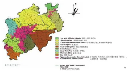
6 北莱茵—威斯特法伦州的文化景观区划Regionalization of cultural landscapes in North Rhine-Westphalia
3) Planning instrument.The derivation of caring measures (of cultural landscape conservation)is oriented towards the understanding that the conservation of historically inherited landscape structures of very old age is only possible in small areas due to high costs and low social acceptance.The cultural landscape conservation as a planning instrument therefore accepts the recognition of constant change as the basic principle of the further development of cultural landscapes,as long as their readability and potential for future developments will not be destroyed in the process.It is possible to continuously develop the characteristics of cultural landscapes and strengthen the cultural landscape awareness,by means of the management and operation of planning process through developing specific planning measures,and the control of internal and external factors related to cultural landscape conversation.Such a process can be carried out steadily and cyclically,and thus forms a conceptual model for the cultural landscape conservation as the “infinite discussion loop”.
The discussions of values,principles and measures should therefore ideally take place in an open,and dynamic manner,particularly,considering the stakeholders,such as farmers and builders,who participate in the cultural landscape discussions.In essence,the cultural landscape conservation is thus a cumulative discourse process of consensus-building to consciously deal with the current transformation processes in our landscapes,and their effects on natural and cultural heritage in order to achieve sustainable development goals.The protected cultural landscape elements and structures will reflect their contribution to regional development in the process of public discussion.In the process,they have spatial factors and structural characteristics which have potentials for further development,and do not have unreasonable effects on the sustainable development of future generations.The term conservation,which is used for the concept “cultural landscape”,thus includes the planning principle of sustainable development.The underlying concept of culture should be open,which means the landscape features and symbolizations beyond the presumed majority cultures also need to be taken into account[4].
In summary,the cultural landscape conservation is practice-oriented,legally required and directly applicable.The general meaning of resource protection here refers to:biodiversity conservation,maintenance of landscape aesthetics,strengthening of local identity,creation of livable environment,and economic diversification and value innovation.
It must be pointed out that the cultural landscape conservation is primarily concerned with the historical cultural landscape.In the 24th session of the Subcommittee “Preservation of Historic Monuments” (UAD) of the Conference of the Ministers of Culture (KMK) on 19-20 May 2003 in Görlitz,a definition of “historical cultural landscape” was agreed[5]:“The historical cultural landscape is a part of the current cultural landscape,which is characterized by historical,archaeological,art-historical or cultural-historical elements and structures.” The historical cultural landscape is thus a theoretical construct,in particular of an analytical focus on the recording,explanation and evaluation of historical heritage in landscapes.
3 Inventory and Regionalization as Basic Tasks in the Context of Cultural Landscape Conservation
With regard to the historical cultural landscape,there is a clear definition in the relevant academic circles in Germany,while implications also exist in the documents of other European countries.In general,researches on historical cultural landscape include two analytical tasks:1) Inventory:Comprehensive recording,analysis and evaluation of historical cultural landscape elements and structures as “defining features”;2) Regionalization:The characteristic areas of historical cultural landscapes are marked and defined as featured cultural areas within the regions and national boundaries.
For each of these two aspects,two examples proven for years in practice will be given in the following.Inventory and regionalization are combined by the fact that regionalization can be a purposive spin-off through identifying relatively homogenous spaces with a specific combination of “defining features”.The “defining features” are analytically tangible as historical landscape elements and structures.It is only through this recourse to the object level that phrases such as “historical cultural landscape” can be implemented in the planning,because the objects ignite conflicts of interest concerning the tension of use,protection,maintenance and further development.
3.1 Task 1:Examples of Planning-related Inventories of Historical Cultural Landscapes
The collection and analysis of historical cultural landscape is based on the spatial form of cultural heritage which generally has its ambiguity in terms of scale and value.Two concepts of inventory proven in practice are presented below as examples.
Inventory Example 1:The Inventory Approach According to Gunzelmann[6]:Analysis and Decomposition of the Complex “Historical Cultural Landscape”.
The inventory of historical cultural landscape elements initially takes place via a physiognomic assessment of the individual elements,since it is assumed that the historical cultural landscape could not be captured as a whole,but only through its individual components.In order to make the inventory method executable,there are some restrictions on the research content and time.All elements from prehistoric and early historical periods are excluded from consideration,since they are objects of archaeological ground conservation.Furthermore,the spatial structure of urban and rural settlements as a content of historical preservation is not considered (Fig.2).Thus,an essential goal of Gunzelmann’s approach is to highlight a specific historical-geographical group of objects and is not responsible for the ground conservation and the protection of architectural heritage.
According to Gunzelmann,the recording of the following structures is established:1) Collection of the foundations of the cultural landscape:Natural environment - Cultural landscape history- Historical village structure - Historical corridor structure - Historical land use (Fig.3) - Historical traffic network.2) Collection and description of the elements of the historical cultural landscape:Monuments - Settlement area - Agriculture area -Commercial area - Transport area - Leisure area-Religion,State and Military area - Associative Cultural Landscape.3) Overall view of the historical cultural landscape through networking of the individual elements with each other and explanations of interactive effects between the natural factors and the historical influence (Fig.4).
The following methods are used.1) Maps and archives:collection of old maps,previous plans,and files; 2) Literary work:evaluation of local and regional literature; Evaluation of subject-related historical,geographical and natural history literature; 3) Authority inquiry:Elicitation of relevant planning data from the monument authority (monument list),the nature conservation authority (“red list”),the land surveying office,the geological state office,the agricultural office and the water management office; 4) Citizen Survey:survey of local people such as teachers,pastors,local historians;Questioning people associated with the cultural landscape,such as farmers or foresters; 5) Site inspection:mapping,photographing,describing historical cultural landscape elements; segregating verbal assessment according to a standardized catalog.
Inventory Example 2:“Cultural Landscape Substance Analysis” according to Burggraaff and Kleefeld[7].
Under the research and development of“Historical Cultural Landscape and Cultural Landscape Elements”,Burggraaff and Kleefeld[7]were commissioned by the Federal Agency for Nature Conservation (BfN) to develop proposals for the implementation of the “historical cultural landscape” in accordance with the Federal Nature Conservation Act.From this catalog of methods,the “cultural landscape substance analysis” should be selected and explained here,as it reveals fundamental problems such as the application of value standards and the implementation of inventories in the guidance of conservation principles.
The first step aims at the description of the natural environment in order to characterize the study area.
The next step is to display the cultural landscape development on the basis of a cultural landscape changing map (Fig.5) to capture the tiny and dramatic dynamics of cultural landscapes.
The third step is to create an inventory of all elements of historical cultural landscape in the registration sheet and in the “Map of Historical Cultural Landscape Elements”.Before this is supplemented by their own field work,those already mapped elements and structures from the responsible authorities (conservation and conservation authorities) are queried and recorded in the template.The mapping itself is carried out on a scale of 1∶10,000 on the basis of the downsized German base map (1∶5,000).On this template,the elements are listed according to their appearance as a point,line or area.
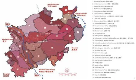
7 北莱茵—威斯特法伦州的32个文化景观区32 cultural landscape areas in North Rhine-Westphalia in Germany
For the fourth step,the assessment of cultural landscape and its elements needs to be made.The evaluation is made according to the parameters determined in the respective order.The most important evaluation parameters of historical cultural landscape elements and structures are as follows:1) The historical value(evidence value) is based on the age of the element and its significance during the time of its creation.2) The conservation value is determined by the level of its formal external conservation status(original,altered,extended,remodeled and even alienated and falsified status) and the level of its functionality (functional change or loss).3) The scarcity value:When determining the scarcity of an element or structure,both the quantitative number and the qualitative significance must be taken into account.4) The typical value of the region (identity) is about the question of whether the element is typical for a region and has a value that creates identity.5) The value of the spatial relationships and connections (landscape and urban related) needs to consider whether an element forms part of a larger ensemble or area or only stands by itself.6) The value of use determines the significance of historical cultural landscape elements,structures and complexes for ecology,science,tourism,recreation on the one hand,and for new functions and uses,on the other hand.7) The historical-geographical value does not refer to individual elements,instead it means extensive cultural landscape areas and components,which participate in society and effect regional and rural development.
In the investigation,which criteria should be applied and with which weighting,is determined by the statutory framework.Repeatedly,such criteria have been transformed into simple numeric grades(either awarding points or classifying them as “very good,” “good,” or “bad”).This is a practical way to make it more comprehensible.But an exactness is simulated by this,which is not given.Burggraaff and Kleefeld therefore were inclined to adopt appropriate descriptive and qualitative assessment methods.
If one tries to draw general conclusions from the approaches of establishing cultural landscape inventories,the following standards must be defined:
1) Extensive and complete coverage of cultural landscape features and structures with a precise localization of them,which requires a corresponding large scale (≤ 1∶ 25,000).At the same time,for analytical and practical reasons,it is first necessary to divide the cultural landscape into its individual components of punctate,linear and planar forms.However,as the cultural landscape is a continuum,it is then necessary to evaluate the individual findings in their cultural landscape context and integrate them into larger cultural landscape units of different dimensions depending on the planning needs.
2) Networking of all relevant spatial data:a large number of cultural landscape related data,which are obtained through the lists of both nature and heritage conservation,will be produced.From the perspective of cultural landscape conservation,only those that have not yet been systematically recorded need to be added later.These are especially elements and structures that can be described as historical cultural landscape relics.These data are linked with other spatial data.3) The inventory should be based on a Geographical Information System (GIS) to enable the import and export of data from existing databases and GIS,as well as their constant updating.
Overall,because of this inventory method,previously scattered and incomplete historical cultural landscape information could be summarized in order to shorten planning decisionmaking processes and to better substantiate and coordinate propositions.However,the statements of the public authorities are not thereby replaced.
3.2 Task 2:Examples of Regionalization of Historical Cultural Landscapes
In recent years,in the field of cultural landscape assessment there have been methods for marking,annotating,classifying and briefly characterizing historical cultural landscapes from the perspective of experts.Basically,two types of regionalization can be distinguished:1) Typifications:An area is subdivided into historical cultural landscapes by constructing relatively homogeneous spaces based on certain characteristics and criteria,e.g.Agricultural or urban landscapes in a functional sense,old settlements in a historical-genetic sense,hedgerow landscape in a physiognomic sense.2) Individualizations:Areas that stand out from others through their individuality could be identified.Thus,spatial individuals are constructed and often provided with correspondingly individual names,e.g.the “Alte Land (Old Country)” near Hamburg.
It should be applied for both approaches:the Regionalization without orientation to a specific purpose are academic gimmicks.Therefore,depending on the scale,it is important to emphasize the respective levels of meaning and to disclose the underlying criteria for marking historical cultural landscapes.In particular,these questions need to be asked:
1) Is the goal setting clear? What is the specific order? And which laws will point to the basic definition of the zoning of historical cultural landscapes?
2) Does the selected cultural landscape structure ensure the intended purpose with regard to the scale and size of the designated historical cultural landscapes? Are “cultural landscapes”merely marked or carefully identified (e.g.by borderlines) and is the representation method appropriate?
3) Should a typological analysis be conducted,or “cultural landscape individuals should be named”?
4) Should the historical cultural landscapes be constructed from “above and outside” (as if from a bird’s-eye perspective) or “from the inside”,e.g.about acting and actors? What are the criteria for forming relatively homogeneous spaces?
5) Is the procedure overall systematic,transparent and logical?
6) Do the cartographic representations meet criteria such as clarity and graphical consistency?
7) If the delineated units are accurately characterized in the - absolutely necessary - textual description,is the used material disclosed and,finally,are descriptions and evaluations clearly separated from each other?
From the background of these general considerations,two methods which were proven from planning practices for the designation of historical cultural landscapes are presented below.
Regionalization Example 1:Cultural landscape changing maps for the territory of the former Prussia.
The aim of this method is the chronological representation of the development of the cultural landscape based on comparisons of the Topographic Map 1∶25,000 in the former Prussian Rhine Province[8].They are from periods of 1810/1840 to 1950/1990.On this basis,the development of the cultural landscape is chronologically presented to the most recent situation.In this process,some landscape elements and structures are lost,some have arisen and disappeared again between the selected time periods.However,it is even more obvious that the areas without changes since 1810/1840,thus have the highest probability of finding historical elements and structures.Based on the above analyses,historical cultural landscapes are controlled and comprehensibly constructed.If there was also reliable map data before 1810,this method could also be used for earlier historical deductions.
The effect of the “disappearance” of elements can be caught by the making of socalled landscape state changing maps,which - also on the basis of the TK 25 - represent special old uses (grassland,coniferous forest,heather etc.) or even individual elements (trenches,paths,etc.).It can record e.g.the historic extent of heathland or forest areas,which may be desirable in the context of nature conservation measures.Thus,cultural landscape changing map not only appears as a means of showing historical cultural landscapes,but also describes areas with a high probability of finding historical elements and structures.
Regionalization example 2:Special research on the State Development Plan of North Rhine-Westphalia.
In 2007,the regional associations of Westphalia-Lippe and Rhineland were commissioned by the Ministry of Economic Affairs,Mittelstand and Energy North Rhine-Westphalia,which is responsible for regional planning,to present a cultural landscape document to the State Development Plan.Their editors followed the definition of the term “historical cultural landscape” according to cultural committee since 2003,which has been mentioned above.
The Special research contains three essential parts:firstly,an comprehensive structure in cultural landscape areas,secondly nationwide and regionally significant cultural landscape areas,and thirdly,spatial planning concepts and objectives[9].
The approach,which is used by the report editors,is based on a cultural-historical perspective.The aim of the cultural landscape structure was a comprehensive result in space units on a regional level,which makes them applicable for state and regional planning as well as large-scale specialized planning.The respective space should be identified,described,evaluated and marked.Substantive criteria were based on the particular character of a space,which is characterized by natural conditions and the cultural landscape development,and also shows the development of settlement history,territory,religion and economy as well as the influences in land use patterns,settlement structures,evidence of regional construction culture and historic house landscapes,the features of cultural monuments and monumental structures as well as the landscape image (Fig.6).
In addition to the cartographic representation,a description of characteristics was formulated for each space unit,which mainly includes historical spatial forms and archaeological protection areas.This method of spatial division of cultural landscapes ensures the significance of historical cultural landscapes in the spatial planning,which also provides important prerequisites and foundations from a technical aspect for the national spatial planning and subsequent spatial planning and special planning.Ultimately,32 cultural landscape spaces could be summarized and marked on a scale of 1∶200,000 (Fig.7)[9].
In a further step,the cultural landscape area with special historical significance is identified from the perspective of historical cultural landscape.In addition to the spatial correlation and distribution density of the region,special attention is paid to historical evidence values,conservation state of factors,and perceived possibilities.Since the cultural landscape areas are often particularly typical of a development or of a particular characteristic,special attention was paid to what makes them distinguishable and gives them their own character[10].The aim is to present the 161 cultural landscape areas,29 of which are of national significance,as priority or reserved areas in the state development plan; In this way incompatible uses should be excluded and necessary cultural landscape concerns should be given special consideration.
4 Conclusion
In summary,historical development process of cultural landscapes could be regarded as the process and result of mutual influence of various factors of participation in the sense of cultural landscape conservation.In this sense,the concept of cultural landscape conservation is a theoretical construction with social coordination significance,and its applicability must be demonstrated in the corresponding political and cultural background.
Finally,on the basis of the inventories and regionalization,the collection,evaluation,protection of cultural landscape elements and structures,as well as space development guidelines and planning measures could be discussed.Based on the abovementioned methods,the complex “historical cultural landscapes” could be explained (Gunzelmann’s inventory approach),and the values and spatial guidelines of cultural landscape in various dimensions could also be analyzed (Burggraaff and Kleefeld’s“cultural landscape analytical approach).In addition,spatial zoning based on cultural landscape analysis could be carried out on the regional or national land space,so that future development measures and goals for cultural landscape objects could be proposed.The protection and development of cultural landscape objects could be concluded specifically as follows[11]:1) Conservation measures:Cultural landscape elements or structures are not partially or integrally applicable to today’s socio-economic conditions.Due to damages caused by functional barriers,it is necessary to restore the protection of historical economic uses for absolute cultural landscape conservation.2) the maintenance means to protect the spatial forms of elements or structures of cultural landscapes,combined with today’s socio-economic needs to change and integrate appropriate uses and functional connotations,with a focus on maintaining the traditional “external appearance”.3) Development goals:For a regional historical and cultural landscape complex,there is a concept of “core value” affecting the spatial guidelines of the region,under which the changes and development of cultural landscape or structures could be analyzed and controlled rationally.
And which method should be used to study the cultural landscape depends on the specific conditions of collection and analysis work.
Notes:
① Bundesnaturschutzgesetz (25.3.2002):§ 2,Abs.1 Nr.14.Bonn:Der Bundestag,2009.
② Gesetzzum Schutzder Kulturdenkmale(Denkmalschutzgesetz -DSchG) zuletzt geändert durch Artikel 37 der Verordnung vom 23.Februar 2017 (GBl.S.99,104).
③ Gesetz über die Umweltverträglichkeitsprüfung(18.6.2002):§2 Nr.3.
Sources of Figures:
Fig.1 ©Reference [2],Fig.2-4©authors of this papre,Fig.5 ©Burggraaff and Kleefeld,Fig.6 © Burggraaff,Fig.7©Reference [7],modified by Kong Dongyi.
