Impacts of degrading permafrost on streamflow in the source area of Yellow River on the Qinghai-Tibet Plateau, China
2019-06-11MAQingJINHuiJunVictorBENSELUODongLingSrgyMARCHENKOSturtHARRISLANYongCho
MA Qing, JIN Hui-Jun*, Victor F. BENSE, LUO Dong-Ling,Srgy S. MARCHENKO, Sturt A. HARRIS, LAN Yong-Cho
a State Key Laboratory of Frozen Soils Engineering, Northwest Institute of Eco-Environment and Resources, Chinese Academy of Sciences, Lanzhou, 730000,China
b College of Resources and Environment, University of Chinese Academy of Sciences, Beijing, 100049, China
c School of Civil Engineering, Harbin Institute of Technology, Harbin, 150090, China
d Hydrology and Quantitative Water Management Group,Department of Environmental Sciences,Wageningen University,Wageningen,6708PB,the Netherlands
e Geophysical Institute (GIPL), University of Alaska Fairbanks, Fairbanks, 99775, USA
f Department of Geography, University of Calgary, Calgary, T3A 1E4, Canada
Abstract Many observations in and model simulations for northern basins have confirmed an increased streamflow from degrading permafrost,while the streamflow has declined in the source area of the Yellow River(SAYR, above the Tanag hydrological station)on the northeastern Qinghai-Tibet Plateau,West China.How and to what extent does the degrading permafrost change the flow in the SAYR?According to seasonal regimes of hydrological processes,the SAYR is divided into four sub-basins with varied permafrost extents to detect impacts of permafrost degradation on the Yellow River streamflow.Results show that permafrost degradation may have released appreciable meltwater for recharging groundwater.The potential release rate of ground-ice melt-water in the Sub-basin 1(the headwater area of the Yellow River(HAYR),above the Huangheyan hydrological station) is the highest (5.6 mm per year), contributing to 14.4% of the annual Yellow River streamflow at Huangheyan.Seasonal/intra- and annual shifts of streamflow, a possible signal for the marked alteration of hydrological processes by permafrost degradation, is observed in the HAYR, but the shifts are minor in other sub-basins in the SAYR. Improved hydraulic connectivity is expected to occur during and after certain degrees of permafrost degradation. Direct impacts of permafrost degradation on the annual Yellow River streamflow in the SAYR at Tanag,i.e.,from the meltwater of ground-ice,is estimated at 4.9%that of the annual Yellow River discharge at Tanag,yet with a high uncertainty, due to neglecting of the improved hydraulic connections from permafrost degradation and the flow generation conditions for the ground-ice meltwater. Enhanced evapotranspiration, substantial weakening of the Southwest China Autumn Rain, and anthropogenic disturbances may largely account for the declined streamflow in the SAYR.
Keywords: Streamflow; Warming climate; Permafrost degradation; Streamflow patterns; Source area of Yellow River (SAYR)* Corresponding author. State Key Laboratory of Frozen Soils Engineering,Northwest Institute of Eco-Environment and Resources,Chinese Academy of Sciences, Lanzhou, 730000, China.
1. Introduction
Many recent studies have reported an increased streamflow due to degrading permafrost in northern basins(e.g.,Ge et al.,2013; Bring and Destouni, 2014; Haine et al., 2015; Bring et al., 2016, 2017; Kurylyk et al., 2016), as well as many permafrost basins on the Qinghai-Tibet Plateau (QTP) (e.g.,Ye et al.,2012;Han et al.,2016;Gao et al.,2018;Wang et al.,2018a; Xu et al., 2019). However, in the source area of the Yellow River (YR) (SAYR, above Tanag (TNG), Qinghai province, West China), with a widespread presence of discontinuous, sporadic and patchy permafrost and seasonal frost (Jin et al., 2009), which are vulnerable to climate warming. A declined streamflow has been detected in spite of a slightly increasing precipitation (0.3 mm per year) during 1961-2017.
Since 1976, annual mean air temperature (AMAT) in the SAYR has been increasing rapidly (0.39°C per decade),almost twice as rapidly as the global average warming rate(0.2°C per decade) (IPCC, 2013). The SAYR has also undergone significant climate warming, which is greater than some other sub-regions on the QTP (Cheng et al., 2019).Borehole data and observations also show progressive ground warming (0.19°C per year) in 2010-2016 at Xingxinghai in the upstream SAYR (Luo et al., 2018). Elevation of the lower limit of permafrost (e.g., 4320-4370 m a.s.l. at Yeniugou on the northern slope of the Bayan Har Mountains) (Jin et al.,2009), shrinkage of the areal extent of permafrost, and declined maximum depth of seasonal frost penetration(3.5 cm per decade) (Qin et al., 2017; Luo et al., 2018; Wang et al.,2018b; Zheng et al., 2019) are frequently reported in the SAYR above TNG.
The SAYR,one of the key Asian Water Towers,covering a catchment area of 16.2% of the Yellow River Basin(752.4 × 10³km2), but providing about 54.7%(20.0 × 10⁹m3at the TNG) of the multi-year average of annual discharge (36.5 × 10⁹m3 at the Lijin hydrological station in Shandong province,East China)of the Yellow River to the Pacific Ocean (CMWR, 2008-2017), is disproportionally important for the basin-wide YR flow regimes.Decreasing surface water resources and three recorded dry-ups of YR streamflow in the upstream SAYR in 1980, 1988 and 1995 have caused extensive and intense concerns in China and abroad.
Because of intricate nature of changing trends and mechanisms of flow regimes in cold regions, some recent research have tried in revealing,quantifying,or attributing the impacts of permafrost degradation on/to the decreased YR flows(e.g.,Lan et al.,2015;Niu et al.,2016;Xu et al.,2016;Wang et al.,2017,2018c,2018d;Wu et al.,2018).They have explored the impacts of permafrost degradation on the YR discharge by methods of identifying the increase in groundwater storage(e.g., Niu et al., 2016; Xu et al., 2016; Wang et al., 2017), or mathmatical model simulations to decompose the streamflow components (e.g., Budyko framework or mathmatical model)(Wang et al., 2018c; Wu et al., 2018). Employing a processbased Variable Infiltration Capacity model, Lan et al.(2015) tried in explaining the effect of degrading permafrost on surface hydrology. Yet, conclusions are mixed and mostly derived from relationship analysis for water-balance items. The impacting mechanisms of degrading permafrost on hydrological processes are hardly examined.The questions as how, and to what extent, permafrost degradation would alter the streamflow regimes in the SAYR, remain unanswered.
In this study, we discuss the mechanisms for hydrological impacts of permafrost degradation and quantitatively examine major impacting mechanisms for the YR streamflow with accessible and reliable long-term observational data. Knowledge of seasonal regimes in hydrology is applied and season is re-divided according to the hydrogeological and hydrological features of the SAYR catchment. Corrections of precipitation,evaporation and YR streamflow are made for obtaining the actual values of water-balance components. Focusing on the hydrological impacts, on the YR streamflows in particular,from degrading permafrost, these studies are key to understanding the water cycles and water resources in the upper Yellow River Basin and important for water supply and safety in the YR Basin.
2. Study regions
The SAYR, i.e., the catchment of the Yellow River (YR)Basin above TNG (32°10′-36°7′N, 95°54′-103°24′E;2629-6253 m a.s.l.) on the northeastern QTP, has a catchement area of 120,900 km2. For comparison, the SAYR is divided into four sub-basins with varied permafrost extents and other basin characteristics by four major hydrological stations on the YR mainstream as follows: Sub-basin 1 (the headwater area of the Yellow River (HAYR), above Huangheyan hydrological station, abbreviated as HHY), Sub-basin 2 (between HHY and Jimai (JM)), Sub-basin 3 (between JM and Maqu¨ (MQ)), and Sub-basin 4 (between MQ and TNG)(Fig. 1). The landscape of the SAYR is characterized by lowrelief valleys surrounded by high mountains, as a result of collision of the India Plate with the Asia Plate, forming extensive strike-slip and normal faults (Lutgens and Tarbuck,2012). Due to the low-relief valleys, stream channels in the Sub-basin 1 (HAYR) are largely braided and meandering (Jin et al., 2009). The Sub-basin 2 enters high-relief gorges of the A'ny^emaq^en Mountains, where stream channels are deeply incised.In the Sub-basin 3,a knickpoint induces an abrupt loss of streamflow momentum and change its flow direction,forming meandering rivers and tributaries and numerous paleo-river channels on the Zoıˆg´e Plateau. In the Sub-basin 4,stream channels are deeply cut and laterally constrained. Due to extensive glaciations, wind and river processes since the Pleistocene, fluvial-alluvial, aeolian and glacio-lacustrine sediments are widely deposited in the SAYR (Blue et al.,2013).
Only 166 contemporary glaciers present at elevations of 4400- 6000 m a.s.l. in the A'ny^emaq^en Mountains, with an areal extent of ~126.7 km2, and; glacier-melt contributes only 1%-2% of annual discharge at TNG (Blue et al., 2013;Jin et al., 2019). Alpine meadows and steppes prevail in the HAYR.In lower catchments, shrubs and forests start to appear in patches.The Zoıˆg´e Plateau in the Sub-basin 3 is characterized by extensive occurrences of wetlands and aquatic vegetation,with peat layers as deep as 5.0-10.5 m in some areas. Along the southeastward declining elevational and climate gradients,discontinuous, sporadic and patchy permafrost and seasonal frost occur cascadingly downwards. Influenced by regional and local climate conditions, the relatively humid climate in southern and eastern SAYR results in more ice-rich permafrost and widespread wetlands, while it is more arid in northern SAYR,with widespread occurrences of mobile sand dunes and sand-lands (Blue et al., 2013).
In 1998-2003,the First SAYR hydropower station(FSHS,also called the Ng¨oring Lake Reservoir), was built for Madoi county town in the Sub-basin 1 (HAYR). In 2007, the Pandoh hydropower station was built in the Sub-basin 4 and subsequently put to operation (Fig. 1). Additionally, in the Subbasin 4, some smaller dams, as Moduo, Dangcun and Gaqu dams (Fig. 1), were also built for power generation, domestic usage and irrigation. These reservoirs alter spatial and temporal distributive features of the YR streamflows and promote domestic usage and agricultural irrigation, subsequently reducing the YR streamflow. More detailed information is presented in Table 1.
3. Materials and methods
3.1. Data acquisition
The data of monthly YR streamflow in the SAYR are collected at the above mentioned four hydrological stations(HHY,JM,MQ and TNG).Thus,the YR streamflow generated in each sub-basin is obtained by subtracting the streamflow at the last upstream hydrological station from that at the control station in this sub-basin. Data for daily temperature, precipitation, wind speed and evaporation (20-cm-pan) are downloaded from the National Meteorological Information Center of China Meteorological Administration (http://data.cma.cn).The period of meteorological data extended for 57 hydrological years from November 1961 to October 2017. A hydrological year is set from November to the next October on the basis of regimes in monthly average air temperature,precipitation and flow. Yearly data here all refer to those hydrological years. Areal extent of permafrost is extracted from Ran et al. (2012) and/or Brown et al. (2002). Permafrost thickness and ground temperature data are from in-situ borehole monitoring. Digital elevation model (DEM) is downloaded from https://earthexplorer.usgs.gov/and hydrology module in ArcGIS is employed to obtain the basin boundary.
3.2. Analytical methods
The hydrological data in the SAYR were validated by employing the method of Double Mass Curve(DMC)(Searcy and Hardison, 1960). In this method, data are reformatted by adding all data up before this datum in time series of control and validated stations. Then, the reformatted data are plotted as x- or y-coordinates.
Daily precipitation data are measured by Chinese standard precipitation gauge (CSPG) for measuring liquid and solid precipitation at national meteorological stations. A systematic error occurs by employing CSPG, especially in cold environments (Ye et al., 2004; Yang et al., 2005). Wetting loss, evaporation loss, and trace precipitation and wind-induced gauge under-catch are taken into account of when validating daily precipitation data in the SAYR according to Ye et al. (2004).
It is found the annual evaporation data of 20-cm pan measured at meteorological stations in the SAYR are about 2.5 times larger than the estimated actual evaporation by Gravity Recovery and Climate Experiment(GRACE)satellite data and intra-annual variability differs between these two evaporation datasets (Xu et al., 2013). The inter- and intra-annual variability of evaporation among four sub-basins is similar and modulated according to the estimated actual evaporation by GRACE.Inter-monthly,-seasonal and-annual trends of major hydrometeorological variables in each sub-basin and in the SAYR were obtained by linear regression analysis.
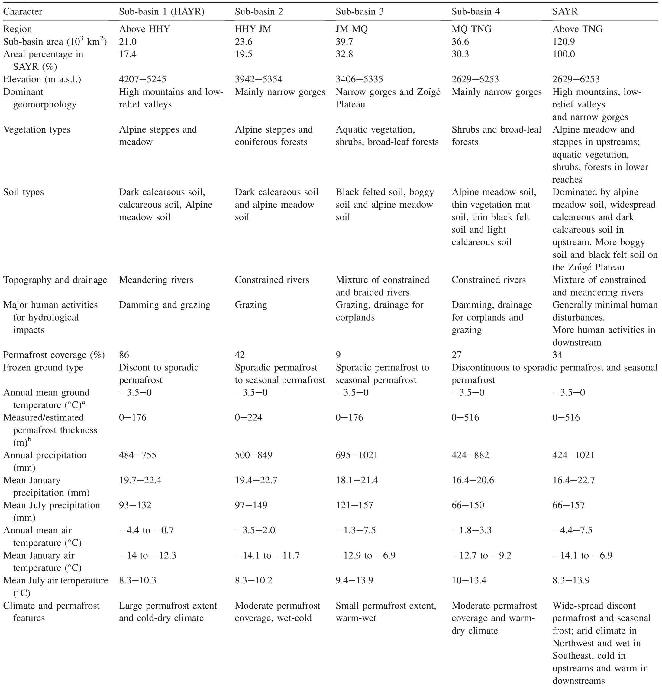
Table 1 Climate,geomorphology,permafrost and vegetation characteristics in four sub-basins in the source area of Yellow River(SAYR)on northereastern Qinghai-Tibet Plateau.
3.3. Seasonal division in sub-basins
Hydrological processes are strongly featured by seasonality. In winter when everything on ground surface is immobilized by cold weather, ground freezing and snow cover,streamflow in permafrost regions are mainly recharged by groundwater (Woo, 2012). In spring, snow cover begins to melt and the snow-melting is accompanied by intermittent spring snowfall and/or rainfall,and streamflow gradually picks up. The spring streamflow is mainly correlated to winter and spring precipitation input and near-surface hydrological processes(Woo,2000;Neff et al.,2006).In summer and autumn,high precipitation input dominates the streamflow, which depends on the balance between evaporation and rainfall (Carey and Woo, 2001a, 2001b). However, the common division of four seasons appears unreasonable for alpine and Arctic regions since different watersheds have a varied duration of hydrological seasons(Takeuchi et al.,2004;Yang et al.,2009;Ye et al., 2009).
By taking into account of features in multi-year averages of mean monthly air temperatures, precipitation and streamflow in each sub-basin of the SAYR, it is found that precipitation largely synchronizes with air temperature. In the HAYR (the highest and coldest sub-basin in the SAYR), the period of subzero monthly mean air temperature (MMAT) occurs from November to April in comparison with the period of November to March in other three sub-basins. In the subsequent two months (May-June for the HAYR and April-May for Sub-basins 2, 3, and 4), MMAT turns above zero and the YR streamflow keeps low, but shows a slight pickup. In summer and autumn, MMAT goes the highest in the year and precipitation and streamflow peaks largely correspond to rainstorms. Despite of different duration of seasons between the HAYR and other sub-basins, shifts in streamflow in each season and their reponses to changes in precipitation and evaporation are detectable in each sub-basin.The hydrological seasons are thus divided as follows:
1) Winter season (November to next April in the HAYR,and November to next March in Sub-basins 2, 3, and 4)captures the low streamflow and subzero MMAT.
2) Spring season is from May to June in the HAYR and from April to May in Sub-basins 2, 3 and 4. Air temperature begins to go above 0°C.The snow cover in winter starts to melt,and occasional rainfall may initiate near-surface hydrological processes with increasing thaw depth.
3) Summer season (July-August in the HAYR;June-August in Sub-basins 2, 3 and 4) captures the large amount of precipitation and higher temperatures in a year. In summer, rainstorms dominate in-stream streamflow.
4) Autumn season (September-October) captures the similar hydrological precesses as summer season. A second peak rainfall(in autumn)in a year is well-known in China as Southwest China Autumn Rain (Bai and Dong, 2004).
3.4. Flow data validation
Except for actual evaporation and precipitation, reliable streamflow data are critical for analyzing the impacts of permafrost degradation on the YR streamflow in the SAYR.Zhang et al. (2004) found close relationships among the streamflow data at four hydrological stations in the SAYR and the DMC analysis revealed a particular inclination among four hydrological stations. Fig. 2 indicates that, since 1998, the construction of the FSHS has largely altered the YR streamflow at HHY.
Since January 1998 when the FSHS began to build,the DMC started to go downwards due to the damming of stream channel for construction work. The FSHS was put to operation in February 2000 and the curve went upward for a short period(February 2000 to December 2002). Then, the FSHS stopped functioning from January 2003 to June 2005,due to the abnormally low flow,or dry-up.During these periods,the uncorrected cumulative curve went much smoother,almost horizontal,due to continuous impoundment of water in the reservoir.
The FSHS was again put back to operation in June 2005.Since 2007, precipitation began to increase notably and incoming water to the reservoir was mostly discharged.During the period between January 2007 and September 2016,there was a trend for the YR discharge to return to its original inclination before January 1998. Since October 2016, the State Grid has been supplying electricity for Madoi county town and the power generation of the FSHS has been suspended. As a result, inclination of cumulative curve has gone smooth again. Thus, in wetter years, the FSHS, with only a limited storage capacity, discharges most incoming water. However, in drier years, the reservoir management prefers to the impoundment of water,and smaller-than-normal streamflows are measured.

Fig.2.Double mass curve (DMC)between the Huangheyan(HHY)and Jima(JM)hydrological stations for correcting the Yellow River(YR)discharge at HHY near Madoi, Qinghai province on the northeastern Qinghai-Tibet Plateau.
The streamflow data at HHY are corrected for the period since the construction of the FSHS dam(January 1998) to the turning point of returning to its original inclination (January 2007)and the period between October 2016 and October 2017(in blue color). The FSHS is planned to be totally dismantled due to the eco-environmental concerns and as a partial effort of establishing the Three-Rivers Source Area National Park of China.The removal of the dam may help the cumulative DMC curve restore to its original shape.
4. Effect of permafrost degradation on YR streamflow in the SAYR
4.1. Melting ground ice
The melting of excess-ice in permafrost soils may release a certain amount of meltwater in favorable flow-generation environments (O'Donnell et al., 2016). Wang et al. (2018a)roughly estimated the average volumetric ice content of permafrost in the SAYR above Duoshixia (34°34′42′′N,98°19′24′′E;4197 m a.s.l.)at 0.31±0.11 m3m-3.This can be employed as the average for that of the SAYR because the major portion of permafrost in the SAYR is found above Duoshixia. Wang et al. (2018b) projected that most of the permafrost in the SAYR would thaw by 2100 under the RCP 4.5 scenario. Thus, the potential average release rate of ground-ice meltwater was roughly estimated by Eq.(1),due to the data gap for accurate estimation of ground-ice meltwater in the SAYR:

where Rimis the average release rate of ground-ice meltwater in mm per year; PA is permafrost area in km2; C is the areal continuity of different permafrost types (continuous permafrost: 0.95, discontinuous permafrost: 0.7, sporadic permafrost: 0.3, isolated patches of permafrost: 0.05) (Brown et al.,2002), dimensionless; D is the thickness of permafrost with ground ice occurrence in m; Ciceis average volumetric ice content at the given depth range in m3m-3; CA is catchment area in km2, and; T is projected time span of permafrost disappearance in year.
The potential average release rate of ground-ice meltwater is 2.2 mm per year, which is relatively small in comparison with the YR streamflow depth of 167 mm per year in the SAYR (1961-2017). The potential ground-ice melt-water from the Sub-basin 1 (HAYR) is the highest, accounting for 14.4% to the YR streamflow at HHY, in comparison with this proportion of less than 2%in other three sub-basins(Table 2).However,this estimation is of large uncertainty,due to the fact that, in general, only the melting of excess ice in permafrost soils could generate runoff at favorable flow-generation environments. Meanwhile, the projected time span of disappearance of permafrost is also highly uncertain.
In northern regions, especially in coastal lowlands in northern parts of Siberia, Alaska, Canada and Europe,permafrost is continuous and icy.Reported volumetric groundice content can be as high as 0.4-0.6 m3m-3, and that of ice-wedge complexes (yedoma), >0.9 m3m-3(Fritz et al.,2015). Kokelj et al. (2013) reported that thawing of massive ground-ice in permafrost catchments in northwestern Canada could cause large diurnal fluctuations(one order of magnitude)in streamflows. Scheidegger (2013) highlighted increasing streamflow and baseflow discharge to the Arctic Ocean. St.Jacques and Sauchyn (2009) noted the association of the increased streamflow with changes in permafrost thickness and extent.Lan et al.(2015)also found a positive relationship between increasing moisture contents of deep soil and baseflow in catchments with degrading permafrost on the northern QTP, implying a possible contribution to groundwater storage from thawing permafrost.
Thus, even though direct evidence can hardly be provided so far in the SAYR, an increased ground-ice melt-water discharge into groundwater has been extensively detected in the North (e.g., St. Jacques and Sauchyn, 2009; Kokelj et al.,2013; Scheidegger, 2013) and in some other regions on the QTP (e.g., Lan et al., 2015; Niu et al., 2016; Xu et al., 2016;Wang et al., 2017). This indirectly proves ice-melt will potentially increase groundwater storage in the SAYR. The recharging rate by potential ice-melt in the Sub-basin 1(HAYR),with an areal extent of permafrost at 86%,can be as high as 14.4%and;that is 1.3%in the SAYR,with an average areal extent of permafrost at 34%.
4.2. Improved hydraulic connections
Thermokarst lakes,icings,springs and pingos in permafrost regions are commonly related with discharge of the subpermafrost water. As an aquitard, permafrost largely confines the sub-permafrost water and produces a high artesian water-head. The sub- or intra-permafrost water can be delivered to the ground surface through open-taliks, generally in association with active faults. Thus, with permafrostdegradation,a better hydraulic connection will alter or modify streamflow dynamics.

Table 2 Comparison of potential release rates of ground-ice meltwater and streamflow depth in sub-basins in the SAYR on the northeastern Qinghai-Tibet Plateau.
Numerous springs and icings have been found in a continuous-permafrost catchment in northeastern Alaska,with the sub-permafrost aquifers identified as the recharging source(e.g., Kane et al., 2013). Thermokarst or other types of lakes can drain through open-talik as well. Jones and Arp (2015)observed catastrophic lake drainage of 0.87 million m3of lake water in 36 h on the Alaska Arctic Coastal Plain. Thus,with permafrost degradation, expanding open-talik and better hydraulic connections may dramatically change streamflow features.
Improved hydraulic connections are detected in the SAYR as well.Gao et al.(2019)explored hydrogeological regimes in the periphery area of a thermokarst lake in the south-central SAYR by using electrical resistivity tomography (ERT) and demonstrated that the lake was recharged by the subpermafrost water. Wan et al. (2019) employed methods of isotope mass balance and time-for-space approach and found an improved hydraulic connection of thermokarst lakes with groundwater from degrading permafrost. Zheng et al. (2016)measured the222Rn isotope. It was found that with permafrost degradation,222Rn concentration in surface waters turns higher, indicating for an improved hydraulic connectivity.
Although some studies have reported improved hydraulic connections in the SAYR, it is still hard to quantitatively integrate how much of the sub-permafrost water is discharged and/or recharged to thermokarst lakes, icings, springs and pingos, eventually impacting the YR streamflow. However,GRACE data have proven an increased groundwater storage in many other permafrost basins(e.g.,Muskett and Romanovsky,2011; Guo et al., 2016; Xiang et al., 2016; Xu et al., 2016;Zhang et al., 2017) and a widespread augment in winter flow in northern basins(e.g.,Smith et al.,2007;Walvoord and Striegl, 2007; St. Jacques and Sauchyn, 2009; Carey et al.,2012; Walvoord et al., 2012; Lamontagne-Hall´e et al., 2018)and on the QTP (Ge et al., 2011; Lan et al., 2015). This indirectly indicates that, under a warming climate and in watersheds of degrading permafrost,the changing discharge to surface waters is of less importance in comparison with the changing recharge to the sub-permafrost water (Table 3).
4.3. Sinkhole-sieve effects of the YR streamflow and permafrost extent
Permafrost, especially ice-rich permafrost, with a low hydraulic conductivity,can substantially restrain rainfall or meltwater from infiltration. In continuous permafrost regions,rainfall is mostly restrained within the seasonally thawed layer(the active layer) and laterally delivered to stream channels.With degrading permafrost,such as that in terms of decreased continuity of permafrost extent, expanded open-talik willlessen lateral water delivery and boost vertical infiltration.They can be vividly depicted as sinkhole sieves, altering subsurface and surface hydrological processes and seasonal and inter-annual regimes of streamflow.

Table 3Examples of increased groundwater storage in northern basins and on the Qinghai-Tibet Plateau (QTP) underlain by permafrost.
In the SAYR, discontinuous and sporadic permafrost presents extensively and they are undergoing substantial degradation. Degrading permafrost in the SAYR will result in sinkhole-sieve effects on streamflow, such as the boosted winter baseflow and lessened summer stormflow. Seasonal trends of streamflow and hydrograph are employed for examining the sinkhole-sieve effects of permafrost degradation on the YR streamflow in the SAYR. Fig. 3 depicts the shifts in seasonal dynamics of YR streamflow in the four subbasins in the SAYR.The winter streamflow shows consistently increasing trends (grey shades), and summer and autumn streamflow (green and yellow shades, respectively) decline in Sub-basins 1, 2 and 4 with higher permafrost extent (>27%).Sub-basin 3, with a permafrost extent of only 9%, shows declining trends for the YR streamflow as observed in all seasons.
In Fig. 4, five-year average normalized hydrographs are drawn for all sub-basins. With similar trends in seasonal and monthly change precipitation and evaporation,the Sub-basin 1(HAYR) shows a remarkable and gradually flattened hydrograph. However, in the more downstream Sub-basins 2, 3 and 4,hydrographical changes are not as evident.This well depicts that the sinkhole-sieve effect of degrading permafrost impacts more significantly on the YR streamflow at HHY, shifting the intra-annual regimes of streamflow to the right and flattening the hydrograph.
Basin characteristics, such as low-relieflandscapes,organic-rich soils, and well-covered vegetation, can trap and intercept rain- and snow-fall, benefiting vertical infiltration(Davie, 2008). The sinkhole-sieve impact on streamflow changes in regions of degrading permafrost will strengthen under these basin regimes. The Sub-basin 1 with these basin characteristics also help flatten the hydrograph.
5. Hydrometeorological and causal analyses for changing YR streamflow in the SAYR
Permafrost degradation has impacted the YR streamflow in the SAYR, especially in the Sub-basin 1. Analysis on change trends for precipitation and evaporation, principal items in regional water budget, is necessary for an integrated perspective of changing YR streamflow in the SYAR. Firstly,the contribution of the annual streamflow at each sub-basin to the YR streamflow in the SAYR and their change trends are analyzed. Then, annual and decadal changes in the YR streamflow are analyzed to detect low-flow periods, which leads to the general downward trend of streamflow, and compared with temperature, precipitation and evaporation. In the end,seasonal changes in precipitation and evaporation are further analyzed for understanding the causes of changes in the YR streamflow.
5.1. Inter-annual trends and hydrometeorological contributions to changing YR streamflow
Fig.5 shows the contribution of YR streamflow from four subbasins to the SAYR at TNG and their change trends.The HAYR,or Sub-basin 1,underwent significant hydrological impacts from permafrost degradation. However, the streamflow contribution from the HAYR to the YR streamflow at TNG was only 4.09%.Slightly impacted by permafrost degradation,Sub-basins 2,3 and 4 provided almost all the YR streamflow at the TNG (95.9%).Thus, the declining trend of YR streamflow in the SAYR was resultedmainlyfromthedecreasingstreamflowinSub-basins2,3 and 4,particularly in Sub-basin 3(50.38%).
5.2.Inter-annual and decadal changes in YR streamflow
More details of annual and decadal changes in the YR streamflow are illustrated in Fig. 6. Before 1990, annual and decadal streamflows were largely above the multi-year average(black line).During 1990-2010,they went below the average and lasted for almost two decades (rectangle). Around 2010,the YR streamflow went above the black line again, returning to a higher flow.This lasting low-flow period largely accounts for the generally declining trend of the YR streamflow in the SAYR. The decreases of flow depth in four sub-basins were 4.6 mm (HAYR), 9.8 mm (Sub-basin 2), 39.0 mm (Sub-basin 3), and 31.0 mm (Sub-basin 4) in the average YR streamflow.This re-confirms the conclusion that the streamflow decline in the Sub-basin 3 accounts for most of the declined YR streamflow as observed at TNG.
By comparing changes in the streamflow with those in air temperature, precipitation and evaporation, it is evident that the low-flow period(1990-2009)in the SAYR and sub-basins are attributed to persistently increasing evaporation and low precipitation. Since the late 1990s, air temperature has gone upwards much more rapidly (rectangle). This synchronizes with rapidly increasing evaporation, when precipitation stays at a low level. In the mid-2000s, precipitation returned to a high level when evaporation went up persistently to an unprecedented high. Thus, potential evaporation and low precipitation jointly resulted in an extended low-flow period.
In history, three dry-ups of YR flow occurred in the upstream SAYR in 1980, 1988 and 1995, as marked with dashline rectangles in Fig. 6. The reasons for these three dips in YR discharge have been lively debated. Some suggested reasons for these dry-ups include the FSHS dam construction,permafrost degradation (Qiu, 2012) and hydrometeorological changes (Liang et al., 2010). The dam construction started in 1998,which was later than the earlier years of the YR dry-ups.The impacts of permafrost degradation on the YR streamflow and groundwater table are concluded in Section 3 and regarded as for boosting the YR streamflow. In Fig. 6, the years of YR flow dry-ups concurred in those of high evaporation and low precipitation.The dry-ups in the HAYR should be closely related to spiked evaporation and declined precipitation.

Fig. 3. Trends in monthly and seasonal YR streamflow in the four sub-basins in the SAYR on the northeastern Qinghai-Tibet Plateau during 1961-2017.

Fig. 4. Seasonal shifts in hydrographs in four sub-basins in the SAYR, northeastern Qinghai-Tibet Plateau.
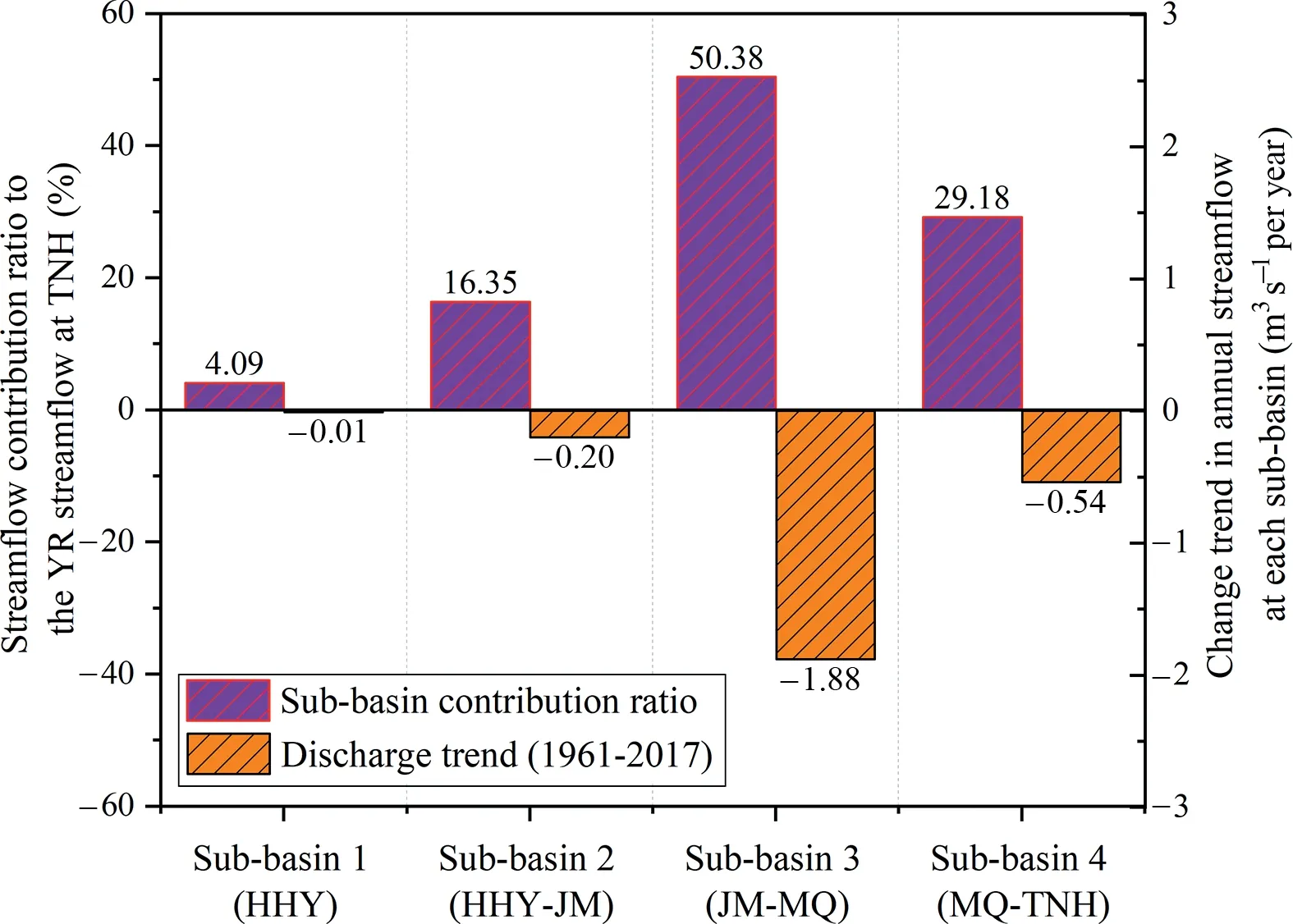
Fig. 5. Trends and contribution of the SAYR to YR streamflow in four subbasins, northeastern Qinghai-Tibet Plateau during 1961-2017.
5.3. Impacts of changing seasonal distribution in precipitation and evaporation on YR flows
It is now known that the general declining trends of streamflow in the SAYR and sub-basins are attributed to low precipitation and potent evaporation.What are the reasons for low annual precipitation and strong evaporation? Despite of a general upward trend in annual precipitation,a marked change in seasonal regimes of precipitation was observed in the SAYR during 1961-2017 (Fig. 7): increase in cold seasons (winter and spring) and decline in warm seasons (summer and autumn), especially in August and September, a sign of declining Southwest China Autumn Rain (Bai and Dong,2004). Evaporation show a significant increase in summer(Fig. 9). In comparison with Fig. 3, the general decline in annual streamflow can be attributed to decreasing streamflow in summer and autumn, probably resulting from declining Southwest China Autumn Rain and significantly enhancing evaporation in summer season.
In the SAYR, precipitation generally synchronizes with air temperature. The increasing precipitation in both the first month of spring and last month in autumn among all subbasins demonstrate a warmer and wetter climate as a result of an advanced spring and delayed autumn in the SAYR.
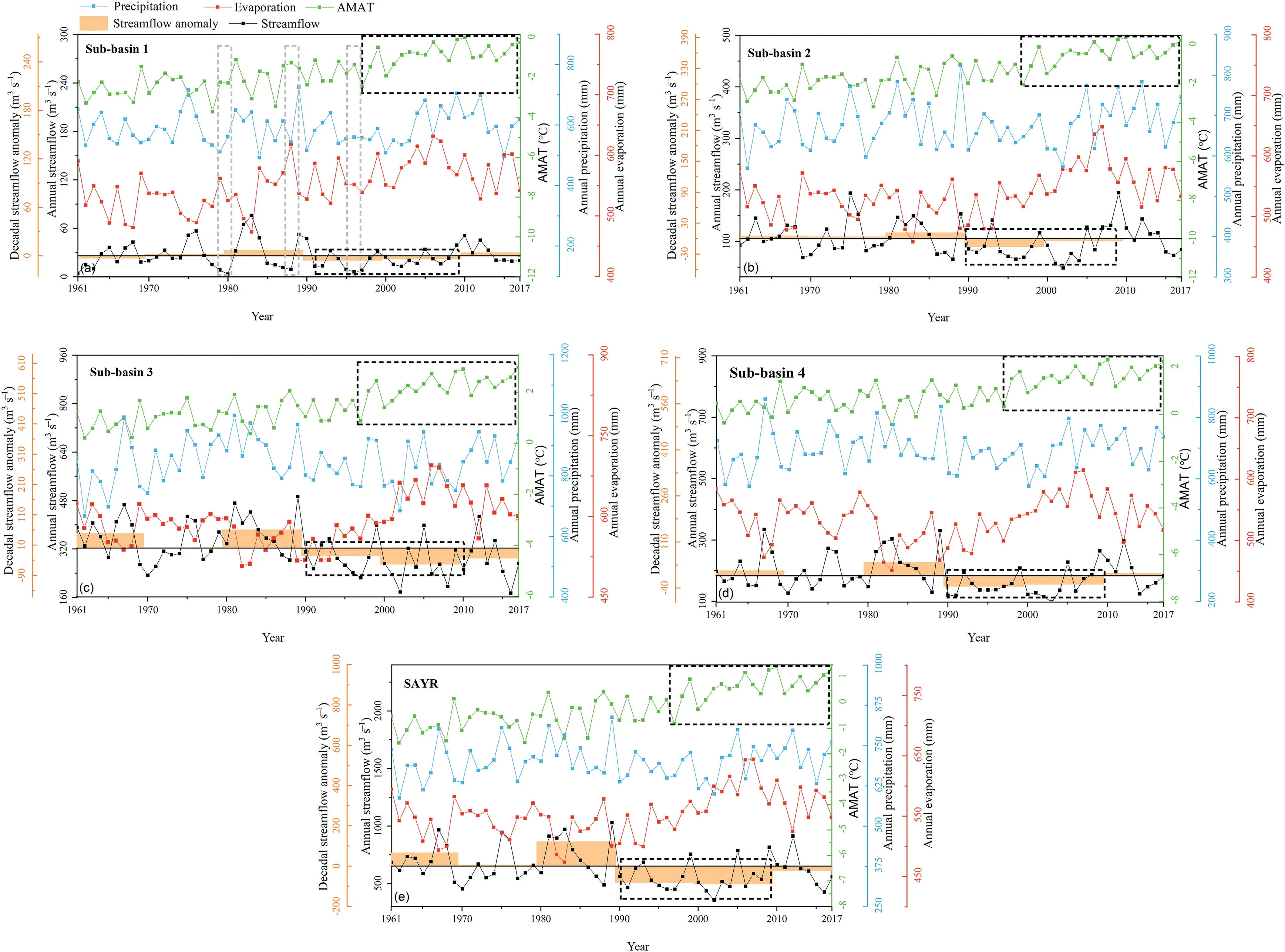
Fig.6.Changes in the streamflow,evaporation,precipitation and air temperature in the SAYR on northeastern Qinghai-Tibet Plateau(The black line is the average of 1961-2017).
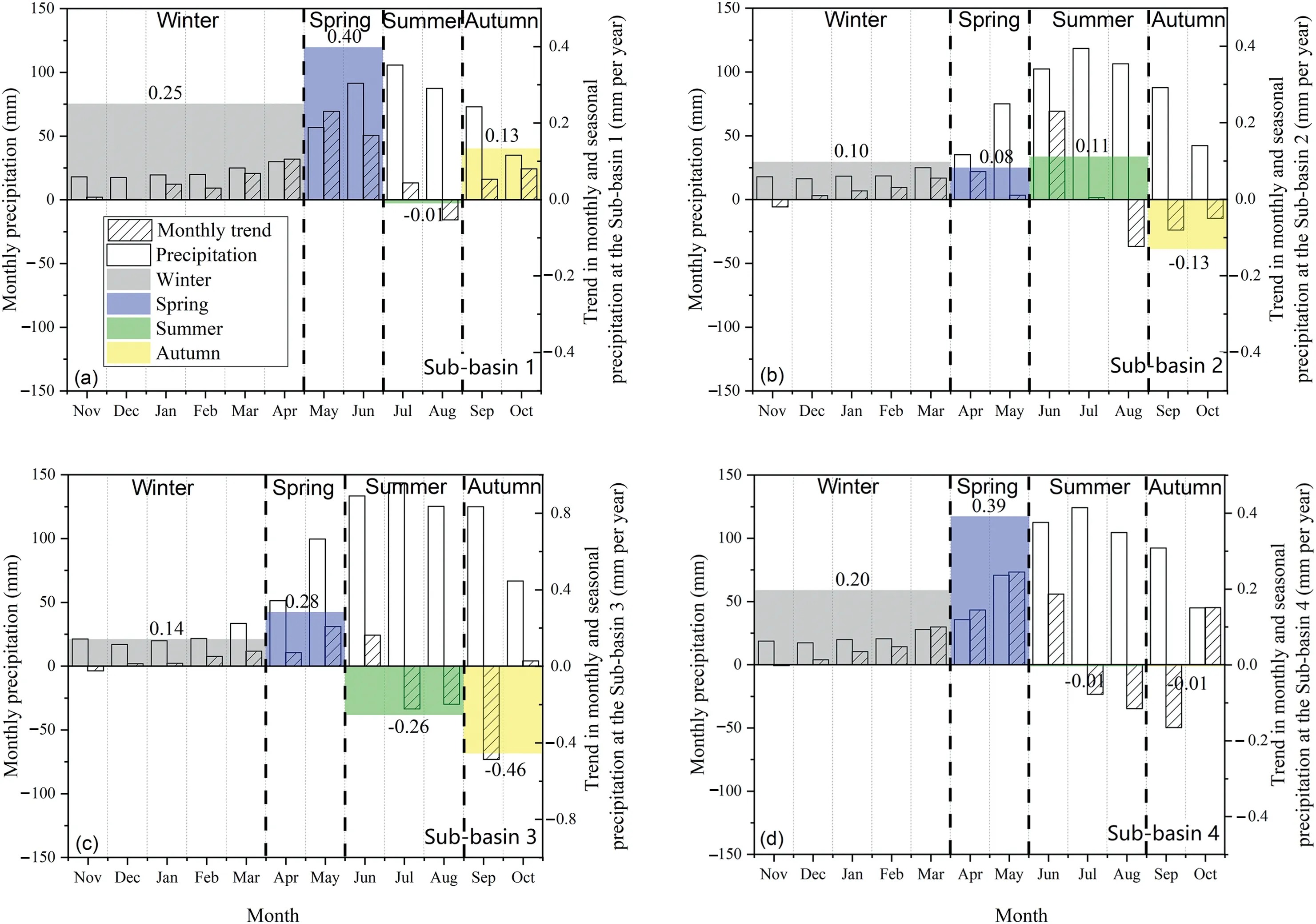
Fig. 7. Trends in monthly and seasonal precipitation in the four sub-basins in the SAYR on northeastern Qinghai-Tibet Plateau during 1961-2017.
Fig. 8. Trends in monthly and seasonal evaporation in the four sub-basins in the SAYR on northeastern Qinghai-Tibet Plateau during 196-2017.
Fig. 9. Conceptual sketch of hydrological shifts on pre-degradation (a) and post-degradation (b) permafrost slopes in the SAYR on the northeastern Qinghai-Tibet Plateau (Red droplet refers to ground-ice-melt water; Blue droplet refers to water delivered by improved hydraulic connectivity, and;Brown droplet refers to water transferred by rainfall infiltration. Droplet number does not proportionally and precisely represent the actual water quantity.).
In Sub-basin 4,slightly increasing evaporation (Fig.8)and pronounced increase in precipitation (Fig. 7) in cold season,when surface hydrological processes mostly have paused, are supposed to induce elevated spring streamflow. Unexpectedly,a decreased spring streamflow occurred (Fig. 3). Due to more dams and croplands in the Zoıˆg´e Plateau and lower reaches of the SAYR (Hu et al., 2014), the decreased spring YR streamflow in Sub-basins 3 and 4 may not only be driven by the appreciably increased evaporation, but also by anthropogenic disturbances,such as water damming for domestic usage and agricultural irrigation.
5.4. Causal analyses for changing YR streamflow
Some recent research has regarded permafrost degradation as a cause for the SAYR streamflow decrease (e.g., Li et al.,2012; Wang et al., 2018c). The impacts of degrading permafrost on the YR streamflow in the SAYR involve in: 1) icemelt recharge, 2) discharge of groundwater to pingos and seasonally frost mounds, icings, springs, wetlands and thermokarst lakes, and recharge of thermokarst lakes, and; 3)shifts in seasonal streamflow patterns and flattened hydrographs due to increased vertical infiltration of precipitation(Fig. 9). However, permafrost degradation hardly reduces the YR streamflow; rather, it may enhance the streamflow.Furthermore, the deterioration of vegetation also accelerates permafrost degradation and subsequently results in substantial hydrological impacts. The streamflow contribution ratio of permafrost degradation is 4.09% (in the Sub-basin 1 undergoing substantially hydrological shifts), and; the contribution of ice-melt to streamflow is 0.32%in the Sub-basins 2,0.12%in the Sub-basin 3, and 0.33% in the Sub-basin 4. A total of 4.9% is quantified as the impacts of degrading permafrost on the YR streamflow in the SAYR.
In August-September,the weakening of the Southwest China Autumn Rain and significantly increasing evaporation in summer are the major reasons for general downward trend of YR streamflow in the SAYR,especially in main streamflow contribution sub-basins (i.e., Sub-basins 3 and 4). Anthropogenic disturbances tend to reduce the YR streamflow in the SAYR.
5.5. Uncertainty analyses
A value of 4.09%(streamflow contribution of the HAYR to the SYAR flow at TNG), taken as a partially quantified hydrological impact of permafrost degradation in the HAYR,may be overestimated.Even though,the HAYR,with minimal anthropogenic disturbances, undergoes substantially hydrological shifts as a result of permafrost degradation.
The ice-melt water for recharging groundwater and YR streamflow among sub-basins and in the SAYR remains uncertain due to inadequate data for runoff generation and outflowing pathways, as well as the projected timespan for permafrost thaw, such as the 100 years projection under the RCP 4.5 scenario. Meanwhile, evaluation of improved hydraulic connectivity in Sub-basins 2, 3 and 4 is largely neglected due to the scarcity of relevant data. Nonetheless,4.9% is a still referable value based on current recognition of mechanisms for the hydrological impacts of permafrost degradation on the YR streamflow.
6. Conclusions and prospects
6.1. Summaries
1) Hydrological impacts on the YR streamflow from degrading permafrost in the SAYR can be divided into three major parts:
i. Ice-melt will recharge groundwater storage.The icemelt recharge accounts for 14.4% of annual streamflow in Sub-basin 1 (HAYR); 1.9% in Subbasin 2; 0.2% in Sub-basin 3; 1.1% in Sub-basin 4;and overall, an average of 1.3% over the SAYR.
ii. Improved hydraulic connections boost hydrothermal exchanges between surface waters and subpermafrost waters. Widely detected increase in winter flow in the SAYR suggests more discharge of the sub-permafrost water to surface waters.
iii. Sinkhole-sieve mechanisms of permafrost degradation on surface flows will redistribute streamflow,boost vertical infiltration,reduce lateral delivery,and alter intra-annual distribution of YR streamflow.However, sinkhole-sieve mechanism is merely detected in Sub-basin 1 (HAYR).
2) Permafrost degradation has only appreciable impacts on the YR streamflow in the SAYR (4.9%). Declined Southwest China Autumn Rain and enhanced summer evaporation may largely account for the declined SAYR streamflow. Overgrazing, damming and irrigation might have also contributed to the declined YR streamflow to certain extents. Under a warming climate, advance of spring and delay of autumn may help boost the YR streamflow in the first month in spring and last month in autumn in the SAYR as a whole.
6.2. Inadequacies
In the aspects of data availability hydrometeorological and geocryological data are still inadequate to fully substantiate the impacts of permafrost degradation on changes in the YR streamflow. Subsurface geological structures and vertical and lateral extents and ice content of permafrost, as well as hydrothermal parameters of varied soil types in frozen/unfrozen conditions, are insufficiently investigated in the SAYR. These result in difficulties in modeling dynamics of permafrost changes, ground-ice melt-water recharge to groundwater, and subsurface hydrological processes in the environment of degrading permafrost under a warming climate.Monitoring of changes in hydrothermally-influenced landscapes, soil icecontent in the active layer and implement of isotope tracing techniques are still inadequate in the SAYR. Long-term hydrometeorological observations, change in thermallyinfluenced landscapes, vertical and lateral permafrost extent,ice-content and subsurface geological structures are key to bolstering the pertinent understanding and how the streamflow would change under a warming climate in the future.
6.3. Prospects
Multi-scale and multi-method approaches are required to study the impacts of permafrost degradation on the SAYR streamflow. Remote sensing techniques/unmanned aerial vehicles in combination with geophysical methods can be employed to feature vertical and lateral extent of permafrost and ice-content of permafrost and subsurface geological structures. Field investigations for surface waters and landscape types, in-situ hydrothermal dynamics and borehole observations and sampling, should be incorporated. Laboratory analyses of hydrothermal parameters and other soil properties associated with freeze/thaw cycles, especially for varied saturation conditions, are also important. Long-term hydrometeorological observations and chemical/isotopic tracing techniques integrating numerical simulations can better constrain the hydrological impacts of permafrost degradation in the SAYR. Among the above-mentioned methods, remote sensing techniques for basin-scale spontaneous observations and isotope-tracing techniques should be prioritized.
Conflict of interest
The authors declare no conflict of interest.
Acknowledgments
This work was supported by the Chinese Academy of Sciences Strategic Priority Research Program(XDA20100103), Ministry of Science and Technology of China Key R&D Program (2017YFC0405704), and CAS Overseas Professorships of Victor F Bense and Sergey S Marchenko at the former Cold and Arid Regions Environmental and Engineering Research Institute (now renamed to Northwest Institute of Eco-Environment and Resources),CAS during 2013-2016.
杂志排行

Advances in Climate Change Research的其它文章
- Sensitivity of the simulated CO2 concentration to inter-annual variations of its sources and sinks over East Asia
- China's long-term low carbon transition pathway under the urbanization process
- Impact of environmental change on runoff in a transitional basin:Tao River Basin from the Tibetan Plateau to the Loess Plateau, China
- Regional differences in global glacier retreat from 1980 to 2015
- Assessments of the Arctic amplification and the changes in the Arctic sea surface