Satellite group autonomous operation mechanism and planning algorithm for marine target surveillance
2019-04-28ChaoZHANGJinyongCHENYaninLIYuqingLIWeijieCHAI
Chao ZHANG , Jinyong CHEN , Yanin LI, Yuqing LI, Weijie CHAI
a CETC Key Laboratory of Aerospace Information Applications, Shijiazhuang 050081, China
b Deep Space Exploration Research Center, Harbin Institute of Technology, Harbin 150080, China
c The 54th Research Institute of China Electronics Technology Group Corporation, Shijiazhuang 050081, China
KEYWORDS Fast response;Marine target surveillance;Mission planning;Multi-satellite system;Onboard autonomy
Abstract In terms of fast response problem of unanticipated marine target,it is necessary to design the satellite-ground-combined operation mechanism and planning algorithm for autonomous task planning.Firstly,based on the autonomous operation and task planning of remote sensing satellite group, it is divided into two parts: ground planning and satellite autonomous planning. Secondly,the satellite-ground-combined operation mechanism and operation flow for task planning are proposed after fully considering the resource characteristics and task demand characteristics of the ground and satellite.The satellite autonomous task planning algorithm based on extended contract net is designed. Through the simulation operation of the self-developed distributed simulation demonstration software,it shows that the operation mechanism can coordinate and cooperate effectively between the satellite autonomous task planning and ground planning.It can give full play to the advantages of the ground computing resources,ref lect the control intention,make full use of the real-time feature and flexibility of the satellite calculation, and respond fast to the unanticipated task. Besides, it has solved problems of the untimely response of ground control on unanticipated observation task, the limitation of satellite computing resources and satellite-ground planning and coordination, which can effectively improve the responsiveness of remote sensing satellite to the observation task of maritime unanticipated target.
1. Introduction
Maritime moving target is usually the low-speed moving target within a larger area in the marine environment, which mainly refers to surface ship or ship formation. The reconnaissance effect is not very satisfactory due to the limited visual range and activity scope when the moving target is reconnoitered through land-based, sea-based or sky reconnaissance equipment, especially for maritime moving target.
However,it is difficult to realize real-time ground measurement and control support for remote sensing satellite due to satellite orbit characteristics and the restrictions regarding the construction of the ground station. Especially when the satellite is outside the country, the available ground measurement and control conditions are very limited. Meanwhile,there are many sensitive target observation tasks in the overseas maritime non-measurement-control area.Inevitably,there are unanticipated cases such as emergence of the target,disappearance of the target, failed observation arising from execution failure and so on.
In order to enhance the fast response ability of remote sensing satellite on the maritime moving target surveillance, and deal with various abnormal situations, the remote sensing satellite should have the capability of autonomous task planning and can realize the collaborative observation of multiple satellites,so as to give full play to the characteristics and capabilities of different loads. With the increasing requirement of intelligence and ref inement of satellite operation, the demand for autonomous task planning ability of remote sensing satellite is becoming increasingly prominent.1-3
According to the above requirements, Chinese and foreign scholars carried out researches in different backgrounds.4-6For example, Ref.7proposed a dynamic planning algorithm,which can be used for autonomous task planning of in-orbit satellite. Ref.8conducted in-depth study on autonomous task planning, and designed and implemented the autonomous planning system of the EO-1 satellite. Refs.9,10presented an onboard autonomous mission re-planning system for Multi-Satellite System (MSS) to perform onboard re-planing in disruptive situations. Refs.11,12conducted a relatively extensive study on the planning and scheduling algorithm of electromagnetic remote sensing satellite. Ref.13conducted systematic analysis and formal description of the joint scheduling of the sky-based marine moving target surveillance and established a general model of joint scheduling. Ref.14studied the EOS real-time dynamic planning, built a multi-objective optimization model after comprehensively considering the balanced use of load, energy and storage, and then designed a dynamic real-time planning algorithm, thus solving the uncertainty of the task arrival.
It can be seen from the analysis of current research results that most researches are conducted on the solution method or architecture,15-17but few focus on the design of autonomous operation mechanism and process. In fact, for autonomous collaborative marine target surveillance of remote sensing satellite group,as basic technical issues,independent operation mechanism and process play an important role in the overall operation effect of the system with signif icant influence.
The design of satellite-ground-combined operation mechanism for autonomous planning aims to address fast response and observation surveillance of marine unanticipated target,especially in the absence of ground measurement and control support.It should be pointed out that the autonomous operation of the remote sensing satellite group should not be completely dependent on the satellite calculation because (A) it is vital to choose between calculation time and optimization ability due to the limited satellite calculation capability; (B) the complete autonomous observation can hardly ref lect certain specific human intention. Therefore, effective coordination and cooperation mechanism should be designed between the satellite autonomous task planning and ground planning, so that the whole system can not only give full play to the advantages of the ground computing resources,ref lecting the control intention, but also make full use of the real-time feature and flexibility of the satellite calculation, responding fast to the unanticipated task.
Based on the above def iciencies, the present paper studies the autonomous task planning of remote sensing satellite group, designs an autonomous operation mechanism, including ground static and dynamic planning and satellite autonomous planning, and designs its operation flow and planning algorithm in detail.
2. Overview of maritime target tracking and surveillance of remote sensing satellite
Moving target search is complicated due to complexity of marine environment, uncertainty of target movement, high timeliness of task and incompleteness of reconnaissance equipment.The imaging reconnaissance satellite should be used in conjunction with electronic reconnaissance and ocean surveillance satellites (see Fig. 1).
Although the introduction of satellite in-orbit autonomous task planning can improve the emergency response capability of the unanticipated task for marine target surveillance,ground task planning is still signif icant.This is mainly because the ground has more perfect computing resources, which is conducive to more eff icient and reasonable optimization of observation task. There is also human intention factor that cannot be neglected, so it is not appropriate to abandon all ground task planning.Therefore,the more reasonable autonomous operation mechanism should have two parts: satellite autonomous task planning and ground task planning.
In this paper, considering the actual situation of satellite operation and autonomous operation demand, according to two functions: satellite normal operation management and the response of unanticipated target management,the problem is decomposed into the following sub-problems (Fig. 2)
(1) Ground centralized multi-satellite static collaborative task planning for long-term management.
(2) Ground centralized multi-satellite dynamic collaborative task planning for unanticipated target.
(3) Multi-satellite autonomous dynamic collaborative task planning for fast response of unanticipated target.
For the first two items, the advantages of ground calculation capability can be given full play to and intelligent optimization algorithm can be used to solve them. In terms of the third item, the task planning method based on heuristic search and distributed optimization is adopted to get it solved according to satellite calculation allocation situation.
3. Multi-satellite autonomous satellite-ground-combined operation mechanism
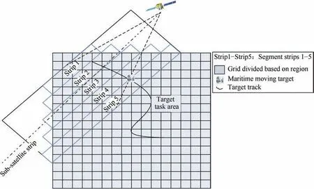
Fig. 1 Schematic diagram of maritime target tracking and surveillance of satellite.
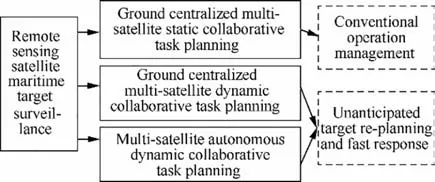
Fig. 2 Satellite group observation autonomous task planning problem decomposition.
Considering autonomous operation ability of remote sensing satellite, in order to support task coordination among various satellites, assuming that the inter-satellite communication link exists among these satellites, a distributed on-ground observation system is formed, as shown in Fig. 3.
Under the framework of the above system structure, the autonomous operation mechanism and process of the satellite group are preliminarily designed, as shown in Figs. 4 and 5.
In the initial stage,an initial task plan is generated for each satellite through a unif ied ground centralized planning. After the task is implemented, the satellites perform the observation task according to the established plan in normal situation.When there is an unforeseen circumstance, after the unanticipated observation request is produced, firstly, it is judged whether the ground communication support can be obtained:(A) If there is an available satellite-ground link, the ground will carry out dynamic collaborative task planning of the satellite group (that is, re-planning); (B) Or distributed autonomous dynamic collaborative task planning is carried out by these satellites. The specific operation process is as follows:
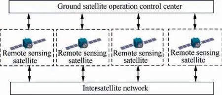
Fig. 3 Schematic diagram of system structure of multi-satellite collaborative task planning.
Step 1.The starting time of the initial planning interval is tstart,the end time is tend,the length of the planning interval is Thorizon,and the initial observation task planning starts at tstart-TprePla. Convey the execution instruction before tstart.Step 2.Judge if there is an unanticipated observation task in the execution process. If there is, turn to Step 5, otherwise continue the execution.
Step 3.Judge if it is time to start the next task planning time tend-TprePla.If it is,turn to Step 4 to start the task planning of the next planning interval; if not, turn to Step 2 to continue.
Step 4.Start the ground centralized satellite group static collaborative task planning, carry out the task planning of the next planning interval, convey the execution instruction, and turn to Step 2.
Step 5.Judge whether it can communicate with the ground.If so, turn to Step 6 to carry out the ground centralized satellite group dynamic collaborative task planning; if not, turn to Step 7 to carry out the satellite group autonomous dynamic collaborative task planning.
Step 6.The starting time of the initial planning interval is tre-start, the end time is ta-end, the length of the planning interval is Ta-horizon, and the ground centralized satellite group dynamic collaborative task planning starts at tre-start-TgetReady. Convey the execution instruction before tre-start, and turn to Step 2.
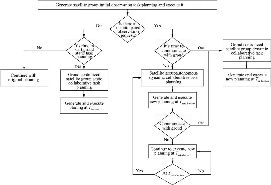
Fig. 4 Autonomous operation mechanism and process of satellite group.
Step 8.Determine whether it can communicate with the ground during the implementation of autonomous task planning. If so, turn to Step 6, otherwise continue the implementation of autonomous task planning.
Step 9.Determine whether it is at ta-end.If so,turn to Step 7 to carry on satellite group autonomous dynamic collaborative task planning at next Ta-horizon,otherwise turn to Step 8.
Among them,TprePlais the preparation time for ground static task planning,including the process of negotiation,calculation,instruction conveying,etc.TgetReadyis the preparation time for ground dynamic task planning. Ta-horizonis the planning time interval for the satellite group autonomous task planning,which is determined according to the orbital characteristics of satellite group and the distribution of the ground measurement and control resources. The communication should be established with the ground in the interval and the ground should have enough time to produce new task planning conveying.
Under extreme conditions, within Ta-horizon:
(1) The satellite group do not communicate with the ground.
They thrust their spears into the terrible snow-flakes, so that they shivered into a hundred pieces, and little Gerda could go forward with courage and safety
(2) The ground does not complete the new planning conveying.
(3) It is not time for new planning execution.
In the above case, there will be a gap between the end time ta-endof the autonomous planning execution and the start time tre-startof executing ground re-planning, as shown in Case (c), Fig. 6. In regard of such condition, it is known from Step 7 to Step 9 that the satellite group will initiate a new round of autonomous task planning and execute it until the new ground planning is obtained and implemented, as shown in Fig. 6.
4. Satellite autonomous task planning algorithm based on extended contract net
Multi-agent algorithm is widely used in spacecraft task scheduling.18,19The basic framework of satellite autonomous task planning algorithm based on extended contract net is shown in Fig.7,including two levels.The first level is the allocation of external market opportunity task between Agents.At this level,multiple Agents participate in the external task allocation competition. It can be assumed that only an Agent can obtain such an external market opportunity task and acquire task information through external interface of the system or environment agent. Once an Agent that gets the task requires assistance from other Agents, it enters the second level of task allocation. At the second level, the Agent requiring assistance is the allocator of the task, and automatically becomes the manager in the contract net, bidding to other Agents. The Agent that gets the task information can become the recipient of the task and automatically become the contractor in the contract net. Besides, multiple Agents are allowed to win the bid simultaneously (see Figs. 8 and 9).
The principal satellite picks out the top subtasks from the subtask set. For selected subtasks, the principal satellite sends bidding information to each subordinate satellite,which can be represented by a seven-element array as follows:
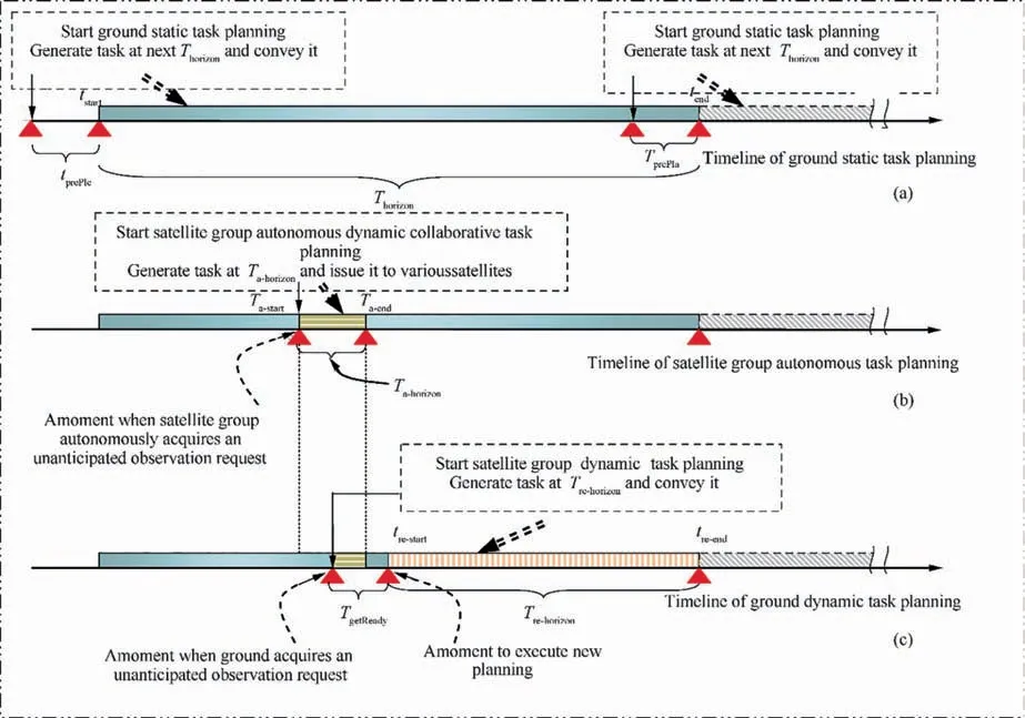
Fig. 5 Schematic diagram of operation process timeline of satellite group autonomous task planning.
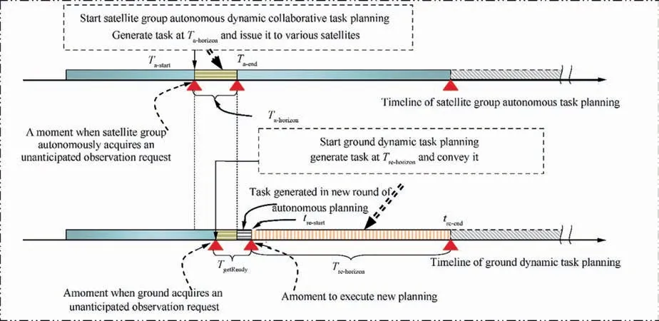
Fig. 6 Schematic diagram of timeline of continuous autonomous planning and ground re-planning coordination.

where r is unexpected subtask number; Latituderis target latitude; Longituderis target longitude; TaskLETris the latest start time of subtask tr; Task Durationris subtask duration;PRris subtask priority; Task Typeris subtask type.
After receiving the bidding information, each subordinate satellite conducts subtask constraint checking. The subordinate satellite passing task constraint checking sends tendering information to the principal satellite,which can be represented by an eight-element array as follows:
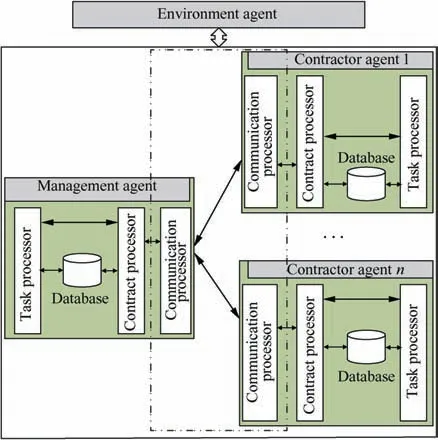
Fig. 7 Task allocation framework based on extended contract network.

where m is satellite number; qmis satellite payload type;Task Typeris subtask type; TaskSTrmis the start time of the satellite Smexecuting subtask tr; Task ETrmis the end time of the satellite Smexecuting subtask tr;Costrmis the cost of satellite Smcompleting subtask tr; Profitrmis the prof it of satellite Smcompleting subtask tr.
After receiving the bidding information from subordinate satellites, principal satellite calculates and compares the net income of completed tasks from subordinate satellites according to Eq.(1),which is the difference between income and cost.Subtask allocation is carried out according to the principle of maximum net income. The competitive subordinate satellite with the largest net income will win the bid.

where Viis observing target gains; xiis the target selected for observation, and if selected, xi=1, otherwise xi=0; eiis battery energy consumed by this target observation task.
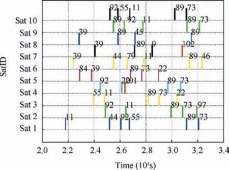
Fig. 9 Results of satellite autonomous-operation unanticipated task planning.
5. Simulation example analysis
The number of satellites is set as 10 in simulation scene. Their orbit is based on the orbital parameters of Orbview, Landsat,ZY-3,FY-1,Mapping Satellite-1,etc.to accomplish the target observation together. The orbital parameters of each satellite are shown in Table 1.
Considering the load of visible light,infrared and Synthetic Aperture Radar (SAR), 100 targets were randomly selected worldwide. The initial task planning of each satellite was obtained through ground centralized task planning with the use of genetic algorithm. A marine target was randomly chosen as a target for unanticipated case, located at (87.9702,122.0291). Autonomous task planning interval Ta-horizon=180 min. The paper adopts a method of adding a reasonable random amount to latitude and longitude of the non-expected target position to simulate dynamic movement and trajectory changes of the target.The major star issues tender information as shown in Table 2.
From the above f igure, we can see that there is at least one visible time window for each of the satellite-to-subtask 1 and 2 targets in a planning period (180 min). After the task constraints, time constraints, and energy constraint checks, satellite Sat 4 and Sat 5 bid for subtask 1, satellite Sat 7 bids for subtask 2,and the rest of the satellites abandon the bid.Table 2 shows the time to perform subtasks and the benef its of completing the tasks. Judgment is tested.
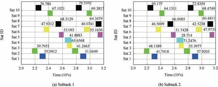
Fig. 8 Candidate visible time window of each satellite for subtasks.
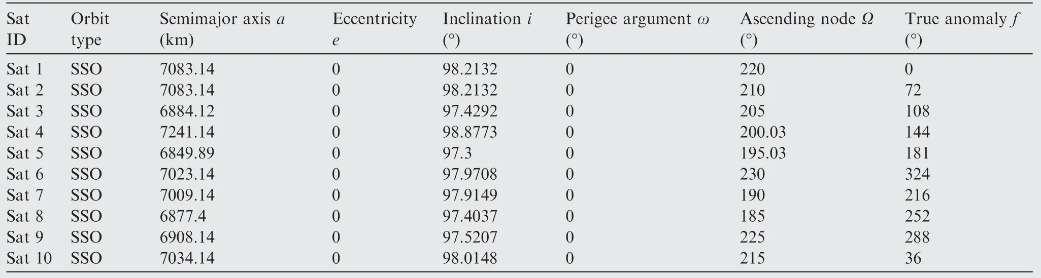
Table 1 Satellite orbital parameters.
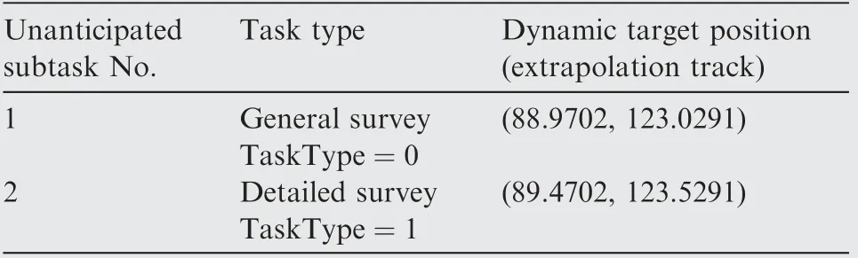
Table 2 Subtask tendering information.
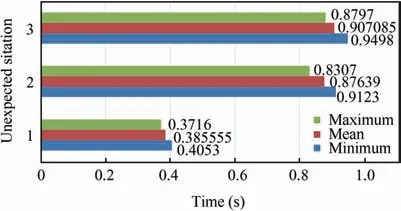
Fig. 10 Program running time.
In the above f igure,the x-coordinate is the time axis and the y-coordinate represents the satellite number. Each rectangular color block expresses a task,where the red rectangle represents the unanticipated subtask 1 and 2,and the remaining rectangle blocks are the task sequence for the initial planning.Thus,the complete satellite autonomous task planning process is over here.
For each of the three different unforeseen circumstances,20 independent mission planning simulations were performed for each unexpected situation.The statistical results of the calculation time are shown in Fig. 10, where green indicates the minimum value,red indicates the average value,and blue indicates the maximum value.
6. Conclusions
(1) Through the analysis on the above simulation results, it can be concluded that the satellite-ground-combined operation mechanism proposed in this paper can well handle the fast response of unanticipated observation requests for marine target. And it can respond to unanticipated new tasks in a timely manner provided that the original task is normally carried out, so as to verify the rationality of combined operation mechanism and flow.
(2) The satellite autonomous task planning algorithm based on extended contract net considers the task planning negotiation mechanism between the principal satellite(manager) and subordinate satellite (worker) in the case of unanticipated marine target in dynamic and complex observation environment. The algorithm is a rule-based algorithm, which fully considers the characteristics of weak computing capability of the satellite. Its effectiveness is also verif ied by a simulation example in this paper.
Acknowledgements
This study was co-supported by the Open Fund of CETC Key Laboratory of Aerospace Information Applications of China(No. EX166290023) and the Open Fund of National Defense Key Disciplines Laboratory of Deep Space Exploration Landing and Return Control Technology of China (No. HIT.KLOF.2016.077).
杂志排行

CHINESE JOURNAL OF AERONAUTICS的其它文章
- Guide for Authors
- CHINESE JOURNAL OF AERONAUTICS
- An automated approach to calculating the maximum diameters of multiple cutters and their paths for sectional milling of centrifugal impellers on a 4½-axis CNC machine
- Residual stresses of polycrystalline CBN abrasive grits brazed with a high-frequency induction heating technique
- Online scheduling of image satellites based on neural networks and deep reinforcement learning
- An evolutionary computational framework for capacity-safety trade-oあin an air transportation network