Vegetation and climate history of Anggertu Lake in the Tengger Desert over the last millennium*
2018-12-22DUANFutao段阜涛ANChengbang安成邦ZHAOYongtao赵永涛WANGWei王伟CAOZhihong曹志宏ZHOUAifeng周爱峰
DUAN Futao (段阜涛), AN Chengbang (安成邦) , ZHAO Yongtao (赵永涛),WANG Wei (王伟), CAO Zhihong (曹志宏), ZHOU Aifeng (周爱峰)
College of Earth Environmental Sciences, MOE Key Laboratory of Western China’s Environmental Systems, Lanzhou University,Lanzhou 730000, China
Abstract Reconstructing climate change of the last millennium is important to understand the current relationship between human-social activities and natural environmental changes. Pollen assemblages, losson-ignition (LOI org at 550°C), and grain size data collected from sediment core AGE15A from the center of Anggertu lake (eastern Tengger Desert, Inner Mongolia) were used to reconstruct the regional vegetation and climate history of the last millennium. Desert or steppe desert, dominated by Artemisia and Amaranthaceae,expanded around this region during the period of 988–1437 AD indicating a generally dry climate condition with two short humid periods (1003–1082 AD and 1388–1437 AD). These two wet periods were characterized by relatively high vegetation cover and bioproductivity, as reflected by high pollen concentrations and LOI org values. Increases in steppe and meadow vegetation communities (Poaceae, Cyperaceae) and vegetation cover during 1437–2015 AD suggest a wetting trend, which was also deduced from a gradual trend towards fine grains and higher lake biological productivity as reflected by LOI org values. An unstable lacustrine environment was identified via frequent fluctuations in pollen concentration and grain size after 1842 AD.This study also recorded a relatively dry Medieval Warm Period (MWP, 1082–1388 AD) and a wet Little Ice Age (LIA, 1437–1842 AD). Increased Amaranthaceae and high abundance of Poaceae may be related to overgrazing and agricultural activities that took place during those time periods. The evolution of vegetation in the lake region was influenced by climate change and human activities. These results could provide more fundamental support for studies of the environmental evolution of the Tengger Desert.
Keyword: Anggertu Lake; Tengger Desert; lacustrine record; vegetation; climate changes; the last millennium
1 INTRODUCTION
Studying the last millennium of climate change can help us to understand the current relationship between human-social activities and natural environmental changes. In particular, the Medieval Warm Period (MWP) and Little Ice Age (LIA) are abrupt climatic events with global signatures during the last millennium (Mann et al., 2009). There are distinct temperature discrepancies between these two intervals (PAGES 2k Consortium, 2013), and they significantly influenced on human civilization and dynastic changes over the last millennium (Zhang et al., 2008a; Kennett et al., 2012). However, moisture conditions at various locations during these two climatic events remain controversial and require further study. Numerous recent studies have reconstructed the climate changes of the last millennium in different regions in China based on multi-proxy (e.g., tree-rings, ice cores, lake sediments, and historical documents) approaches.For example, reconstruction of climate changes on the northeastern Tibetan Plateau from various types of paleoclimatic archives (Yao et al., 1991; Mosley-Thompson et al., 1993; Zhang et al., 2004b; Yang et al., 2014; Gou et al., 2015a, b) indicates that regional precipitation changes were typically positively correlated with temperature changes. This is consistent with information from historical documents (Tan et al., 2008). Specifically, the MWP was characterized by high precipitation in most areas of monsoonal northern China (Jin et al., 2002; Liu et al., 2011; Tan et al., 2011; Chen et al., 2015; Tian et al., 2017). This was accompanied by increases in lake levels (Jin et al., 2002), vegetation density (Ren,1998), and bio-productivity (Jin et al., 2002). The LIA was dominated by cold-dry climate, with lake shrinkage (Xiao et al., 2008), vegetation deterioration(Meng et al., 2009) and slowing of watershed chemical weathering (Jin et al., 2001; Liu et al.,2014). Speleothems suggest that the Asian summer monsoon intensified during the MWP (Hu et al.,2008; Zhang et al., 2008a). It is thought that this is the main cause of subsequent elevated precipitation.However, recent publications have found that temperature and precipitation/moisture are typically negatively correlated on the centennial timescale in arid central Asia (ACA) (Yang et al., 2009; Chen et al., 2010). For example, a 1 000-year high-resolution chironomid record from Sugan Lake suggested that high salinity and hence a drier climate occurred in this area during the MWP, and that the inverse occured during the LIA (Chen et al., 2009). High LIA precipitation and accumulation rates were recorded in the Guliya ice cap (Thompson et al., 1995; Yao et al., 1996; Yang et al., 2009). Moreover, Chen et al.(2015) further revealed that ACA and monsoonal southern China were generally drier, while monsoonal northern China was generally wetter during the Medieval Climate Anomaly (MCA, 1000–1300 AD)than during the LIA. In conclusion, there is no consensus regarding the climate change characteristics in different regions over the last millennium.
The Tengger Desert (Inner Mongolia, northwestern China) is situated at the transitional zone between the monsoon and the westerlies and is an important geographical unit primarily covered by mobile sand dunes. Vegetation communities and ecosystems in the area are sensitive to climate changes (Zhu et al.,1980). At the same time, the area is located in the ecotone between agriculture and nomadic culture,which is vulnerable to human activities. Therefore, it is an ideal location for a study of both regional environmental changes and human activities. Previous works have investigated the palaeoenvironmental history of the Tengger Desert at millennial and orbital scales, with most evidence coming from the evolution of the paleolakes (Pachur et al., 1995; Zhang et al.,2002, 2004c), desert (Guan et al., 2011; Li et al.,2014), and paleovegetation and paleoclimate conditions (Ma et al., 1998, 2004; Madsen et al.,2003; Chen et al., 2003; Zhao et al., 2008a; Qiang et al., 2010). However, due to the lack of continuous,effectively dated records of the dryland, some studies may not have presented real palaeoenvironment conditions in a comprehensive manner (Yang et al.,2011). Despite the numerous studies, centennial-scale climate and vegetation changes in the Tengger Desert during the last millennium are far from fully understood. In this study, a sediment core (AGE15A)drilled from Anggertu Lake in the eastern margin of the Tengger Desert, was used to reconstruct local vegetation and climate history over the last millennium based on pollen, organic loss-on-ignition (LOIorg),and grain size information, in the aim of providing a local environmental research with more fundamental materials to contribute to paleoclimate map reconstruction in Tengger Desert and monsoon/westerlies transition zones.
2 MATERIAL AND METHOD
2.1 Regional setting
Anggertu Lake, a freshwater lake, is located in the eastern margin of the Tengger Desert in northwestern China. The region is bordered by the Eastern Qilian Mountains to the southwest, the Hexi Corridor to the west, and the Yabulai Mountain to the northwest. The Shiyang River separates the Badain Jaran and Tengger Deserts. The Henlan Mountain, an obstacle for the East Asian Monsoon, is located to the east. To the south, desert extends to the Loess Plateau (Fig.1a).Anggertu Lake covers approximately 0.09 km2and contains significant quantities ofPhragmitesaustralis.There is a lake-freeze period in the winter, and the ice thickness can reach 20 cm. Many residual lakes in the Tengger Desert developed during the Tertiary period,and they were derived primarily from atmospheric precipitation and spring water (Wu, 2009). Recent studies have shown that lakes are likely to be supplied by atmospheric precipitation or near-source groundwater in the Tengger Desert (Lai et al., 2012).Neighboring Toudaohu Lake (38°25′N; 105°7′E) is also recharged by local precipitation (Chen et al.,2003). In addition, field investigations have found many springs around the study area. Therefore, it can be inferred that the Anggertu Lake is supplied by near-source groundwater, spring water, and atmospheric precipitation.
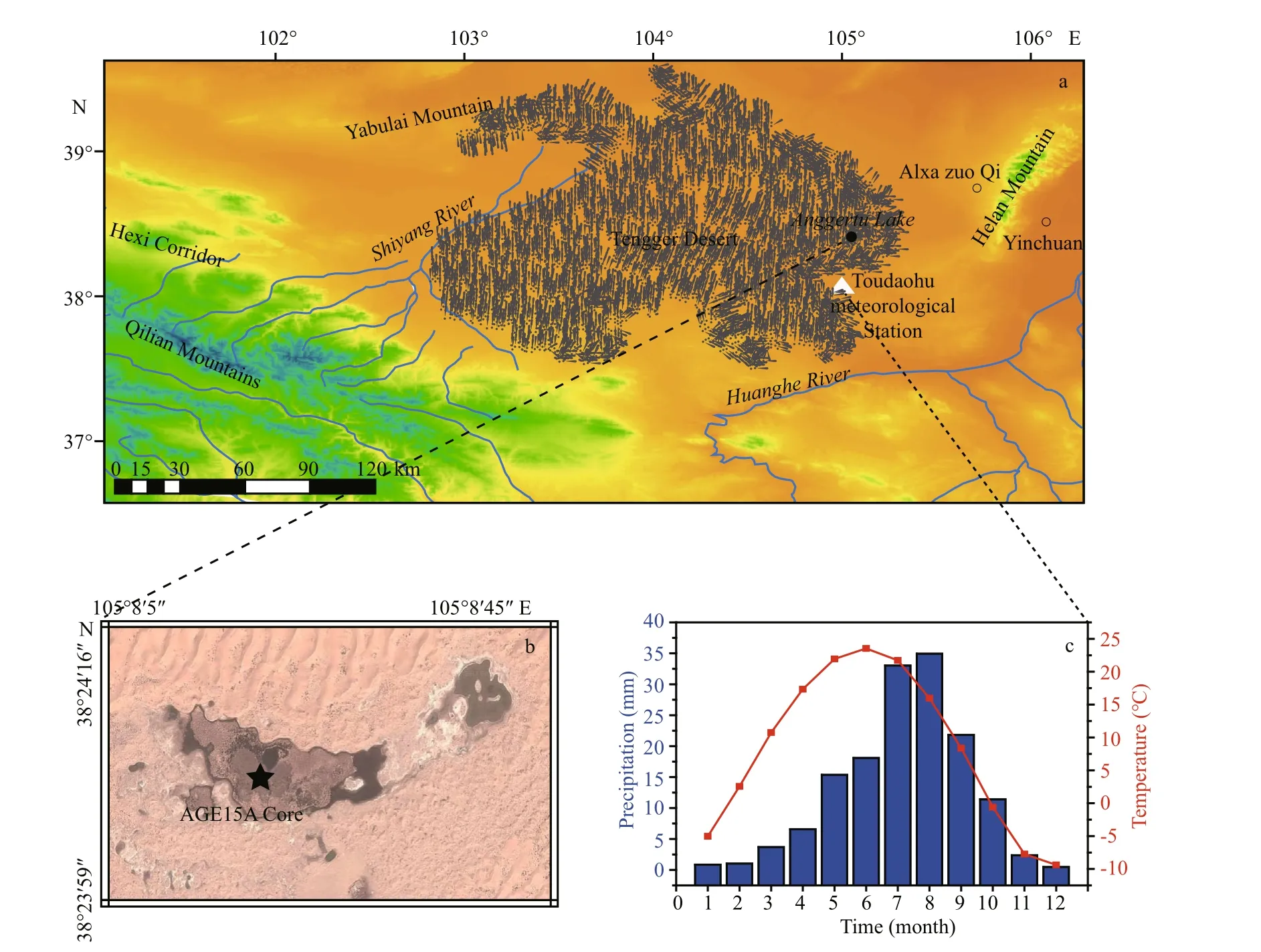
Fig.1 Study area
The regional climate is influenced by the East Asian monsoon and the westerly circulation (Zhang et al., 2004c). Instrument data (1962–2012) from the neighbouring Toudaohu meteorological station(Fig.1a) reveals that the regional mean monthly temperature are -9.4°C in December and 23.5°C in June, with mean annual precipitation of 150 mm and high potential evaporation of 3 200 mm (Fig.1c).Rainfall occurs between June and September.Therefore, the study area is dominated by a dry,temperate continental climate (Luo and Sun, 2005).
A field survey found that there is low-cover single vegetation type around the lake. Xerophytic shrubs includingCalligonummongolicumTurcz,Hedysarum mongolicumTurcz,Nitrariatangutorum, andArtemisiasieversianaconstitute the main desert vegetation components (Kong and Shen, 2003; Luo and Sun, 2005). Large amounts ofPhragmites australisgrow in the lake and small amounts ofUlmusandPopulusare distributed around it. Fixed, semifixed, and mobile dunes are present. The local abundant sandy soil with lower organic matter content is not conducive to plant growth. This leads to low vegetation coverage in the region (Luo and Sun,2005).
2.2 Core recovery and dating
A 166-cm sediment core (AGE15A) (38°24′5.89″N;105°8′5.66″E; 1 321 m a.s.l) was collected from the center of Anggertu Lake in January of 2015 using a Kullenberg Uwitech Coring System (Fig.1b). The cylindrical sediment core was split lengthwise and the flat core surface was scanned for elemental composition using an Avaatech X-ray fluorescence(XRF) core scanner at the Key Laboratory of Western China's Environmental Systems (Ministry of Education), Lanzhou University. Prior to laboratory analysis, the core was sub-sampled at 1 cm intervals,and the samples were freeze-dried and placed in cold storage. We studied vegetation and climate changes since 988 AD based on the analyses of pollen, grain size and LOI results. The chronology of core AGE15A was established based on three accelerator mass spectrometry (AMS) radiocarbon dates (two bulk materials and one plant material) measured by Beta Analytic Inc., USA.
2.3 Grain size, LOI org, and pollen analyses
A total of 166 samples were measured for grain size analysis at 1cm intervals using a Malvern Co.Ltd. Mastersizer 2000 laser diffraction particle-size analyzer. Samples were pretreated with 10% H2O2and 10% HCl to remove organic matter and dissolvable salts. The remaining material was generally within the size range of terrestrial debris described by Peng et al. (2005). The material was dispersed via sonication prior to formal measurement. The error in the average grain size was less than 2%. Grain size is often used as an important substitutable indicator of paleoenvironment in sedimentology (Håkanson and Jansson, 1983). Previous studies have shown that the grain size can reflect the winter monsoon intensity.Coarser grains indicate stronger winter monsoons,which can provide cold, dry airflows (Xiao et al.,1997; Hu et al., 2001).
Loss-on-ignition analysis was performed to measured organic contents of 166 samples. The samples were analyzed at 1 cm intervals using a muffle furnace at 550°C and standard methods(Bengtsson and Enell, 1986). The LOIorgcorrelates well with the total organic carbon (TOC) in lake sediment (Håkanson and Jansson, 1983; Cato, 1997;Zhang et al., 1998a; Brauer et al., 2000). LOIorgis typically dominated by regional climate factors such as effiective precipitation and temperature. Thus it can be used to estimate TOC and bio-productivity, as well as to reconstruct climate changes in the lake region (Brauer et al., 2000; Liu et al., 2006). Some studies have shown that humidity improved the biological productivity of the lake, leading to high sediment LOIorgvalues (Lerman, 1978; Håkanson and Jansson, 1983; Xue et al., 1994; Zhang et al., 1998a,Zhang et al., 2008b).
Eighty-three samples were selected for pollen analysis at -2 cm intervals. The samples were processed using the standard procedures described by Fægri and Iversen (1989). OneLycopodium-spore tablet (1–133 cm: 9 666; 135–165 cm: 19 332) was added before the chemical treatment to calculate pollen concentrations. Pollen identification was performed using pollen atlases of the arid and semiarid areas of China (e.g. Xi and Ning, 1994; Wang et al., 1995). All of the palynomorphs were counted under a Nikon light microscope at 400× magnification.At least 300 grains of terrestrial plant pollen from each sample were counted and used as the pollen sum for pollen percentage calculations. A/C ratios were calculated byArtemisia/Chenopodiaceae pollen percentages, which can be used to indicate the changes in the relative dominance of desert and steppe plants and effective moisture in arid and semi-arid regions of the world (EI-Moslimany, 1990; Li and Yan, 1990;Yan, 1991; Tarasov et al., 1997; Cour et al., 1999;Cohen et al., 2000; Davis and Fall, 2001; Li et al.,2005; Herzschuh, 2007; Zhao et al, 2007, 2008a,b;Gunin et al., 2011). Pollen diagrams were generated using Tilia v2.02 (Grimm, 2004). Pollen percentages were divided into various zones and subzones using the stratigraphically constrained cluster analysis program CONISS (Grimm, 1987, 2004).
3 RESULT
3.1 Lithology and chronology
The AGE15A sediment core is composed primarily of sand and silt. Detailed descriptions of the lithology follow: 0–30 cm, brown silt; 30–160 cm, light–dark sand and gradually increasing plant residues; 160–166 cm, yellow aeolian sand. The core lithology can be seen in Fig.2.
In general, the chronology of the sediment core was established based on three AMS radiocarbon dates (two bulk materials at 50 cm/160 cm and one plant material at 160 cm). Lakes are susceptible to the radiocarbon reservoir effect, which makes them appear older than they are in arid and semi-arid areas.In this study, the plant material δ13C value from the dating sample at 160 cm was around -27‰ (Table 1),which is approximately the average δ13C value for terrestrial C3 plants (Deines, 1980; Cerling, 1984;Cerling and Hay, 1986). Based on this data, one can propose that plant residues from the dating sample may be terrestrial plants. It is generally thought that terrestrial plants are not affected by radiocarbon reservoir effect (Chen et al., 2006a). The bulk material radiocarbon age is about 1330 yr BP, while the age based on plant material is about 1010 yr BP at 160 cm.The difference of about 320 years is regarded as the sediment core reservoir age, indicating a radiocarbon reservoir effect. After subtracting 320 years from measured radiocarbon dates, the ages were calibrated to calendar years (AD) with the Calib 7.0 software using the IntCal13 calibration database (Reimer et al.,2013) (Table 1). The age on the top of the sediment core corresponds to the time of drilling (i.e. 2015 AD). Thus the chronological sequence was obtained using linear interpolation or extrapolation between dates at 0 cm, 50 cm, and 160 cm. As shown in Fig.2,the age-depth model of the sediment core (AGE15A)is established from 988 AD onwards.
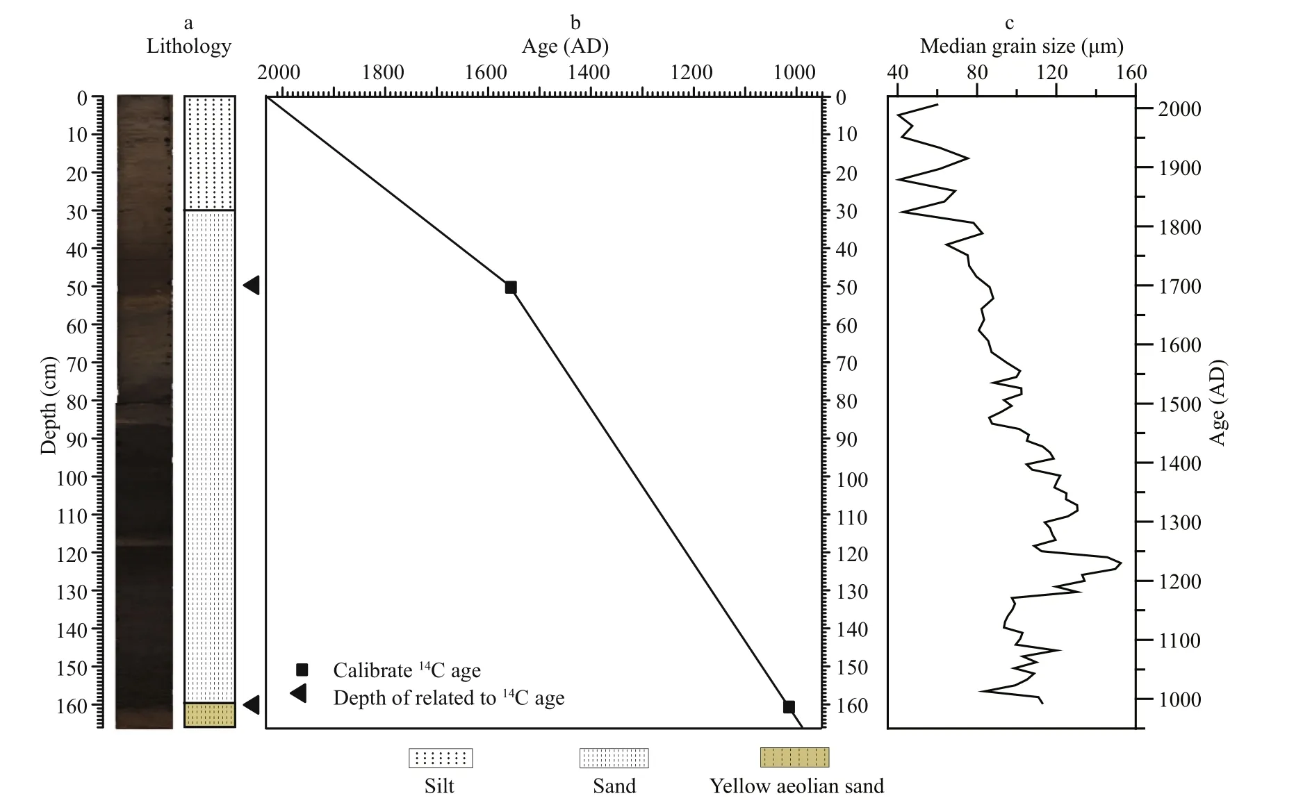
Fig.2 Core photograph (a), age-depth model (b) and the median grain size distribution (c) in the sedimet core AGE15A

Table 1 AMS 14 C ages from Anggertu Lake
3.2 Fossil pollen data
A total of 22 pollen types (families / genera) were identified in the 83 pollen samples. Pollen spectra show that herb pollen types dominate the pollen assemblages. Amaranthaceae (formerly named Chenopodiaceae) andArtemisiaare the dominant herb pollen components. Some other herb pollen types include Poaceae, Cyperaceae, Asteraceae,Ranunculaceae and Polygonaceae. Shrub pollen types are dominated byEphedra,Nitraria, and Rosaceae.In addition, a few arboreal pollen types including Pinaceae,Betula,Alnus,Salix, andQuercusare present. There are also some aquatic pollen types such asTypha, with high proportions at a specific time interval. Figure 3 shows that the main pollen types(Artemisiaand Amaranthaceae) dominate the sediment core, followed by Poaceae and Cyperaceae.The pollen diagram was divided into two pollen assemblage zones (A, B) and five subzones (A-1, A-2,A-3; B-1, B-2) by CONISS results, grain size, and LOIorg. Details of the two pollen zones and five subzones are as follows:
Zone A (166–75 cm, 988–1437 AD)
The pollen assemblages in this zone are dominated primarily byArtemisiaand Amaranthaceae, with a high proportion ofThypaat a specific time interval.This zone is characterized by generally low pollen concentrations (mean 31.6×10³grains/g), with an average A/C ratio of approximately 1.5.
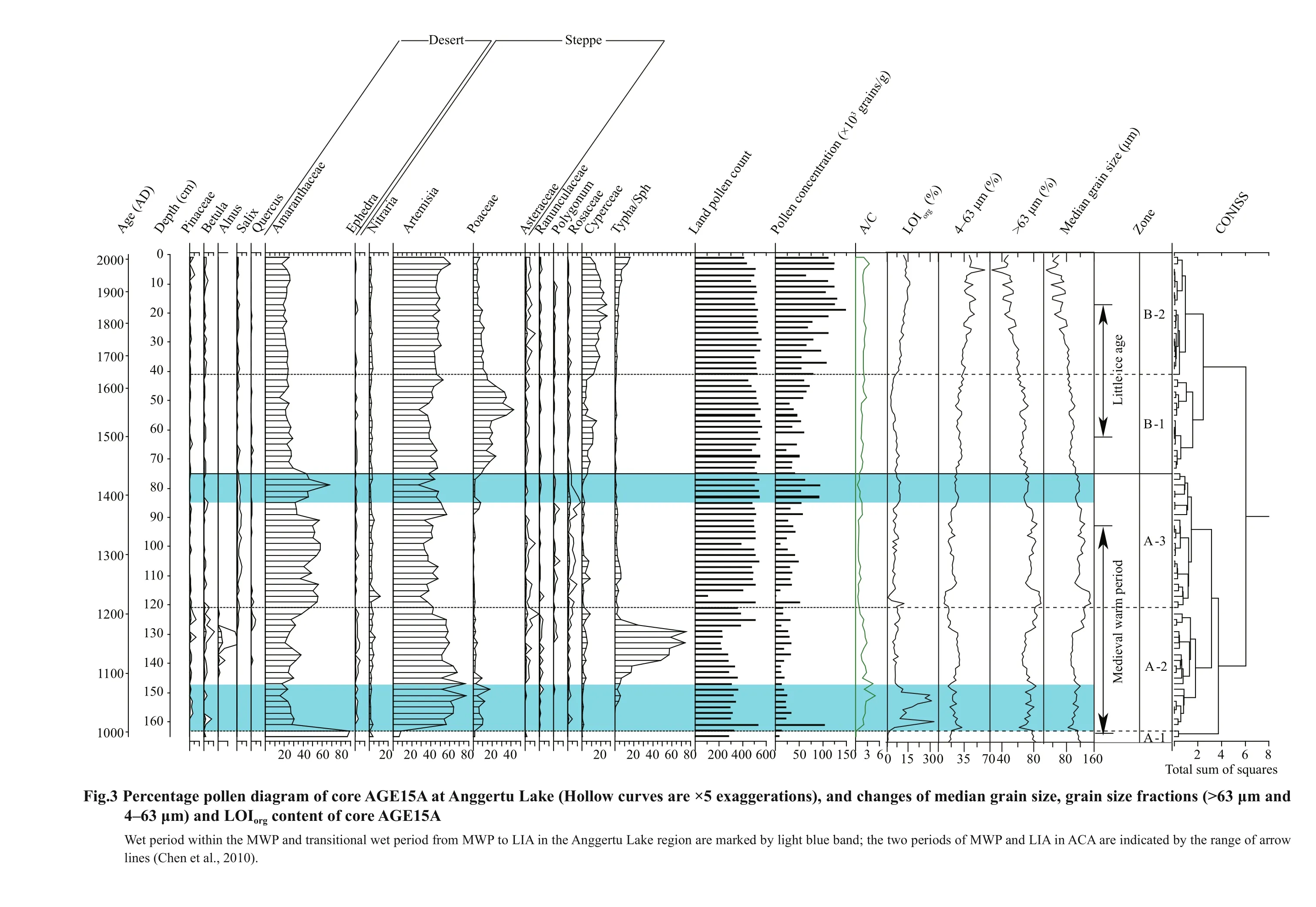
Subzone A-1 (166–163 cm, 988–1003 AD)
This zone is characterized by an abundance of Amaranthaceae pollen (mean 87.9%) and a limited number of pollen taxa. TheArtemisia(mean 7.6%)and Poaceae (mean 1.7%) contents are lower than in other subzones. The pollen concentrations (mean 9.4×10³grains/g), A/C ratios (mean 0.1), and LOIorgvalues (mean 1.3%) were the lowest in the sediment core.
Subzone A-2 (163–121 cm, 1003–1210 AD)
Pollen taxa clearly increase in this subzone.Artemisiaand Amaranthaceae are the dominant pollen components. The former increases markedly to 58.0%while the latter decreases to 27.9% on average. The Poaceae content decreases from 17.5% to 0.4% (mean 4.8%), but remains higher than in Subzone A-1. The mean percentage of Cyperaceae is 2.8% and small amounts of Pinaceae (mean 0.3%) and Betulaceae(mean 1.3%) are present. Notably, this zone is characterized by a high proportion ofTypha(maximum 74.9%, mean 22.2%). Pollen concentrations (mean 23.3×10³grains/g) increase significantly but exhibit large fluctuations from 103.1×10³grains/g (around 1013 AD) to 7.1×10³grains/g. These fluctuations are generally consistent with the changes in A/C ratios (mean 2.3,5.0–0.9) and LOIorgvalues (mean 10.5%, 32.7%–2.8%).
Subzone A-3 (121–75 cm, 1210–1437 AD)
Artemisiaand Amaranthaceae remain the dominant pollen components throughout this subzone. The Amaranthaceae (mean 48.5%) content increases markedly, whileArtemisiafalls to 40.8% on average.The Poaceae content decreases to an average of 1.7%.Cyperaceae varies from 8.9% to 0.2% (mean 2.4%).Nitrariais consistently present (mean 2.5%) in the sediment core, reaching the maximun in this subzone.TheTyphacontent suddenly decreases from 20.3% to 2.4%. Average pollen concentrations increase to 40×103grains/g, but are relatively high at 93×103grains/g during 1388–1437 AD, which corresponds to the LOIorgincreases in this interval.Overall, A/C ratios (mean 0.9) and LOIorgvalues(mean 6.6%) are typically low, while the median grain size is relatively coarse.
Zone B (75–0 cm, 1437–2015 AD)
Artemisia, Amaranthaceae, Poaceae and Cyperaceae are the major pollen components in this zone. Pollen concentrations (mean 75.9×10³grains/g) and A/C ratios (mean 2.0) are generally high.
Subzone B-1 (75–41 cm, 1437–1642 AD)
Pollen assemblages in this subzone includeArtemisia, Amaranthaceae, and Poaceae. The percentage ofArtemisiais relatively high (mean 41.4%) while the Amaranthaceae content decreases to an average of 24.2% and Poaceae reaches its maximum value with a mean of 23.0%. Cyperaceae(mean 7.6%) exhitbits a slight increase.Typhais consistently at a low value (mean 0.8%) in this subzone. The average pollen concentrations and A/C ratios increase to 48.6×10³grains/g and 1.8,respectively. The mean LOIorg(5.8%) does not change significantly.
Subzone B-2 (41–0 cm, 1642–2015 AD)
This subzone is characterized by theArtemisia-Amaranthaceae - Cyperaceae pollen assemblage. A notable feature is the increase in Cyperaceae, which reaches its maximum value of 17.9% within this zone.Artemisiaand Amaranthaceae account for 41.4% and 22.1% on average, respectively. The Poaceae content decreases to 7.2%, a sharp decrease when compared with subzone B-1.Typhaincreases gradually from 1.3% to 15.8% (mean 4.5%). In general, the pollen concentrations (mean 99.2×10³grains/g), A/C ratios(mean 2.2), and LOIorgvalues (mean 12.2%) are generally high, and their trends increase in this subzone.
3.3 Grain size and LOI org data
Figure 3 shows that median grain size, grain size fraction (>63 μm and 4–63 μm), and LOIorgvariations exhibit opposing trends. At a depth of 166–75 cm(988–1437 AD), the values of median grain size and>63 μm fraction are generally higher (mean 114 μm and 76%, respectively), while the 4–63 μm fraction and LOIorgare relatively low (mean 20% and 8.3%,respectively). One exception is the LOIorgmaximum(mean 32.7%), which occurs between 163 cm and 147 cm (1003–1082 AD). The results show gradually decreasing median grain sizes and >63 μm fraction trends, while the LOIorgand 4– 63 μm fraction exhibit opposing trend from 75 to 0 cm (1437–2015 AD).Overall, the grain size fraction (4–63 μm) and LOIorgvariations are generally similar to those of the pollen concentration and A/C ratio.
4 DISCUSSION
4.1 Vegetation history of the Anggertu Lake region since 988 AD
The pollen record from the AGE15A core documents two major changes in vegetation since 988 AD. Detailed descriptions are presented as follows:
Stage I (988–1437 AD, Zone A)
High percentages ofArtemisiaand Amaranthaceae,together with generally low pollen concentrations,indicate that desert and/or desert steppe vegetation was present in the study area. Based on the AGE15A core location, extremely high percentages ofTyphaindicate a relatively shallow lake between 1082 and 1210 AD (Wen et al., 2010). Previous studies have also shown thatTyphafrom the lake sediment has different environmental implications, which depend primarily on the drilling positions in the lake (Wen et al., 2010; Chen et al., 2013). The pollen concentration and A/C ratios fluctuate significantly, which suggests an unstable lacustrine environment. According to changes in the major pollen taxa, the vegetation history of the stage I can be divided into three substages.
The study area was dominated by desert between 988 and 1003 AD (A- 1). Extremely high percentages of Amaranthaceae pollen (mean 87.9%) and low A/C ratios (mean 0.1), together with the lowest pollen concentration (mean 9.4×10³grains/g), suggest an extremely dry climate and few types of vegetation.Previous modern pollen studies (Li et al., 2005; Xu et al., 2007) have indicated that the percentage of Amaranthaceae is higher than 50% in desert vegetation, while pollen concentrations and A/C ratios are lower than 10×103grains/g and 0.5,respectively. Thus the lake district was covered by Amaranthaceae desert vegetation. Pollen taxa and pollen concentrations increased considerably between 1003 and 1210 AD (A- 2), indicating a gradual change to a better lacustrine environment. Amaranthaceae decreased significantly but remained the main component. High A/C ratios likely resulted from higher production ofArtemisiapollen andArtemisiacontributed much of the total pollen concentration,indicating a relatively wet climate in the lake region.Therefore, it could be concluded that the lake region was mainly covered by steppe desert vegetation,which was dominated by Amaranthaceae andArtemisia. Meanwhile, meadow vegetation began to develop around the lake in this sub-stage, which can be inferred from slight increases in Cyperaceae. In generally, Cyperaceae is higher than 20% in alpine meadow vegetation (Xu et al., 2007), but has difficulty spreading over long distances. Thus, the relatively low percentage of Cyperaceae pollen may reflect meadow vegetation around the lake (Shen et al., 2006;Liu et al., 2016). The extremely high pollen concentration shown in Fig.3 is probably related to the temporary ponding environment around 1013 AD(Chen et al., 2013). This is also true of the increased Poaceae andArtemisiapollen, and lack of aquatic pollen (e.g.,Typha). Historical documents also recorded a flood event in 1014 AD in neighboring Longxi (Tan et al., 2008). However, as previously mentioned, a notable feature of this period is an increasedTyphacontent during the 1082–1210 AD(A-2), which indicates a decline in the lake level (Wen et al., 2010). Meanwhile, increases in xerophyticNitrariaand external arboreal pollen reveal further deterioration of the lacustrine environment. In summary, the regional environment generally improved relative to the previous sub-stage, but was not stable. Between 1210 and 1437 AD (A- 3), this region was covered by desert steppe vegetation,which was dominated by Amaranthaceae andArtemisia. Although the pollen concentration continued to increase,Artemisiaand Amaranthaceae remained the main components. A/C ratios were generally low during most of this period, indicating that Amaranthaceae contributed significantly to the pollen concentration and that the effective moisture decreased in the study region. The pollen spectra suggest that the percentages of desert components(e.g., Amaranthaceae andNitraria) increased significantly, whileArtemisia, Poaceae, and Cyperaceae percentages decreased sharply relative to the previous sub-stage. This clear contrast indicates a persistent dry condition, and decreased meadow vegetation dominated by Cyperaceae surrounding the lake. However, pollen concentrations reached as high as 93×103grains/g from 1388 to 1437 AD, together with slight increases in LOIorgvalues and 4–63 μm fraction. At the same time, median grain sizes and>63 μm fraction decrease. This indicates a better lacustrine environment during this interval (Fig.3).
The significant increase in Amaranthaceae and decrease in Poaceae may be related to human overgrazing activities in addition to the relatively dry climate between 988 and 1003 AD (A- 1) and 1210 and 1437 AD (A- 3) (Mercuri, 2008; Wen et al., 2010).Wang et al. (1996) have suggested that A/C ratios can reflect human overgrazing activities, which affect local vegetation to some extent. In this paper,relatively low A/C ratios indicate intensified human acativity during these two intervals. Moreover, the successive rises of the Liao (907–1125 AD), Jin(1115–1234 AD) and Yuan (1206–1368 AD)Dynasties of nomadic people in northern China may also be responsible for increases in Amaranthaceae plants.
Stage II (1437–2015 AD, Zone B)
Overall, pollen concentrations followed a gradually increasing trend, even thoughArtemisiaand Amaranthaceae remained the parimary components during this stage. The marked increase in the proportions of Poaceae and Cyperaceae, and the generally high A/C ratio suggested an expanded steppe and a relatively humid lacustrine environment.The lake region was dominated byArtemisia-Amaranthaceae-Poaceae steppe desert or steppe vegetation, while meadow vegetation expanded around the lake.
Based on the variation among pollen taxa, the vegetation history in this stage can be further divieded into two sub-stages. During 1437–1642 AD (B- 1), the percentage of Amaranthaceae (desert component)decreased significantly relative to the previous substage. Meanwhile, increases in wetland herbs(Poaceae and Cyperaceae), together with high A/C ratios, show a wet climate. The percentage of Poaceae was typically higher than 10%, indicating an expansion of steppe over desert and a relatively humid environment (Li, 1998; Cour et al., 1999; Yu et al.,2001; Herzschuh et al., 2003; Li et al., 2005; Shen et al., 2006; Zhao et al., 2007). Therefore, the lake region was covered by relatively humid steppe desert or steppe dominated byArtemisia, Poaceae, and Amaranthaceae during this sub-stage, while meadow vegetation surrounded the lake. Moreover, the relatively high percentage of Poaceae (mean 23.0%)is associated with intensified agricultural activities(Sadori et al., 2004; Mercuri, 2008; Li et al., 2007,2012; Zhao et al., 2012; Chen, 2012). Meanwhile,fieldwork investigations have found plentifulPhragmitesaustralisin Anggertu Lake, so it could be inferred thatPhragmitesalso may contribute to the high percentage of Poaceae pollen. However,similarities in pollen morphological features make identifying different Poaceae genera difficult. Similar phenomena also occur in other lake regions (Chen,2012; Li et al., 2016). The sub-stage that covers 1642 to 2015 AD (B- 2) was characterized by high pollen concentrations and A/C ratios, which indicate a persistent humid lacustrine environment.Artemisia,Amaranthaceae, and Cyperaceae were the main pollen taxa, and the lake region was covered by steppe desert. The relative pollen abundance of Cyperaceae indicates that meadow vegetation expanded around the lake. At the same time, markedly decreased Poaceae content may have resulted from diminished agricultural activities. However, the 4–63 μm fraction/ median grain size and >63 μm fraction frequently exhibit fluctuations, but remain at relatively high /low levels respectively after 1842 AD (Fig.3). Pollen concentrations, LOIorgvalues, and A/C ratios remian high (Fig.4). Thus, there is an unstable lacustrine environment, even though the climate is generally humid during this period.
4.2 Climate changes of the Anggertu Lake region since 988 AD
Our proxies (e.g., pollen concentrations, A/C ratios, LOIorgvalues and median grain sizes) from Anggertu Lake exhibit distinctly different characteristics during 988–1437 AD (Zone A) and 1437–2015 AD (Zone B) (Fig.4).
988–1437 AD (Zone A): a dry climate prevailed,but was interrupted by two short humid periods(1003–1082 AD and 1388–1437 AD)

Fig.4 Comparisons of climate changes recorded by various proxies from Anggertu Lake sediments and other climate records
Pollen concentrations, A/C ratios and LOIorgvalues generally vary, following a low / high / low / high pattern. The median grain size fluctuates in a coarse /fine / coarse / fine pattern from 988 to 1437 AD(Fig.4). Thus, the climate is not stable, and experiences successive dry / wet / dry / wet intervals during this period. However, the lake region was covered by desert or desert steppe, and presented a relatively dry climate condition during the most of the period. Low pollen concentrations, A/C ratios, and LOIorgvalues,together with coarser grains, indicate dry conditions,and desert vegetation dominated the lake region between 988 and 1003 AD. However, extremely high in A/C ratios and LOIorgvalues indicate rising lake region effective moisture and bio-productivity from 1003 to 1082 AD, although the grains became slightly coarse. Next, a long dry period occurred between 1082 and 1388 AD. The percentage of desert components (Amaranthaceae) increased significantly,while steppe vegetation (Artemisiaand Poaceae)decreased markedly. This corresponds well to the continuous decreasing effective moisture and bioproductivity of the lake, as well as the presence of coarser grains during this period. In particular, high percentages ofTyphasuggest that Anggertu Lake shrank from 1082 to 1210 AD. Therefore, it could be concluded that a dry climate prevailed from 1082 to 1388 AD, generally corresponding to the MWP.Previous studies support the idea that the MWP was characterized by dry conditions in many regions. For example, lake sediment records revealed a relatively dry condition during the period of 900–1200 AD in Juyanhai Lake (Zhang et al., 1998b). Vegetation deterioration was also indicated by a decrease in pollen concentration between 870 and 1350 AD in Ganxu Nur (Chen, 2012). High A/C ratios have previously been recorded at Lake Bosten, Xinjiang during 1000–1500 AD (Chen et al., 2006b). A low glacial accumulation rate in the Guliya ice core suggested a warm, dry MWP period (Yang et al.,2009). He et al. (2013) used alkenone indices UK'37and %C37:4to reconstruct high-resolution temperature and moisture changes on the northern Tibetan Plateau,suggesting substantially drier conditions during the MWP. Recent studies (Yang et al., 2009; Chen et al.,2010) further suggest that MWP exhibited relatively dry conditions in arid central Asia. This was established based on various paleoclimate archives such as ice cores, tree rings, lake sediments, historical documents, and archeological data. As shown in Fig.4, Chen et al. (2010) synthesized a decadalresolution moisture curve for ACA over the past millennium, suggesting a warm-dry climate during the MWP. The result show general consistent variations with low pollen concentrations and A/C ratios, as well as coarse grains in Anggertu Lake from 1082 to 1388 AD. However, the period of 1388–1437 AD exhibited increased lake biological productivity,as suggested by relatively high LOIorgvalues and pollen concentrations in the lake region, which indicate rising humidity during the interval. However,low A/C ratios are associated with increased Amaranthaceae pollen, which may be caused by human grazing activities. Similarly, the tree-ring record from Qilian juniper indicated an increase in regional precipitation during 1310–1420 AD (Yang et al., 2014). A study of soluble salts from Juyanhai Lake sediments indicates that a wet period occurred around 1350–1550 AD (Zhang et al., 2004). Yang et al. (2009) and Chen et al. (2010) have also suggested that the climate was relatively humid around 1300–1500 AD in the ACA. The aforementioned time period occurred during the transition from the warm-dry MWP to the cold-wet LIA.
1437–2015 AD (Zone B): a gradual trend towards a wetter environment
The extremely high percentages of Poaceae and Cyperaceae from 1437 to 1842 AD indicate successive expansions of steppe and meadow vegetation during this period. The high effective moisture and bioproductivity levels recorded in the Anggertu Lake region, together with grains that gradually became finer, could be regarded as a direct response to the optimal climate. The lacustrine environment is characterized by steppe desert or steppe vegetation and the expansion of meadow, and showed a relatively humid climate from 1437 to 1842 AD. This is generally consistent with the climatic conditions during the LIA in ACA (Chen et al., 2010) (Fig.4). A recent study (Chen et al., 2015) further suggests that the climate was generally wetter during the LIA than in the MCA in ACA. In addition, lake sediment records from Juyanhai indicate increased vegetation coverage, a humid climate, and an expanded lake area during the LIA (Zhang et al., 1998b; Zhang et al.,2004a; Chen, 2012). Reconstruction of groundwater in the southern margin of the Badain Jaran Desert suggested a high level of groundwater recharge during 1291–1800 AD (Ma et al., 2003). This wet LIA was also recorded in other regions such as Xinjiang (Chen et al., 2006b) and the northeastern Tibetan Plateau(Chen et al., 2009; Yang et al., 2009; He et al., 2013).Overall, these evidences generally show that the climate was relatively wet during the LIA. However,although the bio-productivity and effective moisture were relatively high, the lacustrine environment was not stable, as indicated by frequent fluctuations in proxies (pollen concentration and grain size) in the Anggertu Lake region after 1842 AD.
In summary, temperature and precipitation/effective moisture are generally negatively correlated over the last millennium in Anggertu Lake (Fig.4). In addition, this study describes two typical climate events, the MWP (1082–1388 AD) and the LIA(1437–1842 AD), the respective the climatic characteristics of which are generally consistent with a warm, dry MWP and a cold, wet LIA in ACA.
5 CONCLUSION
Vegetation history and climate evolution have been reconstructed using fossil pollen, LOIorgvalues, and grain size records from the AGE15A sediment core in Anggertu Lake during the last millennium. The results show the following:
(1) The record can be divided into two major zones.In Zone A (988–1437 AD), vegetation was mainly dominated by desert or steppe desert. Successive appearances of high percentages ofTyphaand desert components (Amaranthaceae) indicate that the lake shrank and the climate was dry during 1082–1388 AD. However, the dry condition was interrupted by two short wet periods: 1003–1082 AD and 1388–1437 AD. During Zone B (1437–2015 AD), the lake region was dominated byArtemisia-Amaranthaceae-Poaceae steppe or steppe desert vegetation, and meadow vegetation gradually expanded around the lake. The relatively high effective moisture and lake bioproductivity suggest a wet climate. An unstable lacustrine environment was indicated by frequent fluctuations in sediment proxies after 1842 AD.
(2) This study also showed that a warm, dry climate prevailed between 1082 and 1388 AD, whereas cold,wet conditions were present in 1437–1842 AD. These conditions correspond well to the MWP and LIA,respectively, and are also generally consistent with ACA climate characteristics.
(3) Regional vegetation variation can reflect human activities (e.g., overgrazing and agricultural activities)in addition to regional climate changes. For example,human overgrazing acativities occurred during 988–1003 AD and 1210–1437 AD. These time periods correspond to successive dynasties of nomadic people in northern China. In addition, intensified agricultural activities contributed to the extremely high percentage of Poaceae in the Anggertu Lake region during 1437–1642 AD.
In order to precisely describe the regional environmental history over the last millennium,studies of vegetation and climate history in neighbouring areas (e.g., the Moon Lake) (unpublished data) will be performed in the future. The Moon Lake data includes high-resolution chronological sequences and pollen data from topsoil samples, which may provide better conditions for further research.
6 DATA AVAILABILITY STATEMENT
The datasets analyzed during this study are available from the corresponding author on reasonable request.
7 ACKNOWLEDGEMENT
We sincerely thank the reviewers for helpful suggestions and comments. And we also thank the professional language editor for polishing the language.
猜你喜欢
杂志排行
Journal of Oceanology and Limnology的其它文章
- Neuroanatomy and morphological diversity of brain cells from adult crayfish Cherax quadricarinatus*
- Effects of feeding time on complement component C7 expression in Pelteobagrus vachellii subject to bacterial challenge*
- Cryopreservation of strip spawned sperm using programmable freezing technique in the blue mussel Mytilus galloprovincialis*
- Pf- D mrt4, a potential factor in sexual development in the pearl oyster Pinctada f ucata*
- Specific genetic variation in two non-motile substrains of the model cyanobacterium Synechocystis sp. PCC 6803*
- Functional characterization of a Δ6 fatty acid desaturase gene and its 5′-upstream region cloned from the arachidonic acidrich microalga Myrmecia incisa Reisigl (Chlorophyta)*