The Holocene Environmental Evolution of the Inner Hangzhou Bay and Its Significance
2018-12-20LIUYanMAChunyanFANDaiduSUNQianliCHENJingLIMaotianandCHENZhongyuan
LIU Yan, MA Chunyan, FAN Daidu, SUN Qianli, CHEN Jing, LI Maotian, and CHEN Zhongyuan
The Holocene Environmental Evolution of the Inner Hangzhou Bay and Its Significance
LIU Yan1), *, MA Chunyan1), FAN Daidu2), *, SUN Qianli1), CHEN Jing1), LI Maotian1), and CHEN Zhongyuan1)
1),,200062,2),,200092,
The Holocene environmental evolution in coastal area, including deltas and estuaries, is vital to the Neolithic colonization in the eastern China. A 29-m long sediment core XL was obtained from the region between the Taihu Lake and Qiantang Estuary, and multiple analyses on the core sediments have been done to investigate the evolution history of the inner coastal zone of Hangzhou Bay during the Holocene. Six sedimentary facies are identified since the late Pleistocene, including the paleosol at the bottom, overlain by tidal-flat-channel complex (TFC), tidal-distributary-channel (TDC), inner estuarine basin (IEB), subtidal-to-intertidal-flat, and fluvial-plain facies. The TFC and TDC facies are dated to be formed before 8500calyrBP, featured by relatively coarse sediments, high magnetic properties and less abundant foraminifera, denoting the tide-influenced setting with large terrestrial inputs. The IEB facies characterized by the most abundant foraminifera fossils and the lowest sediment magnetic properties, is inferred to be deposited during the maximum flooding period between 8500 and 7900calyrBP. The branch estuary was then infilled by local sediments with a shallowing-upward subtidal-to-intertidal sequence during 7900–4300calyrBP. At last the fluvial plain system developed since no later than 4300calyrBP, favouring the rapid development of Neolithic cultures in the region.
facies analysis; grain size; Hangzhou Bay; environmental magnetism; foraminifera; Neolithic cultures
1 Introduction
Since the Last Glacial Maximum (LGM), rising sea water has flooded incised valleys and many huge estuaries formed. After the rapid rising of sea level in the early Holocene, it eventually slowed down to allow the development of deltas and coastal plains, favouring early human settlement for aquaculture and agriculture at the low- lying coastal zone in the mid-late Holocene. The environmental process is so essential in terms of natural and social development that numerous researches have been taken to look for evidences from the stratigraphic sequences on the present river deltas or estuaries (, Stanley and Warne, 1994; Chen., 2000; Li., 2000, 2002; Hori., 2001, 2002; Hori and Saito, 2007). The evolution of Qiantang Estuary-Hangzhou Bay system (QEHB) has been highly influenced by the Yangtze Delta and Taihu Lake, and it is also famous to have cradled the earliest Neolithic civilizations in Asia (Zhang and Li, 1995; Wang., 2001; Lin., 2005; Zong., 2007; Gao, 2013; Liu., 2015, 2016; Zhang., 2015).
In the East China Sea, the sea level was generally at 130–150m below present sea level (BPSL) during the LGM. As the postglacial sea level rose rapidly, it approached 40m BPSL in the early Holocene, and 5m BPSL around 7000calyrBP, and then minor fluctuations continued till today (Zong, 2004; Liu., 2007; Wang., 2012; Song., 2013). Sea level changes exerted great impact on the QEHB, and previous studies have revealed four major sedimentary facies in relation to the sea level fluctuations since the late Pleistocene, including the incised valley (floodplain and channels), the palaeo estuary, the offshore shallow sea, and the present estuary (Lin., 2005; Zhang., 2014). Holocene environmental changes of the QEHB have also been discussed based on the core data (Lin., 2005; Gao, 2013; Zhang., 2015). However, these studies focused mostly on the outer part of the QEHB, less attention is paid to its inner part that may provide greater insights on the coastal evolution. The Taihu incised valley (TIV) may have formed during the LGM, connecting the Taihu Lake with the Qiantang River. The TIV was later flooded to form a branch estuary during the mid-early Holocene, separating the early Neolithic occupations into two parts on both the Yangtze Delta and the southern QEHB coastal plain (, Li., 1993; Wang., 2001, 2012; Lin., 2005). The infilling of the branch estuary is vital to bridge the Neolithic cultures on each side of the Hangzhou Bay (including the Majiabang, Songze and Hemudu cultures, 7000–5000calyrBP) and foster the late Neolithic Liangzhu civilization (5000– 4000calyrBP) in the region (Liu and Chen, 2012).
To understand depositional evolution history of the inner Hangzhou Bay coast and its linkage with Neolithic development in the region, a sediment core was obtained from the western bank of TIV, several kilometers away from the famous Neolithic site of ancient Liangzhu City (Fig.1) (Liu., 2015). Multi-proxy analyses were conducted such as lithological properties, grain size compositions, environmental-magnetism properties, and microfossil species and abundance, to reveal the depositional environment and its potential linkage to the QEHB evolution. The aim of this study is to reveal the possible linkage between the sea level fluctuation and the environmental evolution along the inner coast of the QEHB. It should shed light on the future study on the Holocene coastal environmental change and the Neolithic development in the central East China.
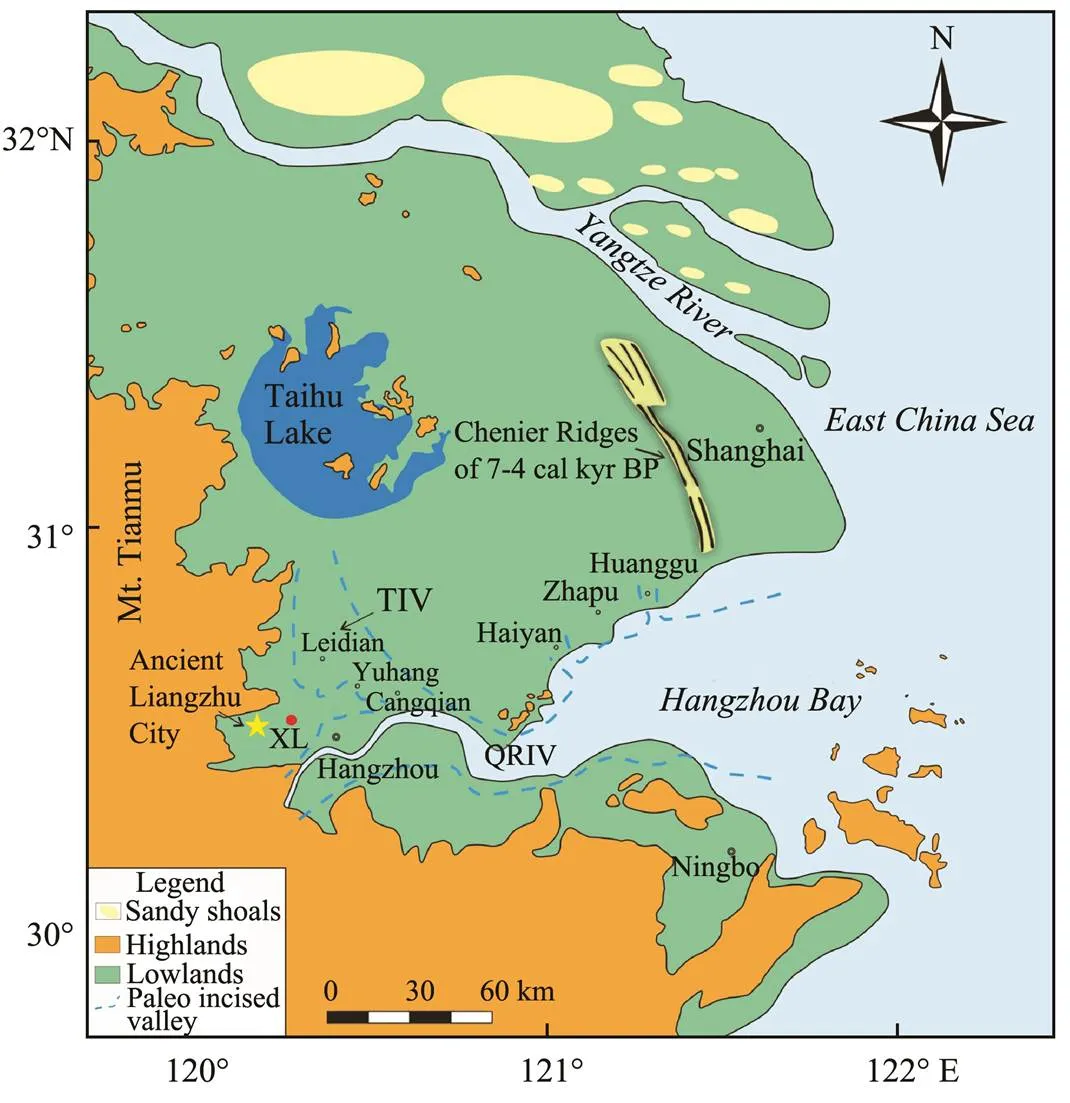
Fig.1 Geographical location of core XL, also indicated are the Yangtze Delta Plain, the Chenier Ridges (after Liu and Walker, 1989), the paleo Taihu incised valley (TIV) and the Qiantang River incised valley (QRIV) (after Lin et al., 2005; Zhang et al., 2015).
2 Geological Settings
The study area is geographically sitting at the foot of Mt. Tianmu, and the junction of the Yangtze Delta and the QEHB (Fig.1). The Hangzhou bay shows a funnel-shaped morphology,, approximately 100km wide at the bay mouth and approximately 20 km wide at the bay head, and is covered by muds primarily transported by the Yangtze River plume (Zhang and Li, 1996; Fan., 2012). The inner Hangzhou Bay overlaps with the Qiantang Estuary (Fan., 2012, 2014). The Qiantang River is approximately 600km long with annual water and sediment discharge of 3.2×10¹⁰m3and 6.6×10⁶t respectively (Pan and Huang, 2010). The limited sediment loads made it not to be considered as the major sediment supplying to the QEHB deposition (Lin., 2005).
Presently, the mean tidal range is <2m at the bay mouth and approximately 5.5m at the inner bay (Fan., 2015). The inner coast of Hangzhou Bay is coalesced to the southwest Yangtze Delta Plain (Fig.1). The average altitude of the coastal plain is 2–5m above mean sea level (amsl), bounding west with hills and mountains of 200– 1000m in elevation. Extensive river networks had developed on the coast since the mid-Holocene, and the Qiantang River flows into the bay at the south of the core site.
The core site was near the west boundary of the TIV in the early to middle Holocene, which has been previously identified by Lin. (2005). The QRIV was located to the south and southeast of the core site (Lin., 2005; Zhang., 2015) (Fig.1). The study area is also known as a concentrated area of Neolithic sites in the mid-late Holocene.
3 Materials and Methods
A 29.0m-long sediment core XL (30˚24΄05″N, 120˚1΄ 40˝E, approximately 2.5m in elevation) was obtained from the coastal area of Hangzhou Bay using an Acker drill rig. Sediment recovery was >95%. The core was logged in the laboratory for the lithology, sedimentary texture and structure, color, and bioturbation. Photographs were taken for the all core sediment samples after core splitting.
In total, sixty-one sediment samples were taken with an interval of 50cm for grain size analysis using Beckman Coulter Laser Diffraction Particle Size Analyzer (LS13320) at the State Key Laboratory of Estuarine and Coastal Research (SKLEC), Shanghai. Samples were pretreated by adding hydrogen peroxide (30%) and diluted hydrochloric acid (10%) to remove organic matter and carbonate minerals, and then were dispersed in an ultrasonic bath for 10 minutes before testing.
The 61 samples were also checked for foraminifera compositions. Samples were sieved through the 63-μm mesh sieve and then dried in room temperature. The procedure follows Wang. (1988). A Nikon microscope at 10× magnification was applied to foraminifera identification.
Environmental-magnetism properties of the core sediments were measured for the 61 samples at SKLEC. Standard procedures of measurement followed Thompson (2012). Measurement of magnetic properties includes the magnetic susceptibility at two frequencies (0.47kHz and 4.70kHz) using a Bartington Instrument MS2, with the noise level at 10−9m3kg−1. The ARM (Anhysteresis Remanent Magnetisation) was obtained by using a Molspin AF demagnetisation instrument. IRM (Isothermal Remnant Magnetisation) was acquired at the following sequence: 1T (considered as Saturation IRM), −20mT, −100mT and −300mT. Magnetic properties used in this study are magnetic susceptibility (χ), Anhysteresis Remanent Magnetisation (arm), χarm/χ, and χarm/SIRM (Saturation Isothermal Remnant Magnetization).
Ten sediment samples were chosen for AMS14C dating, which were previously reported in detail by Liu. (2015). Dating materials include shells (whole and fragments), plant fragments, seeds and woods picked from the core sediments (Table 1). Ages used in the paper are calibrated to years before present (cal yr BP). The age model in the present study is based on linear interpolations of14C ages (Fig.2).
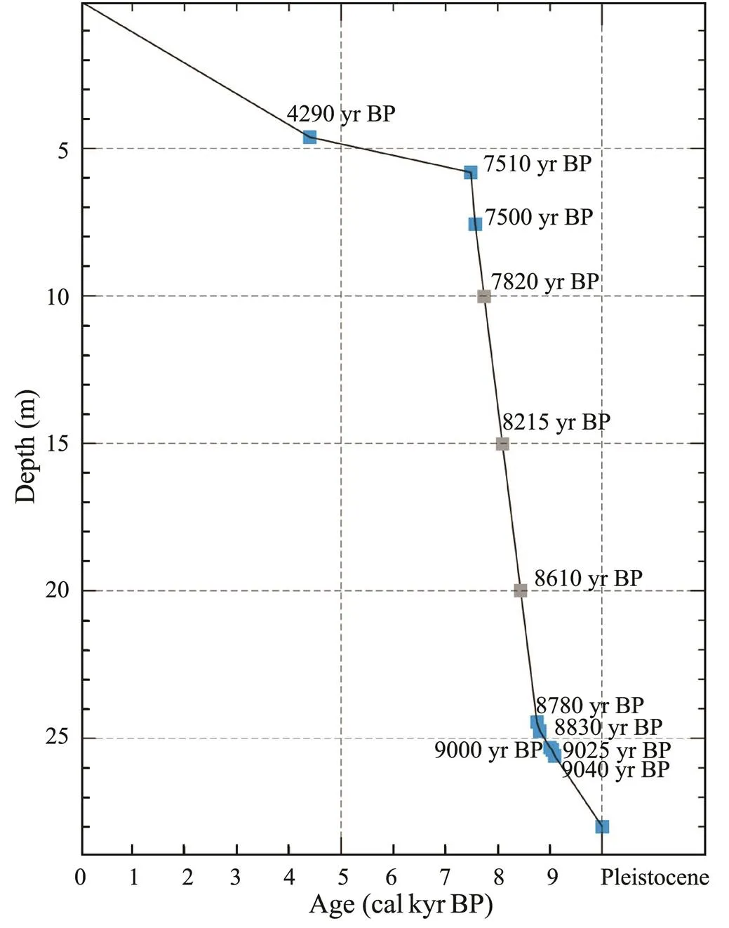
Fig.2 Age-depth model of core XL based on the radiocarbon ages and interpolated ages (those in gray).
4 Descriptions and Interpretations
Core XL penetrates through the Holocene strata and reaches the late Pleistocene sediment layers. Based on sedi- ment lithology, grain size compositions, magnetic properties and assemblages of foraminifera, 6 depositional units were determined in the core XL and described as below.
4.1 Unit I
The unit (29.0–28.0m) is characterized by grayish condensed mud interlayered with brownish clayey silt (Figs.3, 4A). The sediment consists of 42.83% clay and 57.17% silt averagely, but no sand. The mean and medium grain sizes are 7.55μm and 5.08μm, respectively. No foraminifera are found in this muddy layer (Fig.3). Low magnetic properties indicate the scarcity of ferrimagnetic minerals in this layer (Table 2, Fig.3). The unit can be interpreted as paleosol.
4.2 Unit II
Sediments in this unit (28.0–25.6m) consisted of clayey silt. Bedding structures are faint due to high bioturbation, but some thin couplets of silt and clay laminations can be identified through careful examination (Fig.4B). On average, the sediments are composed of 34.58% clay, 63.47% silt, and 1.95% sand. Mean and medium grain size are 12.21μm and 7.23μm respectively. Plant fragments and foraminifera are not identified. The unit has slightly larger χ and SIRM values than the Unit I, but the S-300 ratio is not shown much difference between the two units (Table 2), reflecting the limited input of terrestrial sediments with ferrimagnetic and anti-ferromagnetic minerals (Fig.3). Thus, this unit can be interpreted as tidal flat facies margining the upper reach of tidal river, where the deposition is significantly influenced by tidal-level change to produce tidal laminations, but tidal currents should be weak or absent as indicated by no foraminiferal occurrence (Dalrymple and Choi, 2007; Fan., 2014).
4.3 Unit III
The unit (25.6–19.0m) is characterized by a generally fining-upward trend with decreasing coarse-lamina thickness in sand-mud interbedding, consisting of several fining-upward successions with a sharp erosion base directly overlain by coarse-grained sediments and fine-grained layers (Figs.3 and 4F–4H). The sediment consists of 30.09% clay, 52.95% silt, and 16.96% sand on average. The mean and medium grain sizes were 67.95μm and 43.02μm, respectively. Plant fragments, shells and gastro- pods are rich in the sediments (Figs.4C–4E). The abundance of foraminifera increases upward in the section(Fig.3). The dominant species are,and, commonly seen in the river-mouth setting, suggesting the influence of tidal currents (Fig.3) (Wang., 1988). Most of magnetic parameters increase first, but then decrease upward, reflecting the dissolution of fine grain magnetic domains with increasing water depth (Fig.3). Seven14C-dating samples show a range of ages around 9000–8500calyr BP (Fig.2; Table 1). Thus, this unit is interpreted as tidal influenced distributary channel facies.
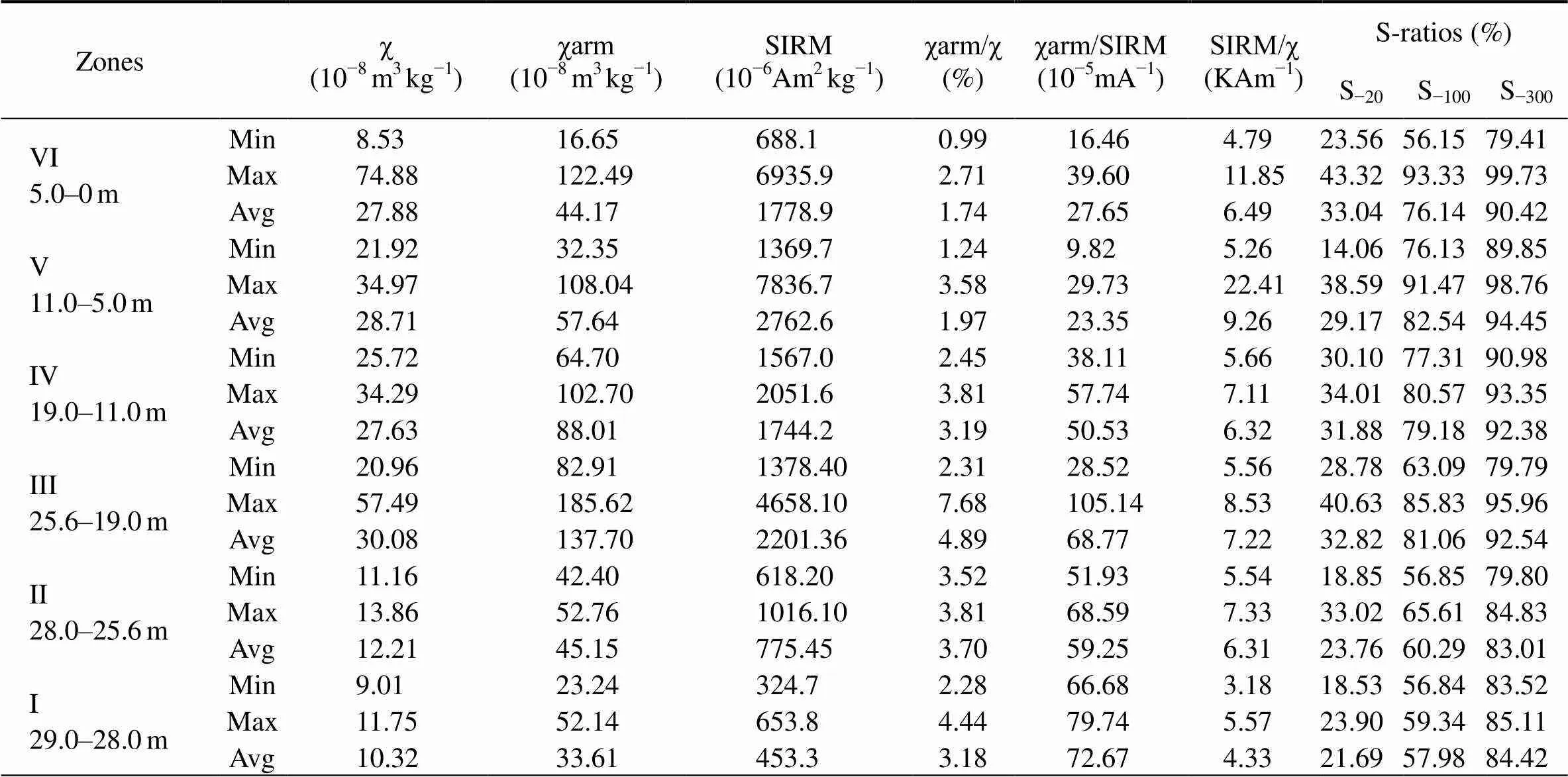
Table 2 Detailed results of sediment magnetic properties in core XL
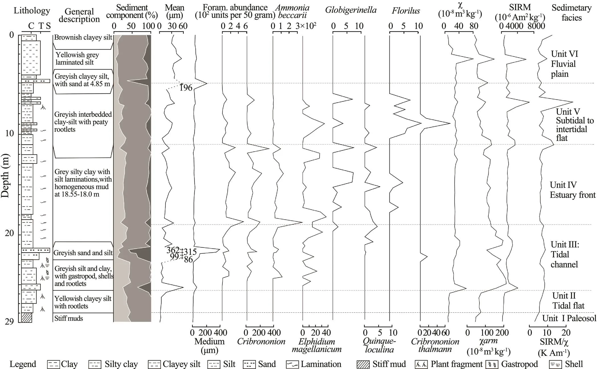
Fig.3 General geological information column of the core XL with six sedimentary units and interpreted facies.
4.4 Unit IV
The unit (19.0–11.0m, approximately 8500–7900calyrBP) is characterized by grayish homogenous mud at the bottom, and thin sand-mud interbedding at the middle and upper parts with upward increasing of coarser components in terms of both lamina thickness and grain size (Figs.3, and 4I–4M). The sediment is featured by relative high (92.5%) mud content (27.32% clay, 65.17% silt, and 7.51% sand, respectively), indicating most of the sediment in this unit were settled from the upper water (Hori., 2001). Moreover, some small burrows filled with fine sand are observed. The mean and medium grain sizes are 22.69μm and 12.32μm, respectively. The unit has the highest foraminiferal diversity and abundance in the core (Fig.3). The abundances of,andsuggest the relative deep water setting and high marine impact (Wang., 1988). Magnetic properties further decrease, then remain stable (Fig.3; Table 2). Thus, this unit is interpreted as inner estuarine basin.
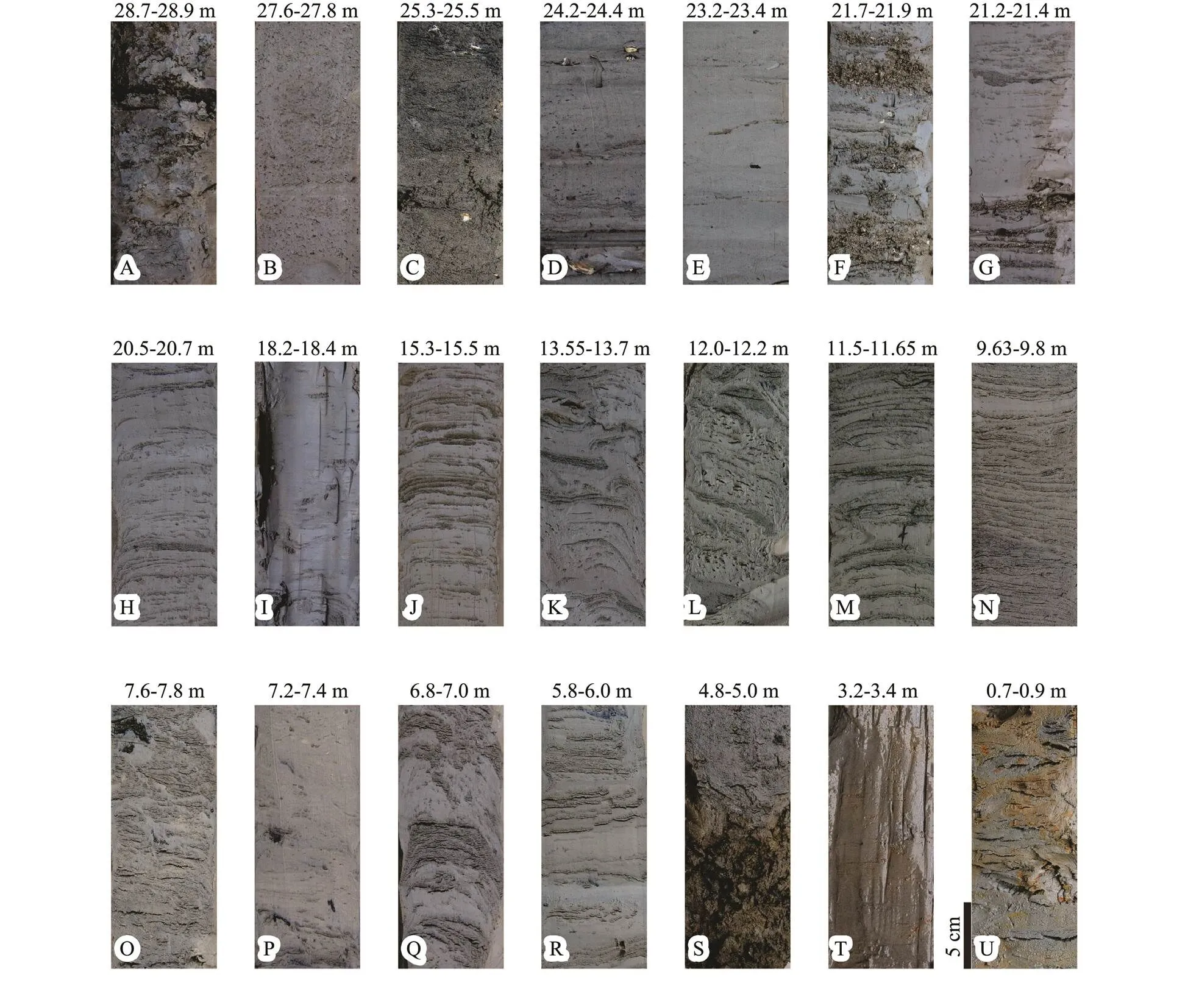
Fig.4 Photos of distinctive sediment structures at different level in core XL.
4.5 Unit V
Two14C ages at 5.9m and 7.6m in this unit (11.0–5.0 m) are 7510 and 7500calyrBP respectively (Fig.3; Table 1). The sediments comprise mainly clayey silt with fine silt laminations. Cyclic sequences of coarsening- and then fining-upward trend were observed (Figs.4N–4R). Charred plant fragments and rootlets occurred occasionally. Clay content declines to 21.63%, while silt and sand content increased to 71.55% and 6.8%. The mean and medium grain sizes are 24.25μm and 17.5μm, respectively. The total abundance of foraminifera decreases. However, the abundances ofandincrease asanddecrease (Fig.3). SIRM and SIRM/χ increase upward and show the highest value throughout the core, but other magnetic properties declined (Fig.3, Table 2). This unit can be interpreted as a sequence shoaling upward from subtidal to intertidal flat facies, with the lower coarsening-upward subtidal succession produced by increasing total energy from the estuarine basin toward the lower intertidal flat, and the upper fining-upward intertidal succession from the lower to higher intertidal flats (Fan., 2014).
4.6 Unit VI
14C dating provides an age of 4290calyrBP at the core depth of 4.87m. The facies (5.00–0m) contains mainly grayish silt with a sharp contact with the underlying the facies-V (Fig.4S), but the topmost 0.75-m section has altered to brownish (Figs.4T, 4U). Clay accounts for 11.72%, silt for 70.32%, and sand for 17.96%. The mean and medium grain sizes are 53.62μm and 47.79μm, respectively. Foraminifera are not observed throughout this section (Fig.3). Magnetic properties increase at the bottom part but decrease at the top except for SIRM/χ (Fig.3). This unit is interpreted as fluvial plain facies.
5 Discussion
5.1 Holocene Depositional Evolution in Relation to Sea Level Fluctuations
The geographic location of the core was at the junction of the paleo Qiantang River incised valley (QRIV) and the paleo Taihu incised valley (TIV, Fig.1). The dense sediments in the Unit I were widely distributed over the Yangtze Delta Plain and northern Jiangsu coast plain, and termed as ‘stiff mud’ (Chen and Stanley, 1995) (Fig.3). This layer was recognized as the sedimentary basement of the late Pleistocene, formed due to the strong pedogenesis during the LGM (Qin., 2008), when the sea level was over 120m below the present one (Uehara and Saito, 2003; Liu., 2007).
The Holocene strata could be subdivided into transgressive and retrogressive sequences. The transgressive sequence started at the beginning of the Holocene epoch. It was characterized by the first presence of coarser sediments with relatively higher values of χ and SIRM but none of foraminifera, indicating that the river began to over-flood the incised valley due to backwater effect of rising sea level before 9000calyrBP (Fig.3, Unit II). Although the incised valley in the present Hangzhou Bay was assumed to be rapidly filled up during the early Holocene by the coarse sediments from the outer shelf transported by currents and waves (Gao, 2013; Zhang., 2014), they probably could not reach the core site in the inner part of the QEHB. The coarse sediments in Unit III could be carried by local tributaries from Mt. Tianmu to the coring site (Lin., 2005).
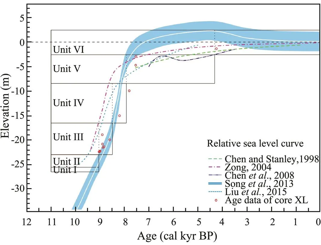
Fig.5 Relative sea-level curve of the East China Sea during the Holocene (after Song et al., 2017). Six units (I–VI) in our core are also integrated.
The occurrence of foraminifera since 9000calyrBP showed the beginning of tidal influence. After approximately 8800calyrBP, marine influence gradually enhanced as reflected by increasing foraminifera abundance in the tidal channel, possibly due to the rapid sea level rise (Zong, 2004; Wang., 2012; Fig.5). The broad spectrum of grain-size from clay to coarse sand, together with abundant foraminifera and shells at Unit III, inferred that the coring site might be occupied by distributary channels with intense tidal influence and sea water invasion (Figs.3 and 5). The fining-upward sequence might indicate the increasing water depth (Figs.3 and 4), as supported by the decreasing χ, χarm and SIRM in response to declining content of single domain magnetic minerals. This feature indicates the reductive environment due to the deep water depth.
This tidal distributary-channel facies was directly over- lain by the thick homogeneous muds occurred in the lower part of Unit IV (Figs.3 and 4I), which could be the deposition of fluid muds in the estuary (Dalrymple and Choi, 2007). The upward decreasing of magnetic properties in the Unit IV was assumed to result from the reductive diagenesis in a deep-water estuary environment during the period of rapid sea level rise (Fig.5; Liu., 2013).
The rapid progradation of the coast of tributary estuary continued in the period 7900–7500calyrBP after the slowdown of sea level rising (Figs.2, 3, Unit V). The upward decreasing in foraminifera abundance suggested the weakening marine influence in a shallow estuarine setting. The presence of charred wood fragments and plant rootlets at the top of Unit V reflected more terrestrial input and finally the seafloor outcropped to support vegetation at the core site. Alterations of coarsening- and fining- upward sequences, as represented by massive bedding, thick silt-clay couplets and silt lamination, indicate the feature of subtidal to intertidal flat facies (Figs.3 and 4N– 4R) (Fan., 2012, 2015).
After 4300calyrBP, an abrupt sediment contact (at the bottom of the sand layer) occurred at 5.0–4.85m (Fig.4S), suggesting the core site has been re-occupied by a local small river. It was then overlain by several meters of silty deposits (Figs.4T and 4U), indicating a fluvial plain environment developed under the stable sea level condition in the late Holocene (Figs.3 and 5, Unit VI).
5.2 Filling-Up of the TIV and Its Neolithic Implications
As discussed above, in the early-mid Holocene sea water inundated the study area and turned it into the estuarine environment before 7900calyrBP. The estuary over the TIV and the QRIV geographically separated the southern coast along Hangzhou Bay from the Yangtze River delta (Yan and Shao, 1989; Lin., 2005; Zhang., 2015). The infilling started after 7800calyrBP, and the area near the coring site turned into an intertidal-flat setting no later than 4300calyrBP (Fig.3).
Archaeological findings revealed that the TIV branch estuary was still a natural barrier for the Majiabang (7000–6000calyrBP) and Songze (6000–5000calyrBP) people, as only a few Neolithic settlements were at the west of the TIV, but numerous Majiabang Neolithic sites were located at its eastern flank (Figs.6A and B) (Liu and Chen, 2012). This situation changed during the Liangzhu cultural stage (5000–4000calyrBP), being coincident with the environmental transition period from subtidal to intertidal settings (Fig.3).
The transition from coastal plain to fluvial plain could be related to the filling-up of the paleo Taihu incised valley (TIV) since the last 4300yrs (Wang., 2001). It was supported by previous findings that the closure of the TIV branch estuary occurred at 4400–4200calyrBP based on several sediment cores and peat dating (Hong, 1991). Also, from the geo-archaeological perspective, the newly emerging sites of middle and late Liangzhu culture on the coastal plain over the paleo-TIV estuary suggested that the filling-up of the branch estuary was no later than middle Liangzhu cultural stage (4800–4300calyrBP) (Fig.6C) (Zheng, 2005). The closure of the TIV estuary provided favorable conditions for the Neolithic cultures, catalyzing the prosperous development of the Liangzhu culture in the central eastern China, including the Yangtze Delta Plain and the southern Hangzhou Bay plain (Liu., 2015).
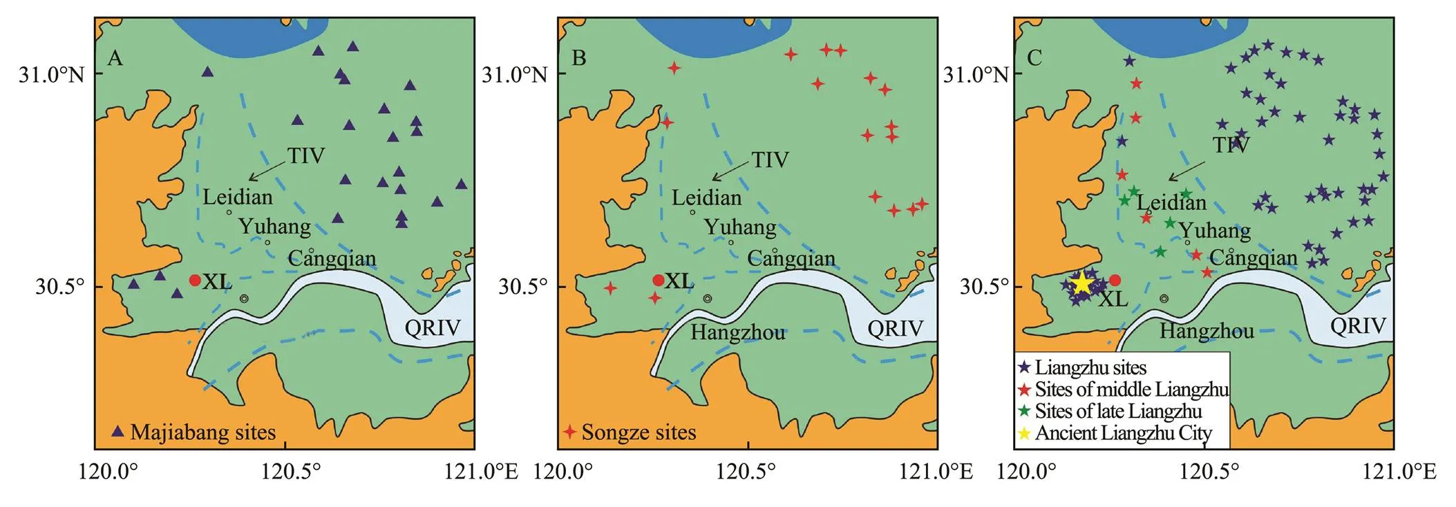
Fig.6 Evolution of the TIV and the sites of Neolithic settlements during 7000–4000 cal yr BP.
6 Conclusions
The palaeo-depositional environment in the study area was closely linked to the regional sea-level and local geo- morphological changes. Before 9000calyrBP, in the area near the core site the tidal flat setting developed over the paleo-interfluve environment dominated by terrestrial sediment input. During the period of 9000–7900calyrBP, it turned into the tidal distributary channel and the inner estuarine basin successively, then connected to the Qiantang Estuary-Hangzhou Bay system because of enhanced marine influence. From then on, the terrestrial influence increased and dominated again after the sea level was stabilized. Core data and geo-archaeological findings suggested the coastal plain formed no later than 4800– 4300calyrBP, boosting the rapid development of Liangzhu culture in this region.
Acknowledgements
This study is financially funded by the National Natural Science Foundation of China (Nos. 41501005, 41476031, 41620104004), and supported by China-ASEAN maritime cooperation fund: Comparative study of Holocene Sedimentary Evolution of the Yangtze River Delta and the Red River Delta. Thanks should be extended to Prof. PB Wignall, University of Leeds for his valuable suggestions and comments. We also appreciate the anonymous reviewers for their constructive suggestions on the previous version of this paper.
Chen, Z., and Stanley, D. J., 1995. Quaternary subsidence and river channel migration in the Yangtze Delta Plain, eastern China., 11 (3): 927-945.
Chen, Z., Song, B., Wang, Z., and Cai, Y., 2000. Late Quaternary evolution of the sub-aqueous Yangtze Delta, China: Sedimentation, stratigraphy, palynology, and deformation., 162 (2): 423-441.
Dalrymple, R., and Choi, K., 2007. Morphologic and facies trends through the fluvial-marine transition in tide-dominated depositional systems: A schematic framework for environmental and sequence-stratigraphic interpretation., 81: 135-174.
Fan, D., Cai, G., Shang, S., Wu, Y., Zhang, Y., and Gao, L., 2012. Sedimentation processes and sedimentary characteristics of tidal bores along the north bank of the Qiantang Estuary., 57: 1578-1589.
Fan, D., Shang, S., Cai, G., and Tu, J., 2015. Distinction and grain-size characteristics of intertidal heterolithic deposits in the middle Qiantang Estuary (East China Sea)., 35 (3): 161-174.
Fan, D., Tu, J., Shang, S., and Cai, G., 2014. Characteristics of tidal-bore deposits and facies associations in the Qiantang Estuary, China., 348: 1-14.
Gao, S., 2013. Holocene shelf-coastal sedimentary systems associated with the Changjiang River: An overview., 32: 4-12.
Hong, X., 1991. Origin and evolution of the Taihu Lake., 11: 87-99 (in Chinese with English abstract).
Hori, K., and Saito, Y., 2007. An early Holocene sea-level jump and delta initiation., 34 (18): L18401.
Hori, K., Saito, Y., Zhao, Q., and Wang, P., 2002. Evolution of thecoastal depositional systems of the Changjiang (Yangtze) River in response to late Pleistocene–Holocene sea-level changes., 72: 88-897.
Hori, K., Saito, Y., Zhao, Q. H., Cheng, X. R., Wang, P. X., Sato, Y., and Li, C. X., 2001. Sedimentary facies of the tide-dominated paleo-Changjiang (Yangtze) Estuary during the last transgression., 177: 331-351.
Li, C. X., Chen, G., Zhong, H., and Liu, B., 1993. Sedimentary sequence and environmental evolution of Qiantang Estuary during postglacial period., 1: 12-24 (in Chinese with English abstract).
Li, C. X., Chen, Q. Q., Zhang, J. Q., Yang, S. Y., and Fan, D. D., 2000. Stratigraphy and paleoenvironmental changes in the Yangtze Delta during the last Quaternary., 18: 453-469.
Li, C. X., Wang, P., Sun, H. P., Zhang, J. Q., Fan, D. D., and Deng, B., 2002. Late Quaternary incised valley fill of the Yangtze Delta (China): Its stratigraphic framework and evolution., 152: 133-158.
Lin, C. M., Zhuo, H. C., and Gao, S., 2005. Sedimentary facies and evolution in the Qiantang River incised valley, eastern China., 219: 235-259.
Liu, C. Z., and Walker, H. J., 1989. Sedimentary characteristics of cheniers and the formation of the chenier plains of East China., 5 (2): 353-368.
Liu, J., Xu, K., Li, A., Milliman, J., Velozzi, D., Xiao, S., and Yang, Z., 2007. Flux and fate of Yangtze River sediment delivered to the East China Sea., 85: 208-224.
Liu, L., and Chen, X., 2012.. Cambridge University Press, New York, 1-482.
Liu, Y., Sun, Q., Fan, D., Lai, X., Xu, L., Finlayson, B., and Chen, Z., 2016. Pollen evidence to interpret the history of rice farming at the Hemudu site on the Ningshao Coast, eastern China., 426: 195-203.
Liu, Y., Sun, Q., Thomas, I., Zhang, L., Finlayson, B., Zhang, W., Chen, J., and Chen, Z., 2015. Middle Holocene coastal environment and the rise of the Liangzhu City complex on the Yangtze Delta, China., 84 (3): 326-334.
Liu, Y., Wang, Z., and He, Z., 2013. Magnetic properties of Holocene core ZK9 in the subaqueous Yangtze Delta and their mechanisms and implications., 7 (3): 331-340.
Pan, C. H., and Huang, W. R., 2010. Numerical modeling of suspended sediment transport in Qiantang River: An estuary affected by tidal bore., 26: 1123- 1132.
Qin, J., Wu, G., Zheng, H., and Zhou, Q., 2008. The palynology of the first hard clay layer (late Pleistocene) from the Yangtze Delta, China., 149 (1): 63-72.
Song, B., Li, Z., Saito, Y., Okuno, J. I., Lu, A., Hua, D., Li, J., Li, Y., and Nakashima, R., 2013. Initiation of the Changjiang (Yangtze) Delta and its response to the mid-Holocene sea level change., 388: 81-97.
Song, B., Yi, S., Chang, T. S., Kim, J. C., Mao, L. M., Nahm, W. H., and Jia, H. J., 2017. Holocene environmental change inferred from multiple proxies in the mouth of Gomso Bay on the west coast of South Korea., 88 (2): 1-13.
Stanley, D. J., and Warne, A. G., 1994. Worldwide initiation of Holocene marine deltas by deceleration of sea-level rise., 265: 228-232.
Thompson, R., 2012.. Springer Science & Business Media, Dordrecht, 228pp.
Uehara, K., and Saito, Y., 2003. Late Quaternary evolution of the Yellow/East China Sea tidal regime and its impacts on sediments dispersal and seafloor morphology., 162: 25-38.
Wang, J., Chen, X., Zhu, X. H., Liu, J. L., and Chang, W. Y., 2001. Taihu Lake, lower Yangtze drainage basin: Evolution, sedimentation rate and the sea level., 41: 183- 193.
Wang, P., Zhang, J., Zhao, Q., Min, Q., Bian, Y., Zheng, L., Cheng, X., and Chen, R., 1988.. Ocean Press, Beijing, 438pp.
Wang, Z., Zhuang, C., Saito, Y., Chen, J., Zhan, Q., and Wang, X., 2012. Early mid-Holocene sea-level change and coastal environmental response on the southern Yangtze Delta Plain, China: Implications for the rise of Neolithic culture., 35: 51-62.
Yan, Q. S., and Shao, X. S., 1989. Evolution of shorelines along the north bank of Hangzhou Bay during the late stage of the Holocene transgression., 32 (3): 347- 360.
Zhang, G., and Li, C., 1995. The infilling of the incised Qiantang River paleovalley and its sequence stratigraphic characteristics., 15: 57-68 (in Chinese with English abstract).
Zhang, G., and Li, C., 1996. Land-ocean interaction in Qiantangjiang Estuarine area since last glaciation., 15: 43-49.
Zhang, X., Dalrymple, R. W., Yang, S. Y., Lin, C. M., and Wang, P., 2015. Provenance of Holocene sediments in the outer part of the paleo-Qiantang River Estuary, China., 366: 1-15.
Zhang, X., Lin, C. M., Dalrymple, R. W., Gao, S., and Li, Y. L., 2014. Facies architecture and depositional model of a macro- tidal incised-valley succession (Qiantang River Estuary, eastern China), and differences from other macrotidal systems., 126 (3-4): 499-522.
Zheng, C. G., 2005. Environmental archaeology on the temporal-spatial distribution of culture sites in Taihu lake area during 7–4 ka BP. PhD thesis. Nanjing University.
Zong, Y., 2004. Mid-Holocene sea-level highstand along the southeast Coast of China., 117: 55- 67.
Zong, Y., Chen, Z., Innes, J. B., Chen, C., Wang, Z., and Wang, H., 2007. Fire and flood management of coastal swamp enabled first rice paddy cultivation in East China., 449: 459-462.
June 7, 2017;
August 21, 2017;
October 30, 2017
© Ocean University of China, Science Press and Springer-Verlag GmbH Germany 2018
E-mail: liuyan@sklec.ecnu.edu.cn E-mail: ddfan@tongji.edu.cn
(Edited by Chen Wenwen)
杂志排行
Journal of Ocean University of China的其它文章
- Comparative Evaluation of Toleration to Heating and Hypoxia of Three Kinds of Salmonids
- Morphological Change in the Northern Red River Delta, Vietnam
- Internal Facies Architecture and Evolution History of Changxing Mouth-Bar Complex in the Changjiang (Yangtze) Delta, China
- Provenance of Sediments Filling a Paleo-Channel that Formed on the Western Yellow Sea Continental Shelf During the Last Glacial Period
- Distribution and Characteristics of Hazardous Geological Features in the Marine Coastal and Offshore Areas of Zhejiang Province, East China Sea
- Characteristics of Heavy Minerals and Quantitative Provenance Identification of Sediments from the Muddy Area Outside the Oujiang Estuary Since 5.8 kyr
