Morphological Change in the Northern Red River Delta, Vietnam
2018-12-20BUIVuongVanFANDaiduNGUYENDacVeTRANDinhLanTRANDucThanhHOANGVanLongandNGUYENThiHongHanh
BUI Vuong Van, FAN Daidu, NGUYEN Dac Ve, TRAN Dinh Lan, TRAN Duc Thanh, HOANG Van Long, and NGUYEN Thi Hong Hanh
Morphological Change in the Northern Red River Delta, Vietnam
BUI Vuong Van1), 3), FAN Daidu2),*, NGUYEN Dac Ve1), 2), TRAN Dinh Lan1), TRAN Duc Thanh1), HOANG Van Long3), and NGUYEN Thi Hong Hanh4)
1),,18000,2),,200092,3),10000,4),,
Coastal erosion has become a worldwide concern, typically in the densely populated Asian mega-river deltas. Severe coastal erosion in the southern Red River Delta (RRD) has been intensively studied. Coastal morphological change in the northern RRD was examined in detail through DEM (Digital Elevation Model) analysis based on time series of bathymetrical maps (1965–2004) and Landsat images (1975–2015) in this study. The results show that the northern RRD is featured by rapid coastal accretion in the past few decades, although suspended sediment flux has dropped by roughly 60% after the completeness of Hoa Binh Dam (HBD) in 1988 and relative sea level rose at 1.9mmyr−1. However, accretion at the outer part of subtidal shoals and platforms was observed to slow down quickly or even turned into erosion in the last two decades. The resuspended sediments from the erosion zone can be transported landward to replenish the inner coastal zone, keeping the latter accretion in the near future to compensate for the sediment discharge decrease from the river. However, this lag effect should be terminated soon if other adverse effects go worse,., damming rivers, sea-level rising, strengthening storms, land reclamation and other poor-designed coastal engineering. Coastal planners and managers should pay full attention to these changes.
Morphological change; DEM; coastal erosion; coastal engineering; coastal management; tide-dominated; Red River Delta
1 Introduction
Deltas are extremely fertile lowlands and have attracted human settlement and farming since their initial development in the mid-Holocene (Stanley and Warne, 1994, 1997; Fan., 2017). Due to easy transport, deltas have developed into worldwide socioeconomic hubs, housing more than 500 million people, with continued growth expected in the near future. However, deltas have been evaluated as the world’s most vulnerable regions in response to global change and human activities because of sinking and shrinking issues (Syvitski., 2007, 2009; Fan., 2017). The situations are typically worsening in populous Asian mega-deltas, where adverse impacts are majorly sourced from damming rivers, sand mining in river channels, and land reclamation from the sea (Li., 2004; Saito., 2007; Syvitski., 2009; Anthony., 2015; Fan., 2017; Xie., 2017).
Red River Delta (RRD) accommodates over 17 milli-non residents (22% of the national total), and provides 20% of the rice production of Vietnam in an area of 17×103km2(Thanh., 2004). This vast deltaplain land has been formed by huge riverine sediment discharge since 8500calyrBP when the postglacial sea-level rise significantly slowed downd and approached to its highest level (Hori., 2004). Annual sediment discharge of the Red River was reported to be 100–160Mt, ranking the 9th in the world (Milliman and Meade, 1983). However, it has dramatically decreased to around 40Mt after the completeness of the Hoa Binh Dam (HBD) in 1988 in the Da River, a major tributary to the Red River (Ha., 2010; Wang., 2011; Vinh., 2014). Combined with other adverse effects of rising sea level, strengthening storms, and increasing human activities in the drainage basin and along the coast, the delta undergoes increased coastal erosion, together with biodiversity reduction (Thanh., 2004; Duc., 2012).
RRD coast stretches over 150km, varying from a tide- dominated setting in the north to a wave-dominated setting in the south. Different coast sectors take diverse response to the change in sediment flux and other drivers. Morhodynamic variation in the southern RRD (south of the Ba Lat Estuary) has been extensively studied because of obvious coastline change and coastal erosion/accretion shifting in the Ba Lat and Day estuaries, and severe erosion along the Hai Hau coast between the two estuaries (Thanh., 2004; Duc., 2012). In the northern RRD, coastline change is relatively slow with a net accretion over the coast, consequently attracting less study. However, some coastal segments in the northern RRD has also been reported to undergo significant erosion, for example, Cat Hai Island (Thanh., 2004). On the other hand, siltation in the tide-dominated estuaries produces big trouble in the waterway, and this is the case in the Hai Phong International Seaport, the second biggest port in Vietnam. Therefore, multi-decadal variations in coastline positions and coastal morphology are examined in this study by a detailed comparison of different-aged nautical charts and remote sensing images with a DEM (digital elevation modeling) method. We aim to better understand morphodynamic change in response to natural and human forcings in the north RRD predominated by tide, and offer insights into coastal planning and management.
2 Study Area
The Red River basin is subject to a subtropical climate, characterized by a winter monsoon from the northeast, and a summer monsoon from the south. The wet season (from May to October) accounts for 85%–95% of the totalyearly rainfall (Vinh., 2014). Accordingly, 90% of the annual sediment discharge debouches into the sea during the wet season (Mathers., 1996). Annual water and suspended sediment discharges of the Red River at Son Tay gauging station before HBD impoundment were 120km3and 120Mt, respectively (Vinh., 2014). These discharges debouch into the Tonkin Gulf through nine distributaries unevenly. Approximately 50% of sediment discharge debouches into the sea through Ba Lat, Day and Ninh Co (minor) rivers in the Southern RRD, and the remnant halves through six distributaries (namely, from north to south, Bach Dang, Lach Tray, Van Uc, Thai Binh, Tra Ly, Lan) in the northern RRD. The subaqueous delta is dominated by muddy deposits.
The RRD coastline stretches 150km from Yen Lap to Lach Truong Estuary (Hoang Yen Cape) with southward decreasing in tidal range but increasing in wave exposure. The tide in the Gulf of Tonkin is predominantly diurnal with spring tidal range decreasing southward roughly from 4 to 2m along the RRD coast (Vinh., 2009; Duc., 2012). The Hon Dau tidal gauging station gave a long- term average spring tidal range of 4.2m (Thanh, 1993; Huy, 1996). The wave direction prevails in northeast (southeast) during the dry (rainy) season. Wave heights are on average 0.7–1.3m with a maximum of 3.5–4.5m, but may reach over 5m during typhoons (Duc., 2007, 2012). The northern RRD coast lies in a shelter from strong wave action by Hainan Island, together with prevalent funnel shaped estuaries, consequently dominated by tidal influence. While, the southern RRD are wave dominated due to less wave sheltered setting and a protruding configuration (Fig.1).
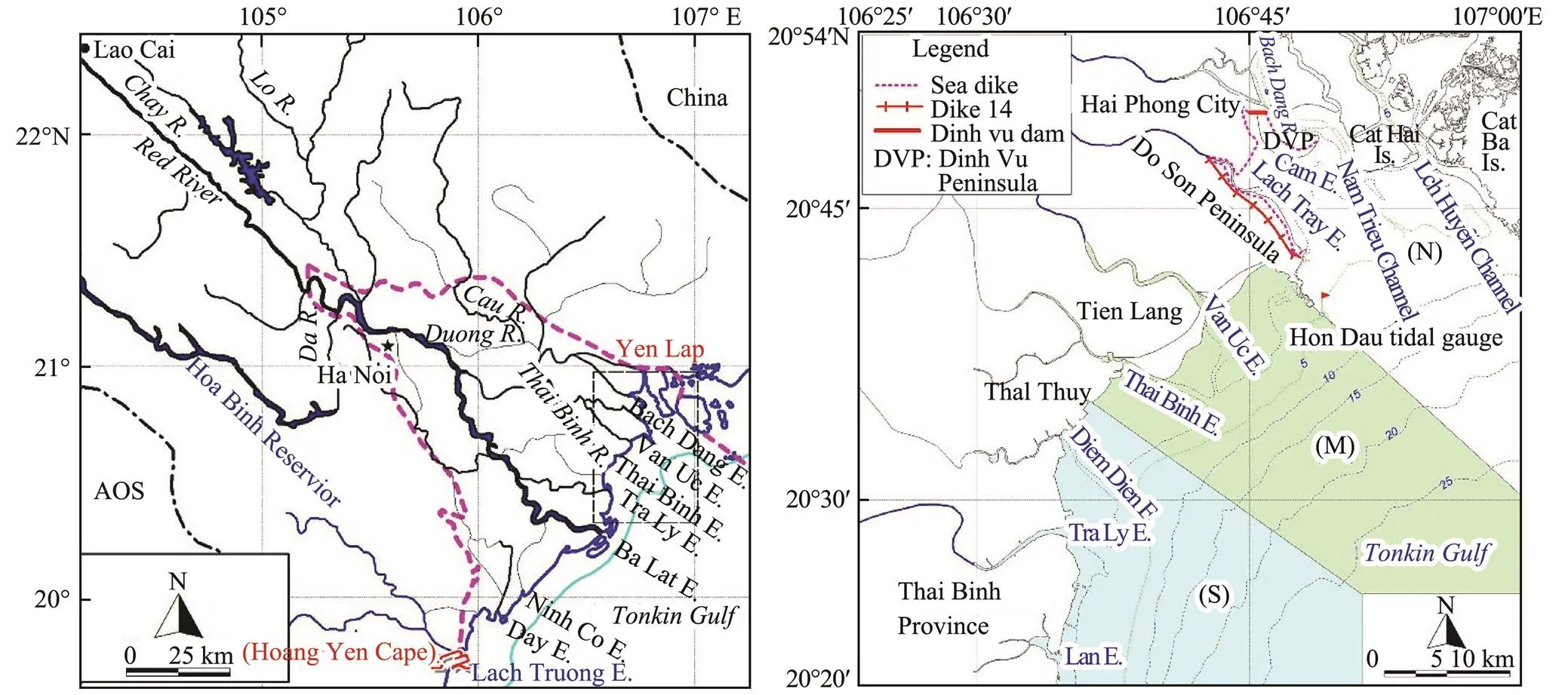
Fig.1 Sketch map of the lower reach of Red River and the Red River Delta (left), and a closeup of the northern RRD with three subdivisions: northern (N), middle (M), and southern (S) sectors (right). E. and Is. are abbreviations for estuary and island, respectively.
The large-scale flow patterns in the Tonkin Gulf are dominated by tidal and monsoon currents. The tidal waves enter the Gulf of Tonkin from the South China Sea and are partly reflected in the northern enclosure of the Gulf. Furthermore, the diurnal components O1 and K1 are near resonance mode in the basin, so the amplitude of these components increases northward along the North Vietnamese coastline (Fang., 1999; van Maren, 2004). Driven by the monsoonal wind patterns, the residual flow in the Gulf of Tonkin exhibits one anti-clockwise rotating cell during the winter monsoon (dry season), with a southward flow near the RRD coast. However, there are two circulation cells in the summer monsoon (wet season), diverging roughly off the central RRD coast. Consequently, the residual flow near the RRD is much weaker in magnitude and more variable in direction during the wet season than during the dry season (van Maren, 2004).
3 Method
3.1 Collection and Processing of Bathymetrical Data
Eleven nautical charts were collected with the time coverage from 1965 to 2004 (Table 1). Bathymetrical data were digitized from the charts through using ARC-GIS 10.1 software. The original bathymetric data are refer-enced to different coordinate systems, and the digital data in this study were standardized to the present Vietnam coordinate VN2000. The water depths in the charts are all referenced to the regional datum (Hon Dau Datum, HD; Fig.1). A DEM (Digital Elevation Model) with 50×50m2resolution was produced for each chart through using the Kriging gridding method. Spatiotemporal variations in deposition and erosion patterns of the northern RRD coast were analyzed by comparison of DEM data from different time periods, and statistics for the area and volume of erosion and deposition were calculated.

Table 1 Information of bathymetrical charts and topographic maps collected in this study
3.2 Collection and Processing of Satellite Image Data
Multi-date Landsat images were chosen to extract coastline and geomorphological change in the northern RRD. We carefully selected twelve Landsat MSS/TM/ETM/ OLI images with little or no cloud coverage with a time spanning from 1975 to 2015 (Table 2). All the images were free downloaded from the USGS website (http:// earthexplorer.usgs.gov). First of all, Landsat images were rectified and georeferenced to the VN 2000 coordinate system using the ERDS IMAGINE software package. Furthermore, Normalizes difference water index (NDWI) was calculated for all prepared images to extract the mean high tide line as the coastline in this study through using Eqs. (1) and (2) (Claire., 2012).


whereis short for normalizes difference water index,for short-wavelength infrared,for near infrared, andfor Green band, respectively (Table 2). The digitized coastline positions in different years were compared to quantify their change.
4 Results
4.1 Coastline Changes in the Northern RRD
Variations in coastline positions and erosion/deposition areas were analyzed by comparison of different-aged coastline data extracted from Landsat images taken in 1975, 1988, 2001 and 2015 (Figs.2–5). It was clearly shown by the alternation of an erosion dominated pattern in the period 1975–1988 and an accretion dominated pat tern in the period 1988–2015. Statistics on depositional and erosional areas over the period 1975–2015 are 31.3km2and 8.9km2respectively for the northern sector, 55.7 km2and 0.3km2for the middle sector, and 29.0km2and 2.8km2for the southern sector. Approximate decadal coastline change was examined further and described below.
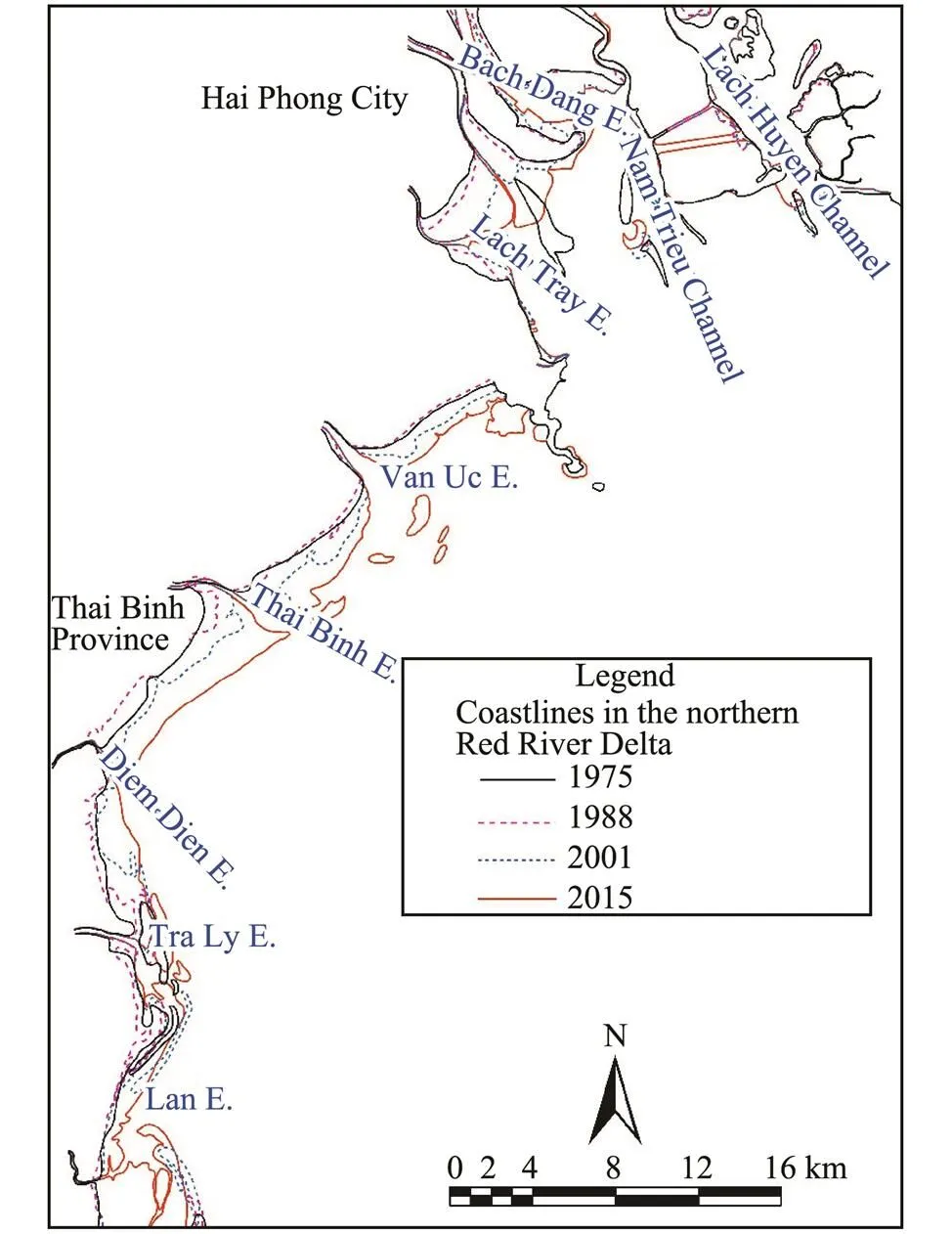
Fig.2 Variations in coastline positions extracted from Land- sat data in four different years.
In the northern sector, most of coastlines underwent certain erosion except for those at the estuaries of Bach Dang, Cam and Lach Tray in the period 1975–1988 (Fig.3a). The coastline progradation at these estuaries was accelerated by the construction of Dinh Vu Dam (Fig.1) and other coastal engineering projects in the period 1988– 2015. At the same time, other coastlines in the northern sector had slight accretion at first, but afterward remained almost stable (Figs.3b, c). In total, a contrasting coastline changing pattern was clearly shown by rapid accretion at the southwestern part including the three estuaries of Bach Dang, Cam and Lach Tray, versus severe erosion at the northeastern part including the Lach Huyen Estuary, Cat Hai Island, and three shoals (NTS, HCS, HDS) in the period 1975–2015 (Fig.3d). A maximum annual average prograding (erosion) rate was up to 28.9 myr−1(33.2myr−1).
In the central sector, most of coastlines underwent slight erosion except for a few tidal flats within or near the two estuaries of Van Uc and Thai Binh, having slight accretion in the period 1975–1988 (Fig.4a). However, almost all these coastlines had changed into accretion in the following period 1988–2015 (Figs.4b, c). In total, the coastlines along the central sector had prograded seaward with annual average rates of 10 to 30myr−1(Fig.4d).
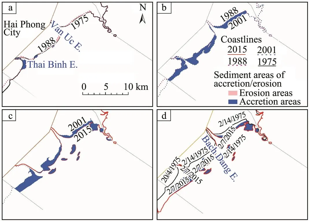
Fig.4 Erosion and accretion patterns in the central sector deciphered by the comparison of coastline positions in the different years of 1975, 1988, 2001 and 2015.
Fig.5 Erosion and accretion patterns in the southern sector deciphered by the comparison of coastline positions in the different years of 1975, 1988, 2001 and 2015.
Coastline erosion and accretion patterns in the southern sector were quite similar to those of the central sector, changing from almost entire erosion in the period 1975– 1988 to entire accretion in the following period 1988– 2015 (Figs.4, 5). Rapid accretion was typically evident at the southwestern corner of the sector behind the barrier islands (Fig.5). In total, net rapid accretion was observed from 1975 to 2015, except for some locations where erosion was produced by channel shifting and alongshore bars migration (Fig.5d). Annual average coastline prograding rates were several meters to tens of meters per year with a maximum rate of 104.6myr−1at the southern coast of Lan Estuary.
4.2 Morphological Variations in the Northern RRD
Morphological change in the subaqueous delta was analyzed by the comparison of bathymetrical data digitized from nautical charts in the three decades: 1960s, 1990s and 2000s (Table 1). According to morphodynamic features, the northern RRD is further subdivided into three sectors with their boundaries at Hon Dau Island and Thai Binh Estuary, respectively (Fig.1). Their respective morphological change will be separately described below.
4.2.1 Northern sector
The northern sector, from Lach Huyen channel to Do Son Peninsula, is also known as the Bach Dang Estuary area (Thanh, 1993; Huy, 1996; Vuong., 2016). It is featured by some linear shoals,., Lach Tray Shoal (LTS), Nam Trieu Shoal (NTS), Hang Day Shoal (HDS), and Hoang Chau Shoal (HCS), dissected by distributary channels or tidal channels,., Lach Tray Channel (LTC), Cam Channel (CC), Nam Trieu Channel (NTC), and Lach Huyen Channel (LHC). The most marked morphological change is related to the construction of Dinh Vu Dam at the Cam River, and Dike 14 for land reclamation during 1979–1981 (Fig.6). After the dam construction, siltation in the Cam channel and accretion on the adjacent intertidal flats were highly promoted, and the coastline moved seaward rapidly (Figs.6, 7). Nam Trieu Shoal (NTS) was also highly influenced by this engineering project and the NTC behavior. It was cut shorter due to land reclamation, and shifted southward roughly 3000m due to NTC movement from the 1960s to the 1990s (Transect N-02 in Fig.7). The NTS topography almost remained the same size from the 1990s to the 2000s, but erosion should have occurred at least at the summit of NTS where the area above 0m was clear in the 1990s but vanished in the 2000s (Fig.6).
Siltation in the NTC and LHC is another obvious morphological change in the northern sector (Fig.6). The NTC was principally >10m deep and 1800m wide in the 1960s, being important waterway to the Hai Phong Port. However, the NTC underwent significant siltation after the construction of Dinh Vu Dam, and the mainchannel depth and width decreased to 5m and 1000m in the 1990s, respectively. The siltation caused big trouble for big ships to enter the Hai Phone Port, even though the mainchannel depth increased slightly to 8m in the 2000s (Transect N- 01 in Fig.7). The LHC was less influenced by coastal engineering, maintaining a relatively better navigational condition, but it was separated from the main waterway by the Cat Hai Island.
Therefore, the municipal government of Hai Phong made a decision to dig a canal, namely Cai Trap Channel (CTC in Fig.6c), to connect these two waterways. However, a poor design made the CTC become a major sink of fluvial sediments. Siltation and overloading in the CTC promoted the government to dig another canal, namely Nam Trieu Channel (NTC), in the early 2000s. However, another distributary channel at the southern corner of the sector, namely LTC, had not changed significantly in the period 1960s–2000s, merely with its main channel shifting southward slightly (Fig.6).

Fig.6 Reconstructed DEM maps showing major topographic features in the coast of the northern sector of northern RRD in the 1960s (a), 1990s (b) and 2000s (c). Full expressions of the acronyms can be found in the context, and water depths in this paper are all referred to the lowest astronomical tidal level at the Hon Dau tidal gauging station (known as Hon Dau Datum, HD).
There are two shoals (HDS and HCS) at the eastern side of the Cat Hai Island, and their shapes were significantly influenced by the evolution of NTC and LHC (Fig.6, Transect N-02 and N-03 in Fig.7). The two shoals were clearly defined by the 2-m isobaths in the 1960s, but the accretion at the middle ground between the two shoals turned to unite them together since the 1990s. At the same time, the length of HCS grew remarkably shorter as shown by the 2-m isobaths in the DEM map of the 2000s. Erosion should have occurred significantly at the outer part of shoals and subtidal platforms, as shown by the landward movement of the 5-m isobaths, which stretched deeply into the NTC to reach almost its inside counterpart in the 2000s (Fig.6c). The similar pattern was also clearly shown along the three crossshore transects (N04–06) by the terms of erosion at the outer part of the transects versus deposition at the inner part, with a transitional boundary roughly at the 2-m isobath (Fig.7).
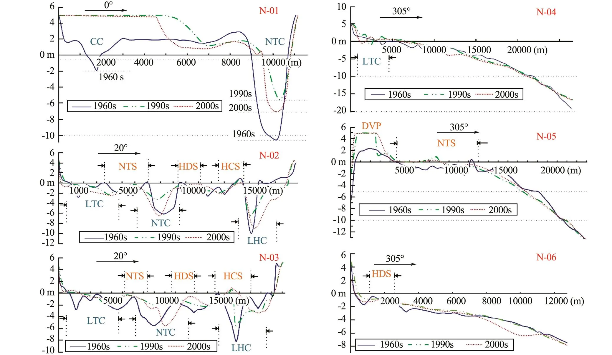
Fig.7 Alongshore (N01–03) and crossshore transects (N04–06) showing morphological variations in the periods between the 1960s, 1990s and 2000s in the northern sector of northern RRD.
4.2.2 Middle sector
The middle sector is located between Do Son Peninsula and the northern Thai Thuy coast (Fig.1), where the two river mouths of Van Uc and Thai Binh have evolved from estuary into delta with protruding coastal configurations (Tiep, 1993; Huy, 1996). This sector is characterized by very rapid accretion on intertidal flats (above 0-m isobaths), typically in the period between the 1960s and 1990s (Figs.8, 9). The width of intertidal flats neighbouring the Do Son peninsula was roughly 1500m from the seawall to the 0-m isobath in the 1960s, and increased rapidly up to 5000m in the 1990s. Since then, the growth seemed to be frozen abruptly as shown by an approximate superposition of two cross-shore profiles in the 1990s and 2000s (Transect M-01 in Fig.9).
Accretion also occurred very fast on Tien Lang intertidal flats between Van Uc and Thai Binh estuaries in the period from the 1960s to 1990s with its width increasing roughly from 1200m to 8000m, but it was followed by a stagnant period as shown by slight change in cross-shore profiles between the 1990s to 2000s (Transect M-02 in Fig.9). In comparison, the intertidal flats, south of the Thai Binh Estuary, enlarged in a moderate rate from a width of 2500m in the 1960s to 4200m in the 1990s, while a slight erosion occurred across intertidal and subtidal flats in the period between the 1990s and 2000s (Transect M-03 in Fig.9).

Fig.8 Reconstructed DEM maps showing major topographic features in the coast of the middle sector of northern RRD in the 1960s (a), 1990s (b) and 2000s (c). Full expressions of the acronyms are given in the corresponding context.
There are five shoals in this sector, including the Southwest Do Son Peninsula Shoal (SWDSPS), North Van Uc Shoal (NVUS), South Van Uc Shoal (SVUS), North Thai Binh Shoal (NTBS) and South Thai Binh Shoal (STBS) (Figs.8, 9). These shoals underwent rapid accretion as the intertidal flats in the period 1960s–1990s, but the growth slowed down obviously or even turned into slight erosion in the period between the 1990s and 2000s. There was a branch of Van Uc channel (BVUC) flowing through the NVUS towards the SWDSPS in the 1960s, but continuous siltation made it disappear in the 1990s, leading to NVUS and SWDSPS amalgamation into a united one. At the sametime, the main Van Uc Channel (MVUC) had got shallower by 2 to 3m, and shifted northeastward. Rapid siltation also occurred in the Thai Binh channel (TBC) with a magnitude of 3–4m between the 1960s and 1990s, and shifted southwestward. However, both MVUC and TBC turned to be stable in the 2000s (Fig.8, Transect M-04 in Fig.9).
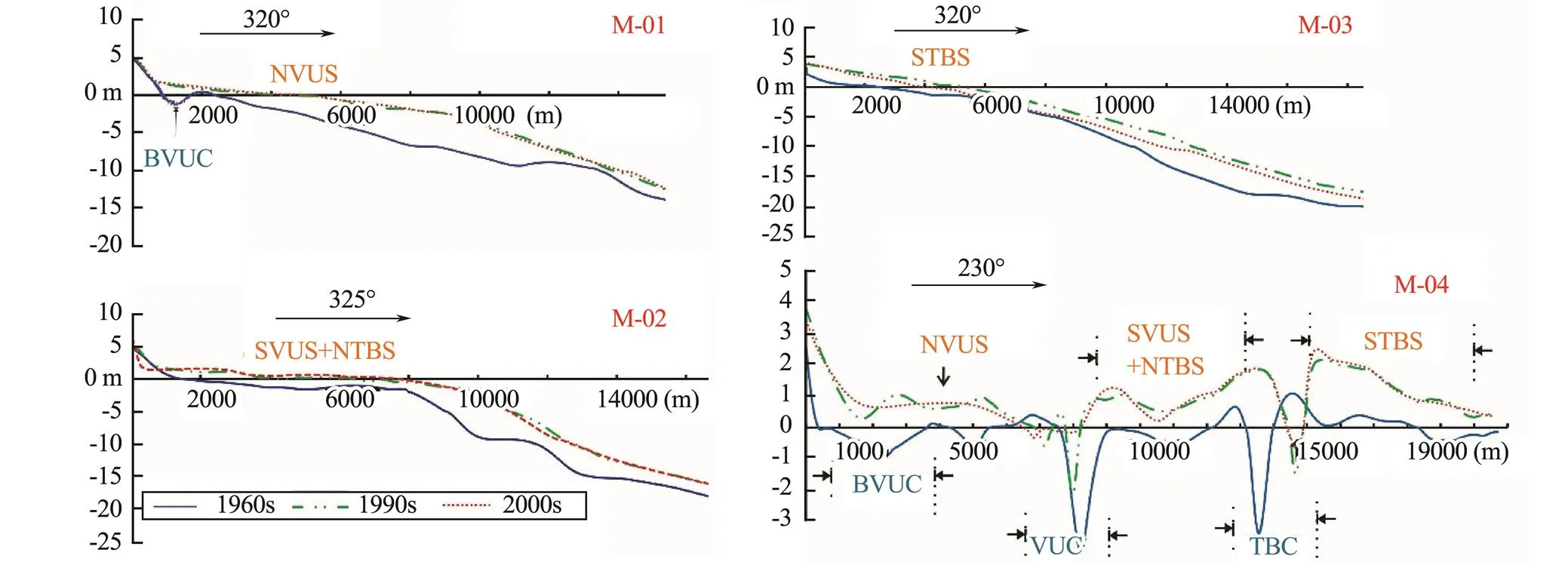
Fig.9 Crossshore (M-01 to 03) and alongshore transects (M-04) showing morphological variations in the periods between the 1960s, 1990s, and 2000s in the middle sector of the northern RRD.
4.2.3 Southern sector
The southern sector is located between the northern Thai Thuy coast and the Lan Estuary, featured by fluvial dominance with increasing wave action (Tiep, 1993). Most of tidal flats were observed to undergo rapid accretion in the period 1960s–1990s, and then accretion slowed down sharply or even turned into erosion at some locations during the period 1990s–2000s (Figs.10, 11). The width of the northern Diem Dien intertidal flat (NDDTF) changed from 3500m in the 1960s to 6500m in the 1990s. Although the intertidal width kept almost the same, the surface had been significantly lowered, with a maximum erosion magnitude of >1m, in the period 1990s–2000s(Transect S-01 in Fig.11). Acrection on the Diem Dien- Tra Ly tidal flats (DD-TLTF) was relatively minor from the 1960s to 2000s, and accretion majorly occurred near the lower spring tidal line (Transect S-02 in Fig.11). On the Tra Ly-Lan tidal flat (TL-LTF), its intertidal width in- creased rapidly from 1000m in the 1960s to 3500m in the 1990s, but remained almost the same in the period 1990s– 2000s (Transect M-03 in Fig.11). The development of Lan tidal flats (LTF) was obviously influenced by the northward shifting of Lan Channel (LC) to produce severe erosion in the period 1960s–1990s, but it turned into rapid accretion soon after the LC became stable in the 2000s and the intertidal width recovered to 6000m (Tran- sect S-04 in Fig.11).

Fig.10 Reconstructed DEM maps showing major topographic features in the coast of the southern sector of northern RRD in the 1960s (a), 1990s (b) and 2000s (c). Full expressions of the acronyms are given in the corresponding context.
This sector receives three distributary rivers (., Diem Dien, Tray Ly and Lan) flowing into the sea, and their sub- aqueous channels underwent complex variations in the study periods (Fig.10). Their evolution history was examined in detail along the Transect S-05 in Fig.11. The location that accommodated the Diem Dien channel (DDC) in terms of 5m deep and 600m wide in the 1960s, was silted rapidly to become a part of tidal flats with an elevation reaching 0m in the 1990s and then 2m high in the 2000s when the channel shifted 1000m southward. Along the tran- sect S-05, Tra Ly Channel (TLC) was merely 0.5m deep and 50m wide in the 1960s, remained almost the same in the 1990s, but grew slightly deeper and wider in the 2000s as it shifted northward. Lan Channel (LC) was roughly 3m deep and 10000m wide along the transect S-05 in the 1960s, decreased to 1.5m deep and 3000m wide in the 1990s because of siltation, and turned into a part of intertidal flat as LC continued northward shifting (Transect S- 05 in Fig.11).
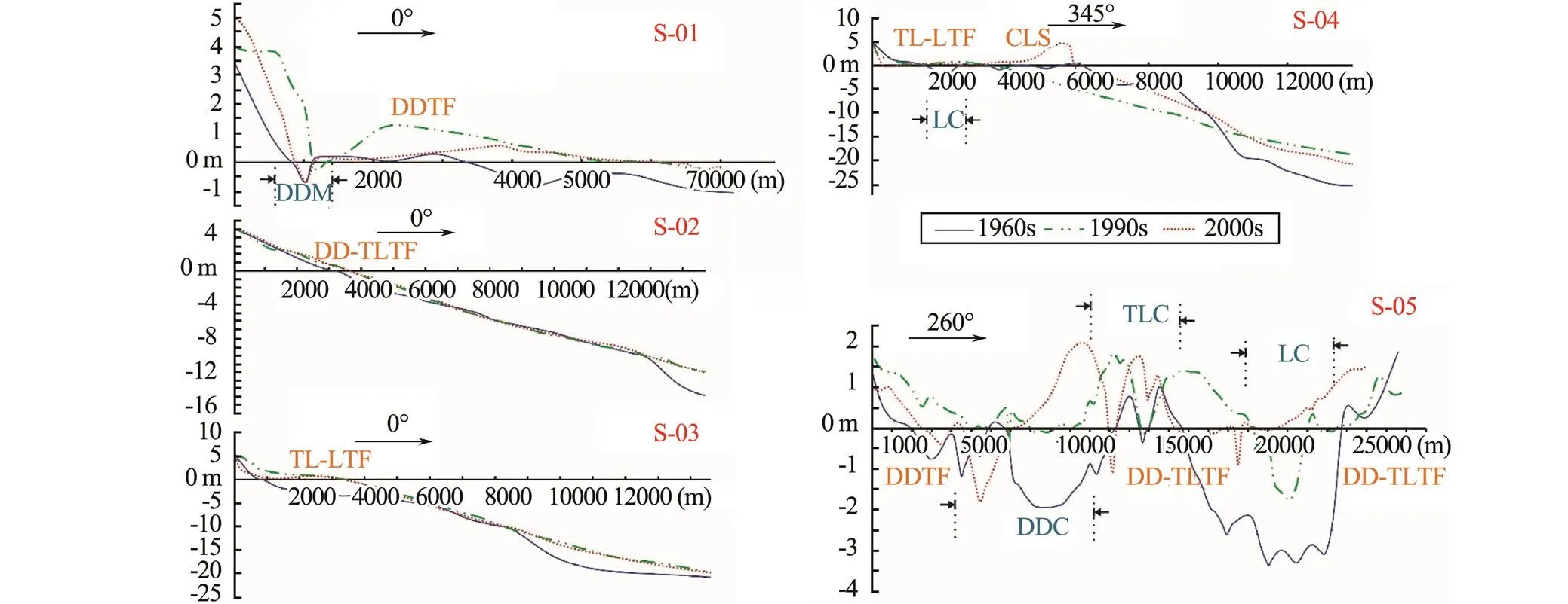
Fig.11 Crossshore (S-01 to 04) and alongshore transects (S-05) showing morphological variations in the periods between the 1960s and 2000s in the southern sector of northern RRD.
5 Discussion and Conclusions
Long-term coastal evolution in the northern RRD was analyzed by the comparison study of DEM data digitized from bathymetrical maps spanning from 1965 to 2004, and mean high-tide-line positions from Landsat images in the period 1975–2015. Most of study coasts underwent net accretion over the last few decades except for Cat Ba and Cat Hai islands at the northeastern corner (Figs.1–3). Coastline prograding rates were not found to change significantly after the completeness of Hoa Binh Dam (HBD) in 1988, which has been accused for a sharp drop of yearly suspended sediment flux at Son Tay station near Hanoi from 119Mtyr−1(1960–1979) to 46Mtyr−1(1989– 2010) (Vinh., 2014). On the contrary, extensive coastline recession occurred during the period 1975–1988 before the dam completeness, which should be linked with decadal wind-wave or storm activities instead of sediment deficiency. In the last two decades, rapid accretion was also reported to occur at the two major river mouths of Ba Lat and Day in the southern RRD (Fig.1). It is therefore indicated that there is a lag response of coastal erosion to sharp decrease in sediment flux in the RRD, typically in its northern part with a tidal dominance. Similar phenomenon was also reported in the Yangtze Delta where nearshore accretion continues progradation after the operation of Three-Gorges Reservoir in 2003 (Chu., 2013; Fan., 2017; Xie., 2017).
Comparison studies on crossshore profiles over different decades demonstrated that significant accretion had occurred not only at intertidal flats but also at subtidal shoals and platforms during the period 1960s–1990s. Rapid accretion continued at intertidal flats and the inner part of subtidal shoals and platforms in the period 1990s–2000s, but their outer parts had little accretion or even turned into remarkable erosion (Figs.7, 9, 11). The similar pattern has been reported in the Yangtze Delta, where erosion at the outer coastal zone was considered to respond to sharp decrease in sediment discharge from the river after the Three-Gorges Dam, and part of resuspended sediments could be transported landward by strong tidal currents to maintain accretion at the inner coastal zone (Fan., 2017). Therefore, this tidal pumping action was considered to account for morphodynamic change in the northern RRD after the completeness of HBD. While, the difference was also evident at the transition line between inner accretion and outer erosion zones, which was located at 2–5-m isobaths in the norther RRD having a steep delta front5–10-m isobaths in the Yangtze Delta with a relatively gentle deltafront profile.
There should have a time limit for a lag effect of coastline recession in response to sediment deficiency in a tide- dominated delta. Several factors will further cut shorter this time limit. For example, more dams will be constructed in the upstream reaches of Red River. Relative sea-level rise is 1.9mmyr−1 in the RRD according to long-term tidal gauging data (Duc., 2012). Warming ocean may trigger more and stronger typhoons to strike the coast. Land reclamation and other poor-designed coastal engineering projects may worsen the coastal erosion, and then expose coastal community to higher risk of marine and geological disasters (Thanh., 2004; Duc., 2012). Therefore, these adverse effects should be fully considered in coastal planning and management.
Acknowledgements
This research was funded by the National Natural Science Foundation of China (Nos. 41776052, 41476031), the Joint Research Project Between China and Vietnam (NDT.01.CHN/15), and the China-ASEAN maritime cooperation fund ‘Comparative Study of Holocene Sedimentary Evolution of the Yangtze River Delta and the Red River Delta’. We are grateful to the two anonymous reviewers for their constructive suggestions to improve the previous version.
Anthony, E. J., Brunier, G., Besset, M., Goichot, M., Dussouillez, P., and Nguyen, V. L., 2015. Linking rapid erosion of the Mekong River Delta to human activities., 5:14745, DOI: 10.1038/srep14745.
Chu, Z., Yang, X., Feng, X., Fan, D., Li, Y., Shen, X., and Miao, A., 2013. Temporal and spatial changes in coastline movement of the Yangtze delta during 1974–2010., 66: 166-174.
Claire, C., Viet, P. B., Nhung, P. T. N., Phung, H. P., and Lam, N. D., 2012. Remote sensing application for coastline detection in Ca Mau, Mekong Delta.. Ho Chi Minh, Viet- nam, 199-204.
Duc, D. M., Nhuan, M. T., Ngoi, C. V., Nghi, T., Tien, D. M., van Weering, Tj. C. E., and van den Bergh, G. D., 2007. Sediment distribution and transport at the nearshore zone of the Red River Delta, northern Vietnam., 29 (4): 565-588.
Duc, D. M., Nhuan, M. T., and Ngoi, C. V., 2012. An analysis of coastal erosion in the tropical rapid accretion delta of the Red River, Vietnam., 43: 98-109.
Fan, D., Wu, Y., Zhang, Y., Burr, G., Huo, M., and Li, J., 2017. South Flank of the Yangtze Delta: Past, present, and future., 392: 78-93.
Fang, G., Kwok, Y. K., Yu, K., and Zhu, Y., 1999. Numerical simulation of principal tidal constituents in the South China Sea, Gulf of Tonkin and Gulf of Thailand., 19 (7): 845-869.
Ha, D. T., Coynel, A., Orange, D., Blanc, G., Etcheber, H., and Le, L. A., 2010. Long term monitoring (1960–2008) of the river-sediment transport in the Red River Watershed (Vietnam): Tempal variability and dam-reservoir impact., 408: 4654-4664.
Hori, K., Tanabe, S., Saito, Y., Haruyama, S., Nguyen, V., and Kitamura, A., 2004. Delta initiation and Holocene sea-level change: Example from the Song Hong (Red River) Delta, Vietnam., 164: 237-249.
Huy, D. V., 1996. Modern morph-dynamics in coastal zone of Hai Phong. PhD thesis. Hanoi National University, 127pp.
Li, C., Fan, D., Deng, B., and Korotaev, V., 2004. The coast of China and issues of sea level rise., 43: 35-49.
Mathers, S. J., Davies, J., McDonald, A., Zalasiewicz, J. A., and Marsh, S., 1996. The Red River Delta of Vietnam., 41pp.
Milliman, J. D., and Meade, R. H., 1983. World-wide delivery of river sediment to the oceans., 91: 1-21.
Saito, Y., Chaimanee, N., Jarupongsakul, T., and Syvitski, J. P. M., 2007. Shrinking megadeltas in Asia: Sea-level rise and sediment reduction impacts from case study of the Chao Phraya Delta., 2: 3-9.
Stanley, D. J., and Warne, A. G., 1994. Worldwide initiation of Holocene marine deltas by deceleration of sea level rise., 265: 228-231.
Stanley, D. J., and Warne, A. G., 1997. Holocene sea-level change and early human utilization of deltas., 7 (12): 1-7.
Syvitski, J. P. M., and Saito, Y., 2007. Morph-dynamics of deltas under the influence of humans., 57: 261-282.
Syvitski, J. P. M., Kettner, A. J., Overeem, I., Hutton, E. W., Hannon, M. T., Brakenridge, G. R., Day, J., Vörösmarty, C., Saito, Y., Giosan, L., and Nicholls, R. J., 2009. Sinking deltas due to human activities., 2: 681-686.
Thanh, T. D., 1993. Holocene evolution of the Bach Dang Estuary. PhD thesis. Hanoi National University.
Thanh, T. D., Saito, Y., Huy, D. V., Lap, N. V., and Oanh, T. T. K., 2004. Regimes of human and climate impacts on coastal changes in Vietnam., 4: 49- 62.
Tiep, N. T., 1993. Modern morph-dynamics in coastal zone of Red River Delta. PhD thesis. Hanoi National University.
van Maren, D. S., 2004. Morphodynamics of a cyclis prograding delta: The Red River, Vietnam. PhD thesis. Utrecht University.
Vinh, V. D., Ouillon, S., Thanh, T. D., and Chu, L. V., 2014. Impact of the Hoa Binh dam (Vietnam) on water and sediment budgets in the Red River Basin and Delta., 18: 3978-4005.
Vinh, V. D., Thanh, T. D., Binh, D. T., and Saito, Y., 2009. Coastal accretion and erosion in the Red River Delta and the influence of monsoon., 1: 108-124.
Wang, H., Saito, Y., Zhang, Y., Bi, N., Sun, X., and Yang, Z., 2011. Recent changes of sediment flux to the western Pacific Ocean from major rivers in East and Southeast Asia., 108: 80-100.
Xie, D., Pan, C., Wu, X., Gao, S., and Wang, Z. B., 2017. Local human activities overwhelm decreased sediment supply from the Changjiang River: Continued rapid accumulation in the Hangzhou Bay-Qiantang Estuary system., 292: 66-77.
December 22, 2017;
April 15, 2018;
May 18, 2018
© Ocean University of China, Science Press and Springer-Verlag GmbH Germany 2018
. Tel: 0086-21-65989073E-mail: ddfan@tongji.edu.cn
(Edited by Chen Wenwen)
杂志排行
Journal of Ocean University of China的其它文章
- Comparative Evaluation of Toleration to Heating and Hypoxia of Three Kinds of Salmonids
- Internal Facies Architecture and Evolution History of Changxing Mouth-Bar Complex in the Changjiang (Yangtze) Delta, China
- The Holocene Environmental Evolution of the Inner Hangzhou Bay and Its Significance
- Provenance of Sediments Filling a Paleo-Channel that Formed on the Western Yellow Sea Continental Shelf During the Last Glacial Period
- Distribution and Characteristics of Hazardous Geological Features in the Marine Coastal and Offshore Areas of Zhejiang Province, East China Sea
- Characteristics of Heavy Minerals and Quantitative Provenance Identification of Sediments from the Muddy Area Outside the Oujiang Estuary Since 5.8 kyr
