Meteorological observations and weather forecasting services of the CHINARE
2018-12-20SUNQizhenZHANGLinMENGShangSHENHuiDINGZhuomingZHANGZhanhai
SUN Qizhen, ZHANG Lin, MENG Shang, SHEN Hui, DING Zhuoming & ZHANG Zhanhai
1 Polar Environmental Research and Forecasting Division, National Marine Environmental Forecasting Center, Beijing 100081, China;
2 Physical Oceanography Laboratory, Ocean University of China, Qingdao 266100, China;
3 SOA Key Laboratory for Polar Science, Polar Research Institute of China, Shanghai 200136, China
Abstract By 2018, China had conducted 34scientific explorations in Antarctica spearheaded by the Chinese National Antarctic Research Expedition (CHINARE). Since the first CHINARE over 30 years ago, considerable work has been undertaken to promote the development of techniques for the observation of surface and upper-air meteorological elements, and satellite image and data reception systems at Chinese Antarctic stations and onboard Chinese icebreakers have played critical roles in this endeavor. The upgrade of in situ and remote sensing measurement methods and the improvement of weather forecasting skill have enabled forecasters to achieve reliable on-site weather forecasting for the CHINARE. Nowadays, the routing of icebreakers, navigation of aircraft, and activities at Chinese Antarctic stations all benefit from the accurate weather forecasting service. In this paper, a review of the conventional meteorological measurement and operational weather forecasting services of the CHINARE is presented.
Keywords Chinese National Antarctic Research Expedition (CHINARE), meteorological observations, weather forecasting services
1 Introduction**
The weather and climate in Antarctica have considerable influence on the global climate. It has been over 30 years since the first Chinese National Antarctic Research Expedition (CHINARE). During these years, meteorological observations and weather forecasts along the routes of vessels/icebreakers and at Chinese Antarctic stations have provided strong support for the CHINARE. Meanwhile,Chinese Antarctic operational meteorological observations and weather forecasting services have also made considerable progress.
According to the assignment of the State Oceanic Administration (SOA) of China, it is the duty of the National Marine Environmental Forecasting Center(NMEFC), which is an agency of the SOA, to provide operational weather forecasting services for vessels/icebreakers, Chinese Antarctic stations, and helicopter and fixed-wing aircraft activities over polar areas. Historically,the meteorologists of the NMEFC and other institutes have studied various fields of Antarctic weather and climate,which are widely considered fundamental components of global warming and climate change. Such research has focused on the climate characteristics and special weather phenomena at Chinese Antarctic stations, as well as the development of weather forecasting technology for application in Antarctica and the Southern Ocean region.This research work has profoundly benefitted weather forecasting services for the CHINARE.
As for operational meteorological measurements, the NMEFC began to focus on Southern Ocean meteorological observations in 1984, which included continuous surface meteorological measurements and radiosonde launches onboard marine vessels. The Chinese Academy of Meteorological Sciences of the China Meteorological Administration has been performing in situ observations at Chinese Antarctic stations following the standards of the World Meteorological Organization (WMO). The China Meteorological Administration and the SOA run separate operations with different numerical models for different regions: the NMEFC of the SOA for the Antarctic and the National Meteorological Center of the China Meteorological Administration for domestic China. The NMEFC acquires satellite observations and performs interpretations for Chinese Antarctic stations, while the National Meteorological Center performs similar work for domestic China.
This paper, which comprises a review and summary of the meteorological observation and forecasting services of the CHINARE, is organized as follows. Section 2 introduces the methods used for meteorological observations during CHINARE cruises and at the Antarctic Great Wall and Zhongshan stations. Section 3 describes the historical evolution of the weather forecasting service.Finally, our conclusions are presented in Section 4.
2 Meteorological observations
Meteorological investigation is one of the most important tasks of Chinese Antarctic research activities. It is essential to understand the local weather and climate prior to the establishment of all-year-round Antarctic research stations.Moreover, long-term records of Antarctic meteorological measurements are critical to the study of global atmospheric circulation and climate change (Lu et al., 2011a, 2011b;Bian et al., 1988; Chen, 1985).
2.1 Observations during cruises
Weather forecasting services are vital during icebreaker cruises between mainland China and Antarctica, especially in the region of the westerlies that circulate around the continent, which create harsh ocean conditions for the passage of marine vessels. Real-time observations of local weather are essential for producing reliable weather forecast to aid maritime navigation. The meteorological surface measurements obtained onboard the icebreakers help weather forecasters make precise judgments regarding the short-term evolution of regional weather systems that could affect the vessels. In addition,icebreaker cruises provide valuable opportunities for scientific investigation of the metrological conditions along their routes in various oceans.
In 1984, when the first CHINARE was conducted, the voyage of the R/V Xiangyanghong-10 included a meteorological service team of about 30 members. The team consisted of several groups with different tasks, e.g.,meteorological observation, chart plotting, satellite image reception, and weather forecasting. At that time, routine meteorological observation records were mainly made manually because the sensors onboard were not electronic.The records were then used to draw weather charts and to provide weather forecasting services for the navigation of the vessel and the expedition members who were working ashore. Some years later, meteorological observation technology underwent substantial development. Automatic measurement and charting equipment were introduced to replace outdated technology. In 1999, a Finnish Vaisala automatic weather station (AWS) was deployed onboard the R/V Xuelong icebreaker, which triggered a new era of meteorological observation because certain variables could be measured without human interference. In 2004, a turbulent flux measurement system was installed on the R/V Xuelong to observe momentum flux during its cruises. This system was also capable of recording sea surface temperature. The original Vaisala AWS functioned for about 18 CHINARE voyages to the Arctic and to Antarctica before it was replaced in 2013 by an American Campbell AWS.
Nowadays, horizontal visibility and the height of the cloud base can be measured automatically on icebreakers,in addition to many other routine surface elements, e.g., air temperature, pressure, wind, humidity, and precipitation.Furthermore, it is also possible to record sea conditions,including wave height, snow on sea ice, and sea ice concentration and thickness. The employment of modern technology makes the acquisition of meteorological measurements easier and the actual data more precise.Currently, three onboard meteorologists are able to manage the entire mission, whereas it used to require a much larger team.
In addition to surface measurements, atmospheric soundings using high-altitude sounding balloons, which incorporate radiosondes manufactured by Chinese companies, constitute another important task undertaken during cruises of Chinese icebreakers. The sounding system onboard the R/V Xuelong is being used to probe the profiles of the atmosphere from the surface up to 20000 m above sea level (ASL). Air temperature, pressure, humidity, and wind speed and direction data at multiple heights are being obtained regularly to facilitate scientific research of the vertical structure and evolution of weather systems.
2.2 Observations at Chinese Antarctic stations
The SOA established the Great Wall weather station on King George Island in 1984 and the Zhongshan weather station in the Larsemann Hills in 1989. At these stations,weather observation systems are operated in accordance with WMO standards for the acquisition of long-term time series data of important meteorological elements. Thanks to the continuous work of the weather observers, who are replaced annually, approximately 30 years’ observational data have been obtained, which constitute a useful resource for research into the climate of coastal areas of Antarctica.However, no routine upper-air observations have been conducted at the Chinese Antarctic stations before now. In addition to weather monitoring systems, an atmospheric composition sampling system has been operated at Zhongshan Station in recent years to provide essential information about ozone, aerosols, and sedimentation of the local air (Lu et al., 1990). Table 1 provides details of the routine observations undertaken at the Chinese Antarctic stations. Note that the CAWS600, Picarro 1301, and TE49i instruments listed in the table are models produced by China and the United States.
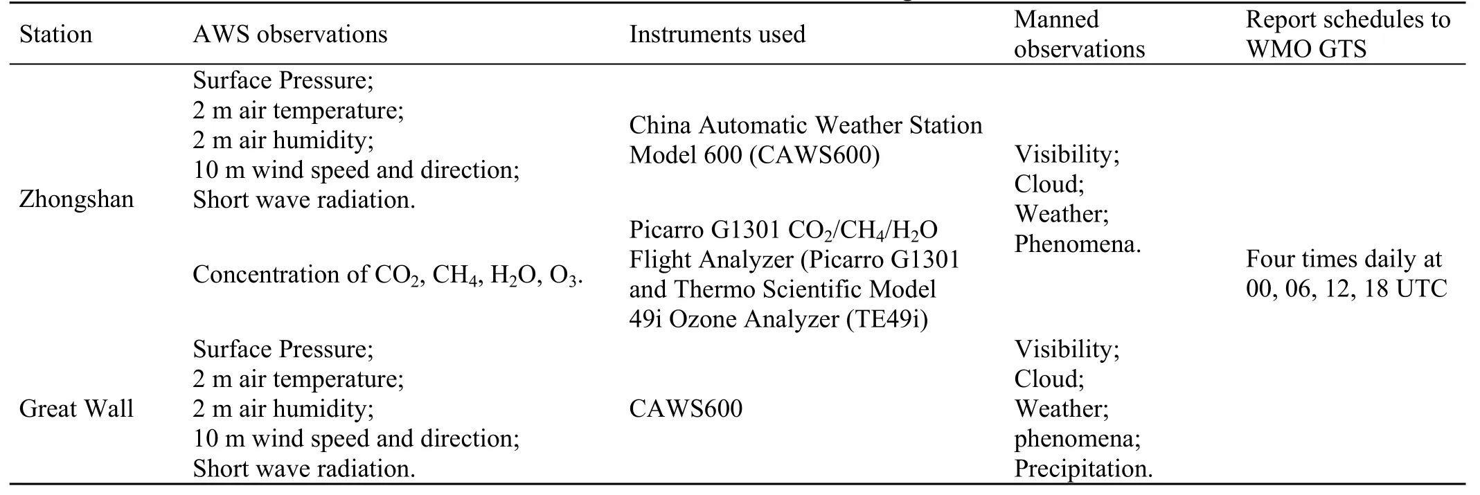
Table 1 Routine observations at China’s Antarctic Zhongshan and Great Wall stations
During the International Polar Year (2007–2008),Chinese Antarctic meteorological activity represented an important part of IPY China Initiative (Lu et al., 2007).Measurements of the baseline atmospheric composition,vertical ozone profile (derived using a Brewer spectrophotometer), and planetary boundary layer and surface meteorological observations were performed at the Great Wall and Zhongshan stations. Large quantities of first-hand scientific data were obtained, which demonstrated the improvement of the Chinese research capability regarding the polar regions and global climate change.
In recent years, China has also established several AWSs on the highest ice sheet of the Antarctic continent.These AWSs transmit near-real-time local temperature,moisture, solar radiation, wind speed, and atmospheric pressure data via communication satellites, and these data provide an important reference for weather and climate research of the Antarctic interior. In collaboration with Australia and the United States, China has established multiple AWSs between the coastal Zhongshan Station and Dome-A on the inland plateau, and in conjunction with the original stations, these AWSs will form a regional climate monitoring system that will fulfill China’s obligation to the international Antarctic research program (Bian et al., 2016;Ma et al., 2011). All the weather stations, including the manned observational stations and the unmanned AWSs,form the hardware system supporting China’s scientific research in the polar region (Lu et al., 2012).
2.3 Meteorological remote sensing
In the early years of the CHINARE, the radar and satellite image receiving system onboard the vessels/icebreakers provided essential information of the rapidly changing weather, and thus, it played an important role in the process of weather forecasting. However, the satellite image receiving system was only able to obtain visible light images and infrared images with low resolution, limiting the effective application of the remote sense resource.
From 1989, the CHINARE began the process of updating the meteorological equipment onboard the vessels/icebreakers and at the Great Wall and Zhongshan stations. Later, in 1997, a domestic high-resolution satellite image receiving system was installed onboard the R/V Xuelong. Multicolor images with high resolution obtained by geostationary and polar-orbiting satellites became available at the Great Wall and Zhongshan stations in 1992 and 1997, respectively. Subsequently, the CHINARE has been able to monitor weather systems and sea ice along the routes of the icebreakers in near real time using the multicolor satellite imagery.
In 2003, the satellite image receiving system on the R/V Xuelong was upgraded to a more sophisticated model with which the weather forecasters onboard were able to produce more accurate weather predictions and to provide sea ice forecasts for the polar seas (Liu et al., 2011).
By the end of 2009, two identical polar-orbit satellite reception systems were established at the Great Wall and Zhongshan stations. These high-performance dual X- and L-band systems, which track, receive, and process data from the NASA Terra and Aqua, NOAA series, and Chinese Fengyun-1 (FY-1) series satellites, became a powerful tool in various research fields including Antarctica weather,snow cover, sea ice, and ecology in the Southern Ocean.During the 32nd CHINARE (from November 2015 to April 2016), the National Satellite Ocean Application Service of the SOA was successful in testing a new polar-orbit satellite reception system onboard the R/V Xuelong and this system currently contributes to the research efforts of the CHINARE program.
Vast quantities of satellite imagery and raw data have been obtained using several generations of satellite reception systems. This massive amount of remote sensing information has enabled Chinese meteorologists to examine the weather and climate of the Antarctic continent and its surrounding ocean from a macro perspective. Application of the systems to the fields of study of Antarctic katabatic winds, snow cover and its albedo, and atmospheric and oceanic numerical models is currently being strongly promoted (Zhang et al., 2012).
3 Weather forecasting services
3.1 Services for icebreakers, Antarctic stations,and aircraft
As the CHINARE program has developed, meteorological support has become increasingly important. The weather forecasting service for Chinese Antarctic stations dates back to 1984. From the beginning, the weather forecasting service was provided by the NMEFC (Lu and Bian, 1998;Zhang, 1996), and the service remains an important duty of the NMEFC. Figure 1 shows a route typical of the R/V Xuelong during the CHINARE.
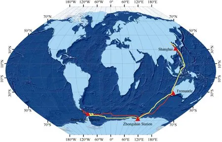
Figure 1 Route typical of the R/V Xuelong during the CHINARE, and the locations of the Chinese Zhongshan and Great Wall stations.Forecast areas cover the regions surrounding the stations and along the route of the icebreaker (red: outward trip; yellow: return trip). Data was derived from http://www.polarscanner.org.
To provide weather predictions that are as accurate as possible, weather forecasters consult surface analysis charts and charts of the geopotential height of pressure surfaces at higher levels that are received onboard the icebreakers. In the early years of the CHINARE, such charts were obtained by fax following dissemination mainly from the Australian Bureau of Meteorology.However, in recent years, the charts have been issued by the NMEFC. Near-real-time satellite images of clouds are also examined before issuing essential predictions regarding the weather systems around the icebreakers(Geng and Cai, 2004; Shi and Jiang, 1994; Zhang and Cai,1994; Qian and Jiang, 1993; Wang, 1993; Xu and Zhai,1993; Han, 1991; Shi, 1989).
The necessity of this service was exemplified during the 26th CHINARE. On 14 October 2009, when the R/V Xuelong was navigating southeastward in the Pacific Ocean,a depression was noted to be strengthening ahead of the vessel. According to the weather forecasters onboard, the depression was predicted to become a tropical cyclone that could have threatened the safety of the icebreaker. Based on the timely and accurate weather forecast, the icebreaker changed its route from southeastward to southward, thereby avoiding the potential risk (Figure 2).

Figure 2 Illustration of how the R/V Xuelong dodged a developing tropical cyclone on its passage across the Pacific Ocean during October 2009.
Real-time observational data from the icebreakers and Antarctic stations are used to reveal the tendency of regional weather systems, which helps the weather forecasting process. However, initially, weather charts were received mainly by fax technology that limited clarity and made it difficult to identify weather systems in certain circumstances. In recent years, weather forecasts used for Chinese icebreaker navigation are disseminated mainly by the NMEFC.
On average, more than 800 cyclones form annually in the Southern Ocean (Wei and Qin, 2016); thus, the threat to the safety of icebreakers is high. During cruises of the 1st,7th, 15th, and 21st CHINAREs, Chinese vessels/icebreakers encountered critical circumstances due to strong winds and high waves attributable to deep cyclones embedded within the westerlies. Based on experience gained in providing navigational support over the past three decades, it has been established that the most critical factor in successful weather forecasting is to identify and track cyclones that could affect the route ahead. In this process, satellite images play an important role in conjunction with numerical weather prediction (NWP) charts.
In addition to severe weather, CHINARE cruises also encounter critical ocean risk. For example, in January 2014,the R/V Xuelong was trapped in Commonwealth Bay(Antarctica) after taking part in the rescue of passengers from the Russian M/V Akademik Shokalskiy. In this area,first-year ice was mixed with multiyear ice, the bay was closed to the continental shelf, and it was surrounded by large icebergs. Continuous strong easterly winds associated with a number of cyclones caused the sea ice to move westward and to accumulate (Wang et al., 2014), which eventually together caused the complexity of the sea ice conditions.
Monitoring of sea ice information and accurate weather forecasting were fundamental to the successful breakout of the vessel (Zhang et al., 2014). As part of the rescue process, the NMEFC made every effort to conduct timely and accurate forecasting of the meteorological and oceanographic conditions. At that time, both an NWP system and a numerical ocean forecasting system were employed. A polar-optimized version of the Weather Research and Forecasting model (Polar WRF) (Bromwich et al., 2013) and the MIT general circulation model(MITgcm) (Campin et al., 2008), which is an ocean model,comprised the cores of the systems. In particular, the time window of strong westerly winds, which eased the intensity of the sea ice conditions considerably and thus was critical in the rescue process, was predicted based on the Polar WRF output (Figure 3). Because of the persistent westerly winds, sea ice within 19 km around the R/V Xuelong fractured, which allowed the vessel to break out. Figure 4 shows the route of the R/V Xuelong during this remarkable event. This particular event highlighted the ability of the NMEFC in dealing with this extraordinary incident of the CHINARE program.
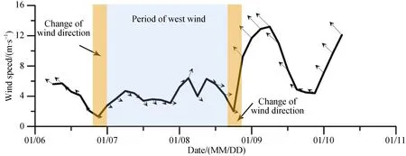
Figure 3 Example products derived from the numerical weather forecasting systems used in the rescue of the M/V Akademik Shokalskiy.
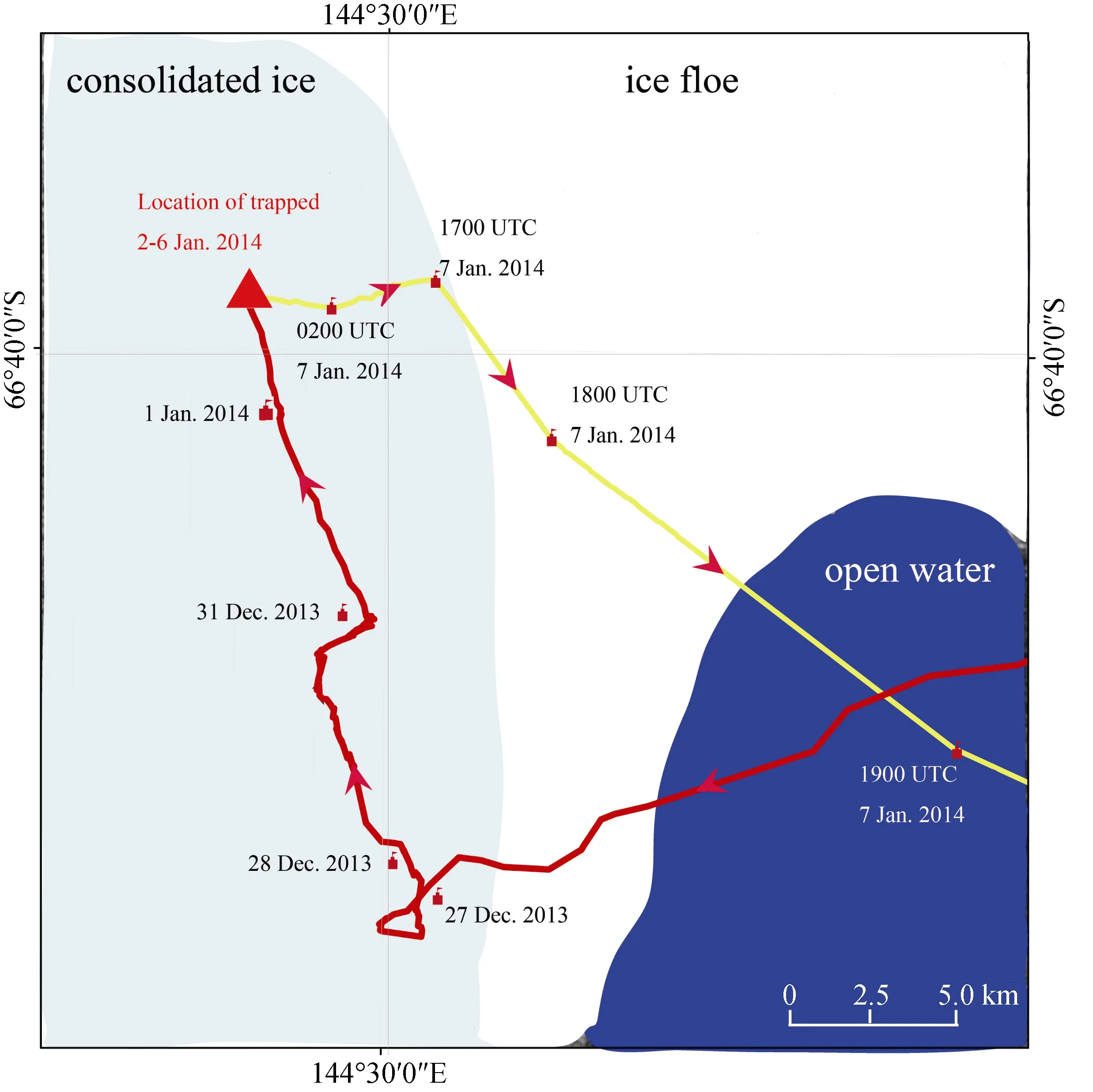
Figure 4 Route of the R/V Xuelong from 27 December 2013 to 7 January 2014 during the remarkable event of the rescue of the M/V Akademik Shokalskiy.
Weather forecasting services have been operational at Chinese Antarctic stations since the first CHINARE era and prediction products are issued at least once daily to provide support for the polar expedition work. In the early years,faxes of weather charts were the main sources of information used for the analysis of the synoptic patterns around the stations. Apart from the limited clarity of the charts, the inevitable delay of their reception also created difficulties in the issuance of timely and accurate weather forecasts.
Over the past 30 years, Chinese meteorologists have undertaken comprehensive research on the weather and climate characteristics around the Chinese Antarctic stations.Unique weather phenomena in Antarctica such as katabatic winds, severe sea fog, and snowstorms have been studied(Sun et al., 2016a; Ding et al., 2015; Xu et al., 2004; Xie et al., 2002; Hu, 1997), and the methods adopted for operational weather forecasting at the stations have been reported (Meng et al., 2015; Yang et al., 2007). These previous studies have proved very important in providing new forecasters a general background understanding of the environment before starting their forecasting work. In recent years, numerical weather charts from various agencies have been employed at the Chinese Antarctic stations. With their comprehensive experience of the local climate, forecasters are able to produce sufficiently accurate weather predictions for up to two days ahead.
China has operated fixed-wing aircraft in Antarctica since 2015. Consequently, the establishment of a more comprehen-sive on-site meteorological observation system for Antarctic airport operations and the improvement of aviation weather forecasting technology are imperative, given the requirements for the security and efficiency of Antarctic flights. However,the geographical condition of the ice highlands is complex and the regional weather systems can change rapidly. Furthermore,the availability of meteorological reference data for flight and airport operations is limited.
Fixed-wing aircraft operations and the associated meteorological services in Antarctica have been undertaken largely by the international community (Sun et al., 2016b).Nevertheless, there are demands for on-site meteorological observation equipment, additional numerical weather forecasting data, and improved aeronautical meteorological forecasting content to support China’s Antarctic fixed-wing aviation activities. In future, the historical weather conditions at the airports and the surrounding areas should be assessed,and a more comprehensive meteorological observation system should be established for the safe operation of China’s Antarctic fixed-wing aircraft. The focus of research should be directed toward katabatic winds, blowing snow, snowstorms,low-level wind shear, and other severe weather phenomena that could represent danger to aviation.
3.2 Development of weather forecasting methods
During the past 10 years, several operational global and regional NWP models have been used as the primary tools for real-time weather forecasts and climate diagnostic studies in Antarctica. Currently, such models have poor skill in simulating the broad-scale circulation and weather systems of Antarctica, partly because of the poor representation of the Antarctic topography and surface features, and inadequate initial conditions resulting from the sparse observational network. However, following recent advancements in the study of the general circulation of the Antarctic atmosphere,improved resolution of the models, and increased volumes of observational data, the skill of Antarctic NWP models has increased in recent years (Sun et al., 2011). For example,recent versions of the Polar WRF are better than earlier Antarctic simulations based on a polar-optimized version of the fifth-generation Penn State/NCAR mesoscale model(Bromwich et al., 2013; Guo et al., 2003)
Prior to July 2011, China’s Antarctic weather forecasts were produced manually. Since 2011, the NMEFC has established an operational polar NWP system,which continuously provides surface and upper-air forecast products with high spatial and temporal resolutions for the polar regions (Sun et al., 2017). The polar NWP system is based on the Polar WRF mesoscale numerical model with proper numerical prediction nested domains and a three-dimensional variational (3D-var)assimilation system (Barker et al., 2012). Validated results have shown that the operational polar NWP system can accurately predict the evolution of short-term polar weather patterns. Within the past six years, in addition to the regular provision of NWP products, the polar NWP system also performed satisfactorily in providing weather forecasting support for several important events. A synopsis of the progress of the development of the NWP system is shown in Table 2. Table 3 presents statistics of forecasts provided by the Polar WRF for the Great Wall station during 1 January to 31 July 2012.

Table 2 Development process of the CHINARE numerical weather prediction system

Table 3 Mean model bias (BIAS), root mean square error (RMSE), and correlation (CORR) statistics of predictions from the Polar WRF, operated by the NMEFC, in comparison with in situ wind speed at 10 m above ground level (WS), surface air temperature (T), and surface air pressure (P) observations at the Great Wall Station during 1 January to 31 July 2012
4 Conclusions
By 2018, China had conducted 34 scientific explorations in Antarctica as part of the CHINARE program, which have realized considerable achievements in the fields of weather observation and forecasting over the past three decades.
Meteorological measurements are critical to the provision of weather forecasting support for the cruises,Antarctic stations, and fieldwork of CHINARE. Therefore,since 1984, considerable work has been done to develop the surface and atmospheric sounding meteorological measurement technology onboard the Chinese vessels/icebreakers. Old equipment has been replaced with modern technology that has enabled automatic and increasingly accurate measurement of meteorological variables. Moreover,large volumes of satellite imagery and raw data have been obtained by several generations of satellite reception systems,both onboard the icebreakers and at China’s Antarctic stations.This massive amount of remote sensing information has enabled Chinese meteorologists to produce weather forecasting products for the Antarctic continent and its surrounding ocean with improved accuracy from a macro perspective. All these developments reflect the remarkable progress achieved by the CHINARE program in the field of meteorological observation.
To conduct reliable weather forecasting activities, Chinese meteorologists have undertaken comprehensive research on the characteristics of the weather and climate along the navigational routes of vessels/icebreakers, and at the Chinese Antarctic stations and their surrounding areas. Unique weather phenomena have been studied in depth and substantial achievements have been accomplished. The ongoing study of weather analysis and forecasting technology has helped increase the accuracy of weather forecast products for the Chinese field stations, navigation of vessels/icebreakers, and aviation operations in Antarctica and the Southern Ocean. Over the previous six years, China’s establishment of an operational NWP system for Antarctica is considered to represent the greatest accomplishment in this field.
In the near future, additional equipment that can monitor real-time weather and receive remote sensing data will be installed in Antarctica. Furthermore, an advanced numerical model will be developed to provide weather forecasting products with improved accuracy. In addition,Chinese meteorologists will continue to devote their efforts to accomplish a more integrated observation system for Antarctic weather, provide more accurate weather forecasting support for the CHINARE program, and achieve greater understanding of the weather and climate of Antarctica and of its impact on global climate change.
AcknowledgmentsWe thank the Editor-in-Chief, also as Guest Editor,Dr. Ian Allison for providing thorough and thoughtful reviews of this paper.This study was supported by the project of National Key R & D Program of China (Grant no. 2016YFC1402705).
Editorial noteThis paper was originally submitted to that Special Issue“Review of CHINARE Progress over the Last Three Decades” (Vol. 28,No 2, 2017).
杂志排行
Advances in Polar Science的其它文章
- Advances in Polar Science CONTENTS (Volume 29, 2018)
- Towards truly integrated modeling and observing of marine ice sheets
- Inviting Contributions to Special Issues in 2019
- Research on governance of HFO use and carriage on ships in accordance with the Polar Code
- An analysis on Sino-Russian cooperation in the Arctic in the BRI era
- Marine protected areas in the Southern Ocean: status and future