东北黑土区农林混合利用坡面土壤水分空间异质性及主控因素
2018-10-11郭欣欣高凤杰杭艳红
郭欣欣,付 强,卢 贺,高凤杰,杭艳红
东北黑土区农林混合利用坡面土壤水分空间异质性及主控因素
郭欣欣1,付 强2※,卢 贺1,高凤杰1,杭艳红1
(1. 东北农业大学资源与环境学院,哈尔滨 150030;2. 东北农业大学水利与土木工程学院,哈尔滨 150030)
针对黑土区坡面尺度上土壤水分在土地利用结构(从坡顶到坡脚,即沿着坡长方向,不同土地利用类型的排列方式)、土地利用类型(农地和林地)及地形要素的协同作用下的空间分异规律及影响机制尚不清楚的现状,以黑龙江省黑土区的农林混合利用典型坡面(克山县)为研究对象,应用植被数量生态学中的冗余分析方法(RDA)分析0~20、20~40、40~60 cm土壤水分剖面变异特征、不同土地利用结构下(农地-农地-农地-农地-农地,农地-农地-林地-林地-农地,农地-农地-林地-林地-林地,林地-林地-农地-林地-农地)坡面土壤水分异质性及其与环境因子的定量关系。结果表明:研究区坡面土壤含水率介于5.77%~45.57%,农地土壤含水率显著高于林地(<0.05),纵向上不同土地利用类型层间土壤含水率差异均不显著;土壤水分呈中等变异,纵向上农地各土层的变异系数(35.9%~39.6%)均高于林地(30.0%~36.5%),农林混合利用加强了土壤水分的空间变异程度;4种土地利用结构下,坡面土壤水分沿坡长方向呈不同的变化趋势,与土地利用镶嵌分布规律有关;冗余分析结果显示土地利用类型是影响黑土区坡面土壤水分异质性的主控因素,坡度次之,坡位和海拔高度对坡面土壤水分异质性也有影响。对于黑龙江黑土区坡面,需要结合土地利用结构配置等土地管理措施与不同的农业措施来防止坡面土壤侵蚀、提高东北区土壤肥力,实现经济效益、生态效益的协调统一。
土壤;水分;土地利用;空间异质性;农林混合结构;坡面;黑土区
0 引 言
黑龙江黑土区作为重要的商品粮基地,在实施千亿斤粮食产能工程及保障国家粮食安全中有不可或缺的作用;而水土流失严重、生态环境退化已成为制约社会经济可持续发展的限制因素。土壤水作为“四水转化”的纽带,不仅是作物生长不可或缺的要素,也是衡量土壤肥力水平的指标之一,同时也是控制土壤侵蚀过程的重要因子[1-4]。因此,研究黑龙江黑土区土壤水分分布规律,对于防治水土流失、提高粮食产量、合理配置土地利用资源均有重要的理论和现实意义。
土壤水分在不同的地点、土壤深度上表现出很明显的空间异质性[5-7],并受控于土壤质地、成土母质、气候条件、地形地貌、土地利用方式和植被覆盖类型等因 素[8-13]。在不同的尺度上,控制土壤水分异质性的因素不尽相同,比如在坡面尺度上,地形要素和土地利用是影响土壤水分异质性的重要因素,且这2类因子中各种要素的协同、叠加影响导致土壤水分异质性更加复杂。因此,坡面尺度下土壤水分异质性机理及其定量表达成为水文土壤学研究的热点及难点[12,14-15]。国内外大量开展坡面土壤水分异质性及主控因素的研究[16-20],这些研究对理解不同区域土壤水分剖面、坡面分异特性及影响机制有重要的意义。然而,以往的研究侧重于不同土地利用类型及地形要素对土壤水分的影响,而对基于坡面不同利用结构(本研究所涉及的土地利用结构是指坡面上从坡顶到坡脚,即沿着坡长方向,不同的土地利用类型的排列方式)、土地利用类型、地形要素协同作用下的分异规律研究较为薄弱,且国内的研究大多集中在黄土区[21-22]、红壤区[23]及喀斯特区[18]。由于研究区域不同,坡面地形条件、土地利用类型及结构、植被覆盖都有区域特性,很多研究结论不尽相同,甚至是相悖的;而黑土区在土壤理化性质、地形要素特征,土地利用状况上与其他地区有显著差异,且坡面土壤水分异质性规律及主控因素并未查清。为此本文选择黑龙江黑土区农林混合利用坡面,研究坡面土壤水分空间异质性特征,并应用植被数量生态学中的冗余分析方法定量揭示影响因子的影响程度,旨在为黑土区优化坡面土地利用结构、推进退耕还林、防治土壤侵蚀及生态重建提供借鉴和参考。
1 研究区概况与研究方法
1.1 研究区域
研究区(48°14¢N,125°50¢E)位于黑龙江省克山县北部(图1a),海拔高度在280~350 m之间,属于黑土区,是全国重要的商品粮基地。该区域属寒温带大陆季风气候,年平均气温为2.4 ℃,年内温差变化大,冬季最冷的1月份,平均气温为-21.5 ℃,夏季最热的7月份,平均气温为22.0 ℃。年平均降水量为500 mm,降水主要集中在6—9月份(可占全年降雨量的80%左右),年平均蒸发量为1 222 mm。
该区地貌类型为丘陵漫岗地貌,以缓坡为主,坡长较长。在同一坡面上,从坡顶到坡脚,土地利用结构复杂,坡面土地利用(主要为坡耕地和乔木林地)呈斑块化镶嵌,人为扰动痕迹明显。土壤类型为黑土,成土母质为第四纪黄黏土。农地无灌溉措施,地下水埋深较深,属“雨养农业”区。研究区突出的生态环境问题为在丘陵漫岗地貌及人为扰动的共同作用导致坡面水土流失严重。
1.2 样地布置及采样
在研究区选择农林混合利用的典型坡面为研究对象(图1b)。采样坡面为阳坡,坡面土地利用结构复杂,坡度在0~5°左右,坡长在1 000~1 600 m之间;土壤砂粒(>0.02 mm)含量为38.26%、粉粒含量(0.02~0.002 mm)为25.15%,黏粒(<0.002 mm)含量为36.59%。
采样方式为线状采样,每条样线按照坡顶(top slope)、坡上(upper slope)、坡中(middle slope)、坡下(lower slope)、坡脚(toe slope)设置5个样点。坡面4种典型的土地利用结构如下:农地-农地-农地-农地-农地(样线号L1,单一结构),农地-农地-林地-林地-农地(L2,坡中易受侵蚀处为林地);农地-农地-林地-林地-林地(L3,半农半林结构);林地-林地-农地-林地-农地(L4,农林间隔配置结构),采样点布设如图1c所示。
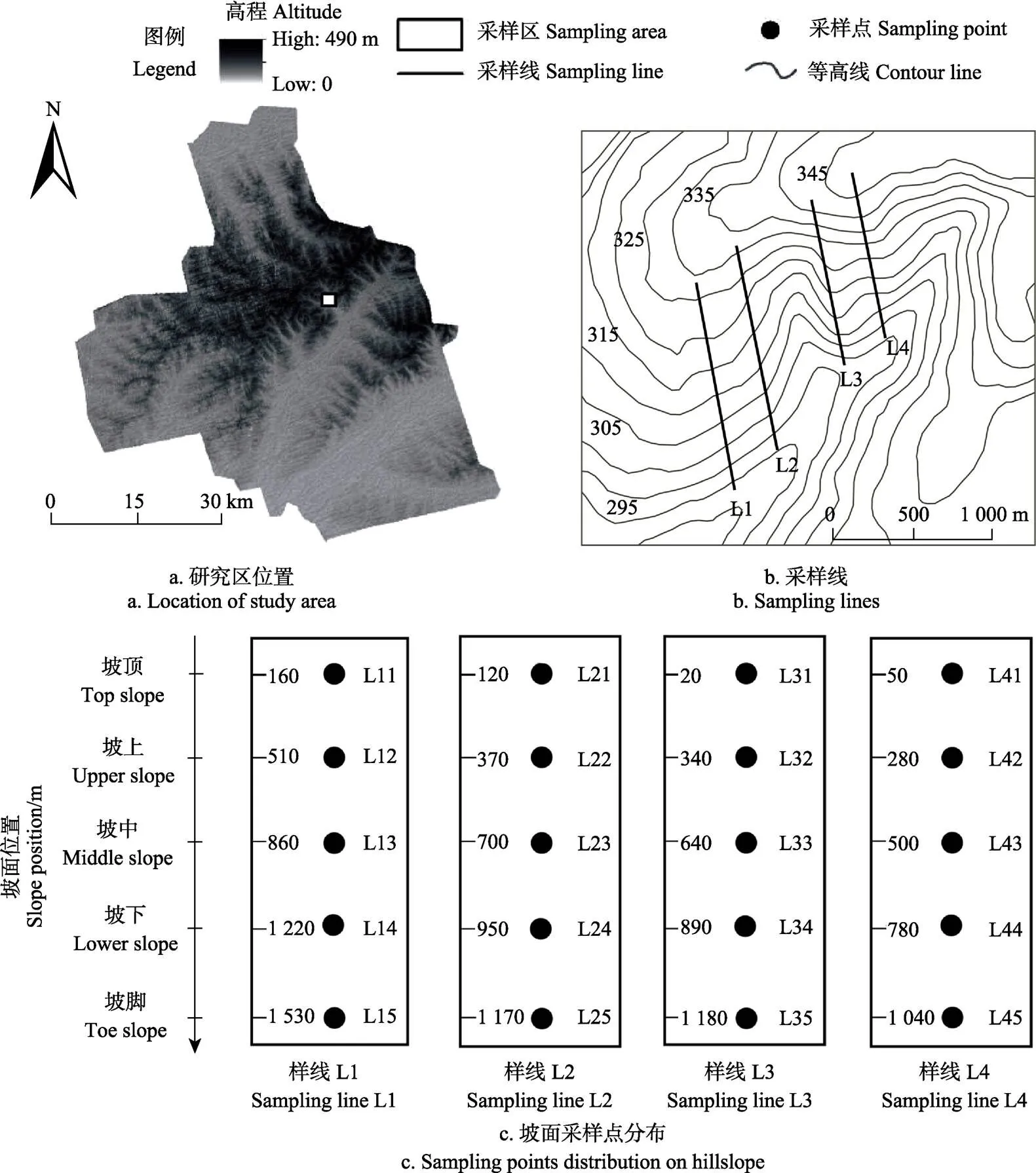
注:图c中数字代表采样点距坡顶端的距离,m。
土壤含水率采用烘干法测定(在105 ℃下烘干24 h)。采样时间为2016年8月中旬到9月中旬,该时段内降雨较为充沛,月中及月末采样(采样间隔约15 d),遇雨延后4 d;整个采样期间,具体采样时间分别为2016年8月15日、8月28日、9月12日,采样时段降雨分布见图2。采样深度60 cm,分3层采样,分别为0~20、20~40、40~60 cm。对于每个样点的每层随机重复3次取样求平均作为该样点该层的土壤含水率。此外,将每个样点所有采样时间各层土壤含水率求平均,该平均值代表该样点土壤含水率,由公式(1)计算获得。每个采样点记录经纬度、海拔、坡度、坡位、土地利用类型等信息,其中,经纬度和海拔高度用便携式GPS(Garmin GPS60)测量,坡度用罗盘测量。采样点的基本信息见表1。

式中i为采样点号;j为土层号;k为采样次数号;Nt为采样的总次数,本研究中为3;Nl为土层总数,本研究中为3;Mi为采样点i的土壤含水率。
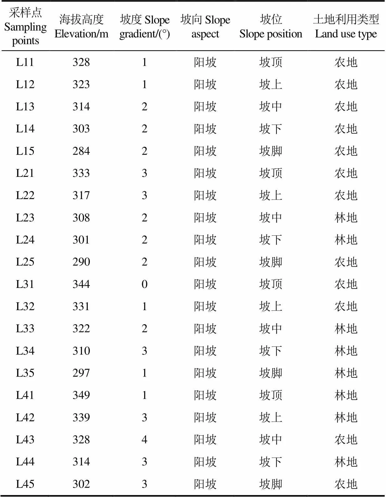
表1 采样点基本信息
1.3 数据处理及分析方法
植被数量生态学中直接梯度分析(约束性排序)因能反映并揭示环境因子与响应变量之间的关系而被广泛应用[24]。直接梯度分析主要包括冗余分析(RDA,线性模型)、典范对应分析(CCA,单峰模型)和去趋势典范对应分析(DCCA,单峰模型)等。在线性模型和单峰模型的选择上,须针对响应变量做“去趋势对应分析(DCA)”,若排序轴的梯度长度的最大值小于3,选择线性模型;大于4,选择单峰模型;数值在两者之间,则2种模型均可[25]。本次研究中选择冗余分析法来提取土壤水分异质性的主控因素,因为DCA分析后排序轴的梯度长度的最大值小于3。分析软件基于CANOCO4.5,选择的环境因子包括海拔高度、坡度、坡位和土地利用类型4个。此外,利用SPSS19.0软件进行经典统计学分析。
2 结果与分析
2.1 土壤含水率统计特征
研究区土壤含水率统计数值如表2所示。在采样期,坡面土壤含水率介于5.77%~45.57%,农地土壤含水率平均值介于20.13%~22.07%,林地土壤含水率平均值介于13.69~15.96%;同一种土地利用方式下,无论是农地还是林地,纵向上随着土层深度的增加土壤含水率的差异均不显著(0.05);而整体上农地含水率显著高于林地含水率(0.05),林木强烈的蒸腾作用可能是导致林地土壤含水率较低的重要原因。从变异系数(CV)上来看,研究区土壤含水率的变异系数均为中等变异(10%CV≤100%)。纵向上农地各层的变异系数(35.9%~39.6%)均高于林地的变异系数(30.0%~36.5%)。整个研究区的变异系数(0~20、20~40、40~60 cm)高于农地、林地等单一土地利用类型下同一深度的变异系数,这说明坡面农林混用下,土地利用类型的多样化是土壤水分变异的重要影响因素。
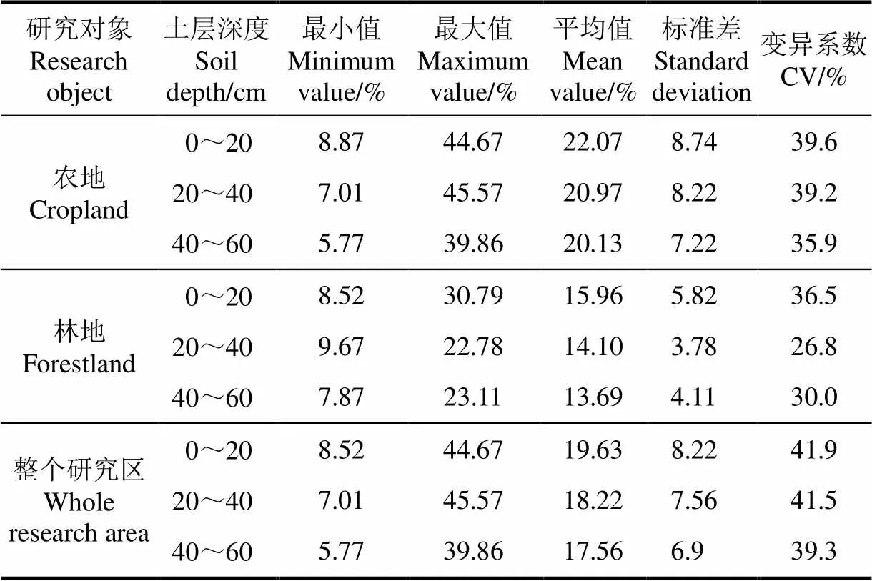
表2 土壤含水率统计学特征
2.2 不同土地利用结构土壤水分空间异质性
研究区坡面不同土地利用结构下土壤含水率变化情况如图3所示。在农地单一土地利用结构(L1)下,各坡位土壤含水率差异性相对较小,变异系数为14.82%,只有坡中与坡脚土壤水分含量有显著差异(0.05);在“农地-农地-林地-林地-农地”土地利用结构(L2)下,土壤水分沿坡面的空间变异性最大,变异系数为62.70%,坡脚农地土壤水分含量显著高于其他坡位(0.05);在“农地-农地-林地-林地-林地”土地利用结构(L3)下,土壤含水率分布规律为坡顶和坡脚显著高于中间坡位(0.05),整体上异质性较大(CV=38.25%);在“林地-林地-农地-林地-农地”的土地利用结构(L4)下,坡面土壤含水率CV为25.70%,坡中农地土壤含水率显著高于其他坡位(0.05),其他坡位土壤含水率差异不显著(0.05)。研究区不同土地利用结构是影响坡面土壤水分异质性的关键因素之一。
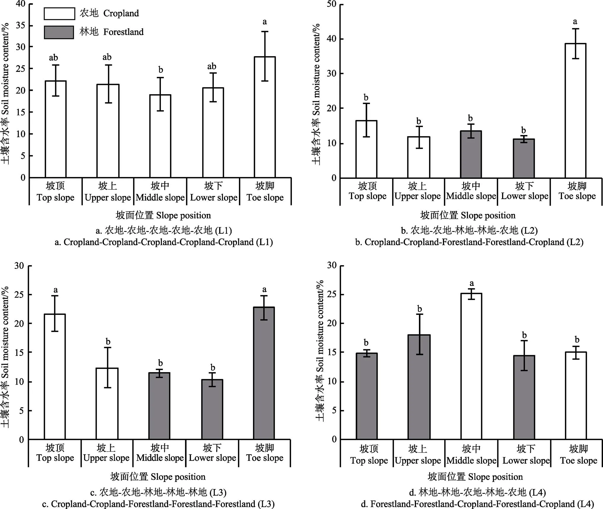
注:相同字母代表无显著差异,显著性水平为0.05,误差线代表标准差。
2.3 环境因子与土壤含水率相关性分析
本研究用RDA排序结果(图4,表3)来分析黑土区环境因子与土壤含水率的相关性。图4中,各土层箭头的夹角余弦表征土层之间的相关性。影响因子箭头连线长度代表坡位、坡度、海拔、土地利用因子与研究区土壤水分异质性相关性的大小,箭头越长则相关性越大;其箭头所处的象限代表影响因子与排序轴正负相关性;影响因子箭头在排序轴上的投影代表其与排序轴的相关性。土层箭头与影响因子箭头的夹角余弦代表两者的相关性。采样点之间的距离代表二者的差异,距离越短则两者差异越小。
分析结果显示排序轴中前两轴能够累计解释采样点和影响因子之间总方差的99.5%,所以选择前两轴来分析土壤水分与影响因子的相互关系,并用前两轴来做二维排序图。排序轴1与土地利用类型呈显著的正相关(=0.500,<0.05),与海拔高度(=0.233,=0.323)相关性虽不显著,但也呈一定程度的正相关。排序轴2与坡度表现出显著正相关(=0.584,<0.01),与坡位(=0.233,=0.323)也呈一定程度正相关(表3)。可见,第一轴主要反映的是土壤水分随土地利用的梯度变化,第二轴主要反映的是土壤水分随坡度梯度变化。
RDA排序图(图4)影响因子连线的长度中,土地利用类型的长度最长,坡度其次,坡位和海拔最短;说明土地利用类型是影响黑土区坡面土壤水分异质性的主控因素,坡度影响次之、坡位和海拔高度对坡面土壤水分异质性也均有影响。此外,从土层箭头与影响因子箭头的夹角来看,坡位与0~20 cm土层夹角为零,随着土层深度增加,坡位与土层夹角变大,但仍呈锐角,说明坡位对表层的影响最大,影响程度随着土层深度的增加而减少。坡度与0~20 cm土层呈直角,说明坡度对表层土壤水分异质性基本无影响;其对20~40 cm土层影响也较小,与40~60 cm土层夹角接近180°,有负向相关性。土地利用对所有土层的影响都较大,且呈负相关;海拔高度与各土层也皆呈负相关。
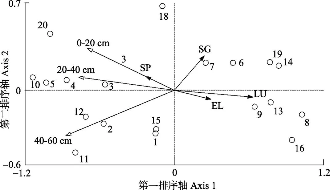
注:空心箭头代表土层,实心箭头代表影响因子,空心圆点代表采样点,1-20代表采样点;SP代表坡位,SG代表坡度,LU代表土地利用类型,EL代表海拔。

表3 环境因子与冗余分析排序前两轴的相关性
注:*代表显著性水平为0.05,**代表显著性水平为0.01。
Note:*represents significant level at 0.05,**represents significant level at 0.01.
3 讨 论
3.1 不同土地利用结构下土壤水分异质性规律
关于坡面不同土地利用结构下土壤水分异质性的规律,已有较多相关的研究。其中许多学者认为,单一土地利用结构下,坡面土壤水分异质性程度较低,而不同的土地利用结构使土壤水分异质性更复杂[22,26]。本次研究中,单一土地利用结构(L1)坡面土壤水分异质性程度(CV=14.82%)明显低于其他农林混合结构(L2、L3、L4),这点与其他学者研究的结论相同。值得一提的是,在单一土地利用结构下坡面土壤水分异质性规律,黑土区前人的研究结果与其他地区的研究结果不同[27-31],比如:苏子龙等[27]和葛翠萍等[29]的研究表明,黑土区坡面土壤含水率沿坡长增加方向呈现先降低后升高的趋势,且坡中位置土壤含水率最低,坡脚位置土壤含水率最高;而在其他地区,单一土地利用结构坡面土壤含水率随坡长增加呈增加的趋势[26,28,30]。本研究发现,黑土区单一土地利用结构下(L1)各坡位土壤含水率差异性相对较小,只有坡中与坡脚土壤含水率差异显著,虽然这一结果虽与黑土区前人的研究不完全一致,但在坡中土壤含水率显著小于坡脚含水率上是相似的,可能是因为研究区多为漫川漫岗地貌,坡长且缓(坡长可达数百米至上千米),同时样线位于阳坡,靠近坡中位置由于太阳辐射导致的土壤水分损失最多,而坡脚位置接受坡面来水较多,土壤含水率较高。
农林混用结构下,坡面土壤水分沿坡长方向异质性较大。在农地-农地-林地-林地-农地(L2)土地利用结构下,坡顶、坡上的农地土壤含水率与坡中、坡下林地的土壤含水率差异不显著,原因在于样线L2靠近坡顶、坡上位置坡度最大,长期径流下切作用使该位置农地土壤结构较差、保水性不强;而坡中、坡下林地坡度相对减缓,虽然林地的耗水量高于农地、但林冠及地被物的遮盖作用有效减缓坡中、坡下地表蒸散作用;同时由于在降雨量较充沛的季节,林地土壤含水率峰值通常在降雨后数天出现[21],因而林冠及地被物的遮盖与土壤含水率高峰出现的共同作用,使得坡中、坡下虽为林地,但土壤含水率与坡顶、坡上农地土壤含水率差异不显著;坡脚处土壤含水率显著高于其他坡位,除了降雨补充外,还因坡脚接受了较多的坡面径流和壤中流。
在农地-农地-林地-林地-林地(L3)土地利用结构下,坡顶农地和坡脚林地的土壤含水率显著高于其他坡位,一方面因为坡顶坡度较缓、径流作用不强,水分入渗相对较多;另一方面对于坡中、坡下、坡脚来说,虽同为林地,但坡脚处坡度较缓,降雨入渗也较多。在农林间隔配置土地利用结构(L4)下,坡中农地土壤含水率显著高于坡脚农地土壤含水率,这与样线L1坡中位置农地土壤含水率显著低于坡脚位置的情况不同,可能是因为样线L4坡顶和坡上的林地在降雨时由于林冠及林下植被的阻挡作用,径流强度弱,所以流经坡中时对坡中土壤侵蚀作用弱,土壤结构保持的好,土壤保水性强;而坡脚农地的土壤含水率较小则是因为整个样线林地分布较广,林冠可有效阻挡降水,加之林地和坡中农地土壤结构较好,坡面降雨入渗相对较多,坡脚接受坡面来水减少。
总之,对黑土区不同土地利用结构的土壤水分分异规律的探究,还需结合不同坡向、坡度、不同土地利用类型等因素作进一步的研究。
3.2 坡面土壤水分分异的主控因素
众所周知,坡面尺度上土壤水分异质性受控于土地利用和地形要素。地形要素可控制降雨入渗程度及坡面径流、壤中流[22,31],而不同的土地利用类型因其在拦截降水、植被蒸腾和土地蒸发、改变土壤理化性质方面的不同而成为土壤水分异质性的影响因素。坡面不同的土地利用结构因不同土地利用类型镶嵌分布,可控制坡面水文生态过程,对坡面土壤水分异质性的影响更加深远。
已有研究表明,由于研究区域及研究时段不同,土地利用类型及地形要素对土壤水分异质性的影响程度各异,主要与土壤含水率有关[23,32-33]。一般来说,土壤含水率较高时,土地利用类型为主控因素,而随着土壤含水率降低,地形要素影响上升,土地利用的影响减弱,通常情况下土地利用类型和地形要素对土壤水分异质性均有影响[18,34]。本研究中,RDA排序结果表明,土地利用类型是黑土区坡面土壤水分变异的主控因素,这与采样期降雨充沛,土壤含水率较高有关;而地形要素中,影响程度排序为坡度最大,坡位和海拔次之,这与国内相关研究的结论相似[18,29],因为坡度对降雨的入渗速率有显著影响[35],且其在地形要素中对坡面径流及壤中流的影响程度最强[22]。
3.3 黑土区坡面土地管理及土壤侵蚀防控建议
根据不同土地利用结构下坡面土壤水分的空间分布状况,合理配置坡面土地利用结构,是控制土壤侵蚀的有效路径之一[4,36]。在坡面上由于地形要素、地表植被等的不同,加之坡面土地利用结构的影响,不同位置的土壤理化性质存在差异,进而导致土壤初始含水率及入渗能力不同。而在大部分情况,土壤初始含水率及入渗能力是影响地表径流产生的关键要素[26,37]。坡面上单一土地利用结构下,地表覆盖度相近,前期土壤含水率差异小,土壤水分入渗能力相当,降雨时几乎同时产生坡面径流,其侵蚀下切作用强;此外,秋天作物收获后,地表覆盖度降低,经过侵蚀后土壤有机质流失,土壤保水性变差。而合理的配置坡面土地利用类型,一方面可以降低坡面径流的强度,另一方面可使降雨后径流产生区的径流被非产生区阻拦,提高土壤水分入渗率,可有效防止土壤侵蚀的发生[22]。本研究中,“林地-林地-农地-林地-农地(L4)”是较好的土地利用结构。因此,今后在黑土区坡面土地利用结构配置方面,考虑到兼顾防止坡面水土流失和充分利用水资源提高粮食产量2个方面,在坡面适宜进行林地、农地间隔配置,通过农林复合系统的生态效应提高土壤入渗及保水能力、减少或拦阻径流,在土地利用中防止土壤侵蚀,实现水土保持。
此外,在坡面选择合理的土地利用结构后或由于现实情况而无法实现土地利用结构优化时,对于坡耕地(坡面上的农地)也应通过合理的农业措施改善土壤结构、减少坡面径流、提高坡面土壤水分的入渗率、控制坡耕地土壤侵蚀。例如,对于黑土区的坡耕地,应该用横坡垄代替顺坡垄。研究表明横坡垄比顺坡垄更能控制土壤侵蚀,增加土壤含水率[38],因为横坡垄可以有效的拦蓄土壤水分,减缓坡面径流的下切作用。同时,秸秆还田等覆盖措施可以有效改善表层土壤的结构及入渗性能,可减少土壤水分蒸发,并从流量和流速2个方面减少径流,且覆盖度越大径流量越小[39-41];在实践上,秸秆的覆盖度要大于40%以有效控制土壤侵蚀[40]。通过免耕和少耕等方式也可以减少水土流失[42]。增加土壤有机肥和添加土壤改良剂亦可改善土壤结构,增加入渗,有效防止径流[43]。未来如何将坡面土地利用结构配置与不同的农业措施科学地结合以防止坡面水土流失是保持土壤肥力、保护生态环境的核心与关键,也是进下一步研究的切入点。
4 结 论
1)研究区农地土壤含水率平均值介于20.13%~22.07%,林地土壤含水率平均值介于13.69~15.96%,农地含水率显著高于林地含水率,且纵向上农地各层的变异系数(35.9%~39.6%)均高于林地的变异系数(30.0%~36.5%),整个研究区土壤含水率的变异系数高于农地、林地等单一土地利用类型下同一深度的变异系数,农林混合利用增加了土壤水分的空间变异程度。
2)冗余分析结果显示,整体上土地利用类型是影响黑土区坡面土壤水分异质性的主控因素(相关系数=0.500,<0.05),坡度次之(相关系数=0.584,<0.01),坡位和海拔高度对坡面土壤水分异质性也均有影响。
3)为减少坡面土壤侵蚀、防止水土流失,应通过土地利用类型的合理配置优化坡面土地利用结构,并结合有效的农业措施来优化土壤理化性质、提高土壤水分入渗能力、减少坡面径流,以兼顾黑土区保障粮食安全及保护生态环境的双重任务。
[1] Albertson J D, Montaldo N. Temporal dynamics of soil moisture variability: 1.theoretical basis[J]. Water Resources Research, 2003, 39(10): 197-204.
[2] Pan F, Peters-Lidard C D, Sale M J. An analytical method for predicting surface soil moisture from rainfall observations[J]. Water Resources Research, 2003, 39(11): 2077-2088.
[3] Legates D R, Mahmood R, Levia D F, et al. Soil moisture: A central and unifying theme in physical geography[J]. Progress in Physical Geography, 2011, 35 (1): 65-86 .
[4] Han E, Merwade V, Heathman G C. Implementation of surface soil moisture data assimilation with watershed scale distributed hydrological model[J]. Journal of Hydrology, 2012, 416(2): 98-117.
[5] Western A W, Blöschl G. On the spatial scaling of soil moisture[J]. Journal of Hydrology, 1999, 217(3/4): 203-224.
[6] Brocca L, Tullo T, Melone F, et al. Catchment scale soil moisture spatial-temporal variability[J]. Journal of Hydrology, 2012, 422: 63-75.
[7] Li Haidong, Shen Weishou, Zou Changxin, et al. Spatio-temporal variability of soil moisture and its effect on vegetation in a desertified aeolian riparian ecotone on the Tibetan Plateau, China[J]. Journal of Hydrology, 2013, 479: 215-225.
[8] Salvucci G D. Limiting relations between soil moisture and soil texture with implications for measured, modeled and remotely sensed estimates[J]. Geophysical Research Letters, 1998, 25(10): 1757-1760.
[9] Entin J K, Robock A, Vinnikov K Y, et al. Temporal and spatial scales of observed soil moisture variations in the extratropics[J]. Journal of Geophysical Research, 2000, 105(D9): 11865-11877.
[10] Ferreira J N, Bustamante M, Garcia-Montiel D C, et al. Spatial variation in vegetation structure coupled to plant available water determined by two-dimensional soil resistivity profiling in a Brazilian savanna[J]. Oecologia, 2007, 153(2): 417-430.
[11] Pan Yanxia, Wang Xiaoping, Jia Rongliang, et al. Spatial variability of surface soil moisture content in a re-vegetated desert area in Shapotou, Northern China[J]. Journal of Arid Environments, 2008, 72(9): 1675-1683.
[12] Penna D, Borga M, Norbiato D, et al. Hillslope scale soil moisture variability in a steep alpine terrain[J]. Journal of Hydrology, 2009, 364(3/4): 311-327.
[13] Cho E, Choi M. Regional scale spatio-temporal variability of soil moisture and its relationship with meteorological factors over the Korean peninsula[J]. Journal of Hydrology, 2014, 516: 317-329.
[14] Ivanov V Y, Fatichi S, Jenerete G D, et al. Hysteresis of soil moisture spatial heterogeneity and the "homogenizing" effect of vegetation[J]. Water Resources Research, 2010, 46, W09521, doi:10.1029/2009WR008611.
[15] 李小雁. 水文土壤学面临的机遇与挑战[J]. 地球科学进展,2012,27(5):557-562.Li Xiaoyan. Opportunity and Challenges for Hydropedology[J]. Advances in Earth Science, 2012, 27(5): 557-562. (in Chinese with English abstract)
[16] Famiglietti J S, Rudnicki J W, Rodell M. Variability in surface soil moisture content along a hillslope transect: Rattlesnake Hill, Texas[J]. Journal of Hydrology, 1998, 210(1/4): 259-281.
[17] 邱扬,傅伯杰,王军,等. 黄土丘陵小流域土壤水分时空分异与环境关系的数量分析[J]. 生态学报,2000,20(5):741-747. Qiu Yang, Fu Bojie, Wang Jun, et al. Quantitative analysis of relationships between spatial and temporal variation of soil moisture content and environmental factors at a gully catchment of the Loess Plateau[J]. Acta Ecologica Sinica, 2000, 20(5): 741-747. (in Chinese with English abstract)
[18] 张继光,陈洪松,苏以荣,等. 喀斯特山区坡面土壤水分变异特征及其与环境因子的关系[J]. 农业工程学报,2010,26(9):87-93. Zhang Jiguang, Chen Hongsong, Su Yirong, et al. Variability of soil moisture and its relationship with environmental factors on Karst hillslope[J]. Transactions of the Chinese Society of Agricultural Engineering (Transactions of the CSAE), 2010, 26(9): 87-93. (in Chinese with English abstract)
[19] Yang Lei, Chen Liding, Wei Wei. Effects of vegetation restoration on the spatial distribution of soil moisture at the hillslope scale in semi-arid regions[J]. Catena, 2015, 124: 138-146.
[20] Gwak Y, Kim S. Factors affecting soil moisture spatial variability for a humid forest hillslope[J]. Hydrological Processes, 2017, 31(2): 431-445.
[21] 王军,傅伯杰. 黄土丘陵小流域土地利用结构对土壤水分时空分布的影响[J]. 地理学报,2000,55(1):84-91. Wang Jun, Fu Bojie. The impact of land use on spatial and temporal distribution of soil moisture on the Loess Plateau[J]. Acta Geographica Sinca, 2000, 55(1): 84-91. (in Chinese with English abstract)
[22] 佘冬立,邵明安,俞双恩. 黄土区农草混合利用坡面土壤水分空间变异性[J]. 农业机械学报,2010,41(7):57-63. She Dongli, Shao Ming’an, Yu Shuang’en. Spatial variability of soil water content on a cropland-grassland mixed slope land in the Loess Plateau, China[J]. Transactions of the Chinese Society for Agricultural Machinery, 2010, 41(7): 57-63. (in Chinese with English abstract)
[23] 罗勇,陈家宙,林丽蓉,等. 基于土地利用和微地形的红壤丘岗区土壤水分时空变异性[J]. 农业工程学报,2009,25(2):36-41. Luo Yong, Chen Jiazhou, Lin Lirong, et al. Spatial and temporal variability of soil moisture in hilly red soil region based on land use and microtopography[J]. Transactions of the Chinese Society of Agricultural Engineering (Transactions of the CSAE), 2009, 25(2): 36-41. (in Chinese with English abstract)
[24] 张金屯. 数量生态学[M]. 北京:科学出版社,2004.
[25] Lepš J, Šmilauer P. Multivariate analysis of ecological data using CANOCO[M]. Cambridge: Cambridge University Press, 2003.
[26] Fu Bojie, Wang Jun, Chen Liding, et al. The effects of land use on soil moisture variation in the Danangou catchment of the Loess Plateau, China[J]. Catena, 2003, 54(1/2): 197-213.
[27] 苏子龙,张光辉,于艳. 典型黑土区农业小流域不同坡向和坡位的土壤水分变化特征[J]. 中国水土保持科学,2013,11(6):39-44. Su Zilong, Zhang Guanghui, Yu Yan. Variation of soil moisture with slope aspect and position in a small agricultural watershed in the typical black soil region[J]. Science of Soil and Water Conservation, 2013, 11(6): 39-44. (in Chinese with English abstract)
[28] Hawley M E, Jackson T J, McCuen R H. Surface soil moisture variation on small agricultural watersheds[J]. Journal of Hydrology, 1983, 62(1/4): 179-200.
[29] 葛翠萍,赵军,王秀峰,等. 东北黑土区坡耕地地形因子对土壤水分和容重的影响[J]. 水土保持通报,2008,28(6):16-19. Ge Cuiping, Zhao Jun, Wang Xiufeng, et al. Influence of topographic factors on soil water and bulk density in a typical slope land in the Black Soil Area of Northeast China[J]. Bulletin of Soil and Water Conversation, 2008, 28(6): 16-19. (in Chinese with English abstract)
[30] Zhu Yuanjun, Shao Ming’an. Variability and pattern of surface moisture on a small-scale hillslope in Liudaogou catchment on the northern Loess Plateau of China[J]. Geoderma, 2008, 147(3/4): 185-191.
[31] Crave A, Gascuel-Odoux C. The influence of topography on the time and space distribution of soil surface water content[J]. Hydrological Processes, 1997, 11(2): 203-210.
[32] Grayson R B, Western A W, Chiew F H S, et al. Preferred states in spatial soil moisture patterns: Local and nonlocal controls[J]. Water Resources Research, 1997, 33(12): 2897-2908.
[33] 黄奕龙,陈利顶,傅伯杰,等. 黄土丘陵小流域地形和土地利用对土壤水分时空格局的影响[J]. 第四纪研究,2003,23(3):334-341. Huang Yilong, Chen Liding, Fu Bojie, et al. The influence of topography land use on soil moisture spatial-temporal pattern in the hilly area of Loess Plateau[J]. Quaternary sciences, 2003, 23(3): 334-341. (in Chinese with English abstract)
[34] Qiu Yang, Fu Bojie, Wang Jun, et al. Soil moisture variation in relation to topography and land use in a hillslope catchment of the Loess Plateau, China[J]. Journal of Hydrology, 2001, 240(3/4): 243-263.
[35] 潘成忠,上官周平. 黄土半干旱丘陵陡坡地土壤水分空间变异性研究[J]. 农业工程学报,2003,19(6):5-9. Pan Chengzhong, Shangguan Zhouping. Spatial variability of soil moisture on steep slopeland in loess hill region[J]. Transactions of the Chinese Society of Agricultural Engineering (Transactions of the CSAE), 2003, 19(6): 5-9. (in Chinese with English abstract)
[36] Fitzjohn C, Ternan J L, Williams A G. Soil moisture variability in a semi-arid gully catchment: implications for runoff and erosion control[J]. Catena, 1998, 32 (1): 55-70.
[37] Western A W, Blöschl G, Grayson R B. Geostatistical characterisation of soil moisture patterns in the Tarrawarra catchment[J]. Journal of Hydrology, 1998, 205(1/2): 20-37.
[38] 张少良,张兴义,刘晓兵,等. 典型黑土侵蚀区不同耕作措施的水土保持功效研究[J]. 水土保持学报,2009,23(3):11-15. Zhang Shaoliang, Zhang Xingyi, Liu Xiaobing, et al. Research of soil and water conservation function of typical black soil erosion area of different tillage measures[J]. Journal of Soil and Water Conservation, 2009, 23(3): 11-15. (in Chinese with English abstract)
[39] Stein O R, Neibling W H, Logan T J, et al. Runoff and soil loss as influenced by tillage and residue cover[J]. Soil Science of American Journal, 1986, 50(6): 1527-1531.
[40] 唐涛,郝明德,单凤霞. 人工降雨条件下秸秆覆盖减少水土流失的效应研究[J]. 水土保持研究,2008,15(1):9-11,40. Tang Tao, Hao Mingde, Shan Fengxia. Effects of straw mulch application on water loss and soil erosion under simulated rainfall[J]. Research of Soil and Water Conservation, 2008, 15(1): 9-11, 40. (in Chinese with English abstract)
[41] 王全九,杨婷,刘艳丽,等. 土壤养分随地表径流流失机
理与控制措施研究进展[J]. 农业机械学报,2016,47(6):67-82. Wang Quanjiu, Yang Ting, Liu Yanli, et al. Review of soil nutrient transport in runoff and its controlling measures[J]. Transaction of the Chinese Society for Agricultural Machinery, 2016, 47(6): 67-82. (in Chinese with English abstract)
[42] 袁希平,雷廷武. 水土保持措施及其减水减沙效益分析[J]. 农业工程学报,2004,20(2):296-300. Yuan Xiping, Lei Tingwu. Soil and water conservation measures and their benefits in runoff and sediment reductions[J]. Transactions of the Chinese Society of Agricultural Engineering (Transactions of the CSAE), 2004, 20(2): 296-300. (in Chinese with English abstract)
[43] 王道涵,梁成华. 农业磷素流失途径及控制方法研究进展[J].土壤与环境,2002,11(2):183-188. Wang Daohan, Liang Chenghua. Research progress on ways and control method of agricultural phosphorus[J]. Soil and Environmental Sciences, 2002, 11(2): 183-188. (in Chinese with English abstract)
Spatial variability and its controlling factors of soil moisture on cropland-forestland mixed hillslope in black soil area of Northeast China
Guo Xinxin1, Fu Qiang2※, Lu He1, Gao Fengjie1, Hang Yanhong1
(1.150030,; 2.150030,)
Black soil area in Heilongjiang plays an indispensable role in safeguarding national food security as an important commodity grain base. Serious soil erosion and environment degradation restrict the sustainable development of local society and economy. Soil moisture is one of the key factors which control vegetation growth, soil erosion, hydrological and ecological processes at the hillslope, and it also exhibits a great degree of spatial variability. Understanding the spatial variability of soil moisture and its influence mechanism at the slope scale is essential for controlling soil erosion, increasing food production, and improving ecological environment. In this study, spatial variability of soil moisture under the effect of land use and topographic variables was investigated on a cropland-forestland mixed hillslope. The research area was characterized by 4 different land use structures (from top slope to toe slope): cropland-cropland-cropland-cropland-cropland (L1), cropland- cropland-forestland-forestland-cropland (L2), cropland-cropland-forestland-forestland-forestland (L3), forestland-forestland- cropland-forestland-cropland (L4). Soil moisture was collected biweekly during mid-August to mid-September (2016) at 20 sites located in Keshan County of Heilongjiang Province, China. Soil moisture was measured by oven drying method at the depth of 0-20, 20-40, 40-60 cm. The relationship between environmental factors and soil moisture variability was conducted by redundancy analysis method (RDA). The results showed that: 1) Soil moisture content varied from 5.77% to 45.57%; and the soil moisture content of cropland was found markedly higher than that of forestland (<0.05), with the mean soil moisture content ranging from 20.13% to 22.07% in cropland, and from 13.69% to 15.96% in forestland; the differences of soil moisture content at different soil depths were not significant(>0.05). 2) Soil moisture content showed a moderate variability in the study area, coefficient of variation (CV) in cropland (35.9%-39.6%) was higher than that in forestland (30.0%-36.5%). 3) Soil moisture variations along hillslope under the impact of 4 land use structures differed from each other. The differences of soil moisture content at middle slope and toe slope in L1 were significant (<0.05). 4) The spatial variation of soil moisture in the single land use structure (L1,CV was 14.82%) was lower than that in other cropland-forestland mixed land use structures (CV of L2, L3 and L4 was 62.70%, 38.25% and 25.70%, respectively), which indicated that land use mosaic patterns increased the variations of soil moisture. 5) RDA ordination showed that spatial variability of soil moisture was strongly influenced by land use types, and it was also affected by slope gradient, slope position and elevation. In addition, different factors control soil moisture distribution at different soil depths. This study presents that it is necessary to optimize the planting structure and take other proper methods aiming at preventing water loss and soil erosion, in order to improve soil fertility and promote the sustainable development.
soils; moisture; land use; spatial variability; cropland-forestland mixed structure; hillslope; black soil area
10.11975/j.issn.1002-6819.2018.19.016
S152.7
A
1002-6819(2018)-19-0123-08
2018-01-02
2018-07-11
黑龙江省博士后资助项目(LBH-Z14039);东北农业大学“青年才俊”基金资助项目(17QC37);国家自然科学基金项目(51279031)
郭欣欣,博士,讲师,主要从事土壤性质时空异质性及水土资源利用研究。Email:xinxin8504021@163.com
付 强,教授,博士生导师,主要从事农业水土资源系统分析、土壤性质时空异质性等方面的研究。Email:fuqiang0629@126.com
郭欣欣,付 强,卢 贺,高凤杰,杭艳红.东北黑土区农林混合利用坡面土壤水分空间异质性及主控因素[J]. 农业工程学报,2018,34(19):123-130. doi:10.11975/j.issn.1002-6819.2018.19.016 http://www.tcsae.org
Guo Xinxin, Fu Qiang, Lu He, Gao Fengjie, Hang Yanhong.Spatial variability and its controlling factors of soil moisture on cropland-forestland mixed hillslope in black soil area of Northeast China[J]. Transactions of the Chinese Society of Agricultural Engineering (Transactions of the CSAE), 2018, 34(19): 123-130. (in Chinese with English abstract) doi:10.11975/j.issn.1002-6819.2018.19.016 http://www.tcsae.org