城市公共广场的空间记忆—匈牙利·肖普朗镇历史城市中心的再生
2018-09-05匈牙利列文特萨博张忍图胡一可
著:(匈牙利)列文特·萨博 译:张忍图 校:胡一可
1 打个比方:公共广场是过去的化石
今天的路网、聚落结构以及欧洲那些历史悠久的城镇中存在的一些大型且相互联系的公共空间,通常是由已经存在了数个世纪或几千年的自然或人造结构决定的。城市在缓慢而有机地发展,使其得以保存、改造,而且不管是在整体上还是从某种程度上来说它都可以作为文化遗产,因为无论是将这些具有功能性的特征消除还是转换,均需投入很高的成本。如今,在21世纪的前半叶,高密度和多层次的城市肌理的介入使得这些因素变得鲜活起来—无论精神层面还是物质层面—对于设计师来说都是如此,这些因素比当前的关注和利益更加重要,例如城镇中作为文化遗产的区域。
在欧洲的城市(但不限于仅在欧洲大陆出现的案例)中,我们可以找到许多例子来说明这种缓慢、有机的发展和变化过程。在研究之初,先介绍一个非常著名的案例,那就是位于意大利罗马历史中心的纳沃纳广场(Piazza Navona)[1]。该广场通过导游手册和密集的古迹而为人熟知,其中的建筑和喷泉—是最伟大的设计师的独创作品—亲密共处。但是,在现场进行亲身体验会有怎样的感受呢?当置身其中,我最感兴趣的是它的空间形式起源。在1886年对外开放的纳沃纳广场上曾经矗立着罗马帝国皇帝图密善(Domitianus)的体育场,这座体育场曾经拥有15 000个座位,它的空间特征和印记甚至在2 000年后的今天还决定了广场的结构、空间以及氛围(图1)。如今,这座长270m宽55m的前竞技场成为了一个公共广场,挤满了熙熙攘攘的游客。广场边缘的墙壁下曾经有一些商店和作坊—位于图密善体育场的废墟之间—现在被教堂和宫殿包围。因此,它现今所呈现出来的空间构成和形式是由近2 000年的古迹和艺术品的更迭所决定的。尽管广场历经改造,并出现了新的建筑和大喷泉,但它的空间形态却未曾更改。今天,这个昔日的体育竞技场,随后的马术比赛场、嘉年华和马戏团表演场,以及后来的市场和集市,成为了著名的旅游胜地,也是罗马最重要的历史遗迹之一。当然,一个场所的历史不仅仅是它的空间结构和形式,还有属于自己的故事,比如博罗米尼(Borromini)的圣埃格尼斯教堂(Sant’ Agnese in Agone),它是为了纪念基督徒遭受迫害期间在图密善体育场殉道的圣埃格尼斯(Saint Agnes)。历经2 000年,建筑物在不断地发展和改变,使用功能也发生了变化,然而即使在今天,场所的起源、前身、历史和传统依然易于解读。当然,还有很多与纳沃纳广场相似的历史遗迹,在那里,城市已经进行了有机更新和自组织发展,通过这种方式保留了场所空间的演变历程。在这些案例中,往事和记忆与特定的建筑作品无关,也与建筑组群无关,而与城市、城市尺度的发展和缓慢转变有关,这通常是历史城市本身的一种集体创造。
当我们对匈牙利西部的肖普朗镇进行重要历史公共空间规划设计并协助实施时,我们参考借鉴了这座奇妙的历史性公共广场(当然还有许多其他的公共空间。然而,这一历史性的相似却为新的观念指明了方向。项目的前期工作是由建筑师、景观设计师、交通和公用设备工程师组成的团队进行的跨学科研究;我们的设计原则以及之后的整个设计过程都借鉴了该项研究的成果(图2)①。

1 纳沃纳广场鸟瞰图Piazza Navona aerial view
2 匈牙利西部典型的历史城镇:肖普朗镇及其城堡街
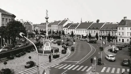
坐落在奥匈帝国(Austrian-Hungarian)边境上的肖普朗镇是匈牙利历史上最富有的一个小镇。这座罗马帝国时期的重要城镇当时被称作斯卡巴提亚(Scarbantia),早在史前时期就已经有人居住了,但是在这段历史时期,它一直是该地区的主导城镇[2]。时至今日,这所历史名城的核心仍然受限于13世纪在古罗马帝国基础上建立的城墙。基于第一次世界大战结束的和平条约,当地的公民投票决定了这座城市的归属—选择留在匈牙利而不是邻国奥地利。关于这个决定的记忆也在城市的惯称中保留了下来:最忠诚的城镇(civitas fidelissima)。这座历史城镇中心的形状,总让人想起洋葱的结构,仍然支配着城市的核心道路网、土地划分、街道比例和空间氛围。城墙内外是2个截然不同的世界[3]。当中世纪的楼宇,狭窄、蜿蜒的街道和居住房屋挤满了城墙内的区域时,公共空间两侧宽敞的底层空间—今天我们把这里称为城堡街,由之前沿着城墙的护城河填筑后发展而来—一直保持着其服务功能(图3)。
肖普朗的城堡街(Várkörút)是一条宽达 40~60m 的林荫大道,坐落在护城河外侧的坡地上,环绕着历史城镇的中心[4]。如今这条以城堡街闻名的林荫大道拥有最大的城堡集中区域,然而,地块上成行排列的建筑却来自于不同的历史时期。外围远离城墙的建筑修建于中世纪,相关记录首次出现于1400年。内侧建筑则很晚才出现在历史记录中。据派尔编年史(the Payr Chronicle)记载,早在17世纪初城堡的护城河边就出现了沿河布置的摊位。1676年大火之后,沿河摊位的数量增加,城市也从这一地块中获取了大量的利润[5]。城市土地被业主们逐步购买和开发,除了木制建筑外,他们也建造了永久性的石筑建筑。曾经建立在护城河上的仓库已与商店合并,而底层带商铺的住宅则成为城堡街的经典而留存至今。护城河在库鲁克(the Kuruc)围城战之后失去了防御功能,后来被填筑,从此成为商业场所。1776年,只有内侧的一排建筑成为格拉本大街(Grabenrunde)的界面,如今整个城堡街所使用的名字“格拉本”在1869年才开始被广泛接受[6]。到18世纪末,城堡街的立面改造活动日益频繁,导致洛可可和路易十六风格建筑的大量出现(其中大部分建筑毁于二战的1944—1945年间)。最后,在19世纪,许多这样的小房子被赋予了浪漫主义色彩。1900—1923年间,肖普朗的电车轨道线(作为匈牙利米轨电气化公交网络的一部分)穿越该区域,虽与今日城市的风采不同,但当时的明信片见证了交通设施的发展历程。在1941—1944年间,曾经由鹅卵石铺就的城堡街变成了一条介于Ikvahíd街和Árpád街之间的三车道机动车路(中间是行车道,两侧为便道)。1945年以后,场地中的建筑被重新编号,1949年这条街被改名为Lenin körút,直到1989年 10月31日苏联入侵的战争结束,它才恢复了原来的名字。
就像沃纳沃广场保留了罗马时期图密善体育场的遗迹一样,本项目中,城墙揭示了护城河系统的空间性,并融于肖普朗的城市结构中。如同化石检测一般:这座城市充满了防御工程的遗迹。而这类空间形式的创建是有机城市发展的优秀范例。
在城堡街复兴运动开始之前,场地现状早在20世纪中叶就已形成。当时,交通系统的规划发展是基于Pál Boronkai已有的规划—道路总是沿着挡土墙而建,形成组织严密而又彼此分离的交通路线(便道)。以机动车交通为主导的规划限制了人行交通,同时将曾经连续的空间纵向分割。设有交通指示灯的十字路口、辅路以及在路上穿行着寻找停车位的机动车等,都将行人可行走的空间限制到一条极其狭窄的沿着挡土墙的小路上。主要道路从久尔(Győr)开始,穿过城堡街最后到达维也纳(Vienna),这一工程布局系统与二战后的发展情况相适应[7]。事实上,在更新之前整条城堡街是连片的停车场。城市中大量广阔的公共空间和大型广场被过度建设和连接:整个区域充满了挡土墙、道路和遮挡视线的绿篱。在城堡街建筑的底层,酒店和商业的传统功能仍然处于主导地位,没有附属的公共空间与其相连接(例如露台咖啡厅、户外餐饮区)。公共广场的建筑元素(历史建筑)处于一种低审美、低科技的状态,也缺乏能使城堡街具有识别性的单一且完整的空间形象。圣母玛利亚石像(the statue of Virgin Mary)和忠诚之泉(the Fountain of Loyalty)之间的区域是肖普朗最重要的公共空间。然而,它被挡土墙和台阶分割成了2个不均衡的区域(图4、5)。
3 跨学科研究的背景、过程以及方法
虽然对场地(历史、地形和形态)的定位、功能、社会环境等方面的初步研究是任何建筑设计过程中不可或缺的步骤,在基于丰富且复杂的历史层次以及相应的城市肌理进行设计时更是如此。在肖普朗城堡街漫长的筹备和规划过程中,以上因素在工程方面均得到了充分的考虑,从而形成了一个具有跨学科性质的研究过程。
设计前期强调应用研究(而非基础研究)非常重要,因为研究的各个方面及成果与设计草图的备选方案直接相关,并嵌入在设计决策之中。在回顾整个过程时,我们可以就真正的研究型设计展开讨论,最终的规划决策依据研究的问题及相应结果而产生,复杂的公共空间振兴计划本身就是通过这种方式实现的。
我们以该镇的城市形态、结构和历史的初步探索作为研究背景。背景材料以及城市综合发展策略成为制定整个城市全面概念的基础,意味着对这些抽象资料的处理是我们在设计阶段的首要任务。此外,也不能过分夸大现场分析的作用。在对初始资料进行抽象总结之后,设计团队在设计区域及其毗邻地区进行多次访问和调查期间,采用了非常切实而具体的方式,即观察法,并准备了场地的图表资料,试图总结出该地区的主要问题和潜力。SWOT分析法同样对我们有所帮助:在研究初期,我们总结了优势—弱点—潜力—风险矩阵。在我们进行设计干预之前,该地区的严重问题是在SWOT分析法的基础上确定的,具体如下[8-9]:
1)超载的交通切断了城堡街内外的弧形线路,巨大的公共空间使用情况也不容乐观。
2)除了市中心风景如画的狭窄街道之外,没有公共空间可以作为城市空间为公众提供开放且整洁的环境。
3)该区域绿地匮乏。
4)缺乏能使城堡街充满城市的繁华和生机所需的多面且精致的城市空间品质。场地中仍然存在着一些功能可以将广场变成活动空间,比如历史悠久的集市。
5)街道两侧建筑底层的功能结构过于松散,也因为公共空间不尽如人意—基本上仅限于2条人行道—所以不鼓励城市服务设施(通常为餐饮)的所有权和功能的改变。
起初,场地的巨大潜力可以从以下因素中获得:
6)城堡街承载着串联城市空间的功能,事实证明它将对扩大城市公共空间范围做出巨大贡献。
7)城堡街的特点是拥有令人兴奋但未得到充分利用的景观环境。
8)该区域的特征(宽度和长度的比例关系)使它可以形成更加连贯的城市绿地,其中的植物以密植为主。
9)成熟的发展概念有望成为形成肖普朗形象的决定性因素。
10)通过布局的概念创新,两侧的沿街立面以及建筑和城市景观造就了该地区的美学价值。
进一步的研究在过程和方法方面得到了相关学科的支持。一方面,我们完成了建筑空间结构的历史研究,并在此基础上分析了城堡街作为公共空间的发展历程、空间位置关系、各个时期的空间使用及其动态变化。我们团队的交通工程师在设计区域及其毗邻地带进行了交通流量统计,以便记录规划前期的状态,同时也为了获得在此条件下公共场所重建后的基本信息。通过支路干预最大限度地减少设计区域(城堡街,即环绕市中心的林荫道中最宽阔的区域)的过境交通量,并且转移大量车流的方式是可能的。与此同时,在道路网络绕过已经形成的城市中心之前,有必要将直达市中心另一侧的林荫大道改造为双向车道,以使其吸纳过境交通。然而,这种干预必须要进行非常周密的交通建模,在此期间,我们也确信并且可以说服决策者们相信这种重大的交通工程干预,即城市交通重组,在不对其外部区域造成不利影响和破坏的条件下将会使设计区域受益。
在平面层面、二维空间研究和同类城市尺度的规划设计,以及在人视点可感知获得的实况之间存在着基本有序的强关联性。出于该原因也为了给决策者或各种论坛提供清晰可辨的可视化材料,我们拍摄了行人高度以上8~10m的高视角照片,由于特殊的视点高度,产生的照片同时具有顶视图和透视图的优点。无论如何,这些图像已经证明了它们对演示文稿而言是不可或缺的,而且也适用于我们的场地分析。
在规划过程中,我们多次参加了以参与式设计闻名的论坛和讨论,在那里,我们通过关注特定问题(例如,自行车交通、环境保护、停车方式、城市形象),针对感兴趣的人群或特定的民间组织来进行讨论,并听取了相关团体的意见。我们的规划过程不能被看作是一种参与式模式,因为它具有复杂的工程背景,并且需要利益相关方的共同参与,虽然这样做会导致人们对统一的结论产生质疑,但是这些论坛的反馈意见却是研究中的重要信息。
我们试图在研究完成阶段整合各方面结论,并通过排列和组合的方式来检测各个方面不同“层次”的关联性。我们创建了问题地图,这为基于研究的设计方法奠定了良好的基础。整合系统的设计基于对各方面不同层次的优先排序。然后,不仅在研究阶段,在整个设计过程中均对交通、景观设计、城市空间的使用进行了系统的管理—该公共空间的结构轴线就是在类比五线谱的过程中形成的。

2 肖普朗的风景(细节)The view of Sopron (detail)

3 1964年的城堡街Castle District, 1964
4 城堡街的再生
2009年秋天,肖普朗市政厅宣布了一个名为“肖普朗—城堡街复兴”的国际开放性街道建筑竞赛。Hetedik Műterem Kft联手景观设计师GEUM Műterem Kft最终赢得了这场竞赛②。在历经了许多年的设计之后,宏伟壮丽的公共空间更新改造一期设计终于在2015年问世,完成改造的区域面积大约为15 000m2。
城堡街的美源自其横截面连续不断的变化和在近0.5km长的区域内不断改变的空间关系,这些特点都归功于城堡街的活力和包容。这种被称为纵向活力性和横向多样性的二元关系,是我们希望在城堡街更新规划中延续并加强的。规划的主要概念是:让人们站在城堡街的任何一个地方,都能感受到这是整个区域中重要的组成部分。然而,达成目的须使用相对温和的设计手法,因为沿着城墙内外排布的建筑立面的历史发展与各城市设计要素息息相关,因此,主导地位的争夺完全没有必要。
作为匈牙利最重要的风景园林评论家之一,Sándor Bardóczi写到:“有时,城镇会在展示自身形象时遭遇困境,从而错失成为一个真正的天堂的机会。地方色彩是一种难以捉摸的物质,即使我们每天都在城镇中穿行,我们也不会总是注意到它是何时消失的。当衰落(包括公共空间的衰落)逐渐开始时,强烈的外观的重新演绎会产生一种突如其来的震撼效果,但这也可能会为公共空间的再利用打开新的视角。肖普朗城堡街的开放空间长期处于一种被忽视的荒芜状态和缺少生气的沉寂之中,这一切在现在回顾起来尤其明显,特别是在城堡街已经完成改造的区域和未经改造的地区之间的分界处。回想起来,最令人沮丧的应该是第二次世界大战和世纪之交之间的那段时期,当时这些场所被有组织地用于交通运输和停车。如今,我们用一条以步行为主的长廊代替了之前的功能,把城市生活、步行活动、自行车交通、集会作为主要功能,并且减少了交通区、咖啡馆和会议设施。”
在历史环境和空间状态基础上,设计的主要目标是创造一个外观匀质的坡地,并延展到城墙之外。首先是材料使用的新概念:为了确保空间结构的一致性,我们因此选择了深色的、庄重且自然的硬砖以及花岗岩。花岗岩条纹的形状就像乐谱线一样,能在不影响整体性的前提下,与公共建筑不同的功能特点相协调。在后来的工作中发现,我们工作室提出的这种形象化比喻对于推动设计进程十分有益。像这样一个项目,在概念统一的设计过程中受到的威胁是许多充满善意的关注,而不是施工工期的讨论。当我们谈到这个不规则的、曾经的护城河时,我们总是会回到竞赛的坐标原点,所以我们的想法会变得与最初的概念非常相似,因此也就不会破坏项目的统一性。然而,维护交通、金融、自行车或机动车泊车点的公民宣称,公共设施的有机混合、城市政策以及不断提出的功能性需求可能会对场地现状造成强烈侵蚀,但是被延迟的设计进程却提升了设计的品质(图6)。
4 重建之前的城堡街,2009年The Castle District before the reconstruction, 2009

5 城堡街玛利亚雕塑前景观Castle District with the Maria-Statue in the foreground
在对交通系统和空间利用问题进行探讨和有效检测之后,设计师决定采用“单车道”形式。现有道路被保留了下来,但是对交通量进行了限制,步行区、自行车道、城市绿化带以及露台都将被放置在这条大道上。宽阔的内部步行区和外部交通线路的建立,及其规模的变化都使行人从中获益。根据所提出的空间组织原则,整条城堡街将按照棋盘式街道空间进行布局。该系统还可以应对使用功能的多变性,即在确定的线性空间内放置最适合的户外设施(图7)。
公共设施重建之后,依照新的交通系统重新安置了街道照明,并翻新了人行道。在考虑公共设施分布密度的同时,景观和植被也得到了最大程度的关注。高耸的刺叶植物被种植于中心区,而树冠较小的树种则分布于建筑物周边—一方面是为了确保历史街区主立面的视野,另一方面则是为了满足人行区域的不同功能需求(图8)。
Barnabás Winkler在他的评价中如此形容更新后的公共空间:“来此的游客,特别是肖普朗的居民们,看起来都对重新焕发了活力的城区感到非常满意。城堡街不再只扮演流动空间的角色,在这里有真正的城市生活……曾经消失不见的亲切氛围再次回到这个用现代材料重建但仍然具有小城镇的舒适感的城堡街。……通过对交通系统的合理设置,公共交通的速度被有效放缓。绿地比例并未减少,事实上,它们可以作为遮盖地面铺装的装饰细节。”
更新后的城堡街恢复了原来的空间结构,如果查看旧的明信片、绘画和照片,你就会发现统一的公共空间并不仅仅只是古建筑转译的载体。公共空间的使用功能基于旧有模式:集市成为了餐饮区和城市活动的集会场所。在长达7年的公共空间更新设计过程中,许多民众认为由于交通的限制,主广场可能会被弃置。无论如何,肖普朗的商业活动、城市事件和市民生活在广场再生之后都会占据这片区域。因此,我们设计了一种可以承载各种活动的硬件设施。更新后的空间结构不仅产生了一种具有21世纪标志的充满秩序且统一的场所环境,还产生了一种直接相关的结果:城市空间的使用几乎迅速地转移到了城市历史中心的再利用上。
项目的最终目标是创建一个连片且繁华的广场,在那里,车行道仅作为交通目的使用,餐厅和商店的分布更多地受益于复兴之前的格局。因此,市中心可以重新获得经济效益和公众支持,并成为肖普朗的地标。
公共空间局部保留了城市的有机发展。城市历史中心重建的责任在于重现这种空间记忆,它使日后的保护成为可能,当然也为了迎合当代的需求。肖普朗城堡街的振兴是一项复杂的市政工程和城市规划任务,需要非常严谨的团队协作才能获得与以往相统一的空间格局,并且保持和展现空间的一致性。在该项目中,不仅需要保护建筑物,而且作为项目和城市一部分的空间特性也应该得到特别关注。除了将城市历史中心的空间印记保留下来,并使后人能够清晰地解读场所空间之外,我们没有做其他多余的设计(图9)。
5 后续工程及影响
城堡街第一个也是最长的工程阶段已经在2015年底结束,它也表明了该项目下一步的发展趋势,即城市历史中心区的周边区域。市中心公共广场的更新计划也已经开始实施,预计和另外2个大型且毗邻的城市更新区域小城堡街(Kisvárkerület)和赛切尼广场(Széchenyi tér)同时完工。其中,作为城市更新项目第二阶段的小城堡街即将完成。虽然赛切尼广场的空间布局要求有一个完全不同的概念,但使其保持与整个区域的统一性和一致性也是非常重要的(图10)。
在肖普朗,赛切尼广场是围绕着市中心的一系列公共空间中最大的广场,尽管它是城堡街不可分割的组成部分,但它仍然具有独立性。塞切尼广场兼具空间集合体与独立点2个身份:就其在城市空间结构中的位置来看,它是一个城市广场,但从使用功能上来说,它又是一片绿地或者说是城市公园。几个世纪以来,它一直按照社会、自然和文化条件不断发展,但如今的空间格局只是以往的缩影。在思考赛切尼广场的复兴规划时,我们设想了由道路和开阔空间交织而成的具有部分铺装的场地,最重要的是,这片场地中要有一片相当大的绿色为公共广场和公园提供某种形式的过渡,从而将这2种城市空间的功能和效益结合起来。沿着建筑立面分布,即塞尼切广场一侧的人行道得到了扩展—作为城堡街的延长部分—因此,该广场将与城市结构单元城堡街相连。出于内部功能安排的考虑,细长的广场被横向划分。设计尊重2处现有古迹赛切尼广场和“旗忠”雕塑(Flag of Loyalty)的主导地位,但也为它们创造了一个新的框架,即重建的轴对称空间结构。我们构思规划一个地毯式空间,即营造一个抽象的、由专门的交通体系环绕的城市广场。就城堡街已经完成的工程项目而言,建筑空间的纵向组织结构使人联想起活页乐谱,因为它可以在这个整齐划一的城市网格中捕捉广场的元素(绿地、铺装路面、长凳、水面、纪念碑)。
接下来的几个阶段预计在近几年完成,在此期间,这座具有空前美景的历史悠久的城市广场将以复杂的方式进行更新。具有上百年历史的城市将会创造它的21世纪形象,即成为由一系列公共空间片段统一组成的现代空间,并且能用特有的方式处理不同的场地问题。
首先,虽然这个项目最主要的阶段已经获得了很多荣誉和奖项。但与建筑师、景观师以及值得纪念的奖杯相比,空间的使用者才是赢得这些成就的最大功臣:他们将活力带回了城堡街。该城市的前首席设计师对第一阶段的工作成果进行了总结和评价:“列文特·萨博和他的同事们所做的规划设计旨在告诉我们,设计者已经意识到道路和广场、移动和到达同时存在是空间的主要问题。这种空间特征具体表现为:在移动期间它会被人们学习和理解,而且移动的过程会将体验和娱乐这2种抽象活动联系在一起,凯文·林奇(Kevin Lynch)称之为移动系统。沿途的视觉景观和具有不同特征的空间片段展现了一个完整的空间演替序列。这种移动和变化是为了在体验诗意空间序列的过程中形成一种基本体验,其中各种各样的铺装路面和绿化带交替出现—为露台、水景以及休闲和娱乐活动提供了空间,所有这些都是一个富有生机,充满活力的城市广场必不可少的要素。本文引用了音乐与场地之间的联系。而且并非巧合的是,竞标方案的技术描述,作为设计方案的基础,早就考虑到这一特殊的创作原则,并对照音乐记谱法将带状的场地空间分解为一张乐谱。城市空间结构中出现的元素谱成了乐符,绿地和带状铺装则是交替出现的音乐主题。……我们还应该联想到建筑的结构方式—严格的自律,它为我们展示了景观空间的决定性因素,而这些人们已经达成基本共识。不时出现的城墙,将几个世纪以来出现的建筑立面整合到了这条由墙体围合而成的空间带中,从远处看,它与塔楼形成交相辉映的景观。令人耳目一新的设计概念并没有与一系列的历史建筑相冲突,而是全方位地提升了它们的空间体验和享受。显然,这才是这项设计的主要目标。凭借着色彩和空间结构,新的建筑形象将会成为肖普朗历史城区中立、没有过多倾向性的背景。[10]”
总之,我们可以这样说,已完成的肖普朗城堡街公共广场复兴项目产生了可从建筑实践角度验证的结果,即它不仅为肖普朗的城市空间带来可见和公认的动力,同时也改变了空间的基本使用功能,使该区域恢复了生机与活力。在长期的工程项目实践过程中,实现跨学科建筑研究和设计的紧密结合,具有重要的意义和模型价值。这种以研究为基础的设计,其综合性质不仅影响了研究的方法论,而且也体现在研究成果之中。占据历史城市中心区近一半面积的公共广场更新项目,从整体到细部保持了统一性,作为一个开放系统它具有很强的包容性:适应历史、形态构成、复杂而动态的空间使用模式,以及建筑与公共空间的整合[11-13](图11)。
注释(Notes):
① 迄今为止,该项目中规模最大、最引人注目的部分已经完成并获得了多项匈牙利国内以及国际奖项。2016年,作为入围著名的欧洲密斯·凡·德罗奖的匈牙利项目之一,它获得了pro建筑奖(the Pro Architectura Prize)的优秀建筑作品以及国际古迹遗址理事会奖(the ICOMOS Award)颁布的“历史建筑最佳重建奖”,并于同年荣获塞尔维亚第20届建筑沙龙的DaNS城市设计沙龙奖。该项目已经在匈牙利和国外的几个展览中展出。
The largest and most spectacular element of the project,which has been realized so far, has received many Hungarian and international prizes. In 2016, it was one of the Hungarian nominees of the prestigious European Mies van der Rohe Prize, received the Pro Architectura Prize for outstanding architectural works as well as the ICOMOS Award for the best reconstructions of historic buildings,and in the same year it was awarded the Salon Award in urban design category at DaNS 20th Salon of Architecture,Serbia. The project was presented at several Hungarian and foreign exhibitions.
②总设计师:Hetedik Műterem Kft.;主建筑师: Levente Szabó;景观设计师:Csenge Csontos,Borbála Gyüre,Gergely Lád;合作建筑师:Balázs Biri,Jessica Dvorzsák,Dávid Kohout,Orsolya Simon。
General designer: Hetedik Műterem Kft., architect in charge: Levente Szabó, landscape design: Csenge Csontos, Borbála Gyüre, Gergely Lád, co-architects: Balázs Biri, Jessica Dvorzsák, Dávid Kohout, Orsolya Simon
③ 图1来源于档案照片;图2由迈克尔·扎卡赖亚斯绘制,1700年,肖普朗图书馆馆藏作品,编号Kp.54.510.1;图 3 由 Lechner Nonprofit Kft. Dokumentációs Központ / VÁTI©Fortepan提供;图4、10由courtesy of Hetedik Műterem提 供; 图 5由 Balázs Danyi拍 摄,2016年; 图 6~9 由Balázs Danyi拍摄,2016年;图11由 Donát Rohonczi绘制,2017年。
Fig. 1 © archive photo; Fig. 2 © Michael Zacharias, 1700,Sopron Museum, Kp.54.510.1; Fig. 3 Image courtesy of Lechner Nonprofit Kft. Dokumentációs Központ / VÁTI©Fortepan; Fig. 4, 10 © courtesy of Hetedik Műterem;Fig. 5 © Balázs Danyi, 2016; Fig. 6~9 © Balázs Danyi,2016; Fig. 11 © Donát Rohonczi, 2017.

6 城堡街扩建区域The widening part of the Castle District
1 The Analogy: Public Squares as Fossils of the Past
Today’s road network, settlement structure,and the larger, contiguous units as well as certain specific parts of European historical towns have often been determined by natural or artificial formations that had already existed centuries or millennia before. The cities’ slow, organic development has preserved, transformed, and used as heritage anything that could be used from these formations either in whole or in part,which features were functional, or the demolition or conversion of which would have cost too much. Today, in the first half of the 21stcentury,intervening in such a dense and multilayer urban tissue makes the factors tangible—both in the intellectual and physical sense of the word—also for the designer, which factors are more important than current considerations and interests, for example the heritage of these districts of a town.
Among the European cities (but not exclusively in cases observable on this continent), many examples can be found for this slow, organic development and metamorphosis. At the beginning of the study,I would like to introduce one of the most wellknown examples, the breathtaking Piazza Navona in the historic center of Rome, Italy[1]. At this place,which is well-known from the tourist guides and densely built up with unique monuments, the buildings and fountains—individual creations of the greatest creators—are seen in close coexistence.Still, what could be experienced on the spot and personally, when I was there, I was excited about it the most was the origin of the spatial form. The former 15,000-seat stadium of Domitian (Titus Flavius Domitianus) Roman emperor, opened in 86,once stood at the site of Navona, the spatial imprint and memories of which define the structure, sense of space and atmosphere even today, almost two thousand years later (Fig. 1). The 270m long and 55m wide former arena is today a bustling public plaza crowded with tourists. There were once shops and workshops in the boundary walls of the square—between the ruins of Domitian’s stadium—now it is surrounded by churches and palaces. Thus, its form and shape today is determined by the vanished place of a nearly two thousand years old facility and work of art. Although the successive ages had constantly shaped the square, new houses and great fountains were built, but the spatial form remained unchanged.Today the former arena of the stadium, later the venue of equestrian competitions, carnivals and water circuses, then markets and fairs, is a prominent tourist destination, one of Rome’s most important historic sites. Of course, the history of a place is not only about its shape and form: also the church of Sant’ Agnese in Agone by Borromini has its own story, commemorating Saint Agnes who died of martyrdom in the Domitian stadium during the persecution of Christians. Two thousand years: the building stock has been constantly evolving and changing, the usage has also changed, yet the origin, the former character, history and tradition of the space are easy to read even today. Of course, there are many historical sites similar to Piazza Navona, where the organic, spontaneous development of the city has overgrown and this way preserved the spatiality of this evolution and story.In these examples, remembrance and memories are not related to a particular architectural work, neither to their multitude but to the spatial memory of an urban, city-scale development and slow transformation which is a collective creation, as is usually the historical city itself.
We envisaged this fantastic historical public plaza (and of course many others) when we worked on the plans and assisted the implementation of one of the most significant historical public spaces in Sopron, Western Hungary.This historical analogy, however, primarily set a direction for the idea of renovation. The concrete steps were preceded by a kind of interdisciplinary research involving architects, landscape designers, transport and utility engineers; and our design principles, then the entire design process itself could directly rely on the findings of this research (Fig. 2)①.

7 城堡街丰富的横断面Cross-sectional diversity of the Castle District
2 A Typical Historical Town in Western Hungary: Sopron,and the Castle District
The town of Sopron is a settlement richest in monuments in Hungary,standing on the Austrian-Hungarian border. It was already inhabited in prehistoric times, known as Scarbantia, an important town during the Roman Empire, but it has always been a privileged settlement of the region throughout history[2]. To this day, the historical city core is determined by the town wall which was erected in the 13thcentury on foundations originated from the ancient Roman Empire era. On the basis of the peace treaty ending World War I, the status of the city was decided by a local plebiscite, voting for belonging to Hungary instead of the neighboring Austria. The memory of this decision is preserved also in the city’s standing locution: “The Most Loyal Town”(civitas fidelissima). The shape of the historic town center, reminiscent of the onionskin’s structure, still dominates the city’s central road network, the land divisions, and the streets’ proportion and atmosphere. In- and outside the city walls, there are two essentially different worlds[3]. While medieval buildings,narrow, winding streets and residential homes dominate the zone inside the town wall, the ground floor zone along the two sides of the wide and broad public place—today called the Castle District and developed by filling the former moat along the town wall—has always been filled with service functions (Fig. 3).
The Castle District of Sopron is a 40~60 meter wide boulevard, which was formed on the outer skirt of the moat running along the city walls that encircled the former historical core of the town, on the so called glacis slope[4].The boulevard today known the Castle District includes the largest part of the castle belt zone; its rows of houses, however, are different in their history.The outer row of houses, which is farther away from the former town wall,was already there in the Middle Ages, the first mention of it is from 1400. The inner side is mentioned much later in historiography. According to the Payr Chronicle, there were fair booths along the castle moat already at the beginning of the 17thcentury. After the Great Fire of 1676, their number grew, and the town earned a lot of income from the wages of land[5]. Town-owned plots were gradually bought and extended by the booth owners, and in addition to the wooden constructions, they have placed permanent stone constructions too. Warehouses were built in the former moats, some stores merged, and residential houses were built with shops on the ground floor, typical of the Castle District up to the present day. The moat lost its defense role after the siege of the Kuruc and was later filled up, and from that time its environment began to become the place for commerce. In 1776, only the inner row of houses were called Grabenrunde, this name started to be commonly used for the whole of today’s Castle District only from 1869[6]. The transformation of the Castle District facades became very intense by the end of the 18thcentury,resulting in the high number of Rococo and Louis XVI style buildings (most of them were ruined in 1944–1945, during World War II). Finally, during the 19thcentury, many such small houses were converted with Romantic decorations. From 1900 to 1923, the tramline network of Sopron (as part of the metre-gauge electrified public transport network in Hungary) crossed the district,with no trace in the city today, but postcards of the time bear witness to this progressive level of development of the transport infrastructure. Between 1941 and 1944, the former cobbled Castle District was transformed into a three-lane structure between Ikvahíd utca and Árpád utca (with the traffic lane in the middle and service roads on the two sides). After 1945, the houses were re-numbered,in 1949 the street’s name was changed to Lenin körút, which was in use until 31 October 1989, the end of the Soviet invasion, when it got back its original name.
As the Piazza Navona preserved the formation imprint of the former Domitian stadium in Rome, in this case the town walls make observable the moat system’s spatiality and its elimination and incorporation in Sopron’s urban fabric these days.As we would examine a fossil: the city overgrown the former defense object. The created spatial formation is a beautiful example of organic urban development.
Conditions, prevailing before the start of design process of the Castle District’s renewal,had developed during the second half of the 20thcentury. At that time, a traffic system was developed on basis of Pál Boronkai's plans with retain walls,articulated and separated traffic routes (service road). This traffic-dominated state restricted pedestrian traffic to the minimum and at the same time it separated the once contiguous space longitudinally. Traffic light intersections, service roads, cars passing and searching for parking place restricted pedestrian traffic to a narrow stripe along the walls. The engineer-constructed system was fitted to the conditions developed after World War II, when the main road from Győr led through the Castle District to Vienna. Prior to the conversion, actually the whole Castle District was one contiguous parking lot[7]. The generosity of the extremely wide public place, the large and contiguous square worthy of a city was overbuilt and over-articulated: the area was filled with retaining walls, roads and hedges blocking the view.On the ground floors of the Castle District houses,the traditional functional dominance of hospitality and trade was not accompanied by corresponding public space connections (e.g. coffee terraces,outdoor catering areas). The architectural elements(historic buildings) of the public piazza were in poor aesthetic and technical condition, and the area missed a single, integrated image that could have given identity to the Castle District. The place between the statue of Virgin Mary and the Fountain of Loyalty is one of the most important public spaces in Sopron. Nevertheless, it was unjustly fragmented and divided by retaining walls and stairs(Fig.4, 5).
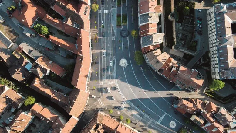
8 城堡街垂直鸟瞰图Vertical aerial view of the Castle District
3 Background, Process and Methods of the Interdisciplinary Research
Although preliminary research on location (its history, topography and morphology), he function,sociological environment etc. is an indispensable part of any architectural design process, this is especially true when the base of the design is an urban tissue rich and complex in terms of its historical layers. During the long preparation and planning process of the Sopron Castle District,all these considerations were complemented by engineering aspects, which formed the research process into one with an interdisciplinary character.
It is important to emphasize in advance that this research process cannot be considered as basic but as applied research, in which the aspects and results of the research were directly linked and embedded in the sketching of design alternatives and also in the design decisions. We can talk about a true research-based design when looking back at the whole process, during which the final planning decisions could rely on and be formed by the questions and results of the research, and the complex public space revitalization itself was realized this way.
The background of our study was based on the available preliminary studies on the morphology,structure and history of the town. These background materials, as well as the Integrated Urban Development Strategies formulating comprehensive concepts for the city as a whole,meant such abstract knowledge base the processing of which was our primary task already at the design phase. In addition, neither the on-site analysis can be overestimated. With my colleagues, during several visits and examination of the design area and its direct neighborhood, after the abstraction of preliminary materials, with a method based on very tangible, eye-level observations we have prepared the chart bases, which attempted to summarize the main problems and potentials of the site. The general method of SWOT analysis also helped us here: as a starting point we summarized the matrix of strengths-weaknesses- potentials-risks. Prior to our intervention, the serious problems of the site were formulated on basis of the SWOT analysis as follows[8-9]:
—Traffic overload cut off the outer and inner arch of the Castle District, while the utilization of the wide public space was extremely bad.
—Besides the narrow streets of the picturesque city center, there were no public spaces that would provide open and clear areas which could be used as urban spaces.
—There was little green area.
—There was a lack of multi-faceted and articulated urban space qualities that would have filled the Castle District with an intensive urban life.Just like long ago the fairs, there are still functions that are able to turn the square to an event space.
—The functional structure on the ground floor of the buildings along the two rows of facades was overly inhomogeneous, since the unfavorable public place—essentially limited to two sidewalks—did not encourage ownership and function changes in direction of urban services(typically to catering industry).
And at the start, the great potentials of the location were found in these factors:
—The Castle District carried the promise of a contiguous urban space, about which we could clearly demonstrate that it would greatly contribute to the expansion of the urban spatial spectrum of the city.
—The Castle District was characterized by exciting and insufficiently exploited environmental connections.
—The features of the area (width and length dimensions) made it possible to form more coherent green areas, mainly in the form of an intense tree planting.
—A well-developed concept carried the hope of becoming a determinant identity-forming element of Sopron.
—By creating a good layout concept, the beauty of the facades on the two sides, as well as their architectural and cityscape value promised the appreciation of the place.
The process and methodology of further research was supported by approaches to different disciplines. On one hand, we worked on the architecture historical research of the historical spatial structure, in which we analyzed the development of the Castle District as a public space, the spatial relations of the Castle District, the space usage of each periods, and their dynamics. The traffic engineer members of our team performed traffic counts in the design area and its immediate vicinity, in order to record not only the pre-planning state, but also to gain basic information on the conditions after the public place renewal. Minimizing the transit traffic of our design area, that is, the Castle District, which is the widest section of the boulevard around the historic city core, and displacing a significant part of traffic from this area was possible with a kind of bypass intervention. In the meantime, until the road network bypassing the city center is finished, it was necessary to convert the boulevard section around the other side of the direct city core to a two-way road and also to make it attractive for transit traffic. However, this intervention had to be preceded by very thorough traffic modeling, during which we became convinced and could persuade also the decision-makers in that respect that the significant traffic engineering intervention, i.e. the reorganization of traffic within the city, would benefit the design areas without causing any damage or disadvantage outside of them.
There is a fundamental methodical tension between the ‘site plan’ level, two-dimensional study and design of this type of city-scale plans and the grasping of reality that is perceptible at eye level.For this reason, and partly in order to present a sufficiently perceptible visualization material that can be communicated to decision-makers or at various forums, we have taken photos from viewpoints approx. 8~10 m above the pedestrian level that could combine the benefits of top views and eye views due to their special viewpoint height. However, these images have proved to be indispensable not only for the presentations but also for our site analyzes.
During the planning process, we participated on a number of occasions in forums and discussions being well-known from the participative design methods, where we discussed our plans in general for the interested or for specific civil organizations by focusing on a specific issue (e.g.bicycle traffic, environmental protection, parking versions, city image) and listened to the comments of these groups. Our planning process cannot be regarded as one following a participatory model since it had a complex engineering background and would require the involvement of so many interest groups that would have made the unified outcome questionable, however, feedbacks from these forums were important research inputs.
We tried to integrate all these aspects already at the end of the research phase and to examine the different ‘layers’ of each aspect by interlinking and combining them. We created problem maps that made a good basis for the research based design methodology. We can talk about system design, which sought to integrate all emerging aspects, of course by prioritizing them. Then, the traffic, landscape design and urban space usage considerations were managed at a system level not only in the research phase but also during design—this is how the power lines of this public space architecture were created for the analogy of music scores.
4 Renewal of the Castle District
In autumn 2009, the city council of Sopron announced a national, secret, open architectural competition with the title “Sopron—Revitalization of the Castle District”. The competition was won by Hetedik Műterem Kft. in collaboration with its landscape designer partner GEUM Műterem Kft②. In the course of several years of design work, the first and most spectacular phase of the public space renewal, an approx. 15,000 m2large area has been completed by 2015.
The beauty of the Castle District lies in its character created by the continuously changing cross sections and constantly varying spatial relations along almost half a kilometer length; and by the feature that all this belongs to Várkörút (Castle Boulevard), to its dynamism and generosity. This duality, namely the dichotomy of the longitudinal dynamism and the cross-sectional diversity is the greatest value that we wanted to strengthen in our plan. The key concept was that when standing at any point of the Castle District everyone should know and feel that he/she is in this very part of the area. However, moderate approach was also required since the façades of the historic development along the inner and outer curves are determinative urban design elements, thus competing with them for dominance is absolutely unnecessary.

9 肖普朗及其城堡街鸟瞰图Sopron and the Castle District from a bird’s-eye view
As one of the most important Hungarian landscape-architecture-critic, Sándor Bardóczi wrote: “Sometimes a town has trouble with articulating what it is missing to be a truly good place. Couleur locale is an elusive substance, and even as we move through it day to day we won't always notice when it is finally gone. When decline(including that of public spaces) sets in gradually,a drastic extrinsic reinterpretation can produce an abrupt shocking effect, but one that may open up new perspectives for an inspired reuse of public space. The open spaces of Sopron’s castle district had long been in a neglected state of barren and unimaginative dreariness, all the more apparent now in hindsight, especially on the dividing line of the developed and undeveloped sections of the castle grounds. In retrospect the most dismal period would have been that between World War II and the turn of the millennia, when these premises were gradually and systematically given over to transportation and parking purposes. In place of that, we now have a considerable tract of pedestriandominated promenade space, giving way to urban life, perambulation, cycle traffic, meeting points,reduced traffic zones, cafés and event facilities.”
Focusing on the historical environment and the former state, our main aim was to create a space of uniform appearance with a natural slope towards the outer arch. Primarily the use of materials unifies the new concept: therefore we chose dark-colored, noble and natural-looking clinker brick and granite stripes for ensuring the uniformity of the spatial structure. The graphics of the latter, like lines in sheet music, were meant to arrange the different features of public building functions without disturbing the sense of integrity.Our studio drew up this formal analogy and as it turned out later it was a great help in the further design process. Such a work like in this one, the unity of the concept is threatened by so many well-meaning interests during the design process not to talk about the construction period. As we negotiated about this amorphous, onetime moat,we always returned to the competition’s coordinate system so the realization of our thoughts became really similar to the first thoughts, the unity of the project was not damaged. However, the traffic, financial, cyclist or parking plot protecting civil claims, the utilities’ organic mishmash, the urban policy and the constantly arising functional considerations could have made really strong erosion, but the delayed design process further enhanced (Fig. 6).
After problem-exploration and valid monitoring of the traffic system and use of place, the designers decided on a “one-side channel” structure. The existing road was kept, but with an appreciably limited traffic, and the pedestrian zone, bicycle roads, green belt and terraces will be adjusted to this lane. There a wide internal pedestrian zone and an external traffic track is established; and the scale of these changes are in the favor of passers-by. The whole Castle District is unitized with a grid according to the proposed spatial organization precept. This system can also handle the planned diversity that within the determined location of the stripes the most suitable outdoor items are placed (Fig. 7).

10 市中心总平面图Site plan of the entire town center
After the complete reconstruction of utilities,new street lighting was installed and new pedestriandominated surfaces were formed in accordance with the renewed traffic system. Due to the public utility network’s density, landscaping and planting demanded great care. While high trees with pierced foliage were designed to the central zone, tree species with smaller canopy were placed next to the buildings—partly in order to ensure a dominant view for the historic façades, and on the other hand because of the different functional requirements of the pedestrian-dominated areas (Fig. 8).
With regard to the renewed public space,Barnabás Winkler wrote in his review: “Visitors to the city, but especially the residents of Sopron seem to be happy with the revitalized urban district. The Castle District is no longer merely a circulation zone, but it is filled with real urban life …The once intimate atmosphere of the Castle District has returned, being reformulated with modern materials, but preserving the small-town coziness. … By rationalizing the traffic system here,the public road has pleasantly slowed down. The proportion of green areas has not decreased, they actually and perceivably counteract fine tracery of paved surfaces from all sides.”
The renewed Castle District regained its old structure and if you check on the old postcards,paintings and photos you can see that the unified public space has not just become an architectural transcript of the old one. The use of the public space is based on the old pattern: the market place became the catering zone and the venue for the city events. During the public space renewal’s 7-year-long design process, many people thought that the main square would be abandoned because of the traffic restriction. However, the shops, events and citizens of Sopron overrun right after the handover. So we created a hardware which can run a variety of software. The renewed spatial structure not just led to an ordered situation and a unified, 21stcentury corporate identity but to an even more relevant result: the use of the urban space shifted almost promptly towards the reuse of the historical city center.
The long-term goal is to create a connected,bustling plaza, whereat vehicular traffic is present only as destination traffic, where the distribution of restaurants and shops is more fortunate as it was before this rehabilitation, so Downtown could get trade and communal accent again, and could become the representative site of Sopron.
Public spaces preserve the organic development of part of the cities. The responsibility in the reconstruction was to recognize this kind of spatial memory, to be able to preserve it for the future and of course to meet the contemporary requirements.The revitalization of the Castle District in Sopron was a complex engineering and urban planning task which required a serious coordinating work to gain the former unity, to preserve and express the spatial homogeneity. In this case not only the architectural work need to be protected but as a part of a whole,a part of the city especially its spatial character should be concerned. We didn’t do anything else just preserved imprints and made them readable for the posterity (Fig. 9).
5 Further Phases and the Impact of the Project
The first and largest phase of the Castle District has been completed at the end of 2015,and now it indicates the direction for further developments of the areas surrounding the city core. The already started public plaza revitalization of the city center will be finished with the renewal of two large connected areas, Kisvárkerület (Small Castle District) and Széchenyi tér. Kisvárkerület belongs to the 2ndphase of the revitalization and will be a sequence of the completed project,while the spatial arrangement of Széchenyi tér will require a different concept, but it’s also really important to keep the uniformity and homogeneity of the whole area (Fig. 10).
In Sopron the square of Széchenyi tér is the largest element of the row of spaces embracing the downtown, and although it is an integral part of the Castle District, it still has an independent character. It is a collecting and starting point at the same time; and in terms of its position within the urban structure it is an urban square, although regarding the usage it is rather a green area or a park. During the centuries it has been constantly developing in accordance with social, natural and cultural conditions, but in this current state it is only a shadow of the former self. When thinking about the revitalized Széchenyi tér we imagine a partly paved area interwoven by roads and wider spaces, which is, above all, a green area of significant size providing some kind of transition between the public plaza and the park, and mixing the elements and benefits of these two urban qualities. The pedestrian zones, located along the façades that define Széchenyi tér, are widened as the continuation of the Castle District, thus the square will be connected to the urban structural unit of the Castle District. The elongated shape of the square is divided by the transverse division of the inner arrangement. The design respects the dominance of the two existing memorials(Széchenyi tér and Flag of Loyalty), however, it creates a new frame for them with the renewed,axially symmetrical spatial structure. Our plan formulates a carpet-like space, creating an abstract urban square embraced by the obligate traffic system. In the case of the Castle District’s realized project, the architectural tool was a longitudinal space-organizing structure reminiscent of the sheet music’s scores; while here it is an urban raster that can capture the square’s elements (green and paved surfaces, benches, water surfaces, memorials) in a uniform system.

11 赛切尼广场垂直视角平面图Vertical aerial visualization of Széchenyi square
The next phases are expected to be realized in the near years, during which this historic downtown plaza with unparalleled beauty will be renewed in a complex way. It will create the 21stcentury image of this centuries old settlement as a modern row of spaces consisting of unified public space sections that handle the different spaces in their own way.
The first, although the greatest, phase of our work has received many awards and prizes. Beside the architect, landscape architect and monumental prizes, the achievements are justified the most by the users of the space: the life has returned to the Castle District. As the former chief-architect of the city summarized and evaluated our work of the 1stphase: “Levente Szabó and his colleagues made a plan telling that its creators have realized that the dominant problem of space was the simultaneous presence of road and square, movement and arrival. The specific feature of space is that it can be learned and understood during movement, and the process of movement connects its phenomena providing experience and entertainment (Kevin Lynch called it a moving system). Its views and space sections of different character give a full experience in the order of succession. This motion and drifting is made to become a basic experience by the poetic spatial order of the starting and then hanging, alternating paved and green strips of various qualities—giving space to terraces, water,and spaces of relaxation and play, all of which are indispensable elements of a lively, exciting urban plaza. The composition cites musical associations. It is no coincidence that the technical description of the competition entry, giving the basis for the work, has already referred to this particular compositional principle and compared the concentric flow of starting then breaking strips to a sheet music. It has referred to the elements appearing in the spatial structure as scores and the green and paved stripes as alternating music motifs.(...) We should also mention the architectural approach which—with serious self-discipline—shows the fundamental recognition that the decisive elements of the spectacles are already given. These are the castle wall appearing time to time, the façades of buildings integrated into the band of the space wall over centuries, and the sight of towers intersecting and breaking the view from a distance. The fresh design does not compete with the row of long-standing buildings, but it promotes their full enjoyment. Apparently, the design considers this to be its main goal. With its color and structure,the new architectural image wants to be a neutral background for the historical downtown of Sopron.[10]”
In summary, it can be said that the realized public square revival of the Sopron Castle District has led to a result verifiable from the architectural practice’s point of view, not only because it has brought a visible and acknowledged momentum to this part of the city of Sopron, but also because a fundamental functional change of space utilization has begun: this urban area became filled with life.It is of great significance and model value also for the fact that during the long-term projects we could achieve a close unity of interdisciplinary architectural research and design. This comprehensive nature of research-based design has not only influenced the methodology of the research, but has also appeared in the result itself. The public square renewal project covering nearly half of the historic city center could stay unified even at the detail level, and as an open system it is able to accommodate many different aspects: adaptation to the historical, morphological formula, complex and ever-changing patterns of space usage or the set of public place architecture elements as a whole[11-13](Fig. 11).
