Increasing Flash Floods in a Drying Climate over Southwest China
2018-06-20ChanXIAOPeiliWULixiaZHANGandRobinCLARK
Chan XIAO,Peili WU,Lixia ZHANG,and Robin T.CLARK
1 National Climate Centre,China Meteorological Administration,Beijing 100081,China
2 Met Office Hadley Centre,FitzRoy Road,Exeter EX1 3PB,UK
3 Institute of Atmospheric Physics,Chinese Academy of Sciences,Beijing 100029,China
1.Introduction
The hydrological cycle is likely to strengthen in a warmer world with increased globally averaged rainfall(e.g.,Wu et al.,2010;IPCC,2013).However,changesare highly unlikely to be uniform.While mid–high latitudes and(already wet)tropical regions are likely to become wetter,the subtropics are expected to become drier(Chou and Neelin,2004;Chou et al.,2009),increasing the frequency of regional drought(Dai,2012).For policymakers preparing adaptation strategies,these differing trends can be confusing as well as expensive to prepare for,especially for regions with a mixed tropical/subtropical climate.
Southwest China,southeast of the Tibetan Plateau,is located in the subtropics around 25◦N(Fig.1).The region is characterized by clearly distinctive dry and wet seasons.Summer and autumn make up the wet(rainy)season,contributing 80%of total annual precipitation(Qin et al.,1997).Summer rainfall in Southwest China is predominantly convective and highly dependent on surface heating and consequently usually occursin the afternoon orearly evening,often in short episodes of high intensity.
The region is particularly sensitive to long-term climate variability and anthropogenic climate change.Recent years have seen some of the worst meteorological disasters in history,with profound impacts on society and the economy.Despite occurring during the rainy season,severe droughtduring summer 2006 caused water scarcity for 18 million people and nearly 2 billion US$of economic losses(Li et al.,2009).In the dry season,drought events have become more and more frequent.The severe drought of 2009/10 lasted for three consecutive seasons(Huang et al.,2012),causing drinking water shortages for 19 million people and livestock and 3 billion US$of economic losses(Sun et al.,2012).Since the 2009/10 drought,a further six years of spring drought have also occurred in Yunnan Province(China Meteorological Administration,http://news.sciencenet.cn/htmlnews/2014/12/310444.shtm).
A further key characteristic of Southwest China is its terrain.This is complex and mountainous,with an average height of 1500 m above sea level and varying between 100 m and 6000 m(Fig.1).This often enhances the impacts of the most intense convective rainfall episodes,frequently causing landslides and flash floods,such as a series of events that caused devastation in Gongshan County(a mudslide triggered by torrential rain left 67 people missing),Yunnan,during August 2010.(http://www.reuters.com/article/us-china-landslide-idUSTRE67H0KL20100818).
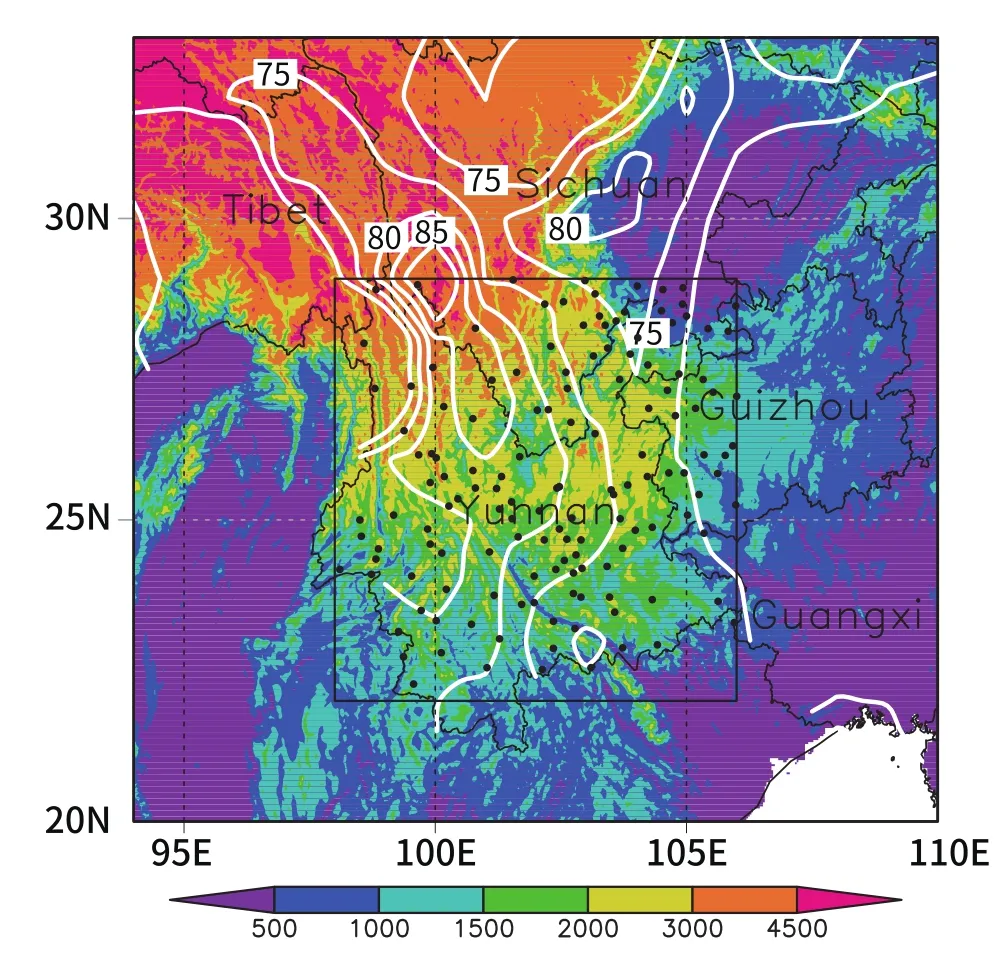
Fig.1.Location of the Southwest China drought region(shaded:surface elevation;units:m)and the wet season(summer and autumn)precipitation proportion to the annual precipitation amount averaged from 1961–2013(contours;units:%).The target area is marked by a rectangle and the 142 rain gauge stations in this area are indicated by black dots.
Drought and floods are the principal meteorological disasters in this region and account for 70%of total economic losses from meteorological disasters(Qin et al.,1997;Cheng et al.,2009).By virtue of the dual challenges of drought and flood,Southwest China is particularly vulnerable to changes in long-term climate variability and anthropogenic climate change.By occurring separately,for example in di ff erent years,both could potentially become more frequent in future.
Increasing precipitation extremes against a drying climate background is a new phenomenon and poses new challenges for climate adaptation and water resources management.Awareness and scientific understanding of these challenges are thus clearly beneficial to policymakers,as well as the general public,for this predominantly rural,relatively poor region of China,heavily dependent on agriculture(Qiu,2010;Wang et al.,2015a).A combined assessment of the dual drought and flood challenges is largely absent in the literature and thus forms a key aim of this paper.Section 2 describes data and methods;section 3 presents the main findings.The whole paper is summarized in section 4 with conclusions.
2.Data and methods
Southwest China is defined here as the geographical area bounded by the rectangle(22◦–29◦N,96◦–106◦E)as shown in Fig.1.This particular region is the focus here in light of recent impacts and its already high vulnerability to natural disasters.Rain gauge data are taken from the National Meteorological Information Center(NMIC),China Meteorological Administration,which runs a nationwide observational network of over 2400 weather stations.There are 142 stations(shown as dotted in Fig.1)in our target region for the years 1971–2013.To describe changes in extreme aspects of this rainfall requires analysis of hourly observations rather than of daily,24-h means used in most studies.Of the 142 stations,61 have hourly observations.Rainfall accumulations were recorded using either siphon or tipping bucket rain gauges up to the year 2000 and automatic meteorological stations thereafter.Daily values were compiled from manual observations of six-hourly accumulations.Both hourly and daily data were quality controlled by the NMIC using extreme value and consistency tests.Further quality control involved a consistency test between the hourly daily and quality-controlled daily data(NMIC,2012,2013;Zhang et al.,2016).The crop areas affected by floods and droughts from 1971 to 2013 were supplied by the Chinese Ministry of Agriculture(http://202.127.42.157/moazzys/zaiqing.aspx).
3.Results
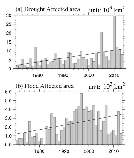
Fig.2.Annual(a)drought-affected and(b) flood-affected crop area(units:103 km2)in Yunnan Province,1971–2013.Black lines show corresponding linear trends.Note:there is no drought-affected crop area data in 1971 and no flood-affected crop area data in 1982.
Figure 2 shows the historical records of crop areas affected by drought(Fig.2a)and floods(Fig.2b)for the period 1971–2013 in Yunnan Province based on annual statistics from the Chinese Ministry of Agriculture.It is clear that impacts from drought have significantly increased during the past 43 years,with the extreme 2009/10 drought(affecting an area about four times greater than that in a normal year)consistent with analysis by Zhang et al.(2013).The drought affected crop area has more than doubled since 1971.In the meantime,the crop area affected by floods has also increased dramatically.For the same period,the flood-affected crop area has increased by 96%,statistically significant at the 1%level(Fig.2b).It is also noted here that the increase in floods has not been as steady as drought,with a strong interdecadal signal.
Figure 3 shows observed annual and wet season(summer and autumn)precipitation accumulations(red and black lines,respectively)area-averaged for Southwest China.A significant(at the 90%level,based on the Student’st-test)decreasing trend in annual total precipitation of 18.2 mm(10 yr)−1is clearly shown.This correlates well(r= −0.37)with the increasing drought occurrence shown in Fig.2a.The wet season rainfall total(black line,of an average 797 mm)accounts for 80%of the annual total.This large contribution is clearly reflected in the consistency between the interannual variability of the annual and wet season totals.The decreasing annual trend is clearly dominated by a similar trend in the wet season[of−18.9 mm(10 yr)−1or−2.4%(10 yr)−1,also significant at the 10%level].
Acleardrying is seen in both the annualtotal and wet sea-son precipitation experience after about 2000,which accelerated the overall trend,and which has attracted some concern(Wang et al.,2015a).Our results support the findings of Xu et al.(2015)and Wang et al.(2015b).Xu et al.(2015)and Wang et al.(2015b)pointed out this rainfall variation and its possible cause over Southwest China in summer and autumn,respectively.Xu et al.(2015)suggested strong contributions to the drying from changes in the northwestern Pacific subtropical and South Asian anticyclones.These key circulation patterns heavily influence water vapor convergence and vertical motion over Southwest China.They also suggested how warming in the tropical Atlantic warming,via wave activity anomalies over Eurasia,could have played a role.There remains,however,much uncertainty regarding the robustness of such mechanisms.
Figure 3 also shows the high contribution to the annual rainfall from that during the wet season.Any increase in dry season rainfall is unlikely to significantly reverse the annual total trend,since rainfall during this season contributes little to the annual total.Most recent studies on Chinese drought have tended to focus on the reasons for winter and spring season droughts in Southwest China.Tan et al.(2017),for example,suggested a role of decadal Arctic Oscillation and El Niño variability as contributors to winter drought.The trends shown above,however,suggest a stronger focus is needed on summer drought trends,whose causes currently remain unexplained.
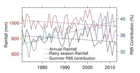
Fig.3.Observed area(22◦–29◦N,96◦–106◦E)averaged wet season(summer and autumn)rainfall(left axis;black line;units:mm),annual mean rainfall(left axis;red line;units:mm)and contributions from the wettest 5%summer hours(right axis;blue line;units:%)during 1971–2013.Dashed lines show corresponding linear trends.
We now consider the wettest 5%of hours,in view of their impacts mentioned earlier.The threshold of the wettest 5%of hours was determined by pooling together all summer hours from the whole period.The blue line in Fig.3 shows the percentage proportion of the summer accumulation from rainfall that fell during the wettest 5%of summer hours since 1971.A significant(at the 90%level)increasing trend is present.A linear upward trend of 1.4%(10 yr)−1is statistically significant at the 10%level.Interestingly,this is of an opposite sign to that of the drying trend in summer season totals,despite both occurring during summer.The opposing trends strongly match those,described earlier,of the drought and flood affected areas in Fig.2.This is a key finding of this study and explains the observed increases in damages from both drought and floods.
In order to ensure that the trends shown in Fig.3 are not dominated by a small subset of stations,Fig.4 shows the spatial distribution of trends in summer rainfall(Fig.4a)and the proportion of total summer rainfall from the wettest 5%of hours(Fig.4b).Decreasing trends of total summer rainfall(significant in the south)are seen from almost all stations in the region.However,similar to what we have seen from Fig.3 above,this trend is contradicted by a positive trend in the contribution to these totals from the wettest 5%of hours(for the stations from which hourly data were available).To examine the extent of this contradiction in terms of the rainfall distribution,the lower panels of Fig.4 show the trends in rainfall totals from hours of low(<2 mm)and high(>20 mm)intensity rainfall.For the low intensity,Fig.4c shows a widespread decreasing trend,particularly in the west,of up to 8 mm(10 yr)−1.The decreasing trend at most stations is statistically significant at the 10%level.In contrast,an increasing trend is seen(Fig.4d)in the high intensity rainfall.
It is also useful to examine how rainfall of differing intensity contributes to the overall total.We do this here by considering categories of contribution to total seasonal rainfall,conditioned on hourly intensity.For this,the hourly intensities were initially ranked from driest to wettest.Then,starting from the driest hour,hours were collated together until their sum of rainfall reached 10%of the seasonal total.The observed trend for this first 10%(“category of contribution conditioned on intensity 1”)was then calculated.The process was then repeated for a further nine,progressively wetter 10%categories.Figure 5 shows the rainfall totals and frequency trends for all 10 categories.
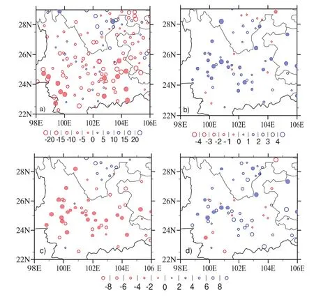
Fig.4.Linear trends[units:mm(10 yr)−1]for the period 1971–2013 of the(a)summer rainfall,(b)proportion of total summer rainfall that fell during the wettest 5%of summer hours,and(c,d)summer rainfall during hours of rainfall intensity(c)<2 mm h−1 and(d)>20 mm h−1.Filled circles denote trends statistically significant at the 10%level.
Decreasing trends dominate the six lightest intensity categories,which summed together account for 60%of the total.For the high intensity categories,increases are seen.Overall,the results suggest that the decreasing low intensity rainfall more than off sets the increase in high intensity rainfall culminating in the decrease in total rainfall.The positive trend in high intensity rainfall,however,suggests a greater risk of flash floods.
The results shown here support similar recent findings in the literature using daily mean observations.For instance,Li et al.(2012)showed significant increasing regional trends in 99th percentile and maximum one-day precipitation values concomitant with shorter periods of consecutive wet days.Chen and Zhai(2014)reported fewer wet days and wet periods of longer than three days but more frequent wet periods of less than three.However,a recent study by Ma et al.(2015)found that almost all precipitation categories showed decreasing trends for both precipitation amount and frequency from 1960–2013 over Southwest China.Taken together with the literature,however,our analysis shows that against the obviously decreasing rainfall background over Southwest China,low intensity events are becoming significantly dryer whilst heavy rainfall intensity events are increasing.
4.Conclusions
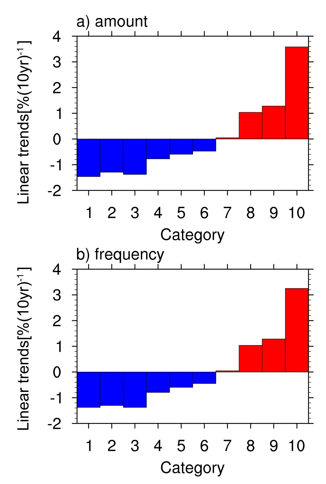
Fig.5.Linear trends[units:%(10 yr)−1],relative to the climatological mean of each category,of observed summer(a)rainfall and(b)frequency for categories of contribution to total rainfall,conditioned on intensity.Each category contributes 10%to the total.Rainfall intensity is smallest for the leftmost categories and greatest for the rightmost.
It is generally expected that global warming will strengthen the hydrological cycle with increased precipitation globally.The increase,however,is highly inhomogeneous,with the tropics and polar regions getting wetter whilst the subtropics are becoming drier.Southwest China,in the subtropics,southeast of the Tibetan Plateau,consequently faces a generally drying future.Annual precipitation is dominated by the wet season and characterized by convective rainfall.Using annual statistical records from the Chinese Ministry of Agriculture,this paper documents an increasing trend of drought and floods.By analyzing high-resolution precipitation observations,the annual and wet season precipitation over Southwest China is shown to have decreased during the period 1971–2013.A significant downward trend[−2.4%(10 yr)−1]is found for the wet season’s rainfall.However,precipitation extremes over the region have increased.Rainfall during the wettest 5%of hours has increased,with a trend of 1.4%(10 yr)−1.Rainfall during hours with at least 20 mm has also shown an increasing trend,at the expense of decreasing low-intensity rainfall.
The combination of decreasing annual and wet season total rainfall with increasing extremes poses an increasing risk of flash floods with a drying climate for the region.If these trends continue in the future,as suggested by Wang et al.(2014)and Wu et al.(2015),based on CMIP5 model projections,policymakers and the general public in the region will have to deal with the dual challenge of not only preparing for drought-related water shortages and agricultural stress,but also increasingly frequent and extreme flash floods and landslides.Further research along this direction is clearly required to build on the findings presented here.This includes improving understanding of the mechanisms,as well as the quantification and reduction of uncertainties,ultimately allowing reliable future climate projections for the region.
Acknowledgements.This work was jointly supported by the National Key R&D Program of China(Grant Nos.2016YFE0102400 and 2017YFC1502701)and the UK–China Research&Innovation Partnership Fund through the Met Office Climate Science for Service Partnership(CSSP)China as part of the Newton Fund.
REFERENCES
Chen,Y.,and P.M.Zhai,2014:Changing structure of wet periods across southwest China during 1961–2012.Climate Research,61,123–131,https://doi.org/10.3354/cr01247.
Cheng,J.G.,H.M.Yan,H.S.Yan,and M.E.Xie,2009:Analysis on Characteristic and Cause of Severe Climate Disaster in Yunnan.China Meteorology Press,250 pp.(in Chinese)
Chou,C.,and J.D.Neelin,2004:Mechanisms of global warming impacts on regional tropical precipitation.J.Climate,17,2688–2701,https://doi.org/10.1175/1520-0442(2004)017<2688:MOGWIO>2.0.CO;2.
Chou,C.,J.D.Neelin,C.A.Chen,and J.Y.Tu,2009:Evaluating the “rich-get-richer”mechanism in tropical precipitation change under global warming.J Climate,22,1982–2005,https://doi.org/10.1175/2008JCLI2471.1.
Dai,A.G.,2012:Increasing drought under global warming in observations and models.Nature Climate Change,3,52–58,https://doi.org/10.1038/nclimate1633.
Huang,R.H.,Y.Liu,L.Wang,and L.Wang,2012:Analyses ofthe causes of severe drought occurring in Southwest China from the fall of 2009 to the spring of 2010.Chinese Journal of Atmospheric Sciences,36(3),443–457,https://doi.org/10.3878/j.issn.1006-9895.2011.11101.(in Chinese with English abstract)
IPCC,2013:Summary for policymakers.T.F.Stocker et al.,Eds.,Climate Change 2013:The Physical Science Basis.Contribution of Working Group I to the Fifth Assessment Report of the Intergovernmental Panel on Climate Change.Cambridge University Press,Cambridge and New York.
Li,Y.H.,H.M.Xu,and D.Liu,2009:Features of the extremely severe drought in the east of Southwest China and anomalies of atmospheric circulation in summer 2006.Acta Meteorologica Sinica,67,122–132,https://doi.org/10.11676/qxxb2009.013.(in Chinese with English abstract)
Li,Z.X.,and Coauthors,2012:Changes of daily climate extremes in southwestern China during 1961–2008.Global and Planetary Change,80-81,255–272,https://doi.org/10.1016/j.gloplacha.2011.06.008.
Ma,S.M.,T.J.Zhou,A.G.Dai,and Z.Y.Han,2015:Observed changes in the distributions of daily precipitation frequency and amount over China from 1960 to 2013.J.Climate,28,6960–6978,https://doi.org/10.1175/JCLI-D-15-0011.1.
NMIC(National Meteorological Information Center),2012:Assessment Report of Chinese national meteorological stations’basic meteorological element daily data sets Version3.0.(in Chinese)
NMIC(National Meteorological Information Center),2013:Quality Assessment Report of Chinese national meteorological stations’hourly precipitation data sets Version1.0.(in Chinese)
Qin,J.,J.H.Ju,and M.E.Xie,1997:Weather&Climate over Low Latitudes Plateau.China Meteorology Press,210 pp.(in Chinese)
Qiu,J.,2010:China drought highlights future climate threats.Nature,465,142–143,https://doi.org/10.1038/465142a.
Sun,L.,F.M.Ren,Z.Y.Wang,Y.Y.Liu,Y.J.Liu,P.L.Wang,and D.Q.Wang,2012:Analysis of climate anomaly and causation in August 2011.Meteorological Monthly,38,615–622.(in Chinese with English abstract)
Tan,H.J.,R.S.Cai,J.L.Chen,and R.H.Huang,2017:Decadal winter drought in Southwest China since the late 1990s and its atmospheric teleconnection.International Journal of Climatology,37,455-467,https://doi.org/10.1002/joc.4718.
Wang,L.,W.Chen,and W.Zhou,2014:Assessment of future drought in Southwest China based on CMIP5 multi model projections.Adv.Atmos.Sci.,31(5),1035–1050,https://doi.org/10.1007/s00376-014-3223-3.
Wang,L.,W.Chen,W.Zhou,and G.Huang,2015a:Drought in Southwest China:A review.Atmospheric and OceanicScience Letters,8,339–344,https://doi.org/10.3878/AOSL 20150043.
Wang,L.,W.Chen,W.Zhou,and G.Huang,2015b:Teleconnected influence of tropical Northwest Pacific sea surface temperature on interannual variability of autumn precipitation in Southwest China.Climate Dyn.,45,2527–2539,https://doi.org/10.1007/s00382-015-2490-8.
Wu,J.,B.T.Zhou,and Y.Xu,2015:Response of precipitation and its extremes over China to warming:CMIP5 simulation and projection.Chinese Journal of Geophysics,58(5),461–473,https://doi.org/10.1002/cjg2.20187.
Wu,P.L.,R.Wood,J.Ridley,and J.Lowe,2010:Temporary acceleration of the hydrological cycle in response to a CO2 rampdown.Geophys.Res.Lett.,37,L12705,https://doi.org/10.1029/2010GL043730.
Xu,Z.Q.,K.Fan,and H.J.Wang,2015:Decadal Variation of Summer Precipitation over China and Associated Atmospheric Circulation afterthe Late 1990s.J.Climate,28,4086–4106,https://doi.org/10.1175/JCLI-D-14-00464.1.
Zhang,M.J.,J.Y.He,B.L.Wang,S.J.Wang,S.S.Li,W.L.Liu,and X.N.Ma,2013:Extreme drought changes in Southwest China from 1960 to 2009.Journal of Geographical Sciences,23(1),3–16,https://doi.org/10.1007/s11442-013-0989-7.
Zhang,Q.,Y.F.Zhao,and S.H.Fan,2016:Development of hourly precipitation datasets for national meteorological stations in China.Torrential Rain and Disasters,35(2),182–186,https://doi.org/10.3969/j.issn.1004-9045.2016.02.011.(in Chinese with English abstract)
杂志排行
Advances in Atmospheric Sciences的其它文章
- Assessing Global Warming Induced Changes in Summer Rainfall Variability over Eastern China Using the Latest Hadley Centre Climate Model HadGEM3-GC2
- Representation of the ENSO Combination Mode and its Asymmetric SST Response in Di ff erent Resolutions of HadGEM3
- Di ff erent Asian Monsoon Rainfall Responses to Idealized Orography Sensitivity Experiments in the HadGEM3-GA6 and FGOALS-FAMIL Global Climate Models
- Indian Ocean SST modes and Their Impacts as Simulated in BCC_CSM1.1(m)and HadGEM3
- On Northern Hemisphere Wave Patterns Associated with Winter Rainfall Events in China
- Effect of Horizontal Resolution on the Representation of the Global Monsoon Annual Cycle in AGCMs
