Precipitation isotopes in the Tianshan Mountains as a key to water cycle in arid central Asia
2018-04-08MingJunZhangShengJieWang
MingJun Zhang , ShengJie Wang ,2*
1. College of Geography and Environmental Science, Northwest Normal University, Lanzhou, Gansu 730070, China
2. State Key Laboratory of Cryospheric Sciences, Northwest Institute of Eco-Environment and Resources, Chinese Academy of Sciences, Lanzhou, Gansu 730000, China
1 Introduction
The Tianshan Mountains (also known as Tien Shan) is a large system of mountain ranges in central Asia. From west to east, the range is approximately 2,500 km in length, and the eastern section (about 1,700 km) is located in Xinjiang, northwestern China.Precipitation amount across the mountains is much higher than that in surrounding low-lying areas and the mountains is considered as a wet island in an arid climate (Zhuet al., 2015). In past decades, the rapid increase in air temperature and precipitation amount across the Tianshan Mountains has greatly influenced local water resources and sustainable development(Chenet al., 2016; Deng and Chen, 2017).
Precipitation is a vital component in the Earth's water cycle, and stable isotope composition in precipitation is of great use in understanding hydrological processes (Zhang and Wang, 2016). Along the Chinese portion of the Tianshan Mountains, precipitation stable isotope studies date back to the 1980s and even earlier (Figure 1 and Table 1). For example, in a one-year nationwide observation of precipitation isotopes in China during 1980, a total of eight meteorological stations were selected, and 13 samples were collected in Urumqi, the provincial capital of Xinjiang (Zhenget al., 1983); in July and August 1981,stable oxygen isotopes in 56 precipitation samples at two alpine sites (>3,500 m a.s.l.) on the northern slope of the Tianshan Mountains were also analyzed(Watanabeet al., 1983).
In the late 1980s, a series of Chinese stations including Urumqi were submitted to the GNIP (Global Network of Isotopes in Precipitation) database which was managed by IAEA (International Atomic Energy Agency) in cooperation with WMO (World Meteorological Organization). Monthly isotope data from the GNIP Urumqi station is available online for 131 months,i.e., 1986-1992, 1995-1998 and 2001-2003(IAEA/WMO, 2017). Similar to the GNIP database,the Chinese Network Isotopes in Precipitation(CHNIP) was established in 2004 to continue a nationwide observation on a monthly basis. The CHNIP Fukang station is generally close to Urumqi, and the precipitation isotopes in Fukang were observed during 2005-2007 and 2009 (Liuet al., 2009, 2014a).
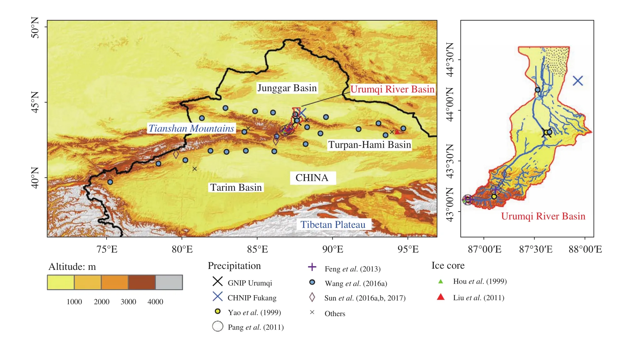
Figure 1 Map showing representative observations of stable isotopes in precipitation and ice cores across the Chinese Tianshan Mountains

Table 1 Representative observations of stable isotopes in precipitation across the Chinese Tianshan Mountains
Except for monthly data of the GNIP and CHNIP databases, event-based precipitation samples were discontinusely collected at the upper and middle reaches of the Urumqi River on the northern slope of the Tianshan Mountains. Along the trunk stream (about 200 km in length) from headwaters to terminal lakes,the altitude difference of about 4,000 m provides a nice platform to investigate precipitation isotopes of arid inland basins. Sampling was carried out at different elevations in recent decades, which are meaningful for examination of meteorological controls on precipitation isotopes in this watershed (e.g., Houet al.,1999; Yaoet al., 1999; Zhanget al., 2003; Panget al.,2011; Fenget al., 2013; Sunet al., 2015; Kong and Pang, 2016). Beside the Urumqi River Basin, the observation is generally limited to an extended period of time.
To improve the knowledge of spatial distribution,as well as controlling a regime of precipitation isotopes in arid central Asia, an observation network was established in 2012 across the Tianshan Mountains(Wanget al., 2016a). More than 20 stations were included in this network which covered typical landscapes from high mountains to low-lying oases and deserts, and more than 1,000 precipitation samples were collected from 2012 to 2013. According to in-situ observations in recent years, the influencing factors on precipitation isotopes in an arid setting were reconsidered, and detailed information (especially moisture recycling, below-cloud evaporation, trajectory and synoptic effects) was discussed using the event-based database (Wanget al., 2016b, 2016c, 2017).
In this paper, we reviewed the core knowledge about stable isotope composition in present-day precipitation around the Tianshan Mountains, which is useful in understanding water cycles and land-atmosphere interaction in arid central Asia.
2 Basic pattern of precipitation isotopes
2.1 Spatial distribution
Spatial patterns of stable isotope ratios across wide geographic areas, which is often termed isoscape (derived from isotope landscape), are increasingly applied in hydrological studies (Bowen and Good, 2015). Zhang and Wang (2016) summarized three main approaches to derive isoscape in China during past decades including 1) simple spatial interpolation, 2) interpolation using spatial and/or climate variables, and 3) isotope-enabled climate model. Logically, spatial details of precipitation isotopes cannot be finely estimated using simple spatial interpolation if only sparse GNIP stations are applied (e.g., Liuet al., 2014b). Figure 2a exhibits synchronous observations at 23 stations across the Tianshan Mountains during 2012-2013 (Wanget al., 2016a), suggesting a complex spatial pattern of precipitation isotopes. In this network, δ18O values (relative to Vienna Standard Mean Ocean Water) in precipitation on the southern slope of the Tianshan Mountains are usually higher than those on the northern slope.
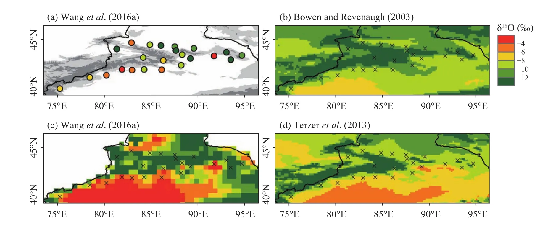
Figure 2 Spatial distribution of annual mean δ18O in precipitation across the Tianshan Mountains.
Using spatial (e.g., longitude, latitude and elevation) and/or climatic (e.g., air temperature, precipitation amount and relative humidity) variables, the isoscape has improved for this region (Liuet al., 2008;Terzeret al., 2013). Figures 2b, 2c, 2d are three examples of interpolation with spatial and climatic variables, and the isotopically enriched southern basin can be simulated. Figure 2b is derived from an empirical model using latitude and elevation which is initially applied to investigate global precipitation isotopes(Bowen and Revenaugh, 2003). In Figure 2c, considering the linear correlation between δ18O and air temperature across the Tianshan Mountains, Wanget al.(2016a) used a 0.5°×0.5° (latitude by longitude) gridded daily database of air temperature and precipitation amount to derive the isoscape. Figure 2d shows an IAEA-developed regionalized cluster-based water isotope prediction (RCWIP) approach (Terzeret al.,2013) which is based on climatically similar subsets of the GNIP database and related data. Compared with methods relying only on geographical parameters such as latitude and elevation, the interpolation procedure with climatic variables may be beneficial in examining temporal variability.
In recent decades, isotope-enabled GCMs (general circulation models) have aroused increased attention in stable water isotope studies (Sturmet al.,2010; Galewskyet al., 2016). In some high-resolution simulations using isotope-enabled GCMs (e.g.,Yaoet al., 2013), isotopically depleted areas can be detected at high elevations of the Tianshan Mountains. However, if the spatial resolution is not very high, the Tianshan Mountains may not be easily identified (Wanget al., 2015a; Cheet al., 2016; Yanget al., 2017). Similarly, remote sensing-derived stable isotopes of water vapor (Liuet al., 2014b; Heet al.,2015) exhibited the difference between the northern and southern slopes of the Tianshan Mountains, but the mountain ranges cannot be clearly seen in many cases.
Because of the linear relationship between hydrogen and oxygen isotopes in the study region, the spatial pattern of hydrogen isotopes is similar to that of oxygen isotopes. However, as exhibited in Wanget al. (2016a), the distribution of D-excess (d=δD-8δ18O; Dansgaard, 1964) is complex in arid central Asia (Figure 3). The spatial pattern of D-excess seems difficult to model based on simulated results from varied empirical models (Bowen and Revenaugh,2003; Terzeret al., 2013) and isotope-equipped GCMs (Cheet al., 2016).
2.2 Seasonal variation
Regarding the seasonal variation of stable isotopes in precipitation of arid central Asia, almost all the observations (e.g., Fenget al., 2013; Wanget al.,2016a) indicated that stable isotopes are enriched in summer months and depleted in winter months. As presented in Figures 4a and 4b, the seasonal variations in δ18O at 23 stations during 2012-2013 generally coincide with those at the GNIP Urumqi Station from the 1980s to the 2000s, but wider spatial coverage shows larger fluctuations in this region. The seasonal variability of stable isotope ratios in precipitation can be well simulated using regression models in the geographic information system (GIS) and isotope-enabled GCMs (Yaoet al., 2013; Wanget al.,2015a). According to isotope-enabled GCM simulations across the Tianshan Mountains (Wanget al.,2015a), seasonal variability is generally similar for different sub-regions, although the northern slope (and eastern section) is more isotopically depleted than the southern slope (and western section). As for deuterium excess (Figures 4c and 4d), seasonal characteristics is complex in the study region. If the event-based samples during 2012-2013 (Wanget al., 2016a) are taken into account, there is no seasonal coherence for deuterium excess in precipitation, which cannot be well represented by only the GNIP Urumqi Station.
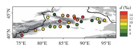
Figure 3 Spatial distribution of annual mean deuterium excess in precipitation across the Tianshan Mountains during 2012-2013 based on data from Wang et al. (2016a)
2.3 Inter-annual variation
Among all the in-situ observations of stable isotope in present-day precipitation across the Tianshan Mountains, the GNIP Urumqi Station (IAEA/WMO,2017) has a relatively long and discontinuous history from 1986 to 2003, and the nearby CHNIP Fukang Station (Liuet al., 2014a) from 2005 to 2009 is sometimes used for comparison (Figure 5a). The headwaters of the Urumqi River has been mentioned in many short-term observations (Table 1), but there is no compiled analysis because of different observation sites, sampling procedures and analytical instruments as well as data availability for these discontinuous periods. A reconstructed series of precipitation δ18O in Urumqi based on temperature effect are presented in Figure 5a. Besides present-day precipitation, stable isotope ratios in ice cores (Figure 5b) were reported at some sites along the Tianshan Mountains such as the Miao'ergou Ice Cap (Liuet al., 2011). In addition, the annual series of δ18O simulated by isotope-enabled GCMs in arid northwest China from 1979 to 2007 (Yanget al., 2017) are presented in Figures 5c, 5d, 5e.
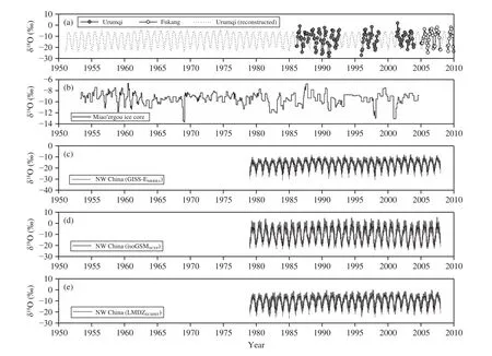
Figure 5 Inter-annual variation of δ18O in precipitation across the Tianshan Mountains in past decades. (a) GNIP Urumqi(IAEA/WMO, 2017) and CHNIP Fukang stations (Liu et al., 2014a); (b) The Miao'ergou ice core (Liu et al., 2011);(c-e) Northwest China simulation using isotope-enabled GCMs (Yang et al., 2017)
3 Environmental information of precipitation isotopes
3.1 Temperature effect
The temperature effect of precipitation isotopes in arid central Asia has been widely accepted in many observations (Yaoet al., 1999, 2013; Wanget al.,2016a). According to event-based and monthly samples collected in this region, δ18O values usually positively correlates with local air temperature (Figure 6).As presented in Figure 6a, if the event-based samples during 2012-2013 (Wanget al., 2016a) are considered, the temperature effect can be expressed as δ18O=0.78T-16.01 (whereTis air temperature in °C;r2=0.73,n=1,052), and the δ18O/Tgradients vary from 0.54‰/°C (Aksu) to 1.14‰/°C (Hami). Figure 6b shows the temperature effect on a monthly basis using the GNIP Urumqi Station (IAEA/WMO, 2017),and a strong liner correlation (r2=0.73) can also be evidenced.
If the temperature effect can be applied to climate proxies, it is of great importance in paleoclimate research across arid central Asia. Knowledge about climatic controls on precipitation isotopes is considered as a crucial base for ice core studies in High Asia as well as the Tibetan Plateau (Tian and Yao, 2016). In eastern Pamirs of central Asia, annual variabilities in δ18O of ice cores are in good agreement with air temperature at nearby meteorological stations (r=0.67),showing isotope ratios in ice cores as a temperature indicator in central Asia (Tianet al., 2006). Because of the different condensation conditions for snowfall and rainfall, the temperature effect for the two phases were considered. In two alpine stations at the upper reaches of the Urumqi River (Panget al., 2011), the gradient between isotope ratio and temperature of rainfall is larger than that of snowfall. However, if more stations were involved (Wanget al., 2016a), the temperature effect of snow and rain can be expressed as δ18O=0.68T-17.38 (n=208) and δ18O=0.67T-14.05(n=813), respectively, and there is no significant difference in slopes between solid and liquid precipitation samples.
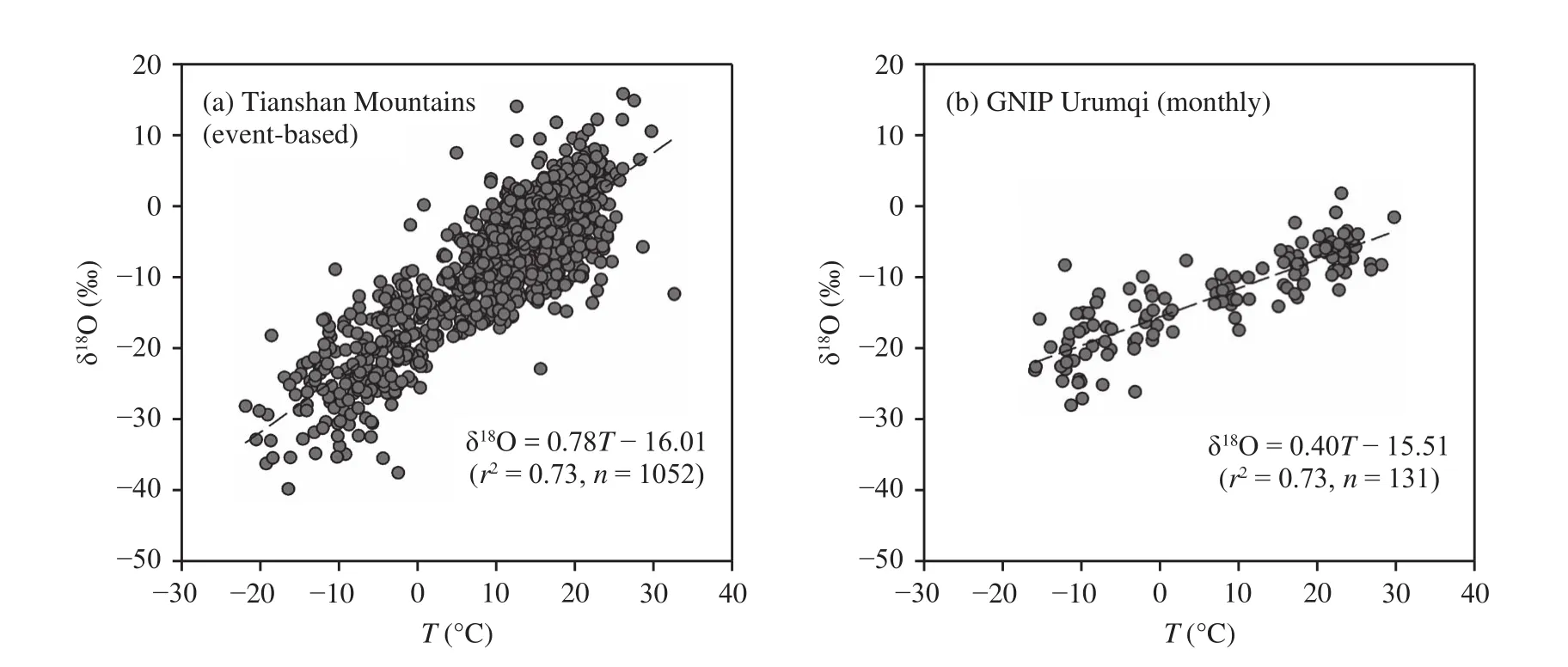
Figure 6 Correlation between air temperature and precipitation δ18O across the Tianshan Mountains based on data from Wang et al. (2016a) and IAEA/WMO (2017)
The temperature effect in arid central Asia can be well simulated by isotope-equipped GCMs (e.g., Yaoet al., 2013). Yanget al. (2017) analyzed the inter-annual variability of GCM-simulated isotope composition in China, and found a strong linear relationship between isotope ratio and air temperature during 1979-2007; the regional mean δ18O in arid northwest China showed an increasing trend between 0.09‰and 0.57‰ per decade depending on GCMs, which generally coincided with the warming trend.
3.2 Trajectory and circulation effect
For some coastal sites, stable isotopes in precipitation are usually applied to identify moisture sources(Crawfordet al., 2013). In the Tianshan Mountains of arid central Asia, the seasonal characteristic of stable isotopes enriched in summer months and depleted in winter months is usually accepted to reflect dominance of the westerlies, which is in contrast with the isotopically depleted summer in southern Tibetan Plateau dominated by Indian monsoons (Tianet al.,2007; Yaoet al., 2013). This isotope-based finding is supported by global reanalysis (Wanget al., 2015a,2016b). As presented in Wanget al. (2017), westerly moisture can be seen all year round in the Tianshan Mountains; the moisture transport in summer is much stronger than that in winter, and moisture path on the northern slope is more fluent than that on the southern slope. The spatial pattern of stable isotopes in precipitation coincides with the air regime for the two slopes of the Tianshan Mountains.
The Lagrangian approaches, especially HYSPLIT(NOAA Hybrid Single-Particle Lagrangian Integrated Trajectory model; Steinet al., 2015) including both online and offline versions, are often applied to verify the isotope-based moisture paths. A specific humidity-adjusted HYSPLIT model (Sodemannet al.,2008; Crawfordet al., 2013) has attracted increased attention in recent years, and meteorological parameters (especially specific humidity) along the back trajectory can be considered to diagnose potential moisture sources (Figure 7). The adjusted trajectories in arid central Asia (Wanget al., 2017) indicates that the northern and southern slope sites of the Tianshan Mountains have slightly different paths, and the depleted isotopes on the northern slope are related to the northerly path of the westerly moisture. Various starting heights and specific humidity thresholds were tested, indicating that the adjusted approach of Wanget al. (2017) can be applied to the trajectory diagnose in arid central Asia. It should be mentioned that al-though the westerly moisture is dominant, monsoon moisture from the Indian Ocean cannot be totally ignored especially in precipitation extremes which is evidenced by meteorological observations (e.g.,Zhanget al., 2014).
Based on GNIP stations, Liuet al. (2015) found a weak negative correlation between precipitation δ18O and air temperature at Urumqi on an annual basis,which may be of interest in paleoclimate studies usually using annual and even decadal data; also, the variabilities in stable isotopes in precipitation were attributed to the northward and southward shifts of westerlies in this region. In addition, the stalagmitebased δ18O record from the Kesang Cave in the Tianshan Mountains has been applied to examine climate change in the Holocene (Chenget al., 2012, 2016; Caiet al., 2017; Zhanget al., 2017). However, more studies are needed to verify the dominant effect during different periods.
3.3 Moisture recycling
Within a terrestrial region, water vapor in the atmosphere originates from external sources or local evapotranspiration. Moisture from local sources,called recycled moisture, plays an important role in the hydrological cycle and land-atmosphere interaction. In arid central Asia with vast desert areas, the absolute amount of actual evapotranspiration is logically limited, but the relative contribution to local precipitation is not always limited (Huaet al., 2017).Considering the high evaporation capacity in central Asia, evapotranspiration from surface water (reservoir, canal and lake) and soil/vegetation (agricultural land and urban green space) cannot be ignored (Konget al., 2013; Wenet al., 2016).
In a three-component mixing model (Phillips and Gregg, 2001; Penget al., 2011), if the isotope compositions in moisture of advection, surface evaporation and transpiration are measured or estimated, the proportional contribution as well as its uncertainty for each end-member can be resolved. Along the trajectory from Yining to Shihezi and then to Caijiahu/Urumqi on the northern slope of the Tianshan Mountains (Wanget al., 2016b), the contribution of recycled moisture is up to 16.2% in Urumqi (including 5.9% of surface evaporation and 10.3% of transpiration), but the contribution is less than 5% in Shihezi and Caijiahu (Figure 8). The influence of transpiration on local precipitation is much larger than that of surface evaporation over these oases of arid central Asia. The results are generally similar to other studies (Liet al., 2016a, 2016b) in arid and semi-arid lands.
Recent efforts have focused on the uncertainty and improvement of stable isotope mixing models in an arid setting. Wanget al. (2016b) applied an adjusted method without assumption of isotopic equilibrium(Skrzypeket al., 2015) to estimate isotope composition in precipitating vapor, and this method was evidenced to be better than traditional procedures (Cuiet al., 2017). As presented in Figure 8, a standard error as well as a 95% confidential interval of proportional contribution for each component is also useful to assess model uncertainty (Wanget al., 2016b). Regarding the stable isotope composition of transpiration moisture that cannot be measured for most areas, the impact of commonly-used approximation using precipitation isotopes were discussed (Wanget al.,2016b). More field samplings of plant xylem (Liet al., 2016a, 2016b) seems to be a workable solution to resolve this issue, but xylem isotopes usually present a large variability for different seasons and species in central Asia (Wuet al., 2014; Daiet al., 2015; Zhouet al., 2015). To improve the model, more experiments are still needed.

Figure 8 Proportional contribution of transpiration, surface evaporation and advection to local precipitation across the Tianshan Mountains based on data from Wang et al. (2016b)
3.4 Below-cloud evaporation
In an unsaturated atmosphere, falling raindrops from cloud base to ground are subjected to evaporation, which is known as below-cloud evaporation or subcloud evaporation. In an arid setting, below-cloud evaporation may greatly reduce the raindrop mass and then influence the isotope composition in raindrops(Salamalikiset al., 2016). Changes in meteoric water lines and isotope ratios under different meteorological conditions (e.g., rainfall intensity, air temperature,relative humidity and precipitation type) can reflect the below-cloud evaporation intensity (Chenet al., 2015).
Based on experiments in Stewart (1975), a series of modified Stewart models have been developed to quantify changes in stable isotopes from cloud base to ground (e.g., Froehlichet al., 2008; Konget al., 2013;Liet al., 2016c; Salamalikiset al., 2016; Wanget al.,2016c). According to in-situ observations at 23 stations across the Tianshan Mountains, Wanget al.(2016c) calculated the difference of deuterium excess in falling raindrops below-cloud base, and the evaporated proportions of raindrop for each station were also derived. As presented in Figure 9a, because of climate backgrounds of different natural zones, the impact of below-cloud evaporation on the southern slope is larger than that on the northern slope. The sensitivity test of isotope changes under different meteorological situations shows that the southern slope is more sensitive to air temperature and relative humidity(Wanget al., 2016c). After the correction of belowcloud evaporation, the spatial coherence of stable isotopes for neighboring stations is improved (Wanget al., 2016c), indicating that the below-cloud evaporation should be carefully considered in hydrological studies of arid regions.
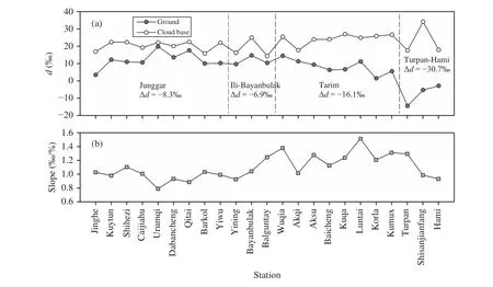
Figure 9 Variation of (a) deuterium excess from cloud base to ground during summer months and (b) linear gradient between differences in deuterium excess and evaporation proportion of raindrops across the Tianshan Mountains based on data from Wang et al. (2016c)
Some studies were interested in the relationship between the evaporation ratio of raindrop and the difference in deuterium excess from cloud base to ground (Zhang and Wang, 2016). A gradient of approximately 1‰/% (changes in deuterium excess per mil when evaporated proportion changes by 1%) was derived from European mountains using a modified Stewart model (Froehlichet al., 2008), and the empirical parameter has been directly applied to other areas(e.g., Penget al., 2010; Chenet al., 2015). However,more recent studies indicated a wide fluctuation of gradient from about 0.8‰/% to about 1.5‰/% under various meteorological conditions (Salamalikiset al.,2016; Wanget al., 2016c). Figure 9b shows the gradient for each station across the Tianshan Mountains during 2012-2013 (Wanget al., 2016c), and in a relatively humid and cool environment, the gradient is usually low.
4 Perspectives
As a typical wet island in arid central Asia, the Tianshan Mountains has attracted a great deal of attention in stable water isotope studies, especially precipitation isotope studies. In past decades, based on a series of in-situ observations and simulations across the Tianshan Mountains, our knowledge about stable water isotopes of arid central Asia has been gradually updated. For future work, we should focus on the three directions presented below:
(1) Synoptic-scale diagnose of precipitation isotopes. Although many event-based samplings have been operated in central Asia, the integrated study linking synoptic processes and precipitation isotopes is still very limited. The evaporation, exchange and condensation processes affecting precipitation can be examined using stable isotopes at synoptic scale. Detailed information in stable isotope compositions of precipitation may be useful to diagnose moisture transport and rainfall formation.
(2) Linkage between paleoclimate and modern observations. In different temporal scales, the environmental controls on isotopes in precipitation may be not consistent, and the importance of temperature effect and circulation effect has been included in paleoclimate studies. The observations of present-day precipitation are important to detect the controlling factors, but are not always enough to understand paleoclimate. The factors influencing stable isotopes in paleoclimate records and modern precipitation should be carefully considered in future observations and simulations.
(3) Stable isotopes in water vapor and precipitation. Compared with precipitation isotopes, stable isotopes in water vapor can provide continuous information for any weather conditions. The laser-based water vapor isotope analyzer is helpful to investigate the relationship between water vapor and precipitation.Remote sensing products as well as isotope-enabled GCMs may also be of great value on this issue. With multiple data sources from observations and simulations, the water cycle can be examined in depth in the future.
Acknowledgement:
This research is supported by the National Natural Science Foundation of China (Nos. 41771035 and 41161012), Northwest Normal University (No.NWNU-LKQN-15-8) and State Key Laboratory of Cryospheric Sciences (No. SKLCS-OP-2017-04).
Bowen GJ, Revenaugh J, 2003. Interpolating the isotopic composition of modern meteoric precipitation. Water Resources Research,39(10): 1299. DOI: 10.1029/2003WR002086.
Bowen GJ, Good SP, 2015. Incorporating water isoscapes in hydrological and water resource investigations. Wiley Interdisciplinary Reviews: Water, 2(2): 107-119. DOI: 10.1002/wat2.1069.
Cai YJ, Chiang JCH, Breitenbach SFM,et al., 2017. Holocene moisture changes in western China, Central Asia, inferred from stalagmites. Quaternary Science Reviews, 158: 15-28. DOI:10.1016/j.quascirev.2016.12.014.
Che YJ, Zhang MJ, Wang SJ,et al., 2016. Stable water isotopes of precipitation in China simulated by SWING2 models. Arabian Journal of Geosciences, 9(19): 732. DOI: 10.1007/s12517-016-2755-5.
Chen FL, Zhang MJ, Wang SJ,et al., 2015. Relationship between subcloud secondary evaporation and stable isotopes in precipitation of Lanzhou and surrounding area. Quaternary International, 380-381:68-74. DOI: 10.1016/j.quaint.2014.12.051.
Chen X, 2010. Physical Geography of Arid Land in China. Beijing:Science Press. (in Chinese)
Chen YN, Li WH, Deng HJ,et al., 2016. Changes in Central Asia’s water tower: past, present and future. Scientific Reports, 6: 35458.DOI: 10.1038/srep35458.
Cheng H, Zhang PZ, Spötl C,et al., 2012. The climatic cyclicity in semiarid-arid central Asia over the past 500,000 years. Geophysical Research Letters, 39(1): L01705. DOI: 10.1029/2011GL050202.
Cheng H, Spötl C, Breitenbach SFM,et al., 2016. Climate variations of Central Asia on orbital to millennial timescales. Scientific Reports,6: 36975. DOI: 10.1038/srep36975.
Crawford J, Hughes CE, Parkes SD, 2013. Is the isotopic composition of event based precipitation driven by moisture source or synoptic scale weather in the Sydney Basin, Australia? Journal of Hydrology, 507: 213-226. DOI: 10.1016/j.jhydrol.2013.10.031.
Cui JP, Tian LD, Biggs TW,et al., 2017. Deuterium-excess determination of evaporation to inflow ratios of an alpine lake: implications for water balance and modeling. Hydrological Processes, 31(5):1034-1046. DOI: 10.1002/hyp.11085.
Dai Y, Zheng XJ, Tang LS,et al., 2015. Stable oxygen isotopes reveal distinct water use patterns of twoHaloxylonspecies in the Gurbantonggut Desert. Plant and Soil, 389(1-2): 73-87. DOI:10.1007/s11104-014-2342-z.
Dansgaard W, 1964. Stable isotopes in precipitation. Tellus, 16(4):436-468. DOI: 10.3402/tellusa.v16i4.8993.
Deng HJ, Chen YN, 2017. Influences of recent climate change and human activities on water storage variations in Central Asia. Journal of Hydrology, 544: 46-57. DOI: 10.1016/j.jhydrol.2016.11.006.
Feng F, Li ZQ, Zhang MJ,et al., 2013. Deuterium and oxygen 18 in precipitation and atmospheric moisture in the upper Urumqi River Basin, eastern Tianshan Mountains. Environmental Earth Sciences,68(4): 1199-1209. DOI: 10.1007/s12665-012-1820-y.
Froehlich K, Kralik M, Papesch W,et al., 2008. Deuterium excess in precipitation of Alpine regions-moisture recycling. Isotopes in Environmental and Health Studies, 44(1): 61-70. DOI:10.1080/10256010801887208.
Galewsky J, Steen-Larsen HC, Field RD,et al., 2016. Stable isotopes in atmospheric water vapor and applications to the hydrologic cycle. Reviews of Geophysics, 54(4): 809-865. DOI:10.1002/2015RG000512.
He Y, Risi C, Gao J,et al., 2015. Impact of atmospheric convection on south Tibet summer precipitation isotopologue composition using a combination of in situ measurements, satellite data, and atmospheric general circulation modeling. Journal of Geophysical Research:Atmospheres, 120(9): 3852-3871. DOI: 10.1002/2014JD022180.
Hijmans RJ, Cameron SE, Parra JL,et al., 2005. Very high resolution interpolated climate surfaces for global land areas. International Journal of Climatology, 25(15): 1965-1978. DOI: 10.1002/joc.1276.
Hou SG, Qin DH, Mayewski PA,et al., 1999. Climatological significance of δ18O in precipitation and ice cores: a case study at the head of the Ürümqi river, Tien Shan, China. Journal of Glaciology,45(151): 517-523. DOI: 10.1017/S0022143000001374.
Hua LJ, Zhong LH, Ke ZJ, 2017. Characteristics of the precipitation recycling ratio and its relationship with regional precipitation in China. Theoretical and Applied Climatology, 127(3-4): 513-531.DOI: 10.1007/s00704-015-1645-1.
IAEA/WMO (International Atomic Energy Agency/World Meteorological Organization), 2017. Global Network of Isotopes in Precipitation (GNIP). 2017-11-21. http://www-naweb.iaea.org/napc/ih/IHS_resources_gnip.html.
Kong YL, Pang ZH, Froehlich K, 2013. Quantifying recycled moisture fraction in precipitation of an arid region using deuterium excess. Tellus B: Chemical and Physical Meteorology, 65(1): 19251.DOI: 10.3402/tellusb.v65i0.19251.
Kong YL, Pang ZH, 2016. A positive altitude gradient of isotopes in the precipitation over the Tianshan Mountains: effects of moisture recycling and sub-cloud evaporation. Journal of Hydrology, 542:222-230. DOI: 10.1016/j.jhydrol.2016.09.007.
Li ZX, Feng Q, Wang QJ,et al., 2016a. Contributions of local terrestrial evaporation and transpiration to precipitation using δ18O and D-excess as a proxy in Shiyang inland river basin in China. Global and Planetary Change, 146: 140-151. DOI: 10.1016/j.gloplacha.2016.10.003.
Li ZX, Feng Q, Wang QJ,et al., 2016b. The influence from the shrinking cryosphere and strengthening evopotranspiration on hydrologic process in a cold basin, Qilian Mountains. Global and Planetary Change, 144: 119-128. DOI: 10.1016/j.gloplacha.2016.06.017.
Li ZX, Feng Q, Wang YM,et al., 2016c. Effect of sub-cloud evaporation on the δ18O of precipitation in Qilian Mountains and Hexi Corridor, China. Sciences in Cold and Arid Regions, 8(5): 378-387.DOI: 10.3724/SP.J.1226.2016.00378.
Liu JR, Song XF, Sun XM,et al., 2009. Isotopic composition of precipitation over arid Northwestern China and its implications for the water vapor origin. Journal of Geographical Sciences, 19(2):164-174. DOI: 10.1007/s11442-009-0164-3.
Liu JR, Song XF, Yuan GF,et al., 2014a. Stable isotopic compositions of precipitation in China. Tellus B: Chemical and Physical Meteorology, 66(1): 22567. DOI: 10.3402/tellusb.v66.22567.
Liu XK, Rao ZG, Zhang XJ,et al., 2015. Variations in the oxygen isotopic composition of precipitation in the Tianshan Mountains region and their significance for the Westerly circulation. Journal of Geographical Sciences, 25(7): 801-816. DOI: 10.1007/s11442-015-1203-x.
Liu YP, Hou SG, Hong S,et al., 2011. High-resolution trace element records of an ice core from the eastern Tien Shan, central Asia,since 1953 AD. Journal of Geophysical Research: Atmospheres,116(D12): D12307. DOI: 10.1029/2010JD015191.
Liu ZF, Tian LD, Chai XR,et al., 2008. A model-based determination of spatial variation of precipitation δ18O over China. Chemical Geology, 249(1-2): 203-212. DOI: 10.1016/j.chemgeo.2007.12.011.
Liu ZF, Yoshimura K, Kennedy CD,et al., 2014b. Water vapor δD dynamics over China derived from SCIAMACHY satellite measurements. Science China Earth Sciences, 57(4): 813-823. DOI:10.1007/s11430-013-4687-1.
Pang ZH, Kong YL, Froehlich K,et al., 2011. Processes affecting isotopes in precipitation of an arid region. Tellus B: Chemical and Physical Meteorology, 63(3): 352-359. DOI: 10.1111/j.1600-0889.2011.00532.x.
Peng TR, Wang CH, Huang CC,et al., 2010. Stable isotopic characteristic of Taiwan's precipitation: a case study of western Pacific monsoon region. Earth and Planetary Science Letters, 289(3-4):357-366. DOI: 10.1016/j.epsl.2009.11.024.
Peng TR, Liu KK, Wang CH,et al., 2011. A water isotope approach to assessing moisture recycling in the island-based precipitation of Taiwan: a case study in the western Pacific. Water Resources Research, 47(8): W08507. DOI: 10.1029/2010WR009890.
Phillips DL, Gregg JW, 2001. Uncertainty in source partitioning using stable isotopes. Oecologia, 127(2): 171-179. DOI:10.1007/s004420000578.
Salamalikis V, Argiriou AA, Dotsika E, 2016. Isotopic modeling of the sub-cloud evaporation effect in precipitation. Science of the Total Environment, 544: 1059-1072. DOI: 10.1016/j.scitotenv.2015.11.072.
Skrzypek G, Mydłowski A, Dogramaci S,et al., 2015. Estimation of evaporative loss based on the stable isotope composition of water usingHydrocalculator. Journal of Hydrology, 523: 781-789. DOI:10.1016/j.jhydrol.2015.02.010.
Sodemann H, Schwierz C, Wernli H, 2008. Interannual variability of Greenland winter precipitation sources: Lagrangian moisture diagnostic and North Atlantic Oscillation influence. Journal of Geophysical Research: Atmospheres, 113(D3): D03107. DOI:10.1029/2007JD008503.
Stein AF, Draxler RR, Rolph GD,et al., 2015. NOAA's HYSPLIT atmospheric transport and dispersion modeling system. Bulletin of the American Meteorological Society, 96(12): 2059-2077. DOI:10.1175/BAMS-D-14-00110.1.
Stewart MK, 1975. Stable isotope fractionation due to evaporation and isotopic exchange of falling waterdrops: applications to atmospheric processes and evaporation of lakes. Journal of Geophysical Research, 80(9): 1133-1146. DOI: 10.1029/JC080i009p01133.
Sturm C, Zhang Q, Noone D, 2010. An introduction to stable water isotopes in climate models: benefits of forward proxy modelling for paleoclimatology. Climate of the Past, 6(1): 115-129. DOI:10.5194/cp-6-115-2010.
Sun CJ, Li WH, Chen YN,et al., 2015. Isotopic and hydrochemical composition of runoff in the Urumqi River, Tianshan Mountains,China. Environmental Earth Sciences, 74(2): 1521-1537. DOI:10.1007/s12665-015-4144-x.
Sun CJ, Chen YN, Li WH,et al., 2016a. Isotopic time series partitioning of streamflow components under regional climate change in the Urumqi River, Northwest China. Hydrological Sciences Journal,61(8): 1443-1459. DOI: 10.1080/02626667.2015.1031757.
Sun CJ, Yang J, Chen YN,et al., 2016b. Comparative study of streamflow components in two inland rivers in the Tianshan Mountains,Northwest China. Environmental Earth Sciences, 75(9): 727. DOI:10.1007/s12665-016-5314-1.
Sun CJ, Shen YJ, Chen YN,et al., 2018. Quantitative evaluation of the rainfall influence on streamflow in an inland mountainous river basin within Central Asia. Hydrological Sciences Journal, 63(1):17-30. DOI: 10.1080/02626667.2017.1390314.
Terzer S, Wassenaar LI, Araguás-Araguás LJ,et al., 2013. Global isoscapes for δ18O and δ2H in precipitation: improved prediction using regionalized climatic regression models. Hydrology and Earth System Sciences, 17(11): 4713-4728. DOI: 10.5194/hess-17-4713-2013.
Tian LD, Yao TD, Li Z,et al., 2006. Recent rapid warming trend revealed from the isotopic record in Muztagata ice core, eastern Pamirs. Journal of Geophysical Research: Atmospheres, 111(D13):D13103. DOI: 10.1029/2005JD006249.
Tian LD, Yao TD, MacClune K,et al., 2007. Stable isotopic variations in west China: a consideration of moisture sources. Journal of Geophysical Research: Atmospheres, 112(D10): D10112. DOI:10.1029/2006JD007718.
Tian LD, Yao TD, 2016. High-resolution climatic and environmental records from the Tibetan Plateau ice cores. Chinese Science Bulletin, 61(9): 926-937. DOI: 10.1360/N972015-00779. (in Chinese)
Wang SJ, Zhang MJ, Chen FL,et al., 2015a. Comparison of GCM-simulated isotopic compositions of precipitation in arid Central Asia. Journal of Geographical Sciences, 25(7): 771-783. DOI:10.1007/s11442-015-1201-z.
Wang SJ, Zhang MJ, Hughes CE,et al., 2016a. Factors controlling stable isotope composition of precipitation in arid conditions: an observation network in the Tianshan Mountains, Central Asia. Tellus B: Chemical and Physical Meteorology, 68(1): 26206. DOI:10.3402/tellusb.v68.26206.
Wang SJ, Zhang MJ, Che YJ,et al., 2016b. Contribution of recycled moisture to precipitation in oases of arid Central Asia: a stable isotope approach. Water Resources Research, 52(4): 3246-3257. DOI:10.1002/2015WR018135.
Wang SJ, Zhang MJ, Che YJ,et al., 2016c. Influence of below-cloud evaporation on deuterium excess in precipitation of arid Central Asia and its meteorological controls. Journal of Hydrometeorology,17(7): 1973-1984. DOI: 10.1175/JHM-D-15-0203.1.
Wang SJ, Zhang MJ, Crawford J,et al., 2017. The effect of moisture source and synoptic conditions on precipitation isotopes in arid central Asia. Journal of Geophysical Research: Atmospheres,122(5): 2667-2682. DOI: 10.1002/2015JD024626.
Wang XY, Li ZQ, Tayier R,et al., 2015b. Characteristics of atmospheric precipitation isotopes and isotopic evidence for the moisture origin in Yushugou River basin, Eastern Tianshan Mountains,China. Quaternary International, 380-381: 106-115. DOI:10.1016/j.quaint.2014.12.023.
Watanabe O, Wu XL, Ikegami K,et al., 1983. Oxygen isotope characteristics of glaciers in the eastern Tian Shan. Journal of Glaciology and Cryopedology, 5(3): 101-112.
Wen XF, Yang B, Sun XM,et al., 2016. Evapotranspiration partitioning through in-situ oxygen isotope measurements in an oasis cropland. Agricultural and Forest Meteorology, 230-231: 89-96. DOI:10.1016/j.agrformet.2015.12.003.
Wu Y, Zhou H, Zheng XJ,et al., 2014. Seasonal changes in the water use strategies of three co-occurring desert shrubs. Hydrological Processes, 28(26): 6265-6275. DOI: 10.1002/hyp.10114.
Yang S, Zhang MJ, Wang SJ,et al., 2017. Interannual trends in stable oxygen isotope composition in precipitation of China during 1979-2007: spatial incoherence. Quaternary International, 454: 25-37.DOI: 10.1016/j.quaint.2017.07.029.
Yao TD, Masson V, Jouzel J,et al., 1999. Relationships between δ18O in precipitation and surface air temperature in the Urumqi River Basin, East Tianshan Mountains, China. Geophysical Research Letters, 26(23): 3473-3476. DOI: 10.1029/1999GL006061.
Yao TD, Masson-Delmotte V, Gao J,et al., 2013. A review of climatic controls on δ18O in precipitation over the Tibetan Plateau: observations and simulations. Reviews of Geophysics, 51(4): 525-548.DOI: 10.1002/rog.20023.
Zhang JL, Wei RQ, Yang L, 2014. Comparison of precipitation area and intensity of two rare heavy rainfall area and intensity over Southern Xinjiang in 2013. Desert and Oasis Meteorology, 8(5):1-9. DOI: 10.3969/j.issn.1002-0799.2014.05.001. (in Chinese)
Zhang MJ, Wang SJ, 2016. A review of precipitation isotope studies in China: basic pattern and hydrological process. Journal of Geographical Sciences, 26(7): 921-938. DOI: 10.1007/s11442-016-1307-y.
Zhang XJ, Jin LY, Chen J,et al., 2017. Detecting the relationship between moisture changes in arid central Asia and East Asia during the Holocene by model-proxy comparison. Quaternary Science Reviews, 176: 36-50. DOI: 10.1016/j.quascirev.2017.09.012.
Zhang XP, Yao TD, Liu JM, 2003. Oxygen-18 in different waters in Urumqi River Basin. Journal of Geographical Sciences, 13(4):438-446.
Zheng SH, Hou FG, Ni BL, 1983. Research on stable hydrogen and oxygen isotopes in precipitation of China. Chinese Science Bulletin, 28(13): 801-806. DOI: 10.1360/csb1983-28-13-801.(in Chinese)
Zhou H, Zhao WZ, Zheng XJ,et al., 2015. Root distribution ofNitraria sibiricawith seasonally varying water sources in a desert habitat.Journal of Plant Research, 128(4): 613-622. DOI: 10.1007/s10265-015-0728-5.
Zhu XF, Zhang MJ, Wang SJ,et al., 2015. Comparison of monthly precipitation derived from high-resolution gridded datasets in arid Xinjiang, central Asia. Quaternary International, 358: 160-170.DOI: 10.1016/j.quaint.2014.12.027.
杂志排行
Sciences in Cold and Arid Regions的其它文章
- From highly polluted inland city of China to "Lanzhou Blue":The air-pollution characteristics
- High-resolution mass spectrometric characterization of dissolved organic matter from warm and cold periods in the NEEM ice core
- Applicability of an ultra-long-range terrestrial laser scanner to monitor the mass balance of Muz Taw Glacier,Sawir Mountains, China
- Comparative study of probable maximum precipitation and isohyetal maps for mountainous regions, Pakistan
- Effects of freeze-thaw cycles on soil N2O concentration and flux in the permafrost regions of the Qinghai-Tibetan Plateau
- An improvement of soil temperature simulations on the Tibetan Plateau
