Progress in the investigation of potash resources in western China
2018-01-13MinpinZnXinHouYonsnZnEnyunXinHonpuLiHonwiYinCnqinYuNinjunWnXiolinDnZoWiZonyinMioJiZonFnWnFuFnXuZnXuWnTuqinLiuWiKon
Min-pin Zn, Xin-u Hou, Yon-sn Zn, En-yun Xin, Hon-pu Li, Hon-wi Yin,Cn-qin Yu, Nin-jun Wn, Xio-lin Dn, Zo Wi, Zon-yin Mio, Ji-i Zon,Fn Wn, Fu Fn, Xu-i Zn, Xu-n Wn, Tu-qin Liu, Wi-n Kon
a MNR Key Laboratory of Saline Lake Resources and Environments, Institute of Mineral Resources, CAGS, Beijing 100037, China
b Qaidam Integrated Geological Exploration Institute of Qinghai Province, Golmud 816000, China
c School of Earth Sciences and Engineering, Nanjing University, Nanjing 210093, China
d Institute of Geology, Chinese Academy of Geological Sciences, Beijing 100037, China
e Dazhou Heng Cheng Energy (Group) CO., LTD. Dazhou 635000, China
f Institute of Geology of China Chemical Geology and Mine Bureau, Zhuozhou 072754, China
g Chengdu University of Technology, Chengdu 610059, China
h Sichuan Geological Survey, Chengdu 610081, China
ABSTRACT
Through the study of the geological conditions of potash deposits in China from recent years, a new understanding of potash theories has arisen that appropriate Chinese geological features. Important progress and substantial breakthroughs have been gained in the direction and management of potash prospecting: (1) Important breakthroughs in continental potassium prospecting: The "Quaternary gravel type deep potassium rich brine metallogenic model in western Qaidam" ensures Quaternary deep potassium rich brine prospecting will grow new KCl resources by 350 Mt, providing a resource guarantee for meeting the Chinese demand for sylvite. (2) The Marine facies potash prospecting shows good prospects: the determination of the new type of Triassic polyhalite potash ore deposits in Sichuan provide an important scientific basis for the establishment of exploration planning and the selection of exploration target areas for polyhalite minerals in the Sichuan Basin; The "two-storey potash deposits model" in southwestern Yunnan has been confirmed, which indicates prospects for the exploration of potash in the deeper Marine facies in southwestern Yunnan are likely to be successful. The discovery of a high concentration of rich bromite salt and potash salt in the Paleogene of the Kuqa depression and the southwestern Tarim region provides strong support for the likelihood large-scale potash deposits exist in these regions.
Keywords:
Potash deposits theory
Potash basin
Resource quantity
Potassium bearing brine of sandy gravel bed in Qaidam
A new type of polyhalite potash ore in Sichuan“Two-storey” potash forming model in Yunnan Bromine-high halite in Tarim
1. Introduction
Due to the importance of salt resources in ancient and modern times involving human survival and development,before the Common Era, the mining and utilization of halite from salt lakes was recorded in both the Middle East and China; Ancient (Permian) sylvite was first discovered and developed in Germany 200 years ago. Salts Science has been evolving for at least 169 years, or ever since Usiglio (1849)first made his complete salt analysis series from Kara-Bugaz’s seawater evaporation. Ochsenius was the first to propose the famous "sandbank theory" around marine salt and potash deposits in 1877. He believed that a supply of seawater was necessary for large amounts of evaporate, as halite, which was widely recognized and dominated academia for more than 100 years. However the "desert theory" (Walther J, 1894) failed to recognize seawater replenishment; during the 1960s–1980s,and foreign scholars have put forward theories based on the background of the giant potash deposits of the "preparation basin - dry salt lake" potash deposits thesis (BAЯШКO MMГ, 1965), "salt-forming in the deep water", "bull-eyes type" and "tears type" (Schmalz RF, 1969) and so on into potash theoretical models, and also that in the Mediterranean,for instance, the "dry deep basin" salt-forming thesis (Xu JH,1980) was also put forward. At present, potash deposits, and Salt Lake brine containing potash, discoveries are distributed on six continents, but this distribution is inconsistent and unevenly distributed (Cocker MD et al., 2016; Prakash S and Verma JP, 2016). World potash resources are primarily produced in evaporative rock deposits in major marine craton basins of the Cambrian through Tertiary salt ages. Salt basins in China are made up of several microcontinents or blocks and orogenic belts, which have particularities but can be compared with other basins. The cratonization era of salt basins in China is also late, and much of this is "paraplatform"and formed by large intermediate blocks among active belts,where the impact of adjacent orogenic belts is powerful, and large continental and Marine salt basins are formed in succession by the Cenozoic plateau collision mineralization.The above factors led to particularities in the metallogenic tectonic environment and halite and potash deposits in China’s marine salt basins and continental salt basins: salts formed multiple times in different epochs, salts formed by migration and accumulation, the material composition of salts were diverse, salts deformation usually occurred late, salt that is deeply buried, and salt ores that are mainly in a liquid state.Marine salt basins are smaller, and the youngest continental lithium, potash, boron, and other salt resources formed after the late collision of the Tibet Plateau. According to geological characteristics of salt-formations in China, it is necessary to explore prospecting methods for salt resources such as lithium, potash, etc. Based on the development of China’s continental potash deposits theory, substantial breakthroughs and some remarkable achievements have been made in guiding the exploration and prospecting work in the western region of the Qaidam Basin in recent years. As the Marine salt basin during the age of potash deposits is so old, and the transformation of the basin so extreme, it is difficult to find potash. However, with the emergence of new knowledge, new technology, and new discoveries, some remarkable progress has been made.
2. The development of the potash forming theory in China
2.1. The progress of the continental potash forming theory in China
In the early days of the founding of the People's Republic of China, under the background dominated by the international marine facies potash deposits theories of 1957 to 1959, Chinese geologists opened up a new way of potash prospecting based on Chinese actual geological conditions,and discovered and evaluated large-scale continental potash deposits such as Qarhan. Yuan JQ (1982) put forward his famous theory involving the "salt-forming environment of deep basins surrounded by high mountains", and pointed out that the main source of potash deposits in the Qaidam Basin in China were medium-acidic magma with large areas of potassium-rich feldspar in the surrounding mountains, and potash bearing deep circulating water around the lake. Zheng MP (1989) proposed the understanding of potash deposits through multistage salt lakes. Zhang PX(1993) further proposed the potash deposits model of "shocking-drying in deep basins surrounded by high mountains". Scholars such as Yang Q (1994) put forward the theory of "deep cycle replenishment" and "adjacent ancient flood lakes replenishment". Based on the recent potash prospecting in the Qaidam Basin, Zheng MP realized that although Qarhan is a mountain with a deep basin geomorphology background, most of its salts are in the multistage salt basin system that migrated from northwest to southeast and gradually enriched potash due to gravity fields and chemical differentiation. The specific process is as follows: the earliest salt-forming deposits of Qaidam were in Shizigou, in the southwest of Qaidam at the Eocene, which migrated to the East via the North in the Dalangtan at the Oligocene, and moved to Chahansilatu during the middle Neolithic period, and moved to Yiliping at the Pliocene, and moved to Mahai in the early Quaternary;Finally, in the late Pleistocene era, the Qaidam ancient seesaw was inclined to the east due to the pivotal role of the faults in the middle of the Qaidam, which caused potassium-rich brine to accumulate in the 3 lakes area. A large number of drilling sections point to the Qarhan salt lake formation around 47 ka B.P. which eventually formed a large potash deposit (Zheng MP et al., 1989; Huang Q and Han FQ, 2007; Zheng MP et al., 2016). Zheng MP put forward the model of "salt forming in deep basins through multistage lake basins". During this research period, it was also discovered that China’s Qaidam Basin underwent 56 Ma of "inherited potash", and it was not until the late Pleistocene period that the large-scale potash rich intercrystalline brine and local potash deposits were formed in the west of Qaidam and the Qarhan playa through reverse S-type migration (Zheng MP et al., 2012); Migration also happened in the lop nur from the northeast to the southwest, and large-scale potassium rich intercrystalline brine appeared in the north depression of lop nur (Wang ML,etc., 2001). Migration by the tectonic evolution of salt basins,brought about "inherited potash", and other soluble salt differentiations and accumulations, and are able to provide favorable conditions for "potash deposits forming through inheriting from ancient salt deposits". Theoretical knowledge of "The Continental Potash Deposition" is further developed by the above understanding in our country, which guided an important breakthrough in potash prospecting within potassium rich brines in the gravel layers of western Qaidam(Zheng MP, 2013, 2015).
2.2. Progress in the marine potash forming theory in China
Geological structural conditions in China are different from other countries (Canada, Russia, etc.) where giant potash deposits were formed in the background of giant cratons.Therefore, some potash theories summarized abroad are difficult to duplicate in China. Important ancient salt basins in China, particularly Marine salt basins, were all developed in the tectonic regions of the above-mentioned Precambrian basements and a protoplatform, especially salt deposits which were mostly developed in a relatively stable continental nucleus. For example, the Yangtze Triassic evaporation basin is located within the structurally stable zone of the Sichuan Basin, which coincides with the basement of the westernmiddle Sichuan continental nucleus as determined by Wang HZ, 2004. In addition, the Late Sinian-Cambrian thick gypsum-salt deposits also developed in this area. The distribution of the Early Ordovician salt basin in northern Shaanxi also overlapped with that of the Ordos continental nucleus. There are vast microcontinents in the salt forming basins of the eastern Tibetan-southwestern Yunnan in China.Compared with large international salt forming basins and potash forming basins, such as the famous Middle Devonian potash basin in Saskatchewan, Canada, which developed in the sub-stable tectonic region on the platform between the Canada Shield and the geosyncline, the south part of the most stable shield (Bear CA, 1973). Also, the Late Devonian potash basin in (Пpйпятcкий) Prypiat of Belarus, which is located in the large graben between the Ukraine Shield and the Belarus Block. They are both in the relatively active substable tectonic region in a stable tectonic zone (Paeвcґcкийчў,1973). The study shows that the geological tectonic setting,which is very favorable for the formation of the potash basin,is the relatively active sub-stable tectonic region in stable tectonic zone and the stable tectonic region in sub-stable tectonic zone (the basement is composed of a continental nucleus or a protoplatform), respectively. Based on this understanding, with regard to a global perspective, in combination with regional geological tectonic settings, from the surface to the spot, deep analysis is used to arrive at the following understanding: (1) The salt forming belt in southwestern Yunnan should be classified as a Tethyan tectonic domain. Especially in the Middle-Late Jurassic period, located north of the equator in the mid-low latitude zone, where a favorable ancient geography and ancient climate environment for salt and potash was formed; The field data of the geological profiles, mine investigations and MES(high-precision method of electromagnetic frequency spectrum detection) indicated that there might be halite layers deep in the Mengye mine (Zheng MP et al., 2010, 2012). The results of Sr isotopic Rb/Sr analysis of halite in the mine indicated that the source of the material was Marine facies,and the salt-forming era might be Jurassic (Zheng MP et al.,2012; Zheng ZJ, 2012). Based on the actual regional geological characteristics of marine salt basins in China, core observational, and the interpretative results of a large number of two-dimensional seismic data and drilling verifications, a"two-story potash forming model" was proposed (Zheng MP et al., 2014). (2) The Ordovician salt basin in northern Shaanxi belongs to the late Archean craton, and the saltbearing layer of the 6thsub-member of the 5thmember in Majiagou Formation (O2m56) developed a distribution area of 5.6×10⁴km2and an accumulative thickness of 159–200 m of the halite layers. The North China plate within the low latitude area during the Ordovician period, roughly 18° South latitude (Satese et al., 1979) and 10° West longitude (Wang HH et al., 2016), or near 10°–12° North latitude (Zhao XX et al., 1992; Wu HN et al., 1991), predecessors have been discovered by drilling a thin sylvine layer (Liu Q et al., 1997).Since 2007, a 1 m thickness of the sylvine mineralization segment was found in the Suitan 1 well (KCl content 2%–5.24%) by the China Geological Survey project, located in the local salt forming depression of the most stable ancient continental block in China. Through 16 holes and wellseismic joint calibrations, the local salt forming depression with more than 150 m thick salt layers was found in the northern Shaanxi salt basin, and the northern Shaanxi region where "an uplift is caught in the middle of two depressions,'W type complex bottom pot', potash forming model" (Zhang YS et al., 2013) was established preliminarily. The potash forming advantageous area was narrowed down to the 2000 km2range from 5×10⁴km2, and the mid-eastern part of the northern Shaanxi as a favorable region for potash prospecting was further focused on (Zhang YS et al., 2014; Gui BL et al.,2017). (3) In Tarim, a typical Paleogene marine salt basin in China, an investigation into Kuqa was performed in the early 1990s. The method of "co-exploration of hydrocarbon and potash" was adopted, based on the detailed and highly accurate review of 70000 m of debris, and 50 m thick sylvine mine layers (in the Paleogene Kumugeliemu Formation,average K content 3.5%) was found in the Yangta 4 Well of the Yangtake structure, which illustrated the high possibility of Paleogene potash forming in the Tarim Basin (Deng XL, et al., 2013).
3. Breakthrough of continental potash exploration in China
Qaidam Basin added 2.382×10⁷t of KCl resources in 2017 and the accumulative total of 3.5×10⁸t of KCl resources in 8 years (2010–2017). Under the guidance of the new recognition the "Genetic mode of potassium bearing brine of sandy gravel bed in the western Qaidam Basin", a successive set of potassium bearing brine of sandy gravel bed has been found in Quaternary deep layers of the Dalangtan-Heibei depression and the Kunteyi depression in the western Qaidam Basin (Zheng MP et al., 2015). Liang ZK09, Liang ZK10, Hei ZK01, Hei ZK02, Hei ZK03, Hei ZK04 and Hei ZK05 reveal that the bed is buried approximately 206–900 m deep. The bed has a length greater than 100 km, a width of 8-16 km and an area greater than 1000 km2(Fig. 1). The thickness of the bed exposed by the boreholes is between 197.30–692.68 m,with an average thickness of 354.48 m, and the single-well inflow is 338.86–9600 m3/d. The chemical type of the brine is chloride, and the grade of KCl is between 0.18%–1.56%, with an average grade of 0.52%. KCl resources added in 2017 were 2.382×10⁷t. According to the latest estimation results, KCl resources (level 333–334) in 2010–2017 now total 3.5×10⁸t.The success of this new understanding of the potash forming theory in guiding prospecting illustrates the considerable breakthroughs China has realized in continental potash prospecting.
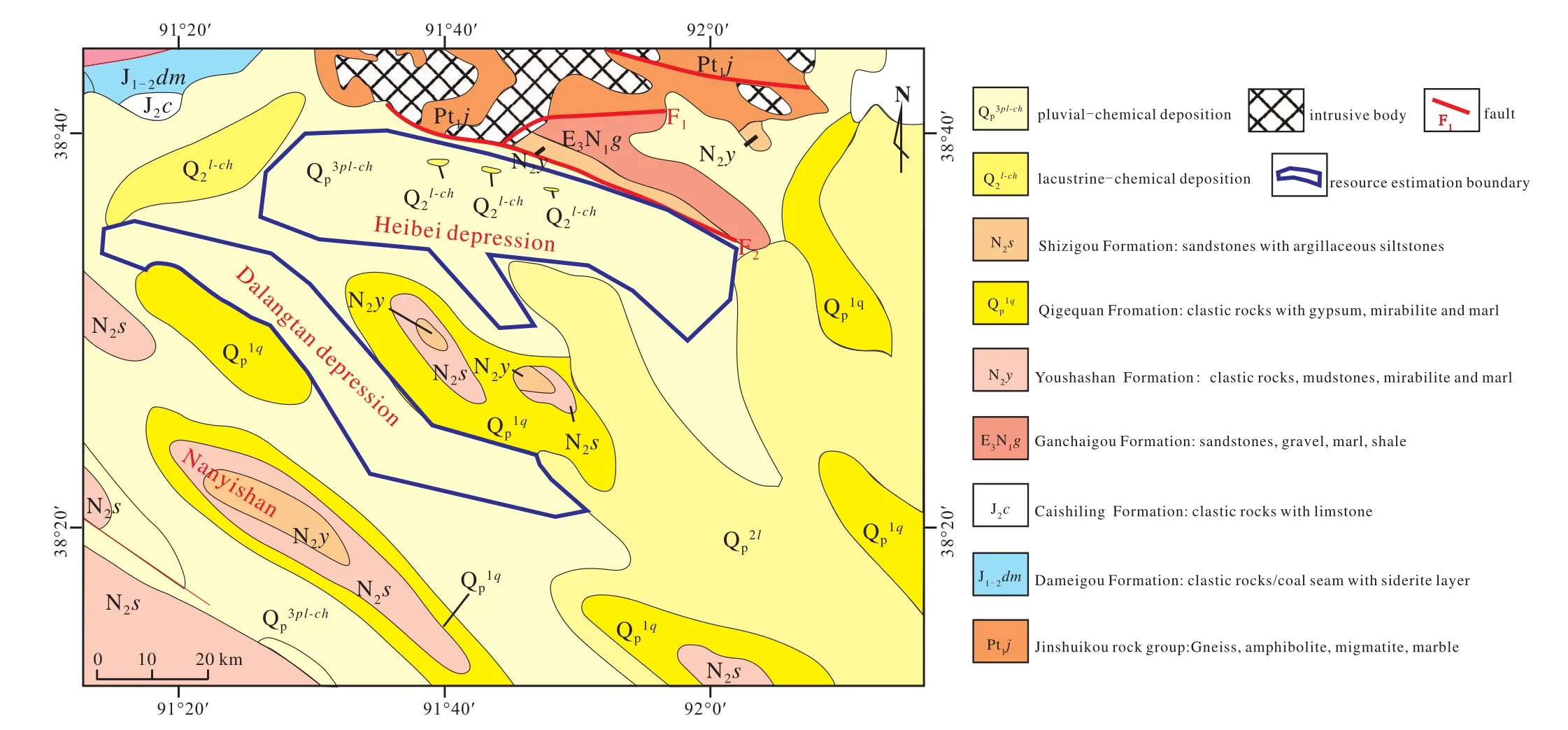
Fig. 1.The Quaternary deep potassium rich brine resource region in the Dalangtan and Heibei depression of the western Qaidam Basin. (modified from Zhang XT, 2007)
4. Recent developments in China in the exploration of marine potash
4.1. The determination of a new type of polyhalite potash ore in the Sichuan Basin
Sichuan Basin is rich in potash resources and although the solid phase and liquid phase of potash deposits are widely distributed, they mainly occur in the Triassic Jialingjiang-Leikoupo Formation. According to the previous survey, the polyhalite displays a prospect that is high in resources.However, most of the Triassic polyhalite in the Sichuan Basin is deeply buried, with the exception of the polyhalite around Huaying mountain fault which is shallow. Difficulties arise with complex structures with regard to exploration and development. Due to the fact that polyhalite with the gypsum,the anhydrite and the dolomite are usually dense massive intergrowths, this kind of polyhalite is not easily dissolved in water. Employing the fracturing method will likely encounter problems such as, hydration and plasticity. Compared with easily soluble potash resources, deep polyhalite mining is rather difficult. The objective conditions, which are difficult to mine at levels far beneath the surface but have scant resources in shallow layers and complex structures, that formed in the past indicate "polyhalite in Sichuan has no industrial value, known as 'dull mine'". However, polyhalite is a kind of high quality slow-release potash fertilizer, which has great strategic significance in terms of a solution to the reserve resources of potash in China. If we provide analysis using these new ideas, and develop scientifically and effectively, an excellent opportunity and a great challenge can be presented to Chinese geosciences and industry (Zheng MP et al., 2010). Under the guidance of Zheng MP, the potash resource surveys project team paid attention to the research on the cause and use of polyhalite 10 years ago, and Professor Anlianying from Chengdu University of Technology arranged to carry out research on the dissolution experiment of polyhalite. At the present time, many aspects and identifications have been obtained (An LY et al., 2008, 2010;Zhao XY et al., 2011). In 2012, the potash research team conducted a survey of polyhalite in the Changshou region of eastern Sichuan. A large number of dispersed grains/gravels of primary polyhalite was found in the salt rocks of the Jialingjiang formation of the Triassic in the Changping 3 well(Wang SL et al., 2014), which was the main source of K+in the salt. This discovery dictated a new direction for the survey of potash resources in the Sichuan Basin.
In general, potassium sulfate and magnesium sulfate in polyhalite are soluble in water, while gypsum, which is insoluble in water, forms a protective membrane around the periphery of polyhalite particles, making the polyhalite insoluble again in water. As a result, it is difficult for polyhalite to react with water in the interaction with gypsum or dolomite (Fig. 2), however, the dispersed polyhalite in salt rocks is easy to dissolve (Fig. 3). Therefore, it is considered that the latter may be worthy of dissolution in order to exploit it. In 2017, the Hengcheng company successfully achieved the butt well and mining dissolution experiment in dispersed polyhalite bearing salt layers (Fig. 4), indicating that it is anticipated this kind of potash ore layer will be developed and utilized. After the author had been in the field, he further pointed out that the stable distribution and thick layer of polyhalite is a "new type of polyhalite potash ore", which has been unanimously approved by the company and the Sichuan geology and mineral department.
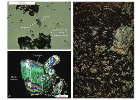
Fig. 2.Petrological and mineralogical characteristics of saline rock with polyhalite. a–water leaching reaction of polyhalite; b–microscopic features of saline rock with polyhalite (orthogonal light); c–core photographs of saline rock with polyhalite.
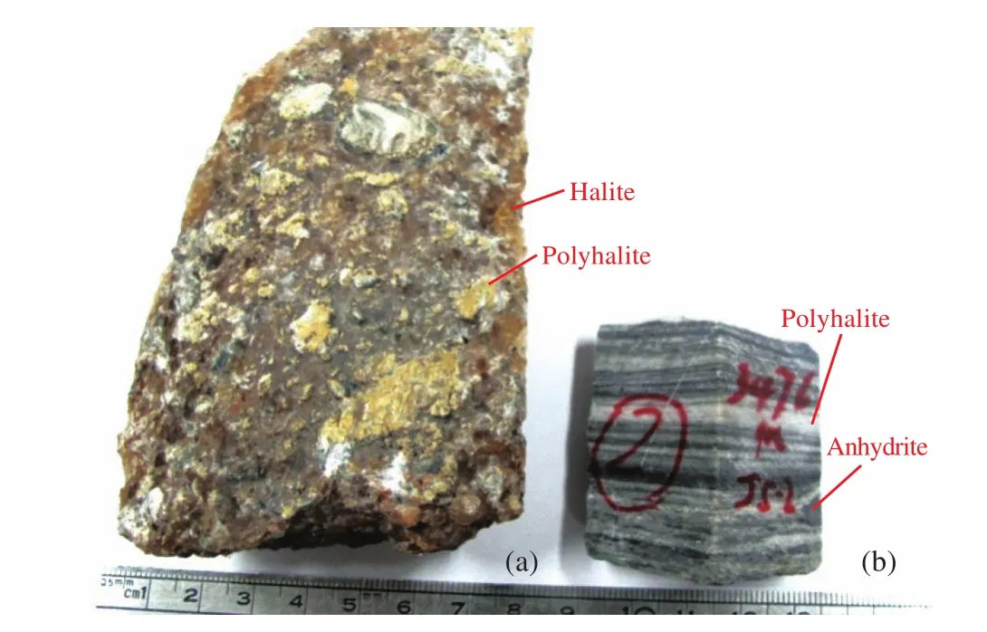
Fig. 3.Two types of polyhalite ore. a–The sample type of dispersed polyhalite in salt rocks which is easy to dissolve; b–The sample type of the polyhalite with the anhydrite, being dense massive intergrowths, which is hard to be dissolved in water.
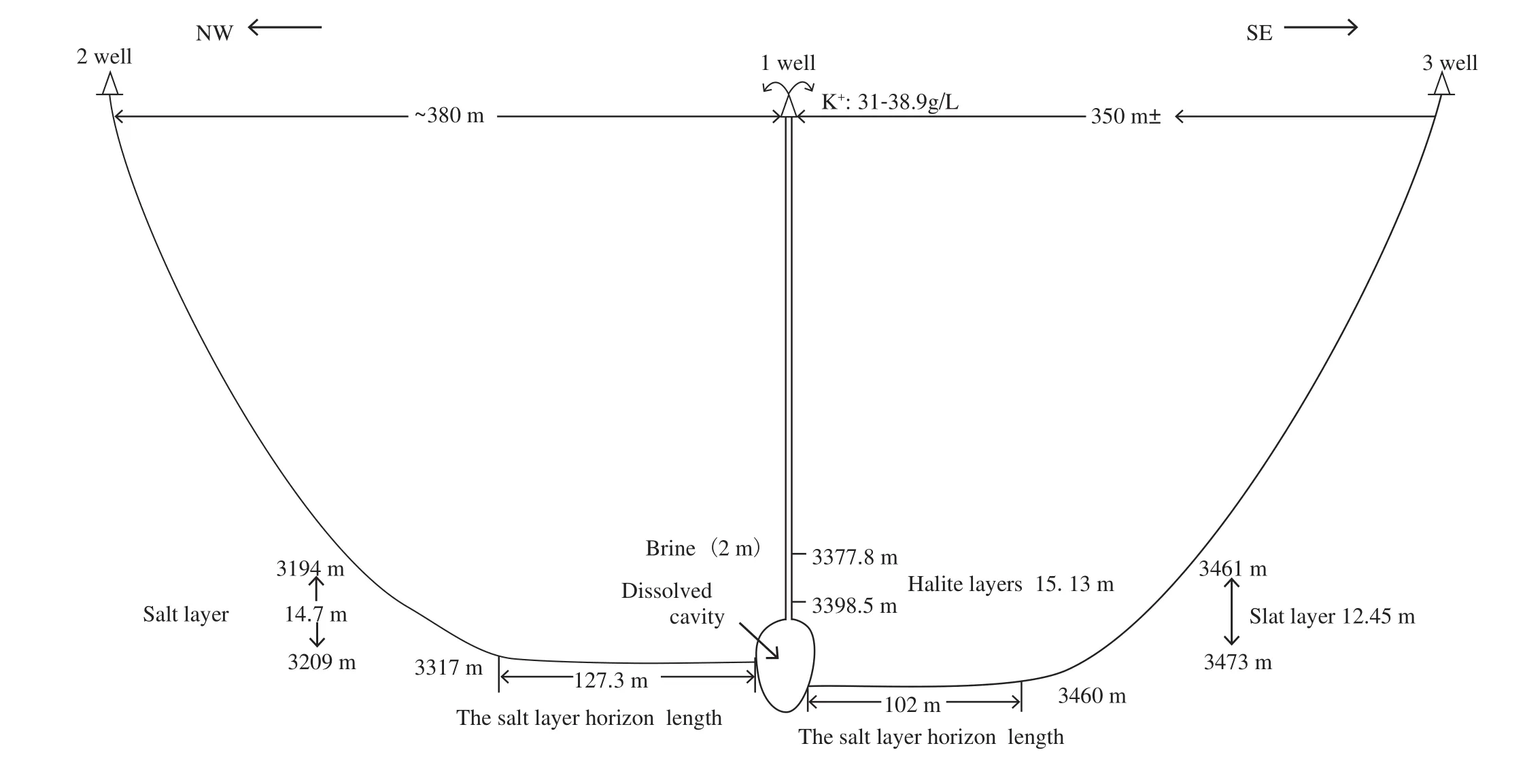
Fig. 4.A schematic diagram of the experiment on the dissolution and mining of the new type of polyhalite potash ore (simplified according to Dazhou Heng Cheng Energy (Group) CO., LTD).
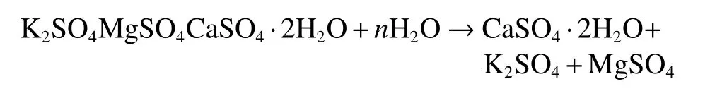
When polyhalite meets water, it reacts as follows:
The distribution of the new type of polyhalite potash ore is stable in the Sichuan Basin. The discovery of a thick and large-scale "new type of polyhalite potash ore" provides an important prospect for slow-release potash fertilizer and a huge amount of polyhalite development in this area. The prospective resources of potash could be in the billions of tons, measured by preliminary data. The determination of a new type of polyhalite potash ore breaks the traditional recognition that polyhalite is a "dull mine", and that the new type of polyhalite potash ore is selected from the traditional,indicating that the new type of polyhalite potash ore can be utilized. This discovery provides a new direction for potash surveys in the Sichuan Basin.
4.2. New evidence of potash forming in Jurassic of Lanping-Simao Basin
Some scholars believe that the potash deposit in the Mengye mine in southwestern Yunnan is mainly continental facies (LI MH et al., 2015), but most scholars believe that the potash deposit in the Mengye mine in southwestern Yunnan is a marine sedimentary environment (Liu Q et al., 1986; Xu XS and Wu JL, 1983; Shuai KY, 1987; Qu YH et al., 1997,1998). However, controversy has emerged in the potash age,which directly affects the future direction of potash prospecting within the region. Based on the previous potassium prospecting and research work in southwestern Yunnan (Zheng MP et al., 2014), the strontium isotope analysis of several mine salt samples shows the source of the salt in the Mengye mine of the Simao Basin in Yunnan to be seawater (Zheng ZJ et al., 2012; Miao ZY, 2018), which can be compared with the strontium isotope data of Jurassic seawater. However, the surrounding rocks in contact with the potash ore are typical continental sediments. These provide geochemical and sedimentary constraints for exploring the formation mechanism and distribution law of potash in this region. It is further demonstrated that the "two-storey potash forming model", reveals a good prospect for potash exploration in southwestern Yunnan.
4.3. The prognosis of potash salt resources and the discovery of high-grade bromine in the Kuqa depression of the Tarim Basin
4.3.1. The forecast for potash resources in the Kuqa depression, Tarim Basin
Based on the review and chemical analysis of the anhydrite and salt debris from oil exploration drilling in the Tarim Basin, potassium anomalies and potash mineralization(K = 0.52%, that is, KCl = 1.00%, is anomalous; K = 1.05%,that is, KCl = 2.00%, is mineralization.) were found in Yangta 4 and Yangta 6 Wells in the south of the Kuqa depression. As shown in figure 5, the mineralization of the Yangta 4 Well was the highest and salinity, and the mineralization scale is the largest, with the K content up to 7.83%, while the Cl content generally around 20% to 50%. The lithology is potash bearing salt rocks or argillaceous potash bearing salt rocks(KCl = 14.94%), which can be divided into three mineralization periods: The upper potash mineralization period depth is 5141–5171 m, 30 m thick, and the average content of K is 3.71%. This periods lithology is mainly sylvite; The middle potash mineralization period depth is 5181–5192 m, 11 m thick, and the average content of K is 4.89%. The mid-upper part of this period’s lithology is mainly sylvite and potassium bearing halite, and in the mid-lower part of the argillaceous the ingredient is increased. The lower potash mineralization depth is 5196–5218 m, which is comprised of three layers of interbedded potassium bearing halite and halite layers. The accumulative thickness of the potash bearing salt layers is 9 m, the average content of K is 2.31%, and the cumulative thickness of the mineralization sections is 50 m. The mineralization section of potash bearing salt in Yangta 6 well is one layer, with a K content of 1.07%,a depth of 5078–5079 m and a thickness of 1 m. The main lithology is potassium-bearing halite, and the mineralization is weak.
According to the well seismic calibration of the Yangta 4 well, wave impedance and gamma joint inversion were carried out for the potash containing target layer of Yangtake area (Fig. 6). The potash bearing strata in Yangtake area was distributed in a North-East South-West direction, and the potash Wells in Yangta 4 and Yangta 6 were used as the boundary in the South, and the potash bearing area was 133 km2. According to the above parameters of Yangta 4 and Yangta 6 wells, the average proportion of potash ore is 1.993 kg/m3, and the average thickness of potash ore is 25.5 m in the Yangta 4 and Yangta 6 wells, and the weighted average grade value of ore KCl in Yangta 4 and Yangta 6 wells is 7.11%. The prospective resource of potash was calculated,and the predicted resource quantity of KCl = area × thickness ×ore specific gravity × grade = 133 × 106m2× 25.5m ×1.993×103kg/m3×7.11% ×10-3t/kg= 4.8×10⁸t.
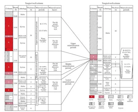
Fig. 5.Comparison of mineralization of potash bearing strata between the Yangta4 well and the Yangta6 well in the Kuqa depression, Tarim Basin, China.
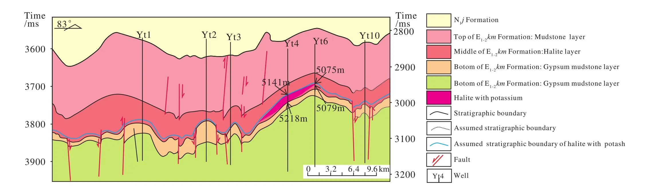
Fig. 6.A section map of the potash-bearing salt layer of the Yangtak tectonic seismic interpretation in the Kuqa depression, Tarim Basin,China.
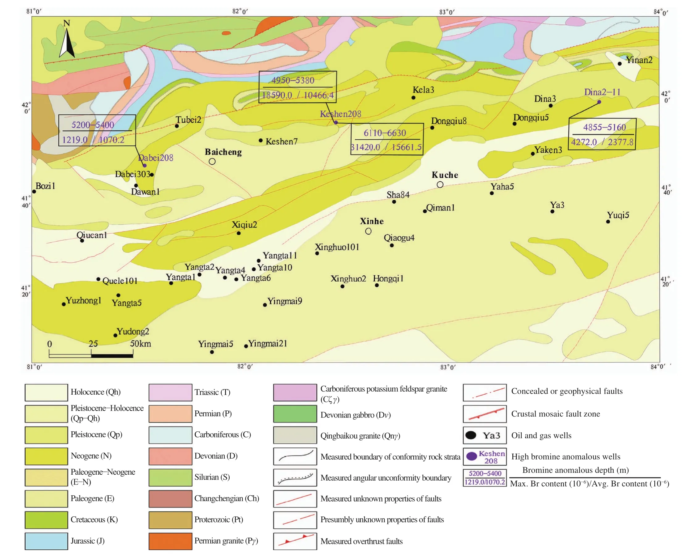
Fig. 7.Well location distribution with abnormal bromine characteristics in the Kuqa depression.
4.3.2. The recent discovery of high-grade bromine ore in Tarim Basin
In the Kuqa depression and the southwestern Tarim depression of the Tarim Basin (Fig. 7, Fig. 8), the salt debris of oil and gas drilling was reviewed by using the method of"co-exploration of hydrocarbon and potash". After repeated chemical analysis of the debris, high bromine salt debris was found in the deep Paleogene of Keshen 208 well in the Kuqa depression and Wubo 1 well in the southwestern Tarim depression. Within the depth range (4950–5380 m,6110–6630 m) of Keshen 208 well, the content of bromine in the argillaceous (gypsum) halite and the salt (gypsum)mudstone halite debris is more than 0.60% and 3.00% in some parts. Within the depth range (6430–6676 m) of the Wubo 1 well, the content of bromine in the gypsum (gypsum bearing)halite and the salt anhydrite debris is between 0.68%–0.78% and 1.00% in some areas. This initial discovery of high bromine salt rocks debris reflects the huge potential for bromine exploration in the southwestern Tarim depression and the Kuqa depression, and is of great significance for the prediction of potash resources.
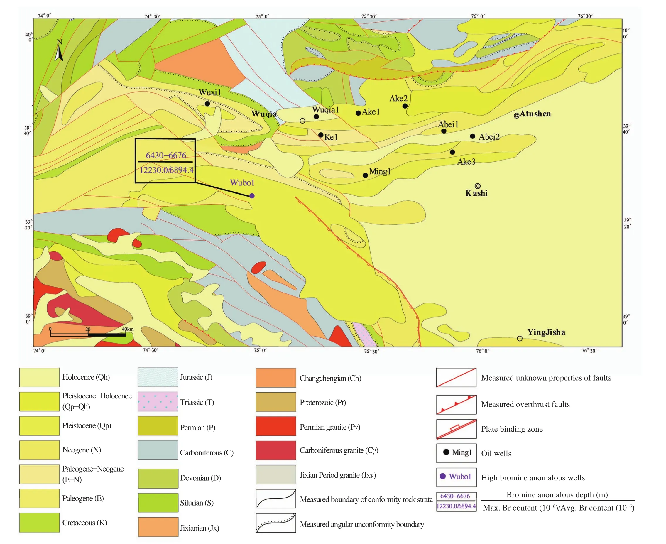
Fig. 8.Well location distribution with abnormal bromine characteristics in the northwest Tarim region.
5.Conclusions
Under the guidance of the new potash formation theory of continental facies in China, the total KCl resource amount in the Quaternary potassium bearing brine in the western Qaidam Basin increased by 350 Mt, providing an important resource guarantee for the new potash salt resource base of Qaidam and future food security. Substantial progress has been made in potash prospecting in marine facies. The determination of a new type of polyhalite potash ore in Sichuan has "activated" a large amount of polyhalite that has long been considered "dull mine", indicates a new direction for potash prospecting in Sichuan Basin. It further proved the era and origin of Mengye potash mine, which indicated the prospect of deep potash explorations in Jurassic. The predicted resource quantity of KCl in the Tarim Kuqa depression is estimated to be 480 Mt, which shows the prospect of potash resources to be high. The discovery of the Paleogene high-bromine salt rocks in the southwestern Tarim depression and Kuqa depression not only increase the available salt minerals in this area, but also anticipates, potash prospecting in the new area of the Tarim Basin.
Acknowledgment
This work was funded by the geological surveys secondary project of CGS of MNR, "Survey and evaluation of potash mineral prospect in western regions of China"(DD20160054). the national Science Foundation of China and Joint foundation (U1407207), Task of "Potash-rich law,strategic constituency and deep detection technology demonstration in key potash bearing basins"(2017YFC0602806), belonging to the National key research and development plan "Deep land resources exploration and exploitation". The anonymous reviewers, Dr. Hao Zi-guo, and Dr. Yang Yan revised this manuscript with valuable suggestions and comments, the authors would like to express sincerely thanks to them.
杂志排行
China Geology的其它文章
- “Source-Diagenesis-Accumulation” enrichment and accumulation regularity of marine shale gas in southern China
- The geothermal formation mechanism in the Gonghe Basin: Discussion and analysis from the geological background
- The evolution of the Huangling uplift and its control on the accumulation and preservation of shale gas
- Ordovician sequence stratigraphy and correlation in the Middle-Upper Yangtze region,South China
- Multi-factor sensitivity analysis on the stability of submarine hydrate-bearing slope
- Petrogenesis of the microcrystalline-dioritic enclaves from Jiuling granitoids in the eastern segment of Jiangnan Orogen and constraints on magma source materials